The Andes, Andes Mountains or Andean Mountain Range are the longest continental mountain range in the world, forming a continuous highland along the western edge of South America. The range is 8,900 km (5,530 mi) long, 200 to 700 km wide, and has an average height of about 4,000 m (13,123 ft). The Andes extend from north to south through seven South American countries: Venezuela, Colombia, Ecuador, Peru, Bolivia, Chile and Argentina.

The Republic of Colombia is situated largely in the north-west of South America, with some territories falling within the boundaries of Central America. It is bordered to the north-west by Panama; to the east by Brazil and Venezuela; to the south by Ecuador and Peru; and it shares maritime limits with Costa Rica, Nicaragua, Honduras, Jamaica, the Dominican Republic, and Haiti.

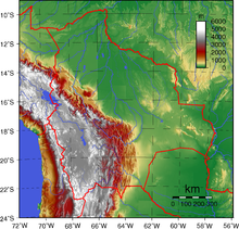
The geography of Bolivia includes the Eastern Andes Mountain Range which bisects Bolivia roughly from north to south. To the east of that mountain chain are lowland plains of the Amazon Basin, and to the west is the Altiplano which is a highland plateau where Lake Titicaca is located. Bolivia's geography has features similar to those of Peru which abuts Bolivia's northwest border; like Bolivia, Peru is bisected from north to south by the Eastern Andes Mountains, and these two countries share Lake Titicaca which is the highest navigable lake on Earth. Unlike Peru, however, Bolivia is one of the two landlocked countries in South America, the other being Paraguay which is located along Bolivia's southeast border.

Chuquisaca is a department of Bolivia located in the center south. It borders on the departments of Cochabamba, Tarija, Potosí, and Santa Cruz. The departmental capital is Sucre, which is also the constitutional capital of Bolivia.

The American Cordillera is a chain of mountain ranges (cordilleras) that consists of an almost continuous sequence of mountain ranges that form the western "backbone" of the Americas. Aconcagua is the highest peak of the chain. It is also the backbone of the volcanic arc that forms the eastern half of the Pacific Ring of Fire.
A cordillera is an extensive chain and/or network system of mountain ranges, such as those in the west coast of the Americas. The term is borrowed from Spanish, where the word comes from cordilla, a diminutive of cuerda ('rope').

The Yungas is a bioregion of a narrow band of forest along the eastern slope of the Andes Mountains from Peru and Bolivia, and extends into Northwest Argentina at the slope of the Andes pre-cordillera. It is a transitional zone between the Andean highlands and the eastern forests. Like the surrounding areas, the Yungas belong to the Neotropical realm; the climate is rainy, humid, and warm.

The Cordillera Occidental is the lowest in elevation of the three branches of the Colombian Andes. The average altitude is 2,000 m (6,600 ft) and the highest peak is Cerro Tatamá at 4,100 m (13,500 ft). The range extends from south to north dividing from the Colombian Massif in Nariño Department, passes north through Cauca, Valle del Cauca, Risaralda, Chocó, and Caldas Departments to the Paramillo Massif in Antioquia and Córdoba Departments. From this massif the range divides further to form the Serranías de Ayapel, San Jerónimo and Abibe. Only to recede into the Caribbean plain and the Sinú River valley.

The Cordillera Oriental is the widest of the three branches of the Colombian Andes. The range extends from south to north dividing from the Colombian Massif in Huila Department to Norte de Santander Department where it splits into the Serranía del Perijá and the Cordillera de Mérida in Venezuelan Andes. The highest peak is Ritacuba Blanco at 5,410 m (17,750 ft) in the Sierra Nevada del Cocuy.

The Cordillera Central is a Bolivian mountain range that divides the three river basins in the country and also has the second highest peaks in Bolivia. It is rich in minerals and starts in the north with Chawpi Urqu and the three Palumanis that were in the south up to Zapaleri, forming a border with Chile and Argentina. The Cordillera Central is divided into three sections:

The puna grassland ecoregion, of the montane grasslands and shrublands biome, is found in the central Andes Mountains of South America. It is considered one of the eight Natural Regions in Peru, but extends south, across Chile, Bolivia, and western northwest Argentina. The term puna encompasses diverse ecosystems of the high Central Andes above 3200–3400 m.
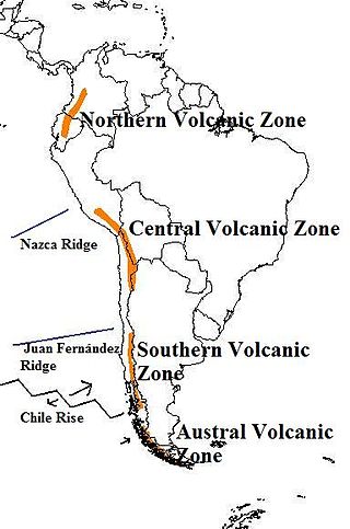
The Andean Volcanic Belt is a major volcanic belt along the Andean cordillera in Argentina, Bolivia, Chile, Colombia, Ecuador, and Peru. It is formed as a result of subduction of the Nazca Plate and Antarctic Plate underneath the South American Plate. The belt is subdivided into four main volcanic zones which are separated by volcanic gaps. The volcanoes of the belt are diverse in terms of activity style, products, and morphology. While some differences can be explained by which volcanic zone a volcano belongs to, there are significant differences within volcanic zones and even between neighboring volcanoes. Despite being a type location for calc-alkalic and subduction volcanism, the Andean Volcanic Belt has a broad range of volcano-tectonic settings, as it has rift systems and extensional zones, transpressional faults, subduction of mid-ocean ridges and seamount chains as well as a large range of crustal thicknesses and magma ascent paths and different amounts of crustal assimilations.

Geology of Colombia refers to the geological composition of the Republic of Colombia that determines its geography. Most of the emerged territory of Colombia covers vast areas within the South American plate, whereas much submerged territory lies within the Caribbean plate and the Nazca plate.
The Casamayoran age is a period of geologic time within the Early Eocene epoch of the Paleogene, used more specifically within the South American land mammal age (SALMA) classification. It follows the Itaboraian and precedes the Mustersan age.

Los Patos is a mountain in the Andes mountain range of South America. The peak is located on the international border of the Catamarca Province of Argentina and the Atacama Region of Chile. It has a summit elevation of 6,239 metres (20,469 ft).

The Andean orogeny is an ongoing process of orogeny that began in the Early Jurassic and is responsible for the rise of the Andes mountains. The orogeny is driven by a reactivation of a long-lived subduction system along the western margin of South America. On a continental scale the Cretaceous and Oligocene were periods of re-arrangements in the orogeny. The details of the orogeny vary depending on the segment and the geological period considered.

The geology of Bolivia comprises a variety of different lithologies as well as tectonic and sedimentary environments. On a synoptic scale, geological units coincide with topographical units. The country is divided into a mountainous western area affected by the subduction processes in the Pacific and an eastern lowlands of stable platforms and shields. The Bolivian Andes is divided into three main ranges; these are from west to east: the Cordillera Occidental that makes up the border to Chile and host several active volcanoes and geothermal areas, Cordillera Central once extensively mined for silver and tin and the relatively low Cordillera Oriental that rather than being a range by its own is the eastern continuation of the Central Cordillera as a fold and thrust belt. Between the Occidental and Central Cordillera the approximately 3,750-meter-high Altiplano high plateau extends. This basin hosts several freshwater lakes, including Lake Titicaca as well as salt-covered dry lakes that bring testimony of past climate changes and lake cycles. The eastern lowlands and sub-Andean zone in Santa Cruz, Chuquisaca, and Tarija Departments was once an old Paleozoic sedimentary basin that hosts valuable hydrocarbon reserves. Further east close to the border with Brazil lies the Guaporé Shield, made up of stable Precambrian crystalline rock.
Salta Basin or Salta Rift Basin is a sedimentary basin located in the Argentine Northwest. The basin started to accumulate sediments in the Early Cretaceous (Neocomian) and at present it has sedimentary deposits reaching thicknesses of 5,000 metres (16,000 ft). The basin contains seven sub-basins: Tres Cruces, Lomas de Olmedo, Metán, Alemanía, Salfity, El Rey, Sey and Brealito. The basin environment has variously been described as a "foreland rift" and an "intra-continental rift". The basin developed under conditions of extensional tectonics and rift-associated volcanism.
The Bolivian tin belt is a mineral-rich region in the Cordillera Oriental of Bolivia. Being a metallogenetic province the Bolivian tin belt is rich in tin, tungsten, silver and base metals. The Bolivian tin belt follows the same bend as the Bolivian orocline. The mineralizations of the belt were formed episodically beginning in the Triassic and with the youngest known mineralizations dating to the Miocene.