The Guiana Shield is one of the three cratons of the South American Plate. It is a 1.7 billion-year-old Precambrian geological formation in northeast South America that forms a portion of the northern coast. The higher elevations on the shield are called the Guiana Highlands, which is where the table-like mountains called tepuis are found. The Guiana Highlands are also the source of some of the world's most well-known waterfalls such as Angel Falls, Kaieteur Falls and Cuquenan Falls.

Sipaliwini is the largest district of Suriname, located in the south. Sipaliwini is the only district that does not have a regional capital, as it is directly administered by the national government in Paramaribo. Sipaliwini District includes disputed areas, with the southwestern region controlled and administered by Guyana, whereas the southeastern region is controlled by French Guiana.

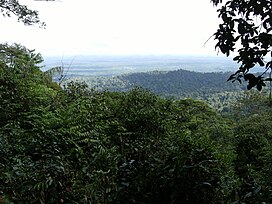
The Central Suriname Nature Reserve is a conservation unit in Suriname. It preserves an area of tropical rainforest. The reserve is in pristine condition.

Brownsweg is a town and resort in Suriname in the Brokopondo District. Its population at the 2012 census was 4,793.
The fauna of Indonesia is characterised by high levels of biodiversity and endemicity due to its distribution over a vast tropical archipelago. Indonesia divides into two ecological regions; western Indonesia which is more influenced by Asian fauna, and the east which is more influenced by Australasian species.

The wildlife of Ivory Coast consists of the flora and fauna of this nation in West Africa. The country has a long Atlantic coastline on the Gulf of Guinea and a range of habitat types. Once covered in tropical rainforest, much of this habitat has been cleared, the remaining terrain being gallery forests and savanna with scattered groups of trees, resulting in a decrease in biodiversity. As of 2016, 252 species of mammal had been recorded in Ivory Coast, 666 species of bird, 153 species of reptile, 80 species of amphibian, 671 species of fish and 3660 species of vascular plant.
Galibi is a resort in Suriname, located in the Marowijne District. Its population at the 2012 census was 741. Galibi is a tribal area inhabited by an indigenous population of Kalina Amerindians.

Many areas of Vietnam are under protection. While the national reserves cover small areas of scientific significance with restricted access, the national parks also cover wetlands of Ramsar designated areas and BirdLife International inscribed bird areas. The largest of the national parks initially covered were the Cúc Phương National Park, the Cát Tiên National Park, and the Côn Đảo National Park which to start with were forest areas cum reserves or prohibited areas. The objective for creating national parks was to allow access to the reserved areas as a part of ecotourism and cultural needs with full attention to the basic approach of conservation of natural environmental resources.

Brownsberg Nature Park is a nature park located in Suriname. The site measures 12,000 ha and is located in the district of Brokopondo around 130 km south from the capital city Paramaribo. The 500-meter high Brownsberg is the central point of the park. The site is located near the Brokopondo Reservoir. The park is managed by STINASU. Often the people of Suriname use the word Brownsberg as simple variant of Brownsberg Nature Park. Local people also write it as Bruijnsberg, pronounced as Braynsberg.
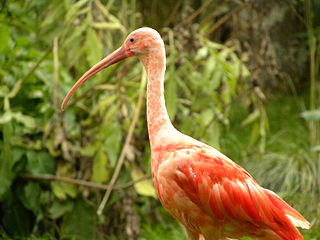
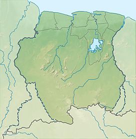
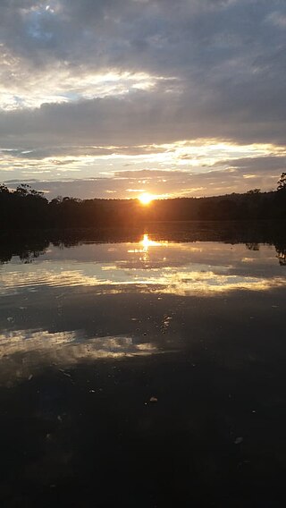
The biodiversity of Suriname is high, mostly because of the variety of habitats and warm temperatures. The average annual temperature in the coastal area is between 26° and 28°C. Suriname can be divided into four major ecological zones, namely from north to south;
- The young coastal plain
- The old coastal plain
- The Savannah or Zanderij belt
- The interior residual uplands
The Maicuru Biological Reserve, is a strictly protected biological reserve in the state of Pará, Brazil. It covers 11,518 square kilometres (4,447 sq mi) of Amazon rainforest.

The Guianan moist forests (NT0125) is an ecoregion in the east of Venezuela, north of Brazil and the Guyanas. It is in the Amazon biome. The climate is hot and humid, with two rainy seasons each year. As of 1996 the tropical rainforest habitat was relatively intact, although there were mounting threats from illegal logging and gold mining.

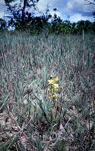
The Sipaliwini Savanna is a protected area and nature reserve in Suriname. The reserve is located to the south of the Sipaliwini River in the far south of the country. The reserve measures 100,000 hectares, and has been a protected area since 1972. The majority of the reserve consists of a savannah which in turn is a continuation of the Brazilian Tumucumaque Mountains National Park. The reserve is in pristine condition with almost no human habitation.
Alfonsdorp is a village of indigenous Lokono people in the Albina resort of the Marowijne District of Suriname. The village is located on the East-West Link. The Wanekreek Nature Reserve is located near the village.
The Boven Coesewijne Nature Reserve is a protected area and nature reserve in Suriname. The reserve is located along the headwaters of the Coesewijne River. It is important for the brown sand and white sand savannahs located within the reserve.

The Coppename Monding Nature Reserve is a protected area and nature reserve in Suriname. The reserve is located near the mouth of the Coppename River. The reserve measures 12,000 hectares, and has been a protected area since 1961.
The Brinckheuvel Nature Reserve is a protected area and nature reserve in Suriname. The reserve is located on the Saramacca River, and is the most southern savannah of the Savannah Belt. The Mindrineti River flows through the reserve. The reserve measures 6,000 hectares, and has been a protected area since 1961.
The Copi Nature Reserve is a protected area and nature reserve in Suriname. The reserve is located along the blackwater Cassewinica Creek. The reserve measures 18,000 hectares, and has been a protected area since 1986.

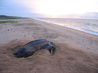
The Amana Nature Reserve is a nature reserve in French Guiana, France. It has been protected because it is one of the world's largest leatherback sea turtle nesting sites. It is part of the communes of Awala-Yalimapo and Mana.