
Suriname, officially the Republic of Suriname, is a country in northern South America, sometimes considered part of the Caribbean and the West Indies. Suriname is a developing country with a medium level of human development; its economy is heavily dependent on its abundant natural resources, namely bauxite, gold, petroleum, and agricultural products. Suriname is a member of the Caribbean Community (CARICOM), the United Nations, and the Organisation of Islamic Cooperation.

The Central Suriname Nature Reserve is a conservation unit in Suriname. It preserves an area of tropical rainforest. The reserve is in pristine condition.

Wageningen is a community resort and an agricultural place in the Republic of Suriname and located in the coastal area of West Suriname in the Nickerie District, at the harbour of the Nickerie River across the right estuary of the Maratakka River. The town was known as the rice centre of Suriname, Wageningen has been founded in 1949 and named after the Dutch city of Wageningen.
Julianatop is the highest mountain in Suriname at 1,280 metres (4,199 ft). It is located in the Sipaliwini District. The mountain is named after Juliana of the Netherlands. The Amerindian name of the mountain is Ipinumin.
The Wilhelminagebergte is a mountain range in the district of Sipaliwini in central Suriname. It extends about 113 km (70 mi) from west to east. It is named after Queen Wilhelmina. The Wilhelminagebergte is part of the Tumucumaque Uplands of the Guiana Shield. It belongs to the very ancient (Precambrian) Guiana Highlands. Most of it is in the Central Suriname Nature Reserve.
Rudi Kappel Airstrip is located 9 kilometres (5.6 mi) south of the Tafelberg tepui in Suriname. It was constructed as part of Operation Grasshopper. It used to be named Tafelberg Airstrip, but was renamed Rudi Kappel Airstrip, after the co-pilot of a flight that crashed near Vincent Fayks Airport on 6 October 1959.
Käyser Airstrip, also Käyser Jan Gouka Airstrip is near the Käyser Mountains range in Sipaliwini District, Suriname. It was constructed as part of Operation Grasshopper and has one long grass runway. Fishing and wildlife tours are prime users of the airstrip.

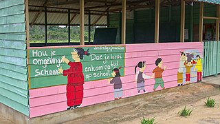
Weg naar Zee is a resort in Suriname, located in the Paramaribo District. Its population at the 2012 census was 16,037, and has a large East Indian population. The name can be translated as "road to sea", and it is indeed the road to the sea. Weg naar Zee is home to the Open Air Crematorium which opened in 1968, and there is a pilgrimage site for Hindus nearby. In 1968, oil had been discovered in Weg naar Zee, and is being exploited by Staatsolie. In 2015, a mangrove conservation effort was launched. The rising sea tide due to climate change, and the decline for the forests, increase the risk of flooding. The project aims to increase the number of mangrove forests near the coast. A part of the resort is still an agricultural area.
Boven Coppename is a resort in Suriname, located in the Sipaliwini District. Its population at the 2012 census was 539. The resort is mainly inhabited by indigenous people of the Tiriyó, and Maroons of the Kwinti tribe. The main village is Bitagron. Other villages include Corneliskondre and Donderskamp.
Paloemeu or Palumeu is an Amerindian village in the interior of Suriname, situated at the site where the Paloemeu River joins the Tapanahoni River. Most inhabitants of the village are native Tiriyó Amerindians. The remainder belongs to the Wayana, and Aparai tribes. The Bosatlas in 1968 identified the village as Pepejoe which was incorrect according to the New West Indian Guide.

Ronald Edwin Naar was a Dutch mountaineer. He was born in The Hague, and was an active climber from the 1970s onwards. He made the first ascents of Peak 6393 in the Karakoram, Djo Drake in Bhutan, Tilleketinda on Greenland and Duivelsei in Suriname. He made the first Dutch ascents of several mountains, including the Eiger and K2, and was the first Dutch climber to complete the Seven Summits. He wrote several books about climbing.
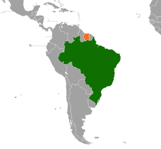
Brazil–Suriname relations are the bilateral relations between the Federative Republic of Brazil and the Republic of Suriname. Diplomatic relations were established on 3 March 1976. Brazil has an embassy in Paramaribo since the independence of Suriname on 25 November 1975. Suriname has an embassy in Brasília since 1976, and a consulate in Belém since 2012.
Johannes Gijsbert Willem Jacobus (Johan) Eilerts de Haan was a Dutch explorer and soldier. Eilerts de Haan Nature Park in Suriname is named for him.

The Sipaliwini Savanna is a protected area and nature reserve in Suriname. The reserve is located to the south of the Sipaliwini River in the far south of the country. The reserve measures 100,000 hectares, and has been a protected area since 1972. The majority of the reserve consists of a savannah which in turn is a continuation of the Brazilian Tumucumaque Mountains National Park. The reserve is in pristine condition with almost no human habitation.
Hendriktop is a mountain in Suriname at 908 metres (2,979 ft). It is part of the Emma Range and is located in the Sipaliwini District. The mountain is named after Hendrik of the Netherlands. The mountain was first climbed by A. van Stockum in 1902.

Voltzberg is a mountain in Suriname at 240 metres (787 ft). It is part of the Emma Range and is located in the Sipaliwini District. It is named after the German geologist Friedrich Voltz. Voltzberg used to form a nature reserve together with the close by Raleigh Falls. In 1998, it became part of the Central Suriname Nature Reserve.

Tebutop is a mountain in Suriname at 374 metres (1,227 ft). It is located in the Sipaliwini District.

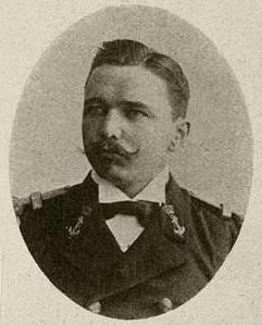
Ronald "Rudi" Elwin Kappel was a Surinamese pilot. He was one of the founders of Luchtvaartbedrijf Kappel-Van Eyck which is now called Surinam Airways, the first airline in Suriname. He also helped construct the Zorg en Hoop Airport, and the Rudi Kappel Airstrip. Kappel died in an air crash near Paloemeu.

Dirk Cornelis Geijskes was a Dutch biologist, ethnologist and curator. He was the first director of the Surinaams Museum. As a biologist, he specialised in dragonflies. He would lead many expeditions into the interior of Suriname. In 1967, he became curator at the Rijksmuseum van Natuurlijke Historie where he started the dragonfly collection. Geijskes is the author of 123 publications, and 25 species have been named after him.
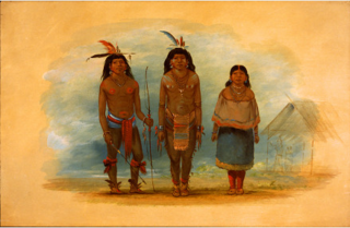
The Taruma are an indigenous people found in the northern Brazil, southern Guyana, and southern Suriname. They used to speak Taruma which is considered critically endangered. The Taruma in Suriname have merged with the Tiriyó, in Brazil they merged with the Wai-wai. The Wapishana village of Maruranau in Guyana still recognises the tribe.
