
Sierra Ballena Shear Zone or SBSZ is a sinistral strike-slip shear zone running across the Uruguayan Shield in eastern Uruguay and the Brazilian state of Rio Grande do Sul. [2] [3] The system was last active in the Precambrian. [2]
Sierra Ballena Shear Zone or SBSZ is a sinistral strike-slip shear zone running across the Uruguayan Shield in eastern Uruguay and the Brazilian state of Rio Grande do Sul. [2] [3] The system was last active in the Precambrian. [2]

Pannotia, also known as the Vendian supercontinent, Greater Gondwana, and the Pan-African supercontinent, was a relatively short-lived Neoproterozoic supercontinent that formed at the end of the Precambrian during the Pan-African orogeny, during the Cryogenian period and broke apart 560 Ma with the opening of the Iapetus Ocean, in the late Ediacaran and early Cambrian. Pannotia formed when Laurentia was located adjacent to the two major South American cratons, Amazonia and Río de la Plata. The opening of the Iapetus Ocean separated Laurentia from Baltica, Amazonia, and Río de la Plata. In 2022 the whole concept of Pannotia has been put into question by scientists who argue its existence is not supported by geochronology, "the supposed landmass had begun to break up well before it was fully assembled".
The Pan-African orogeny was a series of major Neoproterozoic orogenic events which related to the formation of the supercontinents Gondwana and Pannotia about 600 million years ago. This orogeny is also known as the Pan-Gondwanan or Saldanian Orogeny. The Pan-African orogeny and the Grenville orogeny are the largest known systems of orogenies on Earth. The sum of the continental crust formed in the Pan-African orogeny and the Grenville orogeny makes the Neoproterozoic the period of Earth's history that has produced most continental crust.
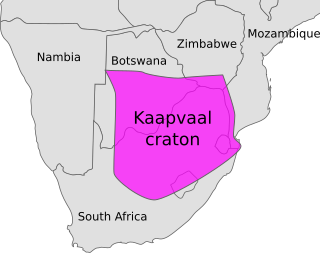
Vaalbara is a hypothetical Archean supercontinent consisting of the Kaapvaal Craton and the Pilbara Craton. E. S. Cheney derived the name from the last four letters of each craton's name. The two cratons consist of crust dating from 2.7 to 3.6 Gya, which would make Vaalbara one of Earth's earliest supercontinents.

The Amazonian Craton is a geologic province located in South America. It occupies a large portion of the central, north and eastern part of the continent and represents one of Earth's largest cratonic regions. The Guiana Shield and Central Brazil Shield constitute respectively the northern and southern exhumed parts of the craton. Between the two shields lies the Amazon Rift, a zone of weakness within the craton. Smaller cratons of Precambrian rocks south of the Amazonian Shield are the Río de la Plata Craton and the São Francisco Craton, which lies to the east.

The Rio de la Plata Craton (RPC) is a medium-sized continental block found in Uruguay, eastern Argentina and southern Brazil. During its complex and protracted history it interacted with a series other blocks and is therefore considered important for the understanding of the amalgamation of West Gondwana. Two orogenic cycles have been identified in the RPC: a 2000 Ma-old western domain representing the old craton and a 700–500 Ma-old eastern domain assigned to the Brasiliano Cycle. It is one of the five cratons of the South American continent. The other four cratons are: Amazonia, São Francisco, Río Apa and Arequipa–Antofalla.

Gondwana was a large landmass, sometimes referred to as a supercontinent. It was formed by the accretion of several cratons, beginning c. 800 to 650Ma with the East African Orogeny, the collision of India and Madagascar with East Africa, and was completed c.600 to 530 Ma with the overlapping Brasiliano and Kuunga orogenies, the collision of South America with Africa, and the addition of Australia and Antarctica, respectively. Eventually, Gondwana became the largest piece of continental crust of the Palaeozoic Era, covering an area of about 100,000,000 km2 (39,000,000 sq mi), about one-fifth of the Earth's surface. It fused with Euramerica during the Carboniferous to form Pangea. It began to separate from northern Pangea (Laurasia) during the Triassic, and started to fragment during the Early Jurassic. The final stages of break-up, involving the separation of Antarctica from South America and Australia, occurred during the Paleogene (from around 66 to 23 million years ago. Gondwana was not considered a supercontinent by the earliest definition, since the landmasses of Baltica, Laurentia, and Siberia were separated from it. To differentiate it from the Indian region of the same name, it is also commonly called Gondwanaland.
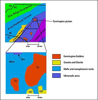
The Carolina Terrane, also called the Carolina Superterrane or Carolinia, is an exotic terrane running ~370 miles (600 km) approximately North-South from central Georgia to central Virginia in the United States. It constitutes a major part of the eastern Piedmont Province.
Pampia was an ancient microcontinent or terrane that collided with Río de la Plata Craton and Río Apas Craton during the Pampean orogeny of late Proterozoic and early Cambrian. It was one of the first terranes to be amalgamated to the old cratons of the east, and was followed by the suturing of Cuyania and Chilenia terranes into the young South American Plate.

The Seychelles Microcontinent is a microcontinent underlying Seychelles in the western Indian Ocean made of Late Precambrian rock.
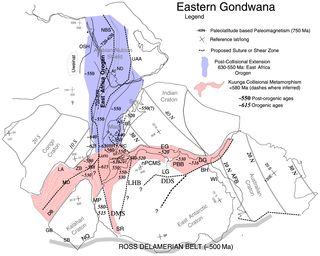
The East African Orogeny (EAO) is the main stage in the Neoproterozoic assembly of East and West Gondwana along the Mozambique Belt.

The geology of Uruguay combines areas of Precambrian-aged shield units with a region of volcanic rock erupted during the Cretaceous and copious sedimentary facies the oldest of which date from the Devonian. Big events that have shaped the geology of Uruguay include the Transamazonian orogeny, the breakup of Rodinia and the opening of the South Atlantic.

The Pampean orogeny was an orogeny active in the Cambrian in the western margin of the ancient landmass of Gondwana. The orogen's remains can now be observed in central Argentina, in particular at the Sierras de Córdoba and other parts of the eastern Sierras Pampeanas. It is uncertain if the orogeny involved at some point a continental collision. The Pampean orogen can be considered both part of the larger Terra Australis orogen and of the Brasiliano orogeny. The Pampean orogeny was succeeded by the Famatinian orogeny further west.
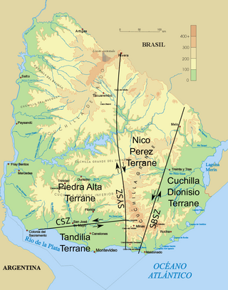
The Sarandí del Yí Shear Zone is a strike slip shear zone in Uruguay. The shear zone has a NNW-SSE orientation and a dextral relative direction. It runs across the Río de la Plata Craton from the coast east of Montevideo in the south to the town of Sarandí del Yí. Sarandí del Yí Shear Zone shows a relative displacement of 40 kilometres (25 mi) and truncates the Uruguayan dyke swarm to the west.
The Adamastor Ocean was a "proto-Atlantic" ocean that formed with the break-up of the Rodinia supercontinent c. 780–750 Ma. It separated the Río de la Plata Craton from the Congo Craton. The inversion of the Adamastor Ocean began about 640 Ma with the development of a large back-arc basin along the western margin of the Kalahari Craton, and the ocean closed when Río de la Plata collided with Kalahari about 545 Ma along the sinistral Sierra Ballena Shear Zone. The São Francisco Craton and the Río de la Plata Craton amalgamated 630–620 Ma, closing the Adamastor Ocean on the South American side and forming the Mantiqueira Mountains around 600 Ma.
The Uruguayan dyke swarms consist of three groups of dykes of Precambrian age that intrude Río de la Plata Craton and Brasiliano Cycle continental crust in Uruguay. The dykes – including the Florida dyke swarm, the Nico Perez dyke swarm, and the Treinta y Tres dyke swarm – are of mafic to intermediate composition and each group lies in a separate tectono-stratigraphic terrane. The rocks of the Florida dyke swarm have been quarried since the 1960s and are used in the construction industry as black dimension stone of very high quality, being marketed as "black granite".
One of the major depositional strata in the Himalaya is the Lesser Himalayan Strata from the Paleozoic to Mesozoic eras. It had a quite different marine succession during the Paleozoic, as most parts of it are sparsely fossiliferous or even devoid of any well-defined fossils. Moreover, it consists of many varied lithofacies, making correlation work more difficult. This article describes the major formations of the Paleozoic – Mesozoic Lesser Himalayan Strata, including the Tal Formation, Gondwana Strata, Singtali Formation and Subathu Formation.

Patagonia comprises the southernmost region of South America, portions of which lie on either side of the Argentina-Chile border. It has traditionally been described as the region south of the Rio Colorado, although the physiographic border has more recently been moved southward to the Huincul fault. The region's geologic border to the north is composed of the Rio de la Plata craton and several accreted terranes comprising the La Pampa province. The underlying basement rocks of the Patagonian region can be subdivided into two large massifs: the North Patagonian Massif and the Deseado Massif. These massifs are surrounded by sedimentary basins formed in the Mesozoic that underwent subsequent deformation during the Andean orogeny. Patagonia is known for its vast earthquakes and the damage they cause.
The geology of Argentina includes ancient Precambrian basement rock affected by the Grenville orogeny, sediment filled basins from the Mesozoic and Cenozoic as well as newly uplifted areas in the Andes.
The geology of Brazil includes very ancient craton basement rock from the Precambrian overlain by sedimentary rocks and intruded by igneous activity, as well as impacted by the rifting of the Atlantic Ocean.
Major South American geological features | |||||
|---|---|---|---|---|---|
| Tectonic plates |  | ||||
| Cratons and shields | |||||
| Structures undergoing subduction | |||||
| Faults and shear zones | |||||
| Rifts and grabens | |||||
| Sedimentary basins | |||||
| Orogenies | |||||
| Metallogenetic provinces | |||||
| Volcanism |
| ||||