Related Research Articles

The African plate, also known as the Nubian plate, is a major tectonic plate that includes much of the continent of Africa and the adjacent oceanic crust to the west and south. It also includes a narrow strip of Western Asia along the Mediterranean Sea, including much of Israel and Lebanon. It is bounded by the North American plate and South American plate to the west ; the Arabian plate and Somali plate to the east; the Eurasian plate, Aegean Sea plate and Anatolian plate to the north; and the Antarctic plate to the south.

The Caledonian orogeny was a mountain-building cycle recorded in the northern parts of the British Isles, the Scandinavian Caledonides, Svalbard, eastern Greenland and parts of north-central Europe. The Caledonian orogeny encompasses events that occurred from the Ordovician to Early Devonian, roughly 490–390 million years ago (Ma). It was caused by the closure of the Iapetus Ocean when the Laurentia and Baltica continents and the Avalonia microcontinent collided.
The Pan-African orogeny was a series of major Neoproterozoic orogenic events which related to the formation of the supercontinents Gondwana and Pannotia about 600 million years ago. This orogeny is also known as the Pan-Gondwanan or Saldanian Orogeny. The Pan-African orogeny and the Grenville orogeny are the largest known systems of orogenies on Earth. The sum of the continental crust formed in the Pan-African orogeny and the Grenville orogeny makes the Neoproterozoic the period of Earth's history that has produced most continental crust.

The Rio de la Plata Craton (RPC) is a medium-sized continental block found in Uruguay, eastern Argentina and southern Brazil. During its complex and protracted history it interacted with a series other blocks and is therefore considered important for the understanding of the amalgamation of West Gondwana. Two orogenic cycles have been identified in the RPC: a 2000 Ma-old western domain representing the old craton and a 700–500 Ma-old eastern domain assigned to the Brasiliano Cycle. It is one of the five cratons of the South American continent. The other four cratons are: Amazonia, São Francisco, Río Apa and Arequipa–Antofalla.

The Trans-Hudson orogeny or Trans-Hudsonian orogeny was the major mountain building event (orogeny) that formed the Precambrian Canadian Shield and the North American Craton, forging the initial North American continent. It gave rise to the Trans-Hudson orogen (THO), or Trans-Hudson Orogen Transect (THOT), which is the largest Paleoproterozoic orogenic belt in the world. It consists of a network of belts that were formed by Proterozoic crustal accretion and the collision of pre-existing Archean continents. The event occurred 2.0–1.8 billion years ago.
See also Line (geometry)
This is a list of articles related to plate tectonics and tectonic plates.
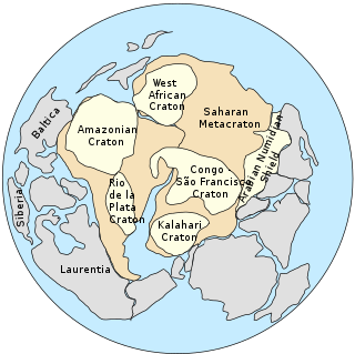
The Saharan Metacraton is a large area of continental crust in the north-central part of Africa. Whereas a craton is an old and stable part of the lithosphere, the term "metacraton" is used to describe a craton that has been remobilized during an orogenic event, but where the characteristics of the original craton are still identifiable. The geology of the continent has only been partially explored, and other names have been used to describe the general area that reflect different views of its nature and extent. These include "Nile Craton", "Sahara Congo Craton", "Eastern Saharan Craton" and "Central Saharan Ghost Craton". This last term is because the older rocks are almost completely covered by recent sediments and desert sands, making geological analysis difficult.

The Tuareg Shield is a geological formation lying between the West African craton and the Saharan Metacraton in West Africa. Named after the Tuareg people, it has complex a geology, reflecting the collision between these cratons and later events. The landmass covers parts of Algeria, Niger and Mali.

The Benue Trough is a major geological structure underlying a large part of Nigeria and extending about 1,000 km northeast from the Bight of Benin to Lake Chad. It is part of the broader West and Central African Rift System.
The Pharusian Ocean is an ancient ocean that existed on Earth from 800 to 635 million years ago, between the break-up of the Rodinia supercontinent and the start of formation of the Pannotia supercontinent.
The Kandi fault zone is a southern extension of the Hoggar fault zone in West Africa, with splays in Benin, Togo and southeastern Ghana. It lies at the southern end of the Trans Saharan belt, a lineament that extends in a southwest direction from Algeria to Benin. The Kandi fault zone is identified with the Sobral fault in northeastern Brazil, considered to be the northern section of the Trans Brazilian Lineament.
The Sobral fault is a major fault in the Borborema geological province of northeastern Brazil, a part of the Transbrasiliano lineament. It is commonly correlated with the Kandi fault in Benin, east of the West African craton. The fault lies in the northwest of Ceará state. It appears to have formed late in the orogeny when the West African craton engaged with the Congo craton, and to have allowed significant dextral strike-slip movement. It was reactivated when South America was breaking away from Africa. In this later phase, a sinistral shear movement of about 100 km seems to have taken place during and after the break-up.
The Foumban Shear Zone, or Central Cameroon Shear Zone (CCSZ), is a fault zone in Cameroon that has been correlated with the Pernambuco fault in northeastern Brazil, which splays from the Trans-Brazilian Lineament. It is part of the Central African Shear Zone (CASZ) and dates to at least 640 million years ago. The zone was rejuvenated several times, usually with a dextral movement, before and during the opening of the South Atlantic in the Cretaceous period.
The Pernambuco Fault or Pernambuco Shear Zone in northeastern Brazil is a fault radiating from the Trans Brazilian Lineament eastwards to the coast, a major geological feature.

Brasiliano orogeny or Brasiliano cycle refers to a series of orogenies from the Neoproterozoic era, exposed chiefly in Brazil but also in other parts of South America. The Brasiliano orogeny is a regional name for the larger Pan-African/Brasiliano orogeny that extended not only in South America but across most of Gondwana. In a wide sense the Brasiliano orogeny includes also the Pampean orogeny. Almeida et al. coined the term Brasiliano Orogenic Cycle in 1973. The orogeny led to the closure of several oceans and aulacogens including the Adamastor Ocean, the Goianides Ocean, the Puncoviscana Ocean and the Peri-Franciscano Ocean.
The Adamastor Ocean was a "proto-Atlantic" ocean that formed with the break-up of the Rodinia supercontinent c. 780–750 Ma. It separated the Río de la Plata Craton from the Congo Craton. The inversion of the Adamastor Ocean began about 640 Ma with the development of a large back-arc basin along the western margin of the Kalahari Craton, and the ocean closed when Río de la Plata collided with Kalahari about 545 Ma along the sinistral Sierra Ballena Shear Zone. The São Francisco Craton and the Río de la Plata Craton amalgamated 630–620 Ma, closing the Adamastor Ocean on the South American side and forming the Mantiqueira Mountains around 600 Ma.
The geology of Brazil includes very ancient craton basement rock from the Precambrian overlain by sedimentary rocks and intruded by igneous activity, as well as impacted by the rifting of the Atlantic Ocean.

The Parnaíba Basin is a large cratonic sedimentary basin located in the North and Northeast portion of Brazil. About 50% of its areal distribution occurs in the state of Maranhão, and the other 50% occurring in the state of Pará, Piauí, Tocantins, and Ceará. It is one of the largest Paleozoic basins in the South American Platform. The basin has a roughly ellipsoidal shape, occupies over 600,000 km2, and is composed of ~3.4 km of mainly Paleozoic sedimentary rock that overlies localized rifts.
References
- 1 2 3 J D Fairhead, Nasreddine Bournas and M Chaker Raddadi (2007). "The Role of Gravity and Aeromagnetic Data in Mapping Mega Gondwana Crustal Lineaments: the Argentina - Brazil – Algeria (ABA) Lineament" (PDF). SEG. Archived from the original (PDF) on 2011-07-11. Retrieved 2011-01-30.
- 1 2 Robert D. Hatcher (2007). 4-D framework of continental crust. Geological Society of America. p. 316. ISBN 978-0-8137-1200-0.
- ↑ Attoh, K.; Brown, L. D. (2008). "The Neoproterozoic Trans-Saharan/Trans-Brasiliano shear zones: Suggested Tibetan Analogs". AGU Spring Meeting Abstracts. 2008. American Geophysical Union: S51A–04. Bibcode:2008AGUSM.S51A..04A.
- ↑ Gillian R. Foulger (2005). Plates, plumes, and paradigms. Geological Society of America. p. 545. ISBN 0-8137-2388-4.
Major South American geological features | |||||
|---|---|---|---|---|---|
| Tectonic plates |  | ||||
| Cratons and shields | |||||
| Structures undergoing subduction | |||||
| Faults and shear zones | |||||
| Rifts and grabens | |||||
| Sedimentary basins | |||||
| Orogenies | |||||
| Metallogenetic provinces | |||||
| Volcanism |
| ||||