Rodinia was a Mesoproterozoic and Neoproterozoic supercontinent that assembled 1.26–0.90 billion years ago (Ga) and broke up 750–633 million years ago (Ma). Valentine & Moores 1970 were probably the first to recognise a Precambrian supercontinent, which they named "Pangaea I." It was renamed "Rodinia" by McMenamin & McMenamin 1990 who also were the first to produce a reconstruction and propose a temporal framework for the supercontinent.

The Proterozoic is the third of the four geologic eons of Earth's history, spanning the time interval from 2500 to 538.8 Mya, the longest eon of the Earth's geologic time scale. It is preceded by the Archean and followed by the Phanerozoic, and is the most recent part of the Precambrian "supereon".

Pannotia, also known as the Vendian supercontinent, Greater Gondwana, and the Pan-African supercontinent, was a relatively short-lived Neoproterozoic supercontinent that formed at the end of the Precambrian during the Pan-African orogeny, during the Cryogenian period and broke apart 560 Ma with the opening of the Iapetus Ocean, in the late Ediacaran and early Cambrian. Pannotia formed when Laurentia was located adjacent to the two major South American cratons, Amazonia and Río de la Plata. The opening of the Iapetus Ocean separated Laurentia from Baltica, Amazonia, and Río de la Plata. A 2022 paper argues that Pannotia never fully existed, reinterpreting the geochronological evidence: "the supposed landmass had begun to break up well before it was fully assembled". However, the assembly of the next supercontinent Pangaea is well established.

Atlantica is an ancient continent that formed during the Proterozoic about 2,000 million years ago from various 2 Ga cratons located in what are now West Africa and eastern South America. The name, introduced by Rogers 1996, was chosen because the parts of the ancient continent are now located on opposite sides of the South Atlantic Ocean.

The Congo Craton, covered by the Palaeozoic-to-recent Congo Basin, is an ancient Precambrian craton that with four others makes up the modern continent of Africa. These cratons were formed between about 3.6 and 2.0 billion years ago and have been tectonically stable since that time. All of these cratons are bounded by younger fold belts formed between 2.0 billion and 300 million years ago.

The geology of Australia includes virtually all known rock types, spanning a geological time period of over 3.8 billion years, including some of the oldest rocks on earth. Australia is a continent situated on the Indo-Australian Plate.
The Pan-African orogeny was a series of major Neoproterozoic orogenic events which related to the formation of the supercontinents Gondwana and Pannotia about 600 million years ago. This orogeny is also known as the Pan-Gondwanan or Saldanian Orogeny. The Pan-African orogeny and the Grenville orogeny are the largest known systems of orogenies on Earth. The sum of the continental crust formed in the Pan-African orogeny and the Grenville orogeny makes the Neoproterozoic the period of Earth's history that has produced most continental crust.
The Rio de la Plata Craton (RPC) is a medium-sized continental block found in Uruguay, eastern Argentina and southern Brazil. During its complex and protracted history it interacted with a series other blocks and is therefore considered important for the understanding of the amalgamation of West Gondwana. Two orogenic cycles have been identified in the RPC: a 2000 Ma-old western domain representing the old craton and a 700–500 Ma-old eastern domain assigned to the Brasiliano Cycle. It is one of the five cratons of the South American continent. The other four cratons are: Amazonia, São Francisco, Río Apa and Arequipa–Antofalla.
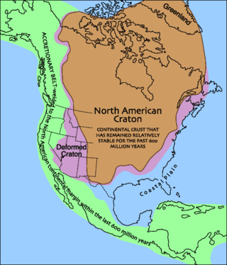
Laurentia or the North American Craton is a large continental craton that forms the ancient geological core of North America. Many times in its past, Laurentia has been a separate continent, as it is now in the form of North America, although originally it also included the cratonic areas of Greenland and also the northwestern part of Scotland, known as the Hebridean Terrane. During other times in its past, Laurentia has been part of larger continents and supercontinents and consists of many smaller terranes assembled on a network of early Proterozoic orogenic belts. Small microcontinents and oceanic islands collided with and sutured onto the ever-growing Laurentia, and together formed the stable Precambrian craton seen today.
The West African Craton (WAC) is one of the five cratons of the Precambrian basement rock of Africa that make up the African Plate, the others being the Kalahari craton, Congo craton, Saharan Metacraton and Tanzania Craton. Cratons themselves are tectonically inactive, but can occur near active margins, with the WAC extending across 14 countries in Western Africa, coming together in the late Precambrian and early Palaeozoic eras to form the African continent. It consists of two Archean centers juxtaposed against multiple Paleoproterozoic domains made of greenstone belts, sedimentary basins, regional granitoid-tonalite-trondhjemite-granodiorite (TTG) plutons, and large shear zones. The craton is overlain by Neoproterozoic and younger sedimentary basins. The boundaries of the WAC are predominantly defined by a combination of geophysics and surface geology, with additional constraints by the geochemistry of the region. At one time, volcanic action around the rim of the craton may have contributed to a major global warming event.

The Tuareg Shield is a geological formation lying between the West African craton and the Saharan Metacraton in West Africa. Named after the Tuareg people, it has complex a geology, reflecting the collision between these cratons and later events. The landmass covers parts of Algeria, Niger and Mali.
The Pharusian Ocean is an ancient ocean that existed from 800 to 635 million years ago, between the break-up of the Rodinia supercontinent and the start of formation of the Gondwana supercontinent.

The Mozambique Belt is a band in the Earth's crust that extends from East Antarctica through East Africa up to the Arabian-Nubian Shield. It formed as a suture between plates during the Pan-African orogeny, when Gondwana was formed.

The Lufilian Arc is part of a system of orogenic belts in southern Africa formed during the Pan-African orogeny, a stage in the formation of the Gondwana supercontinent. It extends across eastern Angola, the Katanga Province of the southern Democratic Republic of the Congo and the northwest of Zambia. The arc is about 800 kilometres (500 mi) long. It has global economic importance owing to its rich deposits of copper and cobalt.
The Zambezi Belt is an area of orogenic deformation in southern Zambia and northern Zimbabwe. It is a segment of a broader belt lying between the Congo Craton and the Kalahari Craton, which also includes the Lufilian Arc and the Damaran Belt. The eastern margin of the belt interacts with the north-south Eastern African orogen.

The East Antarctic Shield or Craton is a cratonic rock body that covers 10.2 million square kilometers or roughly 73% of the continent of Antarctica. The shield is almost entirely buried by the East Antarctic Ice Sheet that has an average thickness of 2200 meters but reaches up to 4700 meters in some locations. East Antarctica is separated from West Antarctica by the 100–300 kilometer wide Transantarctic Mountains, which span nearly 3,500 kilometers from the Weddell Sea to the Ross Sea. The East Antarctic Shield is then divided into an extensive central craton that occupies most of the continental interior and various other marginal cratons that are exposed along the coast.
The Damara orogeny was part of the Pan-African orogeny. The Damara orogeny occurred late in the creation of Gondwana, at the intersection of the Congo and the Kalahari cratons.
The Adamastor Ocean was a "proto-Atlantic" ocean that formed with the break-up of the Rodinia supercontinent c. 780–750 Ma. It separated the Río de la Plata Craton from the Congo Craton. The inversion of the Adamastor Ocean began about 640 Ma with the development of a large back-arc basin along the western margin of the Kalahari Craton, and the ocean closed when Río de la Plata collided with Kalahari about 545 Ma along the sinistral Sierra Ballena Shear Zone. The São Francisco Craton and the Río de la Plata Craton amalgamated 630–620 Ma, closing the Adamastor Ocean on the South American side and forming the Mantiqueira Mountains around 600 Ma.

The Aravalli Mountain Range is a northeast-southwest trending orogenic belt in the northwest part of India and is part of the Indian Shield that was formed from a series of cratonic collisions. The Aravalli Mountains consist of the Aravalli and Delhi fold belts, and are collectively known as the Aravalli-Delhi orogenic belt. The whole mountain range is about 700 km long. Unlike the much younger Himalayan section nearby, the Aravalli Mountains are believed much older and can be traced back to the Proterozoic Eon. They are arguably the oldest geological feature on Earth. The collision between the Bundelkhand craton and the Marwar craton is believed to be the primary mechanism for the development of the mountain range.

