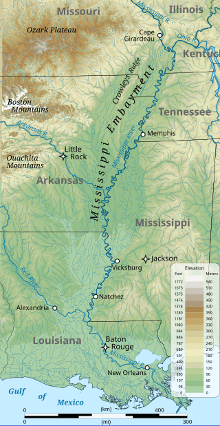
The Mississippi embayment is a physiographic feature in the south-central United States, part of the Mississippi Alluvial Plain. It is essentially a northward continuation of the fluvial sediments of the Mississippi River Delta to its confluence with the Ohio River at Cairo, Illinois. The current sedimentary area was formed in the Cretaceous and early Cenozoic by the filling with sediment of a pre-existing basin. An explanation for the embayment's formation was put forward by Van Arsdale and Cox in 2007: movement of the Earth's crust brought this region over a volcanic "hotspot" in the Earth's mantle causing an upthrust of magma which formed the Appalachian-Ouachita range. Subsequent erosion caused a deep trough that was flooded by the Gulf of Mexico and eventually filled with sediment from the Mississippi River.

The New England hotspot, also referred to as the Great Meteor hotspot and sometimes the Monteregian hotspot, is a volcanic hotspot in the North Atlantic Ocean. It created the Monteregian Hills intrusions in Montreal and Montérégie, the White Mountains intrusions in New Hampshire, the New England and Corner Rise seamounts off the coast of North America, and the Seewarte Seamounts east of the Mid-Atlantic Ridge on the African Plate, the latter of which include its most recent eruptive center, the Great Meteor Seamount. The New England, Great Meteor, or Monteregian hotspot track has been used to estimate the movement of the North American Plate away from the African Plate from the early Cretaceous period to the present using the fixed hotspot reference frame.

The Sirte Basin is a late Mesozoic and Cenozoic triple junction continental rift along northern Africa that was initiated during the late Jurassic Period. It borders a relatively stable Paleozoic craton and cratonic sag basins along its southern margins. The province extends offshore into the Mediterranean Sea, with the northern boundary drawn at the 2,000 meter (m) bathymetric contour. It borders in the north on the Gulf of Sidra and extends south into northern Chad.

Peter Alfred Ziegler was a Swiss geologist, who made contributions to the understanding of the geological evolution of Europe and the North Atlantic borderlands, of intraplate tectonics and of plate tectonic controls on the evolution and hydrocarbon potential of sedimentary basins. Ziegler's career consists of 33 years as exploration geologist with the petroleum industry, 30 of which with Shell, and 20 years of university teaching and research.

The Iberian Plate is a microplate typically grouped with the Eurasian Plate that includes the microcontinent Iberia, Corsica, Sardinia, the Balearic Islands, the Briançonnais zone of the Penninic nappes of the Alps, and the portion of Morocco north of the High Atlas Mountains. The Iberian plate is a part of the Eurasian plate.
Logone-Birni is a town and commune in Cameroon. The town lies on the left (west) bank of the Logone River which at this point forms the state boundary between Cameroon and Chad. It is the capital of the Kotoko people, whose two other principal cities are Kousséri and Goulfey.

The White Nile rift is one of several rifts in central Sudan running in a NW direction and terminating in the Central African Shear Zone. The rift is a Cretaceous/Tertiary structure that has similar tectonic characteristics to the Southern Sudan Rift, Blue Nile rift and Atbara rift. These rifts follow similar trends, and terminate in a line at their northwestern ends. Probably this line is an extension of the Central African Shear Zone through the Sudan.

The Central African Shear Zone (CASZ) is a wrench fault system extending in an ENE direction from the Gulf of Guinea through Cameroon into Sudan. The structure is not well understood. As of 2008, there was still no general agreement about how the individual shears along the lineament link up.
The Blue Nile rift is a major geological structure in the Sudan, a rift with a NW trend that terminates on the Central African Shear Zone. It was formed through crustal extension during the break-up of Gondwana.
The Benue Trough is a major geological structure underlying a large part of Nigeria and extending about 1,000 km northeast from the Bight of Benin to Lake Chad. It is part of the broader West and Central African Rift System.
A transfer zone in geology is an area where deformational strain is transferred from one structural element to another typically from fault to fault in rift systems. Therefore, listric faults and monoclinal folds in the hanging wall are typical structures linked by transfer zones; however, complexities do exist. The terms interbasin and intrabasin transfer zones have been proposed to delineate the magnitude of the transfer zone. Transfer zones can be described according to the fault dip directions; synthetic or conjugate and according to their deformation style; convergent or divergent. Transfer zones can be farther identified by its maturity or ; whether the major fault relationship is approaching, overlapping, collateral or collinear. Since transfer zones are normally found in extensional settings many studies have been done within the East African rift system and the Gulf of Suez rift system. Transfer zones have also played a role in hydrocarbon exploration and extraction within the Albertine graben.

The East Antarctic Shield or Craton is a cratonic rock body that covers 10.2 million square kilometers or roughly 73% of the continent of Antarctica. The shield is almost entirely buried by the East Antarctic Ice Sheet that has an average thickness of 2200 meters but reaches up to 4700 meters in some locations. East Antarctica is separated from West Antarctica by the 100–300 kilometer wide Transantarctic Mountains, which span nearly 3,500 kilometers from the Weddell Sea to the Ross Sea. The East Antarctic Shield is then divided into an extensive central craton that occupies most of the continental interior and various other marginal cratons that are exposed along the coast.

The North Sea is part of the Atlantic Ocean in northern Europe. It is located between Norway and Denmark in the east, Scotland and England in the west, Germany, the Netherlands, Belgium and France in the south.

The North German Basin is a passive-active rift basin located in central and west Europe, lying within the southeasternmost portions of the North Sea and the southwestern Baltic Sea and across terrestrial portions of northern Germany, Netherlands, and Poland. The North German Basin is a sub-basin of the Southern Permian Basin, that accounts for a composite of intra-continental basins composed of Permian to Cenozoic sediments, which have accumulated to thicknesses around 10–12 kilometres (6–7.5 mi). The complex evolution of the basin takes place from the Permian to the Cenozoic, and is largely influenced by multiple stages of rifting, subsidence, and salt tectonic events. The North German Basin also accounts for a significant amount of Western Europe's natural gas resources, including one of the world's largest natural gas reservoir, the Groningen gas field.

The Kutai sedimentary basin extends from the central highlands of Borneo, across the eastern coast of the island and into the Makassar Strait. With an area of 60,000 km2, and depths up to 15 km, the Kutai is the largest and deepest Tertiary age basin in Indonesia. Plate tectonic evolution in the Indonesian region of SE Asia has produced a diverse array of basins in the Cenozoic. The Kutai is an extensional basin in a general foreland setting. Its geologic evolution begins in the mid Eocene and involves phases of extension and rifting, thermal sag, and isostatic subsidence. Rapid, high volume, sedimentation related to uplift and inversion began in the Early Miocene. The different stages of Kutai basin evolution can be roughly correlated to regional and local tectonic events. It is also likely that regional climate, namely the onset of the equatorial ever wet monsoon in early Miocene, has affected the geologic evolution of Borneo and the Kutai basin through the present day. Basin fill is ongoing in the lower Kutai basin, as the modern Mahakam River delta progrades east across the continental shelf of Borneo.
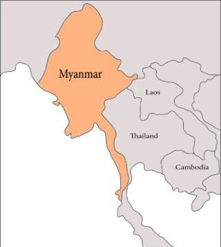
The geology of Myanmar is shaped by dramatic, ongoing tectonic processes controlled by shifting tectonic components as the Indian plate slides northwards and towards Southeast Asia. Myanmar spans across parts of three tectonic plates separated by north-trending faults. To the west, a highly oblique subduction zone separates the offshore Indian plate from the Burma microplate, which underlies most of the country. In the center-east of Myanmar, a right lateral strike slip fault extends from south to north across more than 1,000 km (620 mi). These tectonic zones are responsible for large earthquakes in the region. The India-Eurasia plate collision which initiated in the Eocene provides the last geological pieces of Myanmar, and thus Myanmar preserves a more extensive Cenozoic geological record as compared to records of the Mesozoic and Paleozoic eras. Myanmar is physiographically divided into three regions: the Indo-Burman Range, Myanmar Central Belt and the Shan Plateau; these all display an arcuate shape bulging westwards. The varying regional tectonic settings of Myanmar not only give rise to disparate regional features, but they also foster the formation of petroleum basins and a diverse mix of mineral resources.
The geology of Brazil includes very ancient craton basement rock from the Precambrian overlain by sedimentary rocks and intruded by igneous activity, as well as impacted by the rifting of the Atlantic Ocean.

The Junggar Basin, also known as the Dzungarian Basin or Zungarian Basin, is one of the largest sedimentary basins in Northwest China. It is located in Dzungaria in northern Xinjiang, and enclosed by the Tarbagatai Mountains of Kazakhstan in the northwest, the Altai Mountains of Mongolia in the northeast, and the Heavenly Mountains in the south. The geology of Junggar Basin mainly consists of sedimentary rocks underlain by igneous and metamorphic basement rocks. The basement of the basin was largely formed during the development of the Pangea supercontinent during complex tectonic events from Precambrian to late Paleozoic time. The basin developed as a series of foreland basins – in other words, basins developing immediately in front of growing mountain ranges – from Permian time to the Quaternary period. The basin's preserved sedimentary records show that the climate during the Mesozoic era was marked by a transition from humid to arid conditions as monsoonal climatic effects waned. The Junggar basin is rich in geological resources due to effects of volcanism and sedimentary deposition. According to Guinness World Records it is a land location remotest from open sea with great-circle distance of 2,648 km from the nearest open sea at 46°16′8″N86°40′2″E.
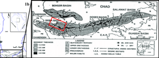
The Doba Basin is a sedimentary basin located in Chad and is part of the Central African rift system. This basin contains up to 10 km of non-marine sediments which record the complex tectonic and climatic evolution of the region from the Early Cretaceous Period to the present. These basins were originally identified using gravity data, but three decades of subsequent exploration activity has significantly increased understanding of the basins evolution. Interpretations differ significantly from earlier models that invoke widespread misinformation. The basins were sites of extension on a trans-African shear zone beginning in the Neocomian.

