The geography of Guinea-Bissau is that of low coastal plains bordering the Atlantic Ocean. The country borders Senegal in the north and Guinea in the southeast.
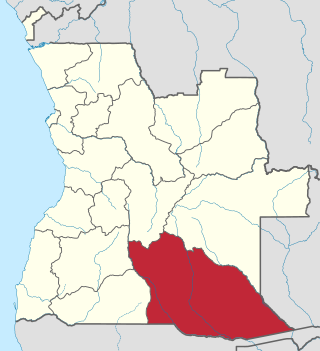
Cuando Cubango is a province of Angola and it has an area of 199,049km2 and a population of 534,002 in 2014. Menongue is the capital of the province. The governor of the province is José Martins, who was appointed governor in November 2021.

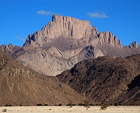
The Hoggar Mountains are a highland region in the central Sahara in southern Algeria, along the Tropic of Cancer. The mountains cover an area of approximately 550,000 km.
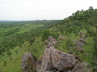
The Aïr Mountains or Aïr Massif is a triangular massif, located in northern Niger, within the Sahara. Part of the West Saharan montane xeric woodlands ecoregion, they rise to more than 1,800 m (5,900 ft) and extend over 84,000 km2 (32,000 sq mi). Lying in the midst of desert north of the 17th parallel, the Aïr plateau, with an average altitude between 500 and 900 m, forms an island of Sahel climate which supports a wide variety of life, many pastoral and farming communities, and dramatic geological and archaeological sites. There are notable archaeological excavations in the region that illustrate the prehistoric past of this region. The endangered African wild dog once existed in this region, but may now be extirpated due to human population pressures in this region.

Gonarezhou National Park is a national park located in southeastern Zimbabwe. It is situated in a relatively remote corner of Masvingo Province, south of Chimanimani along the Mozambique border. Owing to its vast size, rugged terrain and its location away from main tourist routes, large tracts of Gonarezhou remain pristine wilderness.

The Tanezrouft is a natural region located along the borders of Algeria and Mali, west of the Hoggar Mountains. Along with the Libyan Desert it is one of the most desolate and most arid parts of the Sahara Desert. This area has no permanent residents and is known for its soaring temperatures and scarce access to crucial resources: water and food. Due to this, it is commonly referred to as the "land of terror".

Arli National Park, often called Arly, is a national park located in Tapoa Province, southeastern Burkina Faso. It adjoins Benin's Pendjari National Park in the south and the Singou Reserve in the west.

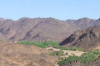
Kel Ahaggar is a Tuareg confederation inhabiting the Hoggar Mountains in Algeria. The confederation is believed to have been founded by the Tuareg matriarch Tin Hinan, whose monumental tomb is located at Abalessa. The official establishment is dated to around 1750. It has been largely defunct since 1977, when it was terminated by the Algerian government.
Old Oyo National Park is one of the national parks of Nigeria, located across northern Oyo State and southern Kwara State, Nigeria. The park is 2,512 km2 of land in northern Oyo state, south west Nigeria, at latitude 8° 15’ and 9° 00’N and longitude 3° 35’ and 4° 42’ E. The location has inevitably placed the park at a vantage position of abundance land area as well as diverse wildlife and cultural/historical settings. Eleven local government areas out of which ten fall within Oyo State and one in Kwara State surround it. The Administrative Head Office is located in Oyo, Isokun area along Oyo-Iseyin road, where necessary information and booking could be made. The landscaping and organized space within the large yard has made the facility very endearing to the public. It is rich in plant and animal resources including buffaloes, bushbuck and a variety of birds. The park is easily accessible from southwestern and northwestern Nigeria. The nearest cities and towns adjoining Old Oyo National Park include Saki, Iseyin, Igboho, Sepeteri, Tede, Kishi and Igbeti which have their own commercial and cultural attractions for tourism.
The Togo Mountains is a mountain range which stretches across the central region of the West African country of Togo and across the eastern and western borders of that country into Ghana and Benin. In Ghana, the range is also known as the Akwapim Hills, and in Benin it is also known as the Atakora Mountains. Part of the range is associated with the country of Niger, where the W National Park is found. The African wild dog, Lycaon pictus, was historically found in this region but may now be extirpated from this locale.
Finca'a is a town in western Oromia. Located in the Horo Guduru Welega Zone of the Oromia, Ethiopia. This town has a latitude and longitude of 09°54′N37°27′E with an altitude of 2302 meters above sea level. Finicha'a hosts an airport which consists of an unpaved airstrip about 1480 meters in length. It is the administrative center of Abay Chomen woreda.
Bouba Njida National Park is a national park of Cameroon. A total of 23 antelope species occur in the park. The painted hunting dog, Lycaon pictus, had been observed in Bouba Njida National Park at the start of the 21st century. This population of the endangered canid is one of the few that remained in Cameroon as of the year 2000.
Tsumkwe is a settlement in the Otjozondjupa Region of Namibia and the district capital of the Tsumkwe electoral constituency.
Filtu is the capital city of '"Liben Zone"' Filtu(also known as Gindiyeer) is a town in southern Ethiopia. Located in the Liben Zone of the Somali Region, it has a latitude and longitude of 4°58′N40°23′E with an elevation of 3,150 meters above sea level. It is the administrative center of Filtu woreda. During the Italian occupation, a road 115 kilometers in length to Negele Boran was maintained but not paved.

Dinder National Park is a national park and biosphere reserve in eastern Sudan, and is connected to Ethiopia's Alitash National Park.

The Harenna Forest is a montane tropical evergreen forest in Ethiopia's Bale Mountains. The forest covers the southern slope of the mountains, extending from 1450 to 3200 meters elevation. The Bale Mountains are in Ethiopia's Oromia Region, and form the southwestern portion of the Ethiopian Highlands.
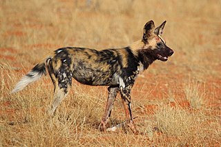
The African wild dog, also called the painted dog or Cape hunting dog, is a wild canine which is a native species to sub-Saharan Africa. It is the largest wild canine in Africa, and the only extant member of the genus Lycaon, which is distinguished from Canis by dentition highly specialised for a hypercarnivorous diet, and by a lack of dewclaws. It is estimated that about 6,600 adults live in 39 subpopulations that are all threatened by habitat fragmentation, human persecution, and outbreaks of disease. As the largest subpopulation probably comprises fewer than 250 individuals, the African wild dog has been listed as endangered on the IUCN Red List since 1990.

The Sanetti Plateau is a major plateau of the Ethiopian Highlands, in the Oromia Region of Ethiopia. The plateau is the highest part of the Bale Mountains, and is located within Bale Mountains National Park.

The Tuareg Shield is a geological formation lying between the West African craton and the Saharan Metacraton in West Africa. Named after the Tuareg people, it has complex a geology, reflecting the collision between these cratons and later events. The landmass covers parts of Algeria, Niger and Mali.
Harena Buluk is one of the woredas in the Oromia Region of Ethiopia. It was part of former Menna Angetu woreda. It is part of the Bale Zone. Harena Buluk woreda is bordered on the south by Meda Welabu, on the north by Goba, on the west by Nensebo, on the northwest by Adaba, and on the east by [[Delo Menna, Oromia (woreda). The administrative center for the woreda is Angetu.