
In geology, a graben is a depressed block of the crust of a planet or moon, bordered by parallel faults.
An aulacogen is a failed arm of a triple junction. Aulacogens are a part of plate tectonics where oceanic and continental crust is continuously being created, destroyed, and rearranged on the Earth’s surface. Specifically, aulacogens are a rift zone, where new crust is formed, that is no longer active.

In geology, a rift is a linear zone where the lithosphere is being pulled apart and is an example of extensional tectonics.

Western Bahr el Ghazal is a state in South Sudan. It has an area of 93,900 km2 (36,255 sq mi) and is the least populous state in South Sudan, according to the controversial Sudanese census conducted in 2008. It is part of the Bahr el Ghazal region. Its capital is Wau. The state shared international borders with Sudan to the north and the Central African Republic to the west. The portion now occupied by Raga County is the southern part of the historical region known as "Dar Fertit".

Oseberg is an offshore oil field with a gas cap in the North Sea located 140 km (87 mi) northwest of the city of Bergen on the southwestern coast of Norway. The field, which is 25 km long by 7 km wide, was discovered in 1979 and its development is known to be one of the significant milestones in emergence of Norway's independent oil and gas industry. The Oseberg field was named after Oseberg ship, one of Norway's most significant archeological discoveries. The ancient Viking ship from the early 9th century was discovered in a 1904 historical excavation of a burial mound at the Oseberg Farm, south of Oslo.
Extensional tectonics is concerned with the structures formed by, and the tectonic processes associated with, the stretching of a planetary body's crust or lithosphere.

The Newark Basin is a sediment-filled rift basin located mainly in northern New Jersey but also stretching into south-eastern Pennsylvania and southern New York. It is part of the system of Eastern North America Rift Basins.

The Sirte Basin is a late Mesozoic and Cenozoic triple junction continental rift along northern Africa that was initiated during the late Jurassic Period. It borders a relatively stable Paleozoic craton and cratonic sag basins along its southern margins. The province extends offshore into the Mediterranean Sea, with the northern boundary drawn at the 2,000 meter (m) bathymetric contour. It borders in the north on the Gulf of Sidra and extends south into northern Chad.

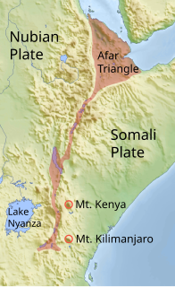
The Afar Triple Junction is located along a divergent plate boundary dividing the Nubian, Somali, and Arabian plates. This area is considered a present-day example of continental rifting leading to seafloor spreading and producing an oceanic basin. Here, the Red Sea Rift meets the Aden Ridge and the East African Rift. It extends a total of 6,500 kilometers (4,000 mi) in three arms from the Afar Triangle to Mozambique.
The Upper Rhine Plain, Rhine Rift Valley or Upper Rhine Graben is a major rift, about 350-kilometre-long (220 mi) and on average 50-kilometre-wide (31 mi), between Basel in the south and the cities of Frankfurt/Wiesbaden in the north. Its southern section straddles the France–Germany border. It forms part of the European Cenozoic Rift System, which extends across Central Europe. The Upper Rhine Graben formed during the Oligocene, as a response to the evolution of the Alps to the south. It remains active to the present day. Today, the Rhine Rift Valley forms a downfaulted trough through which the river Rhine flows.

The Ceraunius Fossae are a set of fractures in the northern Tharsis region of Mars. They lie directly south of the large volcano Alba Mons and consist of numerous parallel faults and tension cracks that deform the ancient highland crust. In places, younger lava flows cover the fractured terrain, dividing it into several large patches or islands. They are found in the Tharsis quadrangle.

The European Cenozoic Rift System (ECRIS) is a 1,100 km (680 mi) long system of rifts formed in the foreland of the Alps as the lithosphere responded to the effects of the Alpine and Pyrenean orogenies. The system began to form during the Late Eocene and parts remain seismically active today and are responsible for most of the larger earthquakes in Europe, north of the Alps.

The Central African Shear Zone (CASZ) is a wrench fault system extending in an ENE direction from the Gulf of Guinea through Cameroon into Sudan. The structure is not well understood. As of 2008, there was still no general agreement about how the individual shears along the lineament link up.

The Blue Nile rift is a major geological formation in the Sudan, a rift with a NW trend that terminates on the Central African Shear Zone. It was formed through crustal extension during the break-up of Gondwana.
The 2002 Kalehe earthquake occurred on October 24 at 06:08 UTC. This earthquake had a magnitude 6.2, and the epicenter was located in Democratic Republic of the Congo, near Lake Kivu. Eight people were reported dead. Building damage was reported in Goma, Lwiro, Kalehe, and Mugeri. The seismicity, volcanism, and uplift in the basin of Lake Kivu delimits the rift of a tectonic plate. Lake Kivu belongs to the western branch of the East African Rift System (EARS). The western branch is usually divided into several segments, and Lake Kivu belongs to the northern segment.
The Gregory Rift is the eastern branch of the East African Rift fracture system. The rift is being caused by the separation of the Somali plate from the Nubian plate, driven by a thermal plume. Although the term is sometimes used in the narrow sense of the Kenyan Rift, the larger definition of the Gregory Rift is the set of faults and grabens extending southward from the Gulf of Aden through Ethiopia and Kenya into Northern Tanzania, passing over the local uplifts of the Ethiopian and Kenyan domes. Ancient fossils of early hominins, the ancestors of humans, have been found in the southern part of the Gregory Rift.
A transfer zone in geology is an area where deformational strain is transferred from one structural element to another typically from fault to fault in rift systems. Therefore, listric faults and monoclinal folds in the hanging wall are typical structures linked by transfer zones; however, complexities do exist. The terms interbasin and intrabasin transfer zones have been proposed to delineate the magnitude of the transfer zone. Transfer zones can be described according to the fault dip directions; synthetic or conjugate and according to their deformation style; convergent or divergent. Transfer zones can be farther identified by its maturity or ; whether the major fault relationship is approaching, overlapping, collateral or collinear. Since transfer zones are normally found in extensional settings many studies have been done within the East African rift system and the Gulf of Suez rift system. Transfer zones have also played a role in hydrocarbon exploration and extraction within the Albertine graben.

Devana Chasma is a weak extensional rift zone on Venus, with a length of 4000 km, a width of 150–250 km, and a depth reaching 5 km. Most of the faults are facing north–south. The rift is located in Beta Regio, a 3000 km rise created by volcanic activity. Mantle plumes rising from the bottom are the reason behind the formation of the rift zone. The slow extension rates in the rift may be driven by the same reason.

The Taranaki Basin is an onshore-offshore Cretaceous rift basin on the West Coast of New Zealand. Development of rifting was the result of extensional stresses during the breakup of Gondwanaland. The basin later underwent fore-arc and intra-arc basin development, due to the subduction of the Pacific Plate under the Australian Plate at the Hikurangi Subduction System. The basin covers approximately 100,000 km2 of which the majority is offshore. The basin contains mostly marine sediment, with significant terrestrial sediment from the Late Cretaceous to the Eocene. The majority of New Zealand's oil and gas production occurs within the basin, with over 400 wells and approximately 20 oil and gas fields being drilled.
The South Lokichar Basin is a Cenozoic sedimentary basin in Kenya. It is part of the East African Rift system, although it is no longer active. Since 2012 it has been the location of a series of oil discoveries by Tullow Oil and its partners.
