Great Escarpment, Southern Africa

Last updated
The Escarpment and the Drakensberg.jpg
A map of South Africa shows the central plateau edged by the Great Escarpment and its relationship to the Cape Fold Mountains in the south. The portion of the Great Escarpment shown in red is officially known as the Drakensberg, although most South Africans think of the Drakensberg as only that portion of the escarpment that forms the border between KwaZulu-Natal and Lesotho. Here the escarpment rises to its greatest height of more than 3,000 metres (9,800 ft).
South Africa sat.jpg
Compared to the preceding map, the Great Escarpment can be identified in this satellite image of South Africa

The Great Escarpment is a major topographical feature in Africa that consists of steep slopes from the high central Southern African plateau [1] downward in the direction of the oceans that surround southern Africa on three sides. [2] [3] While it lies predominantly within the borders of South Africa, in the east the escarpment extends northward to form the border between Mozambique and Zimbabwe, continuing on beyond the Zambezi river valley to form the Muchinga Escarpment in eastern Zambia. [4] [5] In the west, it extends northward into Namibia and Angola. [4] [6] It is the combination of this escarpment and the aridity of Southern Africa that leads to the lack of navigable rivers in South Africa.

Contents

Different names are applied to different stretches of the Great Escarpment, the most well-known section being the Drakensberg (diagram on the right). The Schwarzrand and edge of the Khomas Highland in Namibia, as well as the Serra da Chela in Angola, are also well-known names.

Geological origins

About 180 million years ago, a mantle plume under southern Gondwana caused bulging of the continental crust in the area that would later become southern Africa. [2] Within 10–20 million years, rift valleys formed on either side of the central bulge and flooded to become the proto-Atlantic Ocean and proto-Indian Ocean more or less along the present southern African coastline and separating the Southern Cape from the Falkland Plateau. [2] [3] The stepped, steep walls of these rift valleys formed escarpments that surrounded the newly formed Southern African subcontinent. [2]

During the past 20 million years, southern Africa has experienced further massive uplifting, especially in the east, with the result that most of the plateau lies above 1,000 m (3,300 ft) despite extensive erosion. The plateau is tilted such that it is highest in the east and slopes gently downward toward the west and south. Typically, the elevation of the edge of the eastern escarpments is in excess of 2,000 m (6,600 ft). It reaches its highest point of over 3,000 m (9,800 ft) where the escarpment forms part of the international border between Lesotho and the South African province of KwaZulu-Natal. [1] [2]

With the widening of the Atlantic, Indian, and Southern oceans, southern Africa became tectonically quiescent. Earthquakes rarely occur in the region, and there has been no volcanic or orogenic activity for approximately 50 million years. [7] An almost uninterrupted period of erosion continues to the present, removing layers many kilometers thick from the surface of the plateau and moving the present position of the escarpment approximately 150 kilometres (93 mi) inland from the original fault lines that formed the walls of the rift valley along the coastline during the break-up of Gondwana. [2] [8] Consequently, a thick layer of marine sediment was deposited onto the continental shelf (the lower steps of the original rift valley walls) that surrounds the subcontinent, creating the present-day coastal plain. [3] [2] [9] [8] The rate of the erosion of the escarpment in the Drakensberg region is said to average 1.5 m (5 ft) per 1000 years, or 1.5 millimetres (116 in) per year. [8]

An approximate SW-NE cross section through South Africa with the Cape Peninsula (with Table Mountain) on the far left, and northeastern KwaZulu-Natal on the right is diagrammatic, and only roughly to scale. It shows the major geological structures (coloured layers) that dominate the southern and eastern parts of the country, as well as the relationship between the Central Plateau, the Cape Fold mountains, and the Drakensberg escarpment. The southwestern escarpment (the Roggeberg escarpment) is clearly visible on the left, but is not labelled. The significance and origin of the geological layers can be found under the headings "Karoo Supergroup" and "Cape Supergroup" SW-NE geological cross section through South Africa.jpg
An approximate SW-NE cross section through South Africa with the Cape Peninsula (with Table Mountain) on the far left, and northeastern KwaZulu-Natal on the right is diagrammatic, and only roughly to scale. It shows the major geological structures (coloured layers) that dominate the southern and eastern parts of the country, as well as the relationship between the Central Plateau, the Cape Fold mountains, and the Drakensberg escarpment. The southwestern escarpment (the Roggeberg escarpment) is clearly visible on the left, but is not labelled. The significance and origin of the geological layers can be found under the headings "Karoo Supergroup" and "Cape Supergroup"

Because of erosion throughout most of the Mesozoic and Cenozoic eras, none of the plateau's surface rocks (except the Kalahari sands) are younger than 180 million years. [2] [10] The youngest rocks that remain cap the plateau in Lesotho and form the steep sides of the Great Escarpment in this region. These are the Clarens Formation laid down under desert conditions about 200 million years ago, topped by a 1,600 m (5,200 ft) thick layer of lava that erupted and covered most of southern Africa, and indeed large parts of Gondwana, approximately 180 million years ago. [2] [3] [11]

Erosional retreat means that the rocks exposed on the coastal plain are, with very few and small exceptions, older than those that cap the escarpment. The rocks found in the Lowveld below the Mpumalanga portion of the Great Escarpment are more than 3 billion years old. [10] As the escarpment retreated inland, the Cape Fold Mountains that had formed 150 million years earlier and been buried under sediments from the Himalaya-sized range of Gondwana mountains were gradually re-exposed. [12] Being composed of erosion-resistant quartzitic sandstone, they remained as the less resistant overlying sediments were removed, ultimately to form the parallel formations that protrude from the coastal plain of the south and southwest Cape. [2] In the main, the rocks of the KwaZulu-Natal Midlands belong to the Beaufort and Ecca Groups (of the Karoo Supergroup), aged 220–310 million years.

The eastern portion of the Great Escarpment goes as far north as Tzaneen at approximately the 22° S parallel, and from there veers west to Potgietersrust, where it is known as the Strydpoort Mountains. [1] [13] The absence of the Great Escarpment for approximately 450 km (280 mi) to the north of Tzaneen (to reappear on the border between Zimbabwe and Mozambique in the Chimanimani Mountains) is due to a failed westerly branch of the main rift that caused Antarctica to start drifting away from southern Africa during the breakup of Gondwana about 150 million years ago. The lower Limpopo River and Save River drain into the Indian Ocean through what remains of this relict incipient rift valley, which now forms part of the South African Lowveld. [9]

Appearance

This is a stylized illustration of the Southern African Great Escarpment, based particularly on its appearance in the Great Karoo, where thick erosion resistant dolerite sills (represented by the thick black lines in the diagram) generally form the upper, sharp edge of the escarpment; in other parts of the escarpment hard erosion-resistant geological layers similarly form the upper, abrupt edge (see text); note the island remnants of the earlier extent of the plateau on the plain below the escarpment, left behind as the escarpment has gradually eroded farther inland The Great Escarpment.jpg
This is a stylized illustration of the Southern African Great Escarpment, based particularly on its appearance in the Great Karoo, where thick erosion resistant dolerite sills (represented by the thick black lines in the diagram) generally form the upper, sharp edge of the escarpment; in other parts of the escarpment hard erosion-resistant geological layers similarly form the upper, abrupt edge (see text); note the island remnants of the earlier extent of the plateau on the plain below the escarpment, left behind as the escarpment has gradually eroded farther inland
A view of the Mpumalanga Drakensberg portion of the Great Escarpment, from God's Window, near Graskop looking south, shows the hard erosion-resistant layer that forms the upper edge of the escarpment that consists of flat-lying quartzite belonging to the Black Reef Formation, which also forms the Magaliesberg mountains near Pretoria. South Africa-Mpumalanga-Gods Window002.jpg
A view of the Mpumalanga Drakensberg portion of the Great Escarpment, from God's Window, near Graskop looking south, shows the hard erosion-resistant layer that forms the upper edge of the escarpment that consists of flat-lying quartzite belonging to the Black Reef Formation, which also forms the Magaliesberg mountains near Pretoria.

The eastern portion of the Great Escarpment within the borders of South Africa (see the accompanying map, above) is referred to as the Drakensberg (meaning "Dragon Mountains"). [1] [14] The Limpopo, Mpumalanga and Lesotho Drakensberg have hard erosion-resistant upper surfaces and therefore have a very high and rugged appearance, combining steep-sided blocks and pinnacles. The KwaZulu-NatalFree State Drakensberg escarpment is composed of softer rocks and therefore has a more rounded, softer appearance from below. Generally, the top of the Escarpment is almost table-top flat and smooth, even in Lesotho. The "Lesotho Mountains" are formed away from the Drakensberg escarpment by erosion gulleys that turn into deep valleys that contain the tributaries that flow into the Orange River. There are so many of these tributaries that it gives the Lesotho Highlands a very rugged mountainous appearance, both from the ground and from the air.

Along the southern extent of the central plateau some of the thicker, hard, erosion-resistant dolerite sills form large parts of the upper edge of the escarpment (see illustration on the right), but where the sills are thinner or absent then, like the portion of the Drakensberg between KwaZulu-NatalFree State, the escarpment is composed of softer rocks, aged between 250 and 300 million years old. [10] This means that in these regions the scarp has a more rounded appearance, or has eroded away to such an extent that the scarp may no longer be evident (for instance along the route taken by the N1 highway between Beaufort West, below the escarpment, and just beyond Three Sisters on the way to Richmond or Victoria West, on the plateau; and also where the Orange River has eroded a broad valley through the escarpment in the west before it flows into the Atlantic Ocean). Along most of its extent, however, it forms a 400–800 m high mountain-like ridge that roads into the interior have to negotiate, sometimes up steep winding passes, such as the Burke's, Vanrhyns, Bloukrans, Gannaga, Ouberg, Verlatekloof, Teekloof, Molteno, Goliatskraal, Daggaboersnek, Katberg, Nico Malan, and Barkly passes. Nevertheless, the escarpment to the south and west of the plateau lacks the grandeur of the Mpumalaga and Lesotho Drakensberg, on the one hand, and the extremely rugged, intricately-folded, ranges of Cape Fold Mountains that run parallel to the coast on the seaward side of the Great Escarpment. (The parallel ranges of mountains, to the south of the escarpment, can clearly be seen on the accompanying satellite image of South Africa, especially when compared to the diagram on the left, which shows the course of the Great Escarpment.) The fold mountains were formed about 330 million years ago, [2] [3] and therefore pre-date the formation of the escarpment by nearly 200 million years. The two events are geologically unrelated to one another. They also represent two very different geological processes: the Great Escarpment resulted from rifting, and the tearing apart of the Gondwana super-continent, whereas the Cape Fold Mountains resulted from the collision of tectonic plates, during the assembly of Gondwana, in the same way that the Andes Mountains in South America are being formed today.

The Cape Fold Mountains have been re-exposed by erosion of the coastal plain below the Great Escarpment (see "Geological origin", above), after having been covered by sediments originating from an even higher and more extensive range of mountains, comparable to the Himalayas, that developed during the assembly of Gondwana to the south of the present African continent, on the portion of Gondwana called the "Falkland Plateau", the remnants of which are at present located far to the southwest of southern Africa close to southern tip of South America. [2]

See also

Related Research Articles

<span class="mw-page-title-main">Geography of South Africa</span>

South Africa occupies the southern tip of Africa, its coastline stretching more than 2,850 kilometres from the desert border with Namibia on the Atlantic (western) coast southwards around the tip of Africa and then northeast to the border with Mozambique on the Indian Ocean. The low-lying coastal zone is narrow for much of that distance, soon giving way to a mountainous escarpment that separates the coast from the high inland plateau. In some places, notably the province of KwaZulu-Natal in the east, a greater distance separates the coast from the escarpment. Although much of the country is classified as semi-arid, it has considerable variation in climate as well as topography. The total land area is 1,220,813 km2 (471,359 sq mi). It has the 23rd largest Exclusive Economic Zone of 1,535,538 km2 (592,875 sq mi).

<span class="mw-page-title-main">KwaZulu-Natal</span> Province in South Africa

KwaZulu-Natal is a province of South Africa that was created in 1994 when the Zulu bantustan of KwaZulu and Natal Province were merged. It is located in the southeast of the country, with a long shoreline on the Indian Ocean and sharing borders with three other provinces and the countries of Mozambique, Eswatini and Lesotho. Its capital is Pietermaritzburg, and its largest city is Durban. It is the second-most populous province in South Africa, with slightly fewer residents than Gauteng.

<span class="mw-page-title-main">Drakensberg</span> Mountain range in South Africa

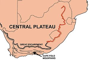
The Drakensberg is the eastern portion of the Great Escarpment, which encloses the central Southern African plateau. The Great Escarpment reaches its greatest elevation – 2,000 to 3,482 metres within the border region of South Africa and Lesotho.

<span class="mw-page-title-main">Lebombo Mountains</span>

The Lebombo Mountains, also called Lubombo Mountains, are an 800 km-long (500 mi), narrow range of mountains in Southern Africa. They stretch from Hluhluwe in KwaZulu-Natal in the south to Punda Maria in the Limpopo Province in South Africa in the north. Parts of the mountain range are also found in Mozambique and Eswatini.

<span class="mw-page-title-main">Karoo</span> Semi-desert region in South Africa

The Karoo is a semi-desert natural region of South Africa. No exact definition of what constitutes the Karoo is available, so its extent is also not precisely defined. The Karoo is partly defined by its topography, geology and climate, and above all, its low rainfall, arid air, cloudless skies, and extremes of heat and cold. The Karoo also hosted a well-preserved ecosystem hundreds of million years ago which is now represented by many fossils.

<span class="mw-page-title-main">Highveld</span> Geographic region of the South African inland plateau

The Highveld is the portion of the South African inland plateau which has an altitude above roughly 1500 m, but below 2100 m, thus excluding the Lesotho mountain regions to the south-east of the Highveld. It is home to some of the country's most important commercial farming areas, as well as its largest concentration of metropolitan centres, especially the Gauteng conurbation, which accommodates one-third of South Africa's population.

Mont-aux-Sources is a mountain in Southern Africa, forming one of the highest portions of the Drakensberg Range. It is mostly within Lesotho, with parts in the KwaZulu-Natal and Free State provinces of South Africa.

<span class="mw-page-title-main">Sani Pass</span> Mountain pass in South Africa and Lesotho

Sani Pass is a mountain pass located in the West of KwaZulu-Natal, South Africa on the road between Himeville, KwaZulu-Natal and Mokhotlong, Lesotho. The pass traverses the Great Escarpment of southern Africa in its highest region, the Drakensberg Mountains, which reach an elevation of over 3,000 meters.

<span class="mw-page-title-main">Karoo National Park</span> Wildlife reserve in the Great Karoo area of the Western Cape, South Africa near Beaufort West

The Karoo National Park is a wildlife reserve in the Great Karoo area of the Western Cape, South Africa near Beaufort West. This semi-desert area covers an area of 750 square kilometres (290 sq mi). The Nuweveld portion of the Great Escarpment runs through the Park. It is therefore partly in the Lower Karoo, at about 850 m above sea level, and partly in the Upper Karoo at over 1300 m altitude.

<span class="mw-page-title-main">Karoo Supergroup</span> Widespread Mesozoic stratigraphic unit in southern Africa

The Karoo Supergroup is the most widespread stratigraphic unit in Africa south of the Kalahari Desert. The supergroup consists of a sequence of units, mostly of nonmarine origin, deposited between the Late Carboniferous and Early Jurassic, a period of about 120 million years.

<span class="mw-page-title-main">Cape Fold Belt</span> Late Paleozoic fold and thrust belt in southwestern South Africa

The Cape Fold Belt is a fold and thrust belt of late Paleozoic age, which affected the sequence of sedimentary rock layers of the Cape Supergroup in the southwestern corner of South Africa. It was originally continuous with the Ventana Mountains near Bahía Blanca in Argentina, the Pensacola Mountains, the Ellsworth Mountains and the Hunter-Bowen orogeny in eastern Australia. The rocks involved are generally sandstones and shales, with the shales persisting in the valley floors while the erosion resistant sandstones form the parallel ranges, the Cape Fold Mountains, which reach a maximum height of 2325 m at Seweweekspoortpiek.

<span class="mw-page-title-main">Table Mountain Sandstone</span> Group of rock formations within the Cape Supergroup sequence of rocks

Table Mountain Sandstone (TMS) is a group of rock formations within the Cape Supergroup sequence of rocks. Although the term "Table Mountain Sandstone" is still widely used in common parlance, the term TMS is no longer formally recognized; the correct name is the "Peninsula Formation Sandstone", which is part of the Table Mountain Group. The designation "Table Mountain Sandstone" will, however, in deference to the title, continue to be used in the rest of this article. The name is derived from the famous landmark in Cape Town, Table Mountain.

<span class="mw-page-title-main">Stormberg Group</span> Triassic/Jurassic geological group in the Karoo Supergroup in South Africa

The Stormberg Group is one of the four geological groups that comprises the Karoo Supergroup in South Africa. It is the uppermost geological group representing the final phase of preserved sedimentation of the Karoo Basin. The Stormberg Group rocks are considered to range between Lower Triassic (Olenekian) to Lower Jurassic (Pliensbachian) in age. These estimates are based on means of geological dating including stratigraphic position, lithostratigraphic and biostratigraphic correlations, and palynological analyses.

<span class="mw-page-title-main">Matatiele Local Municipality</span> Local municipality in Eastern Cape, South Africa

Matatiele Municipality is a local municipality within the Alfred Nzo District Municipality, in the Eastern Cape province of South Africa. It adjoins Lesotho to the north, Elundini to the south-west, and Greater Kokstad to the east and its 4,352 km² makes the Matatiele Municipality largest of four municipalities in the district at almost half of its geographical area. According to the South African National Census of 2011, its 203,483 residents and 49,527 households makes Matatiele Municipality the second largest populated area in the Alfred Nzo District Municipality behind Mbizana.

The geology of South Africa is highly varied including cratons, greenstone belts, large impact craters as well as orogenic belts. The geology of the country is the base for a large mining sector that extracts gold, diamonds, iron and coal from world-class deposits. The geomorphology of South Africa consists of a high plateau rimmed to west, south and southeast by the Great Escarpment, and the rugged mountains of the Cape Fold Belt. Beyond this there is strip of narrow coastal plain.

<span class="mw-page-title-main">Lesotho Highlands</span> Natural region in Lesotho

The Lesotho Highlands are formed by the Drakensberg and Maloti mountain ranges in the east and central parts of the country of Lesotho. Foothills form a divide between the lowlands and the highlands. Snow is common in the highlands in the winter.

The geology of Lesotho is built on ancient crystalline basement rock up to 3.6 billion years old, belonging to the Kaapvaal Craton, a section of stable primordial crust. Most of the rocks in the country are sedimentary or volcanic units, belonging to the Karoo Supergroup. The country is notable for large fossil deposits and intense erosion due to high rainfall and a rare case of southern African glaciation during the last ice age. Lesotho has extensive diamonds and other natural resources and has the highest concentration of kimberlite pipes anywhere in the world.

<span class="mw-page-title-main">Drakensberg Group</span> Jurassic geological group in Lesotho and South Africa

The Drakensberg Group is a geological group named after the Drakensberg mountain range where in its uppermost sections the rocks are found. The Drakensberg Group lies over most of Lesotho and localities in the Eastern Cape, KwaZulu-Natal, and Free State provinces of South Africa. It forms part of the greater Karoo Igneous Province, which occurs over an extensive area of southern Africa.

Cleft Peak is a mountain peak in the Drakensberg in KwaZulu-Natal. It forms part of an escarpment of the Drakensberg on the border between South Africa and Lesotho. Cleft Peak is the second-highest peak in the northern part of the region, after Mont-aux-Sources, several meters higher.

References

  1. 1 2 3 4 Atlas of Southern Africa. (1984). p. 13. Reader's Digest Association, Cape Town
  2. 1 2 3 4 5 6 7 8 9 10 11 12 13 McCarthy, T. & Rubidge, B. (2005). The Story of Earth and Life. pp. 16–7,192–195, 202–205, 245–248, 263, 267–269. Struik Publishers, Cape Town.
  3. 1 2 3 4 5 Truswell, J.F. (1977). The Geological Evolution of South Africa. pp. 151–153,157–159,184–188, 190. Purnell, Cape Town.
  4. 1 2 The Times comprehensive Atlas of the world (1999). pp. 88–89. Times Books Group, London.
  5. "Great Escarpment". Encyclopædia Britannica. Retrieved 2010-12-18.
  6. "Namibian Savannah Woodlands". Terrestrial Ecoregions. World Wildlife Fund.
  7. Encyclopædia Britannica (1975); Macropaedia, Vol. 17. p. 60. Helen Hemingway Benton Publishers, Chicago.
  8. 1 2 3 4 Norman, N.; Whitfield, G. (2006). Geological Journeys. Cape Town: Struik Publishers. pp. 290–300.
  9. 1 2 3 McCarthy, T. S. (2013). "The Okavango delta and its place in the geomorphological evolution of Southern Africa". South African Journal of Geology. 116 (1): 1–54. Bibcode:2013SAJG..116....1M. doi:10.2113/gssajg.116.1.1.
  10. 1 2 3 Geological map of South Africa, Lesotho and Swaziland (1970). Council for Geoscience, Geological Survey of South Africa.
  11. Sycholt, August (2002). Roxanne Reid (ed.). A Guide to the Drakensberg. Cape Town: Struik Publishers. p. 9. ISBN   1-86872-593-6.
  12. Tankard, A.J., Jackson, M.P.A., Eriksson, K.A., Hobday, D.K., Hunter, D.R. & Minter, W.E.L. (1982). Crustal Evolution of Southern Africa. p. 352-364, 407. Springer-Verlag, New York.
  13. Encyclopædia Britannica (1975); Micropaedia Vol. III, p. 655. Helen Hemingway Benton Publishers, Chicago.
  14. The Times comprehensive Atlas of the World. (1999) p. 90. Times Books Group, London.

32°12′00″S22°38′24″E / 32.2000°S 22.6400°E / -32.2000; 22.6400