Contents
- Planets
- Earth
- Mars
- Mercury
- Venus
- Natural satellites
- Moon
- Miranda
- Titania
- Asteroids
- Lutetia
- Vesta
- References
This article needs additional citations for verification .(September 2024) |
A list of escarpments follows below.
This article needs additional citations for verification .(September 2024) |
A list of escarpments follows below.


The Niagara Escarpment is a long escarpment, or cuesta, in Canada and the United States that starts from the south shore of Lake Ontario westward, circumscribes the top of the Great Lakes Basin running from New York through Ontario, Michigan, and Wisconsin. The escarpment is the cliff over which the Niagara River plunges at Niagara Falls, for which it is named.
Niagara may refer to:

The Onondaga Limestone is a group of hard limestones and dolomites of Devonian age that forms geographic features in some areas in which it outcrops; in others, especially its Southern Ontario portion, the formation can be less prominent as a local surface feature.

A cuesta is a hill or ridge with a gentle slope on one side, and a steep slope on the other. In geology, the term is more specifically applied to a ridge where a harder sedimentary rock overlies a softer layer, the whole being tilted somewhat from the horizontal. This results in a long and gentle backslope called a dip slope that conforms with the dip of resistant strata, called caprock. Where erosion has exposed the frontslope of this, a steep slope or escarpment occurs. The resulting terrain may be called scarpland.
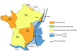
The Paris Basin is one of the major geological regions of France. It developed since the Triassic over remnant uplands of the Variscan orogeny. The sedimentary basin, no longer a single drainage basin, is a large sag in the craton, bordered by the Armorican Massif to the west, the Ardennes-Brabant axis to the north, the Massif des Vosges to the east, and the Massif Central to the south.
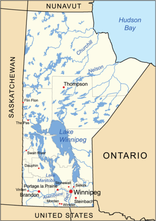
The geography of Manitoba addresses the easternmost of the three prairie Canadian provinces, located in the longitudinal centre of Canada. Manitoba borders on Saskatchewan to the west, Ontario to the east, Nunavut to the north, and the American states of North Dakota and Minnesota to the south. Although the border with Saskatchewan appears straight on large-scale maps, it actually has many right-angle corners that give the appearance of a slanted line. In elevation, Manitoba ranges from sea level on Hudson Bay to 2727 ft (831 m) on top of Baldy Mountain. The northern sixty percent of the province is on the Canadian Shield. The northernmost regions of Manitoba lie permafrost, and a section of tundra bordering Hudson Bay.

The Pembina Escarpment is a scarp that runs from South Dakota to Manitoba, and forms the western wall of the Red River Valley. The height of the escarpment above the river valley is 300–400 feet (91–122 m).
The Manitoba Escarpment, or the Western Manitoba Uplands, are a range of hills along the Saskatchewan–Manitoba border. The eastern slopes of the range are considered to be a scarp. They were created by glacial scouring and formed the western shore of prehistoric Lake Agassiz.

In geology and geomorphology, a hogback or hog's back is a long, narrow ridge or a series of hills with a narrow crest and steep slopes of nearly equal inclination on both flanks. Typically, the term is restricted to a ridge created by the differential erosion of outcropping, steeply dipping, homoclinal, and typically sedimentary strata. One side of a hogback consists of the surface of a steeply dipping rock stratum called a dip slope. The other side is an erosion face that cuts through the dipping strata that comprises the hogback. The name "hogback" comes from the Hog's Back of the North Downs in Surrey, England, which refers to the landform's resemblance in outline to the back of a hog. The term is also sometimes applied to drumlins and, in Maine, to both eskers and ridges known as "horsebacks".

Tephroseris palustris, also known by its common names swamp ragwort, northern swamp groundsel, marsh fleabane, marsh fleawort, clustered marsh ragwort and mastodon flower, a herbaceous species of the family Asteraceae. It can be seen most easily when its bright yellow umbel flowers appear from May to early July standing 3 to 4 feet along marshes, stream banks and slough areas where it likes to grow.
The following radio stations broadcast on FM frequency 93.7 MHz:
The following radio stations broadcast on FM frequency 103.5 MHz:
The following radio stations broadcast on FM frequency 89.9 MHz:
The following radio stations broadcast on FM frequency 93.3 MHz:
The following radio stations broadcast on FM frequency 105.1 MHz:

The Erie Plain is a lacustrine plain that borders Lake Erie in North America. From Buffalo, New York, to Cleveland, Ohio, it is quite narrow, but broadens considerably from Cleveland around Lake Erie to Southern Ontario, where it forms most of the Ontario peninsula. The Erie Plain was used in the United States as a natural gateway to the North American interior, and in both the United States and Canada the plain is heavily populated and provides very fertile agricultural land.