Lewiston Hill

Last updated
Lewiston Hill
Lewiston ID and Clarkston WA city and rivers view 2006.jpg
Looking south from the top in 2006
Elevation 2,756 ft (840 m)
Length5.3 miles (8.5 km)
Traversed byUS 95.svg US 95
Max gradient7 %
Location Nez Perce County,
Idaho, U.S.
Coordinates 46°27′37″N117°00′58″W / 46.4602°N 117.0162°W / 46.4602; -117.0162
Usa edcp relief location map.png
Red pog.svg
Lewiston Hill
Location in the United States
USA Idaho relief location map.svg
Red pog.svg
Lewiston Hill
Location in Idaho

Lewiston Hill (also known as the "Clearwater Escarpment" [1] ) is a large sloping escarpment in the northwest United States, located immediately north of the confluence of the Clearwater and Snake rivers in north central Idaho.

Contents

Residents of the nearby cities of Lewiston, Idaho, and Clarkston, Washington, typically refer to "Lewiston Hill" as the mostly unfarmed land north of the city limits of the respective cities, but still remaining visible from the cities. At the top of the escarpment is a notable agricultural region known as the Palouse.

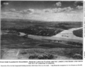
The border between Lewiston Hill and the Palouse is at an approximate elevation of 2,756 feet (840 m) above sea level, as measured at a rest area at the junction of U.S. Routes 95 and 195. At the foot of the hill is the eastern end of Lower Granite Lake, at the confluence of the Clearwater and Snake rivers; its typical surface elevation is 741 feet (226 m), [2] yielding a vertical drop of 2,015 feet (614 m) to the water.

Just below the summit of the escarpment and north of both city centers, there are corresponding initials for Lewiston (L) and Clarkston (C), painted white.

Highways

Lewiston Hill Highway circa 1920 Section of the Lewiston Hill Highway known as The Loop near Lewiston, Idaho, circa 1920 (AL+CA 1531).jpg
Lewiston Hill Highway circa 1920
Sign at top of Lewiston Hill. LewistonHillSignSept2010.jpg
Sign at top of Lewiston Hill.

Old Spiral Highway

The Old Spiral Highway, near Lewiston, Idaho, circa 1920. Lewiston Hill Highway grade, near Lewiston, Idaho, circa 1920 (AL+CA 1526).jpg
The Old Spiral Highway, near Lewiston, Idaho, circa 1920.

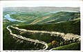
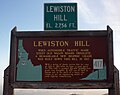
Branching off of State Highway 128 (just east of the Washington-Idaho transition from Washington State Route 128), the "Old Spiral Highway" and former ten-mile (16 km) segment of U.S. Route 95 climbs two thousand vertical feet (610 m) above the riverbank north of the confluence of the Snake and Clearwater rivers. The summit is at 2,756 ft (840 m), following a very twisty road (64 curves) that was opened in 1917. It was the primary route north for sixty years, and received an award as one of the best-engineered stretches of mountain highway at the time. Studies for a replacement route were begun in the mid-1960s; [3] it was decommissioned in 1977, when the current alignment of U.S. Route 95 was opened.

The 1950s rock and roll hit by singer-songwriter Charlie Ryan titled "Hot Rod Lincoln" tells of an actual race on that hill. The lyrics of the song were changed variously to say San Pedro or The Grapevine in later versions, but the Ryan claimed at later performances that he was inspired by Lewiston Hill. [4]

In 1990, the fifth stage of the Ore-Ida Women's Challenge cycling race went through Lewiston and ended with a climb up the Old Spiral Highway. [5]

The north end of the Old Spiral Highway joins with U.S. Routes 95 and 195 on the Washington-Idaho border.

Lewiston Hill
the Old Spiral Highway

U.S. Route 95 up Lewiston Hill

The newer multi-lane grade of U.S. Route 95 ascending the slope to the north of Lewiston is often simply referred to as "Lewiston Hill" by local residents. [6] Constructed from 1975 to 1977, it yields a straighter and steeper sweeping "Z" descent to the east, then back to the southwest, and is approximately seven miles (11 km) in length. [7] [8]

Scenery

1917 View from Clearwater Escarpment, showing Lewiston Plateau and the lower-lying bench upon which the City of Lewiston is located ClearwaterEscarpment-Lewiston-USDA-1917.png
1917 View from Clearwater Escarpment, showing Lewiston Plateau and the lower-lying bench upon which the City of Lewiston is located

Both grades provide excellent views of the Lewiston-Clarkston area and beyond.

Panorama shot of Lewiston Hill from the top of the hill. Lewiston, Clarkston, Snake River, Clearwater River pano 01.jpg
Panorama shot of Lewiston Hill from the top of the hill.

Related Research Articles

<span class="mw-page-title-main">Lewiston, Idaho</span> City in Idaho, United States

Lewiston is a city and the county seat of Nez Perce County, Idaho, United States, in the state's north central region. It is the third-largest city in the northern Idaho region, behind Post Falls and Coeur d'Alene, and the twelfth-largest in the state. Lewiston is the principal city of the Lewiston, ID-WA Metropolitan Statistical Area, which includes all of Nez Perce County and Asotin County, Washington. As of the 2020 census, the population of Lewiston was 34,203, up from 31,894 in 2010.

<span class="mw-page-title-main">Moscow, Idaho</span> City in northern Idaho, United States

Moscow is a city and the county seat of Latah County, Idaho. Located in the North Central region of the state along the border with Washington, it had a population of 25,435 at the 2020 census. Moscow is the home of the University of Idaho, the state's land-grant institution and primary research university.

<span class="mw-page-title-main">U.S. Route 95</span> Highway in the United States

U.S. Route 95 (US 95) is a major north–south United States Highway in the western United States. It travels through the states of Arizona, California, Nevada, Oregon, and Idaho, staying inland from the Pacific Coast. US 95 begins in San Luis, Arizona, at the Mexican border, where Calle 1—a short spur—leads to Highway 2 in San Luis Río Colorado, Sonora. Its northern terminus is at the Canadian border in Eastport, Idaho, where the roadway continues north as British Columbia Highway 95.

<span class="mw-page-title-main">North Central Idaho</span> Region of Idaho, USA

North Central Idaho is an area which spans the central part of the state of Idaho and borders Oregon, Montana, and Washington. It is the southern half of the state's Panhandle region and is rich in agriculture and natural resources. Lewis and Clark traveled through this area on their journey to the Pacific Ocean in September 1805, crossing Lolo Pass and continuing westward in canoes on the Clearwater River. They returned the following spring on their way eastward.

<span class="mw-page-title-main">U.S. Route 195</span> U.S. Highway in Washington (state) and Idaho in the United States

U.S. Route 195 (US 195) is a north–south United States Highway, of which all but 0.65 miles of its 94.02 miles are within the state of Washington. The highway starts in rural Idaho north of the city of Lewiston as a state highway in an interchange with US 95. As the road crosses into Washington it becomes a state highway that connects communities in the Palouse region of Eastern Washington. US 195 travels north, serving the cities of Pullman, Colfax and Rosalia in Whitman County before continuing into Spokane County to its terminus in the city of Spokane at an interchange with Interstate 90 (I-90).

<span class="mw-page-title-main">Lewiston–Nez Perce County Airport</span> Airport

Lewiston–Nez Perce County Airport is a public airport in the northwest United States, in north central Idaho. Owned by the city of Lewiston and Nez Perce County, it is in an elevated area of the city two miles (3 km) south of downtown, approximately 700 vertical feet (210 m) above the Snake and Clearwater rivers.

<span class="mw-page-title-main">Lower Granite Dam</span> Dam in Garfield and Whitman counties, Washington

Lower Granite Lock and Dam is a concrete gravity run-of-the-river dam in southeastern Washington in the United States. On the lower Snake River, it bridges Whitman and Garfield counties. Opened 49 years ago in 1975, the dam is located 22 miles (35 km) south of Colfax and 35 miles (56 km) north of Pomeroy.

<span class="mw-page-title-main">Washington State Route 128</span> State highway in Washington, United States

State Route 128 (SR 128) is a Washington state highway located in Asotin and Whitman counties, west of the Idaho state line. The 2.30-mile (3.70 km) long route runs north from U.S. Route 12 (US 12) in Clarkston to cross the Snake River and turn east after intersecting SR 193 to terminate at State Highway 128 (SH 128) on the Idaho state line. The highway was originally created in 1964 on a Pomeroy–Clarkston route, replacing Secondary State Highway 3K (SSH 3K), which had been established in 1937; in 1991, the route was changed to its present form.

<span class="mw-page-title-main">Washington State Route 129</span> Highway in Washington

State Route 129 (SR 129) is a state highway in Asotin County, Washington, United States. It travels north–south at the southeastern corner of the state, connecting with Oregon Route 3 (OR 3) at the Oregon state line south of Anatone. The 43-mile (69 km) highway then follows the Snake River, which marks the Idaho state border, north to Clarkston and terminates at U.S. Route 12 (US 12). SR 129 also has a short spur route that connects to a separate intersection with US 12 in Clarkston.

<span class="mw-page-title-main">Lewiston–Clarkston metropolitan area</span> Metropolitan statistical area in the United States

The Lewiston–Clarkston metropolitan area—colloquially referred to as the Lewiston–Clarkston Valley or Lewis–Clark Valley, and officially known as the Lewiston, ID–WA Metropolitan Statistical Area—is a metropolitan area comprising Nez Perce County, Idaho and Asotin County, Washington. The metro is anchored by the cities of Lewiston, Idaho and Clarkston, Washington—named after Meriwether Lewis and William Clark, respectively. As of the 2010 census, the MSA had a population of 60,888, making it the 4th smallest metropolitan area in the United States.

<span class="mw-page-title-main">Washington State Route 193</span> State highway in Washington, United States

State Route 193 (SR 193) is a 2.58-mile (4.15 km) long state highway that serves the Port of Wilma in Whitman County, located in the U.S. state of Washington. The highway parallels the Snake River from an intersection with SR 128 north of Clarkston to the Port of Wilma. The current road is a short segment of the former route that extended from U.S. Route 12 (US 12) in Clarkston to US 195 west of Colton that was added to the highway system in 1969 as Secondary State Highway 3G (SSH 3G) in 1969 and removed in 1992.

<span class="mw-page-title-main">Idaho State Highway 6</span> State highway in Idaho, United States

State Highway 6 (SH-6) is a state highway in northern Idaho running from the Washington state line near Potlatch to Santa. It is 40.645 miles (65.41 km) in length and generally runs southwest to northeast

<span class="mw-page-title-main">U.S. Route 12 in Idaho</span> Section of U.S. Highway in Idaho, United States

U.S. Route 12 (US-12) is a United States Numbered Highway in North Central Idaho. It extends 174.410 miles (280.686 km) from the Washington state line in Lewiston east to the Montana state line at Lolo Pass, generally along the route of the Lewis and Clark Expedition, and is known as the Northwest Passage Scenic Byway. It was previously known as the Lewis and Clark Highway.

<span class="mw-page-title-main">U.S. Route 95 in Idaho</span> Section of U.S. Highway in Idaho, United States

In the U.S. state of Idaho, U.S. Route 95 (US-95) is a north–south highway near the western border of the state, stretching from Oregon to British Columbia for over 538 miles (866 km); it was earlier known in the state as the North and South Highway.

<span class="mw-page-title-main">Clearwater River (Idaho)</span> River in Idaho, United States

The Clearwater River is in the northwestern United States, in north central Idaho. Its length is 74.8 miles (120.4 km), it flows westward from the Bitterroot Mountains along the Idaho-Montana border, and joins the Snake River at Lewiston. In October 1805, the Lewis and Clark Expedition descended the Clearwater River in dugout canoes, putting in at "Canoe Camp," five miles (8 km) downstream from Orofino; they reached the Columbia Bar and the Pacific Ocean about six weeks later.

<span class="mw-page-title-main">Idaho State Highway 128</span> State highway in Idaho, United States

State Highway 128 (SH-128) is a 2.2-mile-long (3.5 km) state highway in the U.S. state of Idaho, serving the city of Lewiston in Nez Perce County. The highway travels east along the Clearwater River within Lewiston from Washington State Route 128 (SR 128) to U.S. Route 12 (US 12). It was created in 1989 after improvements were made to an existing county road.

<span class="mw-page-title-main">Southway Bridge</span>

The Southway Bridge is a highway bridge spanning the Snake River between Clarkston, Washington, and Lewiston, Idaho. It connects Fleshman Way in Clarkston with Bryden Canyon Road in Lewiston, and provides residents of the Lewiston Orchards with access to State Route 129, as well as providing Clarkston residents with access to the Lewiston–Nez Perce County Airport. The bridge was opened to traffic on August 3, 1982, at a cost of $21 million, after several delays due to repairs. The Bryden County Road project linking the bridge to the Lewiston Orchards was completed in 1999.

<span class="mw-page-title-main">Interstate Highway Bridge</span> U.S. highway bridge between Clarkston, Washington and Lewiston, Idaho

The Interstate Highway Bridge crosses the Snake River, between Clarkston, Washington and Lewiston, Idaho. The bridge carries U.S. Route 12 (US 12) across the state line between Washington and Idaho, and is maintained by the Washington State Department of Transportation. It was built in 1939 and is 1,424 feet (434 m) long. It is nicknamed the "Blue Bridge" locally.

<span class="mw-page-title-main">Lower Granite Lake</span>

Lower Granite Lake is a reservoir created by Lower Granite Dam. The dam is a concrete gravity run-of-the-river dam in the northwest United States. On the lower Snake River in southeastern Washington, it bridges Whitman and Garfield counties. Opened 49 years ago in 1975, the dam is located 22 miles (35 km) south of Colfax and 35 miles (56 km) north of Pomeroy.

U.S. Bicycle Route 81 (USBR 81) is a United States Bicycle Route in the state of Washington. It is planned to travel north–south along the eastern edge of the state from Asotin to the Canadian border near Metaline Falls. The section from Asotin to Clarkston and Tekoa, spanning 103.5 miles (166.6 km), was designated in 2021. USBR 81 also has a child route, USBR 281, that was designated in 2021 and follows U.S. Route 195.

References

  1. Parsons, Donna L. (1968-09-30). Idaho, An Outdoor Classroom. Caldwell School District 132, ID.
  2. "File:LewistonHillSignSept2010.jpg", Wikipedia, 2011-12-30, retrieved 2020-12-12
  3. Harrell, Sylvia (December 26, 1965). "Study started to eliminate Spiral". Lewiston Morning Tribune. p. 26.
  4. Johnson, David (June 27, 2003). "That hot rod Lincoln". Lewiston Morning Tribune . Retrieved 2020-12-11.
  5. Sahlberg, Bert (June 27, 1990). "Thompson likes view from above". Lewiston Morning Tribune. p. 1D.
  6. Stovall, Scott (2014-12-04). "Lewiston Hill resurfacing project begins this spring". KLEW-TV . Retrieved 2020-12-12.
  7. "First dirt moved for new highway up Lewiston Hill". Lewiston Morning Tribune. August 1, 1975. p. 7A.
  8. Harrell, Sylvia (October 27, 1977). "What a way to go!". Lewiston Morning Tribune. p. 1D. Archived from the original on November 23, 2015. Retrieved November 22, 2015.