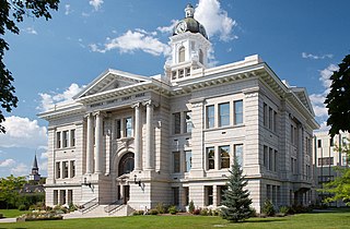
Missoula County is a county located in the State of Montana. As of the 2020 census, the population was 117,922, making it Montana's third most populous county. Its county seat and most populous city is Missoula. The county was founded in 1860.

The Continental Divide of the Americas is the principal, and largely mountainous, hydrological divide of the Americas. The Continental Divide extends from the Bering Strait to the Strait of Magellan, and separates the watersheds that drain into the Pacific Ocean from those river systems that drain into the Atlantic and Arctic Ocean, including those that drain into the Gulf of Mexico, the Caribbean Sea, and Hudson Bay.

The East China Sea is a marginal sea of the Western Pacific Ocean, located directly offshore from East China. China names the body of water along its eastern coast as "East Sea" due to direction, the name of "East China Sea" is otherwise designated as a formal name by International Hydrographic Organization (IHO) and used internationally.

In geography, a pole of inaccessibility is the farthest location in a given landmass, sea, or other topographical feature, starting from a given boundary, relative to a given criterion. A geographical criterion of inaccessibility marks a location that is the most challenging to reach according to that criterion. Often it refers to the most distant point from the coastline, implying the farthest point into a landmass from the shore, or the farthest point into a body of water from the shore. In these cases, a pole of inaccessibility is the center of a maximally large circle that can be drawn within an area of interest only touching but not crossing a coastline. Where a coast is imprecisely defined, the pole will be similarly imprecise.

The Eastern Continental Divide, Eastern Divide or Appalachian Divide is a hydrological divide in eastern North America that separates the easterly Atlantic Seaboard watershed from the westerly Gulf of Mexico watershed. The divide nearly spans the United States from south of Lake Ontario through the Florida peninsula, and consists of raised terrain including the Appalachian Mountains to the north, the southern Piedmont Plateau and lowland ridges in the Atlantic Coastal Plain to the south. Water including rainfall and snowfall, lakes, streams and rivers on the eastern/southern side of the divide drains to the Atlantic Ocean; water on the western/northern side of the divide drains to the Gulf of Mexico. The ECD is one of six continental hydrological divides of North America which define several drainage basins, each of which drains to a particular body of water.
This article lists extreme locations on Earth that hold geographical records or are otherwise known for their geophysical or meteorological superlatives. All of these locations are Earth-wide extremes; extremes of individual continents or countries are not listed.

Torreys Peak is a mountain in the Front Range region of the Rocky Mountains in Colorado. It is one of 53 fourteeners in Colorado. Its nearest major city is Denver. Torreys Peak is located along the Continental Divide, as well as the division between Clear Creek County and Summit County. In the Arapaho language Torrey's Peak and the adjacent Gray's Peak are named, Heeniiyoowuu or "Ant Hills".

The Allegheny Front is the major southeast- or east-facing escarpment in the Allegheny Mountains in southern Pennsylvania, western Maryland, eastern West Virginia, and western Virginia. The Allegheny Front forms the boundary between the Ridge-and-Valley Appalachians to its east and the Appalachian Plateau to its west. The Front is closely associated with the Appalachian Mountains' Eastern Continental Divide, which in this area divides the waters of the Ohio/Mississippi river system, flowing to the Gulf of Mexico, from rivers flowing into Chesapeake Bay and from there into the Atlantic Ocean.
In hydrology, an oceanic basin (or ocean basin) is anywhere on Earth that is covered by seawater. Geologically, most of the ocean basins are large geologic basins that are below sea level.

The Great Divide Basin or Great Divide Closed Basin is an area of land in the Red Desert of Wyoming where none of the water falling as rain to the ground drains into any ocean, directly or indirectly. It is thus an endorheic basin, one of several in North America that adjoin the Continental Divide. To the south and west of the basin is the Green River watershed, draining to the Gulf of California/Pacific Ocean; to the north and east is the North Platte watershed, draining to the Gulf of Mexico. The basin is very roughly rectangular in shape; the northwest corner is at Oregon Buttes near South Pass, about 40 miles (64 km) southwest of Lander, and the southeast corner is in the Sierra Madre Range near Bridger Pass, about 20 miles (32 km) southwest of Rawlins.

The Beaverhead–Deerlodge National Forest is the largest of the National Forests in Montana, United States. Covering 3.36 million acres (13,600 km2), the forest is broken into nine separate sections and stretches across eight counties in the southwestern area of the state. President Theodore Roosevelt named the two forests in 1908 and they were merged in 1996. Forest headquarters are located in Dillon, Montana. In Roosevelt's original legislation, the Deerlodge National Forest was called the Big Hole Forest Reserve. He created this reserve because the Anaconda Copper Mining Company, based in Butte, Montana, had begun to clearcut the upper Big Hole River watershed. The subsequent erosion, exacerbated by smoke pollution from the Anaconda smelter, was devastating the region. Ranchers and conservationists alike complained to Roosevelt, who made several trips to the area. (Munday 2001)

Logan Pass is located along the Continental Divide in Glacier National Park, in the U.S. state of Montana. It is the highest point on the Going-to-the-Sun Road. The pass is named after Major William R. Logan, the first superintendent of the park.

The Weminuche Wilderness is a wilderness area in southwest Colorado managed by the United States Forest Service as part of the San Juan National Forest on the west side of the Continental Divide and the Rio Grande National Forest on the east side of the divide. The Weminuche Wilderness was designated by Congress in 1975, and expanded by the Colorado Wilderness Acts of 1980 and 1993. It is located 4 miles (6.4 km) southeast of the town of Silverton, 17 miles (27 km) northeast of Durango, and 8 miles (13 km) west of South Fork. At 499,771 acres (2,022.50 km2), it is the largest wilderness area in the state of Colorado. Elevation in the wilderness ranges from 7,700 feet (2,300 m) along the Animas River to 14,093 feet (4,296 m) at the summit of Windom Peak.

The Highline Trail is a scenic hiking trail in Glacier National Park, Montana, United States. The trail stretches 7.6 miles (12.2 km) from Logan Pass to Granite Park Chalet, and continues another 11.9 miles (19.2 km) from there to Fifty Mountain Campground. The trail follows the Garden Wall ridge and the continental divide for most of its length. The trail offers scenic views of glaciated U-shaped valleys. A 1.2-mile (1.9 km) round trip side trail takes hikers up the side of the Garden Wall to an overlook to Grinnell Glacier.

The Great Escarpment is a major topographical feature in Africa that consists of steep slopes from the high central Southern African plateau downward in the direction of the oceans that surround southern Africa on three sides. While it lies predominantly within the borders of South Africa, in the east the escarpment extends northward to form the border between Mozambique and Zimbabwe, continuing on beyond the Zambezi river valley to form the Muchinga Escarpment in eastern Zambia. In the west, it extends northward into Namibia and Angola. It is the combination of this escarpment and the aridity of Southern Africa that leads to the lack of navigable rivers in South Africa.
The South Warner Wilderness is a federally designated wilderness area 12 miles (19 km) east of Alturas, California, United States. It encompasses more than 70,000 acres (283 km2) of the Warner Mountains. It is within the Modoc National Forest and managed by the US Forest Service. Elevations range from 5,000 feet (1,500 m) to 9,895 feet at Eagle Peak.

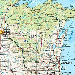
Wisconsin, a state in the Midwestern United States, has a vast and diverse geography famous for its landforms created by glaciers during the Wisconsin glaciation 17,000 years ago. The state can be generally divided into five geographic regions—Lake Superior Lowland, Northern Highland, Central Plain, Eastern Ridges & Lowlands, and Western Upland. The southwestern part of the state, which was not covered by glaciers during the most recent ice age, is known as the Driftless Area. The Wisconsin glaciation formed the Wisconsin Dells, Devil's Lake, and the Baraboo Range. A number of areas are protected in the state, including Devil's Lake State Park, the Apostle Islands National Lakeshore, and the Chequamegon–Nicolet National Forest.

Grays Peak National Recreation Trail or Grays Peak Trail lies along the Continental Divide of the Americas, part of the Rocky Mountains in the U.S. state of Colorado. It is located in the White River National Forest, Summit County. Grays Peak Trail is south of Interstate 70, east of Keystone Resort and near Montezuma. Grays Peak is adjacent to Torreys Peak.
Lewis and Clark Pass is a mountain pass on the continental divide in Montana, United States, at an elevation of 6,424 feet (1,958 m) above sea level. The pass lies at the head of the drainages of the west-flowing Blackfoot River and the east-flowing Dearborn River, in the Helena National Forest in Lewis and Clark County. The Continental Divide Trail traverses north and south through the pass.
The San Pedro Parks Wilderness is located in southern Rio Arriba County in northern New Mexico and part of the Santa Fe National Forest. It is 41,132 acres (16,646 ha) in size. Elevations range from 8,300 feet (2,500 m) in the southwestern corner to 10,592 feet (3,228 m) at San Pedro Peaks near the center of the Wilderness. The Wilderness's average elevation is over 10,000 ft. Conifer forests, interspaced with grassy meadows, called "parks", characterize the wilderness. San Pedro Parks Wilderness is primarily visited for hiking, camping, hunting, and fishing. The Continental Divide Trail passes through the Wilderness.


