Related Research Articles

Allamakee County is the northeasternmost county in the U.S. state of Iowa. As of the 2020 census, the population was 14,061. Its county seat is Waukon.

The Niagara Escarpment is a long escarpment, or cuesta, in Canada and the United States that starts from the south shore of Lake Ontario westward, circumscribes the top of the Great Lakes Basin running from New York through Ontario, Michigan, and Wisconsin. The escarpment is the cliff over which the Niagara River plunges at Niagara Falls, for which it is named.

The Pennyroyal Plateau or Pennyroyal Region, often spelled Pennyrile, is a large physiographic region of Kentucky that features rolling hills, caves, and karst topography in general. It is named for Hedeoma pulegioides, a wild mint that grows in the area. It is also called the "Mississippian Plateau," for the Mississippian geologic age in which it was formed.

Halton Hills is a town in the Regional Municipality of Halton, located in the northwestern end of the Greater Toronto Area, Ontario, Canada with a population of 62,951 (2021).
The Highland Rim is a geographic term for the area in Tennessee, North Alabama, and Kentucky which surrounds the Central Basin. Geologically, the Central Basin is a dome. The Highland Rim is a cuesta surrounding the basin, and the border where the difference in elevation is sharply pronounced is an escarpment.

The Onondaga Limestone is a group of hard limestones and dolomites of Devonian age that forms geographic features in some areas in which it outcrops; in others, especially its Southern Ontario portion, the formation can be less prominent as a local surface feature.

The Allegheny Front is the major southeast- or east-facing escarpment in the Allegheny Mountains in southern Pennsylvania, western Maryland, eastern West Virginia, and western Virginia. The Allegheny Front forms the boundary between the Ridge-and-Valley Appalachians to its east and the Appalachian Plateau to its west. The Front is closely associated with the Appalachian Mountains' Eastern Continental Divide, which in this area divides the waters of the Ohio/Mississippi river system, flowing to the Gulf of Mexico, from rivers flowing into Chesapeake Bay and from there into the Atlantic Ocean.

The Gulf Coastal Plain extends around the Gulf of Mexico in the Southern United States and eastern Mexico.

The Driftless Area, also known as Bluff Country and the Paleozoic Plateau, is a topographical and cultural region in the Midwestern United States that comprises southwestern Wisconsin, southeastern Minnesota, northeastern Iowa, and the extreme northwestern corner of Illinois. The Driftless Area is a USDA Level III Ecoregion: Ecoregion 52. The Driftless Area takes up a large portion of the Upper Midwest forest–savanna transition. The eastern section of the Driftless Area in Minnesota is called the Blufflands, due to the steep bluffs and cliffs around the river valleys. The western half is known as the Rochester Plateau, which is flatter than the Blufflands. The Coulee Region is the southwestern part of the Driftless Area in Wisconsin. It is named for its numerous ravines.

The Eastern Ridges and Lowlands is a geographical region in the eastern part of the U.S. state of Wisconsin, between Green Bay in the north, and the border with Illinois in the south. Lake Michigan lies to the east of the region.
The Trafalgar Moraine is a geological landform straddling Oakville and Milton in Ontario, Canada. A small portion of the moraine extends into Burlington at Milton's southern border. It is a subtler topological feature than the better-known Oak Ridges Moraine, primarily because it was formed as an end moraine at the terminus of a glacial ice sheet, instead of between two retreating ice lobes. The ice sheet pushed material to form the ridge, which is composed of Halton Till sediment, rich in silt and clay. By contrast, the Oak Ridges Moraine is primarily sand and gravel. The ridge was probably formed during a pause in the retreat of the ice sheet. The moraine covers an area of 892.5 hectares of primarily private land, though a small portion is public.

The Dissected Till Plains are physiographic sections of the Central Lowlands province, which in turn is part of the Interior Plains physiographic division of the United States, located in southern and western Iowa, northeastern Kansas, the southwestern corner of Minnesota, northern Missouri, eastern Nebraska, and southeastern South Dakota.

The Garden Peninsula is a peninsula of 22 miles (35 km) in length that extends southwestward into Lake Michigan from the mainland of Michigan's Upper Peninsula. The peninsula is bordered by Lake Michigan on the east, and by Big Bay de Noc on the west. The base of the peninsula is served by U.S. Highway 2, and the peninsula's west shore is reached by M-183. The largest settlement on the peninsula is the village of Garden.

The geology of Minnesota comprises the rock, minerals, and soils of the U.S. state of Minnesota, including their formation, development, distribution, and condition.
The Humberhead Levels is a national character area covering a large expanse of flat, low-lying land towards the western end of the Humber estuary in northern England. The levels occupy the former Glacial Lake Humber, an area bounded to the east by the Yorkshire Wolds and the northern Lincolnshire Edge, a limestone escarpment, and to the west by the southern part of the Yorkshire magnesian limestone ridge. In the north the levels merge into the slightly more undulating Vale of York close to the Escrick glacial moraine, and to the south merge into the Trent Vale.

Wisconsin, a state in the Midwestern United States, has a vast and diverse geography famous for its landforms created by glaciers during the Wisconsin glaciation 17,000 years ago. The state can be generally divided into five geographic regions—Lake Superior Lowland, Northern Highland, Central Plain, Eastern Ridges & Lowlands, and Western Upland. The southwestern part of the state, which was not covered by glaciers during the most recent ice age, is known as the Driftless Area. The Wisconsin glaciation formed the Wisconsin Dells, Devil's Lake, and the Baraboo Range. A number of areas are protected in the state, including Devil's Lake State Park, the Apostle Islands National Lakeshore, and the Chequamegon–Nicolet National Forest.
The Black River Escarpment is a geological feature in Southeastern Ontario. The escarpment marks the boundary of the older Canadian Shield bedrock and more recent Ordovician limestone. The escarpment runs from Penetanguishene on Georgian Bay to Kingston on Lake Ontario. The cliffs that mark the escarpment, when present, generally average between 5 metres (16 ft) and 15 metres (49 ft) high.
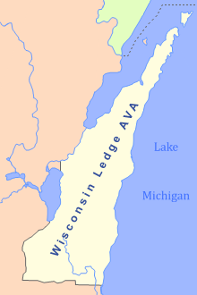
The Wisconsin Ledge AVA is an American Viticultural Area in northeast Wisconsin along the Niagara Escarpment in Door, Kewaunee, Manitowoc, Sheboygan, Ozaukee, Washington, Dodge, Fond du Lac, Calumet, Outagamie, and Brown counties. Certified by the United States Department of the Treasury's Alcohol and Tobacco Tax and Trade Bureau on March 22, 2012, it covers an area of 3,800 sq mi (9,800 km2) and is the second AVA designation wholly in Wisconsin, following the Lake Wisconsin AVA established in 1994. The state's third is the gargantuan Upper Mississippi River Valley AVA which also covers land in Minnesota, Iowa and Illinois. After 7 long years, and 4000 hours, Steven J. DeBaker of Trout Springs Winery was granted his petition to the TTB for establishment of the Wisconsin Ledge AVA. It became the 203rd AVA in the US, including just under 2.5 million acres making it the 12th largest AVA in the US. Today, there are 24 bonded wineries that lie within the AVA with over 400 acres of vines planted.
The Magnesian escarpment is the most westerly of three prominent escarpments that run north-south in Wisconsin. All three escarpments are formed by the edges of layers of sedimentary rocks. The easternmost and most prominent escarpment is the Niagara Escarpment formed where younger and harder layers of dolomite overlay softer sedimentary rocks. The Black River Escarpment is capped by another layer of relatively harder rocks, overlay older softer rocks. The rocks of the Magnesian layer overlay rocks of the Cambrian Period, the oldest sedimentary rocks that contain fossils.
The geology of Wisconsin includes Precambrian crystalline basement rock over three billion years old. A widespread marine environment during the Paleozoic flooded the region, depositing sedimentary rocks which cover most of the center and south of the state.
References
- ↑ Lawrence Martin (1965). The physical geography of Wisconsin . University of Wisconsin Press. p. 247. ISBN 978-0-299-03475-7 . Retrieved 2010-09-14.
- ↑ "The Eastern Ridges and Lowlands of Wisconsin". Wisconsin Online. Archived from the original on 2010-06-17. Retrieved 2010-09-14.
| | This article about a location in the state of Wisconsin is a stub. You can help Wikipedia by expanding it. |