
Olympus Mons is a large shield volcano on Mars. The volcano has a height of over 21.9 km as measured by the Mars Orbiter Laser Altimeter (MOLA). Olympus Mons is about two and a half times Mount Everest's height above sea level. It is one of the largest volcanoes, the tallest planetary mountain, and approximately tied with Rheasilvia as the tallest mountain currently discovered in the Solar System. It is associated with the Tharsis Montes, a large volcanic region on Mars. Its last eruption was 25 million years ago.

Tharsis is a vast volcanic plateau centered near the equator in the western hemisphere of Mars. The region is home to the largest volcanoes in the Solar System, including the three enormous shield volcanoes Arsia Mons, Pavonis Mons, and Ascraeus Mons, which are collectively known as the Tharsis Montes. The tallest volcano on the planet, Olympus Mons, is often associated with the Tharsis region but is actually located off the western edge of the plateau. The name Tharsis is the Greco-Latin transliteration of the biblical Tarshish, the land at the western extremity of the known world.

Areography, also known as the geography of Mars, is a subfield of planetary science that entails the delineation and characterization of regions on Mars. Areography is mainly focused on what is called physical geography on Earth; that is the distribution of physical features across Mars and their cartographic representations. In April 2023, The New York Times reported an updated global map of Mars based on images from the Hope spacecraft. A related, but much more detailed, global Mars map was released by NASA on 16 April 2023.

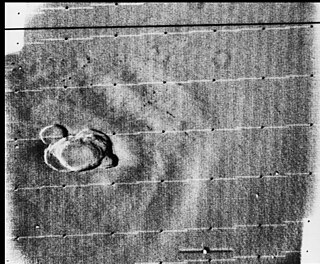
Pavonis Mons is a large shield volcano located in the Tharsis region of the planet Mars. It is the middle member of a chain of three volcanic mountains that straddle the Martian equator between longitudes 235°E and 259°E. The volcano was discovered by the Mariner 9 spacecraft in 1971, and was originally called Middle Spot. Its name formally became Pavonis Mons in 1973. The equatorial location of its peak and its height make it the ideal terminus for a space elevator, and it has often been proposed as a space elevator location, especially in science fiction. It is also an ideal location for a Sky Ramp.

Arsia Mons is the southernmost of three volcanoes on the Tharsis bulge near the equator of the planet Mars. To its north is Pavonis Mons, and north of that is Ascraeus Mons. The tallest volcano in the Solar System, Olympus Mons, is to its northwest. Its name comes from a corresponding albedo feature on a map by Giovanni Schiaparelli, which he named in turn after the legendary Roman forest of Arsia Silva. Historically, it was known as Nodus Gordii before being renamed.

The Tharsis Montes are three large shield volcanoes in the Tharsis region of the planet Mars. From north to south, the volcanoes are Ascraeus Mons, Pavonis Mons and Arsia Mons. Mons is the Latin word for mountain; it is a descriptor term used in astrogeology for mountainous features in the Solar System.

Planum Boreum is the northern polar plain on Mars. It extends northward from roughly 80°N and is centered at 88.0°N 15.0°E. Surrounding the high polar plain is a flat and featureless lowland plain called Vastitas Borealis which extends for approximately 1500 kilometres southwards, dominating the northern hemisphere.
Rupes is the Latin word for 'cliff'. It is used in planetary geology to refer to escarpments on other worlds. As of January 2013, the IAU has named 62 such features in the Solar System, on Mercury (17), Venus (7), the Moon (8), Mars (23), the asteroids Vesta (2) and Lutetia (2), and Uranus's satellites Miranda (2) and Titania (1).
Olympus or Olympos may refer to:

Mount Olympus is the highest mountain in Greece. It is part of the Olympus massif near the Thermaic Gulf of the Aegean Sea, located in the Olympus Range on the border between Thessaly and Macedonia, between the regional units of Larissa and Pieria, about 80 km (50 mi) southwest from Thessaloniki. Mount Olympus has 52 peaks and deep gorges. The highest peak, Mytikas, meaning "nose", rises to 2,917.727 metres (9,572.60 ft). It is one of the highest peaks in Europe in terms of topographic prominence.
Volcanic activity, or volcanism, has played a significant role in the geologic evolution of Mars. Scientists have known since the Mariner 9 mission in 1972 that volcanic features cover large portions of the Martian surface. These features include extensive lava flows, vast lava plains, and the largest known volcanoes in the Solar System. Martian volcanic features range in age from Noachian to late Amazonian, indicating that the planet has been volcanically active throughout its history, and some speculate it probably still is so today. Both Earth and Mars are large, differentiated planets built from similar chondritic materials. Many of the same magmatic processes that occur on Earth also occurred on Mars, and both planets are similar enough compositionally that the same names can be applied to their igneous rocks and minerals.

The Tharsis quadrangle is one of a series of 30 quadrangle maps of Mars used by the United States Geological Survey (USGS) Astrogeology Research Program. The Tharsis quadrangle is also referred to as MC-9 . The name Tharsis refers to a land mentioned in the Bible. It may be at the location of the old town of Tartessus at the mouth of Guadalquivir.

Claritas Rupes is a scarp in the Phoenicis Lacus quadrangle of Mars, located at 26° South and 105.4° West. It is 924 km long and was named after an albedo feature at 25S, 110W. The term "Rupes" is used in planetary geology to refer to an escarpments or cliff on Mars and other planets. It is the Latin word for cliff.

Euboea Montes is a mountain on Io, a moon of Jupiter. Its coordinates are at 48.89°S 338.77°W. It is about 10.5±1 km high, and was formed by tilting of a crustal block, with subsequent modification by a very large landslide.

Abalos Undae is a dune field on Mars in the periphery of Planum Boreum, the Martian North pole. It is one of the officially named northern circumpolar dune fields, along with Olympia, Hyperboreae, and Siton Undae, and also one of the densest of the region. Its northernmost boundary is located in the southwest channel that separates the Abalos Colles formation from the main polar ice cap, and from there the dune field extends southwest all the way to the lowlands of Vastitas Borealis.

Rupes Tenuis is a Martian north polar scarp. It is named after one of the classical albedo features on Mars. Its name was officially approved by IAU in 1988. It extends from latitude 74.94°N to 82.2°N and from longitude 242.12°E to 300.77°E. Its centre is located at latitude 81.6°N longitude 85.47°W. It marks the outer perimeter of Planum Boreum from longitude 242.12°E to 300.77°E, and it is formed by the eastern extension of the Olympia Cavi, a series of local troughs and depressions, which become longer and deeper as they merge to create the Rupes Tenuis scarp formation. The scarp is located to the west of Chasma Boreale, at the base of Planum Boreum, and its height varies from a few hundred metres to a maximum of approximately 1000 metres.

Siton Undae is one of the largest and densest dune fields in the vicinity of Planum Boreum, the Martian northern polar ice-cap. It is named after one of the classical albedo features on Mars. Its name was officially approved by IAU on 20 March 2007. It extends from latitude 73.79°N to 77.5°N and from longitude 291.38°E to 301.4°E. Its centre is located at latitude 75.55°N, longitude 297.28E (62.72°W), and has a diameter of 222.97 kilometres (138.55 mi).

Aspledon Undae is one of the named northern circumpolar dune fields in the vicinity of Planum Boreum, the Martian North pole. It is named after one of the classical albedo features on Mars. Its name was officially approved by the International Astronomical Union (IAU) on 20 March 2007. Its name is Greek, and derives from the name of a town in Boeotia, Ancient Greece, which, in turn, took its name from Aspledon, son of Poseidon, the ancient Greek god of the sea. The dunes of Aspledon Undae extend from latitude 71.47°N to 75.14°N and from longitude 305.83°E to 315.04°E. Its centre is located at latitude 73.06°N, longitude 309.65°E (50.35°W), and has a diameter of 215.2 km.
