The geography of Mars, also known as areography, entails the delineation and characterization of regions on Mars. Martian geography is mainly focused on what is called physical geography on Earth; that is the distribution of physical features across Mars and their cartographic representations.

Pavonis Mons is a large shield volcano located in the Tharsis region of the planet Mars. It is the middle member of a chain of three volcanic mountains that straddle the Martian equator between longitudes 235°E and 259°E. The volcano was discovered by the Mariner 9 spacecraft in 1971, and was originally called Middle Spot. Its name formally became Pavonis Mons in 1973. The equatorial location of its peak and its height make it the ideal terminus for a space elevator, and it has often been proposed as a space elevator location, especially in science fiction. It is also an ideal location for a Sky Ramp.
The classical albedo features of Mars are the light and dark features that can be seen on the planet Mars through an Earth-based telescope. Before the age of space probes, several astronomers created maps of Mars on which they gave names to the features they could see. The most popular system of nomenclature was devised by Giovanni Schiaparelli, who used names from classical antiquity. Today, the improved understanding of Mars enabled by space probes has rendered many of the classical names obsolete for the purposes of cartography; however, some of the old names are still used to describe geographical features on the planet.

The Astrogeology Science Center is the entity within the United States Geological Survey concerned with the study of planetary geology and planetary cartography. It is housed in the Shoemaker Building in Flagstaff, Arizona. The Center was established in 1963 by Eugene Merle Shoemaker to provide lunar geologic mapping and to assist in training astronauts destined for the Moon as part of the Apollo program.

Acidalia Planitia is a plain on Mars, between the Tharsis volcanic province and Arabia Terra to the north of Valles Marineris, centered at 49.8°N 339.3°E. Most of this region is found in the Mare Acidalium quadrangle, but a small part is in the Ismenius Lacus quadrangle. The plain contains the famous Cydonia region at the contact with the heavily cratered highland terrain.

The geology of Mars is the scientific study of the surface, crust, and interior of the planet Mars. It emphasizes the composition, structure, history, and physical processes that shape the planet. It is analogous to the field of terrestrial geology. In planetary science, the term geology is used in its broadest sense to mean the study of the solid parts of planets and moons. The term incorporates aspects of geophysics, geochemistry, mineralogy, geodesy, and cartography. A neologism, areology, from the Greek word Arēs (Mars), sometimes appears as a synonym for Mars's geology in the popular media and works of science fiction. The term areology is also used in the subreddit "r/Areology" and the Areological Society.

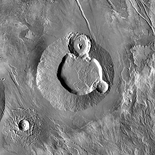
Kepler is a crater on Mars, located in the Eridania quadrangle at 46.8° S, 140.9° E. It measures approximately 228 kilometres and was named in 1973, by the International Astronomical Union, in honor of the astronomer Johannes Kepler. A section of the floor of Kepler was photographed by the HiRISE camera aboard the Mars Reconnaissance Orbiter on 25 March 2006.

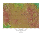
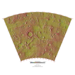
A "quadrangle" is a topographic map produced by the United States Geological Survey (USGS) covering the United States. The maps are usually named after local physiographic features. The shorthand "quad" is also used, especially with the name of the map; for example, "the Ranger Creek, Texas quad". From approximately 1947-1992, the USGS produced the 7.5 minute series, with each map covering an area one-quarter of the older 15-minute quad series, which it replaced. A 7.5 minute quadrangle map covers an area of 49 to 70 square miles. Both map series were produced via photogrammetric analysis of aerial photography using stereoplotters supplemented by field surveys. These maps employ the 1927 North American Datum (NAD27); conversion or a change in settings is necessary when using a GPS which by default employ the WGS84 geodetic datum. Beginning in 2009, the USGS made available digital versions of 7.5 minute quadrangle maps based on GIS data that use the NAD83 datum, which is typically within one meter of WGS84, or within the uncertainty of most GPS coordinate measurements. On a quadrangle map, the north and south limits are not straight lines, but are actually curved to match Earth's lines of latitude on the standard projection. The east and west limits are usually not parallel as they match Earth's lines of longitude.

The Kuiper quadrangle, located in a heavily cratered region of Mercury, includes the young, 55-km-diameter crater Kuiper, which has the highest albedo recorded on the planet, and the small crater Hun Kal, which is the principal reference point for Mercurian longitude. Impact craters and basins, their numerous secondary craters, and heavily to lightly cratered plains are the characteristic landforms of the region. At least six multiringed basins ranging from 150 km to 440 km in diameter are present. Inasmuch as multiringed basins occur widely on that part of Mercury photographed by Mariner 10, as well as on the Moon and Mars, they offer a potentially valuable basis for comparison between these planetary bodies.

Mars is the fourth planet from the Sun and the second-smallest planet in the Solar System, being larger than only Mercury. In English, Mars carries the name of the Roman god of war and is often referred to as the "Red Planet". The latter refers to the effect of the iron oxide prevalent on Mars's surface, which gives it a striking reddish appearance in the sky. Mars is a terrestrial planet with a thin atmosphere, with surface features such as impact craters, valleys, dunes, and polar ice caps.

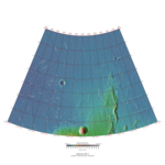
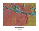
The Mare Boreum quadrangle is one of a series of 30 quadrangle maps of Mars used by the United States Geological Survey (USGS) Astrogeology Research Program. The Mare Boreum quadrangle is also referred to as MC-1. Its name derives from an older name for a feature that is now called Planum Boreum, a large plain surrounding the polar cap.

Gorgonum Chaos is a set of canyons in the Phaethontis quadrangle of Mars. It is located at 37.5° south latitude and 170.9° west longitude. Its name comes from an albedo feature at 24S, 154W. Some of the first gullies on Mars were found in Gorgonum Chaos. It is generally believed that it once contained a lake. Other nearby features are Sirenum Fossae, Maadim Vallis, Ariadnes Colles, and Atlantis Chaos. Some of the surfaces in the region are formed from the Electris deposits.
Ulysses Tholus is a Martian volcano. It is located in the Tharsis quadrangle at 2.89° north latitude and 121.55° west longitude. It is 58 km across and is named after a classical albedo feature. Ulysses Tholus is immediately east and slightly north of another volcano, Biblis Tholus. The name of the mountain itself was changed on September 19, 2007. The former terminology, Ulysses Patera, now applies only to the central caldera, whereas formerly it had applied to the whole edifice. Tholus describes a volcanic edifice somewhat smaller than would be implied by mons.

The Ulysses Fossae are a group of troughs in the Tharsis quadrangle of Mars at 10.06° north latitude and 123.07° west longitude. They were named after an albedo feature name. The area contains pitted cones called Ulysses Colles which were interpreted to be possible Martian equivalents to terrestrial cinder cones.

Sirenum Fossae is a long trough in several quadrangles including Memnonia quadrangle and Phaethontis quadrangle of Mars, centered at 35.57° south latitude and 197.26° west longitude. Sirenum Fossae is 2,735 km long and was named after a classical albedo feature name. Troughs on Mars like this one are called Fossae. Sirenum Fossae is believed to have formed by movement along a pair of faults causing a center section to drop down. This kind of feature is called a graben.

Ausonia Mensa is a mensa in the Hellas quadrangle of Mars, located at 30.3° S and 262.3° W. It is 103 km (64 mi) across and was named after an albedo feature name. The term "mensa" is used for a flat-topped prominence with cliff-like edges. Ausonia Mensa has many small channels. Some features look like alluvial fans. These channels add to the mass of evidence that water once flowed on Mars. Images of curved channels have been seen in images from Mars spacecraft dating back to the early 1970s with the Mariner 9 orbiter.

Nilosyrtis Mensae is an area of Mars in the Casius quadrangle. It is centered on the coordinates of 36.87° N and 67.9° E. Its western and eastern longitudes are 51.1° E and 74.4° E. North and south latitudes are 36.87° N and 29.61° N. Nilosyrtis Mensae is just to the east of Protonilus Mensae and both lie along the Martian dichotomy boundary. Its name was adapted by the IAU in 1973. It was named after a classical albedo feature, and it is 705 km (438 mi) across.

Hesperia Planum is a broad lava plain in the southern highlands of the planet Mars. The plain is notable for its moderate number of impact craters and abundant wrinkle ridges. It is also the location of the ancient volcano Tyrrhena Mons. The Hesperian time period on Mars is named after Hesperia Planum.
The following outline is provided as an overview of and topical guide to Mars: