
In planetary geology, an albedo feature is a large area on the surface of a planet which shows a contrast in brightness or darkness (albedo) with adjacent areas.

The classical albedo features of Mars are the light and dark features that can be seen on the planet Mars through an Earth-based telescope. Before the age of space probes, several astronomers created maps of Mars on which they gave names to the features they could see. The most popular system of nomenclature was devised by Giovanni Schiaparelli, who used names from classical antiquity. Today, the improved understanding of Mars enabled by space probes has rendered many of the classical names obsolete for the purposes of cartography; however, some of the old names are still used to describe geographical features on the planet.
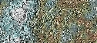
In astrogeology, chaos terrain, or chaotic terrain, is a planetary surface area where features such as ridges, cracks, and plains appear jumbled and enmeshed with one another. Chaos terrain is a notable feature of the planets Mars and Mercury, Jupiter's moon Europa, and the dwarf planet Pluto. In scientific nomenclature, "chaos" is used as a component of proper nouns.

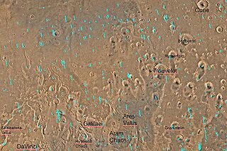
Aram Chaos, centered at 2.6°N, 21.5°W, is a heavily eroded impact crater on Mars. It lies at the eastern end of the large canyon Valles Marineris and close to Ares Vallis. Various geological processes have reduced it to a circular area of chaotic terrain. Aram Chaos takes its name from Aram, one of the classical albedo features observed by Giovanni Schiaparelli, who named it after the Biblical land of Aram. Spectroscopic observation from orbit indicates the presence of the mineral hematite, likely a signature of a once aqueous environment.

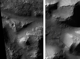
Gorgonum Chaos is a set of canyons in the Phaethontis quadrangle of Mars. It is located at 37.5° south latitude and 170.9° west longitude. Its name comes from an albedo feature at 24S, 154W. Some of the first gullies on Mars were found in Gorgonum Chaos. It is generally believed that it once contained a lake. Other nearby features are Sirenum Fossae, Maadim Vallis, Ariadnes Colles, and Atlantis Chaos. Some of the surfaces in the region are formed from the Electris deposits.
Hydaspis Chaos is a region in the Oxia Palus quadrangle of Mars, located at 3.2° north latitude and 27.1° west longitude. The region is about 355 km across. It was named after a classical albedo feature.
Shalbatana Vallis is an ancient water-worn channel on Mars, located in the Oxia Palus quadrangle at 7.8° north latitude and 42.1° west longitude. It is the westernmost of the southern Chryse outflow channels. Beginning in a zone of chaotic terrain, at 0° latitude and 46° W longitude, it ends in Chryse Planitia.

Eos Chaos is a rough, collapsed area in the Coprates quadrangle on Mars at 16.8° south latitude and 46.9° west longitude. It is about 490 km long and was named after the Greek name of Aurora, an albedo feature.
Aureum Chaos is a rough, collapsed region in the Margaritifer Sinus quadrangle (MC-19) portion of the planet Mars at approximately 4.4° south latitude and 27° west longitude, it is also in the west of Margaritifer Terra. It is 368 km across and was named after a classical albedo feature name.
Atlantis Chaos is a region of chaos terrain in the Phaethontis quadrangle of Mars. It is located around 34.7° south latitude, and 177.6° west longitude. It is encompassed by the Atlantis basin. The region is 162 kilometers (101 mi) across, and was named after an albedo feature at 30° S, 173° W.

Hydraotes Chaos is a broken-up region in the Oxia Palus quadrangle of Mars, located at 0.8° North and 35.4° West. It is 417.5 km across and was named after a classical albedo feature name. More information and more examples of chaos regions can be found at Martian chaos terrain. The area contains small conical edifices, called Hydraotes Colles, which were interpreted as the Martian equivalent of terrestrial cinder cones formed by volcanic activity.
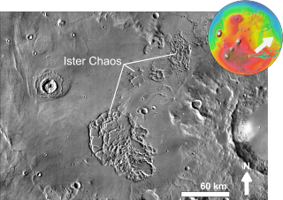
Ister Chaos is a broken up area in the Lunae Palus quadrangle of Mars. It is located at 13.0° N and 56.4° W. It is 103.4 km across and was named after a classical albedo feature at 10N, 56W.

Galaxias Chaos is an area of broken landscape in the Cebrenia quadrangle of Mars, located at 34.1° N and 213.6° W. It is 234.0 km across and was named after an albedo feature name. Galaxias Chaos may be caused by sublimation of an ice-rich deposit.

Nilosyrtis Mensae is an area of Mars in the Casius quadrangle. It is centered on the coordinates of 36.87° N and 67.9° E. Its western and eastern longitudes are 51.1° E and 74.4° E. North and south latitudes are 36.87° N and 29.61° N. Nilosyrtis Mensae is just to the east of Protonilus Mensae and both lie along the Martian dichotomy boundary. Its name was adapted by the IAU in 1973. It was named after a classical albedo feature, and it is 705 km (438 mi) across.
Chaos terrain on Mars is distinctive; nothing on Earth compares to it. Chaos terrain generally consists of irregular groups of large blocks, some tens of kilometers across and a hundred or more meters high. The tilted and flat topped blocks form depressions hundreds of metres deep. A chaotic region can be recognized by a rat's nest of mesas, buttes, and hills, chopped through with valleys which in places look almost patterned. Some parts of this chaotic area have not collapsed completely—they are still formed into large mesas, so they may still contain water ice. Chaos regions formed long ago. By counting craters and by studying the valleys' relations with other geological features, scientists have concluded the channels formed 2.0 to 3.8 billion years ago.
Arsinoes Chaos is a chaos terrain in the Margaritifer Sinus quadrangle on Mars. It is 200 km in diameter. Its location is 7.66 °S and 27.9 °W. Arsinoes Chaos was named after Arsinoe, a queen of ancient Egypt, daughter of Ptolemy and Berenice.
The following outline is provided as an overview of and topical guide to Mars:

Ariadnes Colles is a region of colles (hills) in the northeast of Eridania quadrangle of Mars. It is located around 34.5 ° south latitude, and 172.78° east longitude. It covers 180 by 160 kilometers. The feature was named after a classic albedo feature by the IAU in 1982.
