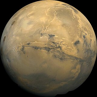
Valles Marineris is a system of canyons that runs along the Martian surface east of the Tharsis region. At more than 4,000 km (2,500 mi) long, 200 km (120 mi) wide and up to 7 km (23,000 ft) deep, Valles Marineris is one of the largest canyons of the Solar System, surpassed in length only by the rift valleys of the mid-ocean ridge system of Earth.
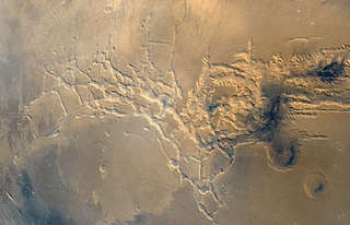
Noctis Labyrinthus is a region of Mars located in the Phoenicis Lacus quadrangle, between Valles Marineris and the Tharsis upland. The region is notable for its maze-like system of deep, steep-walled valleys. The valleys and canyons of this region formed by faulting and many show classic features of grabens, with the upland plain surface preserved on the valley floor. In some places the valley floors are rougher, disturbed by landslides, and there are places where the land appears to have sunk down into pit-like formations. It is thought that this faulting was triggered by volcanic activity in the Tharsis region. Research described in December 2009 found a variety of minerals, including clays, sulfates, and hydrated silicas, in some of the layers.

Galle is a crater on Mars. It is located on the eastern rim of the huge impact basin Argyre Planitia in Argyre quadrangle. It is named after the German astronomer Johann Gottfried Galle. Galle is often known as the "happy face crater" because pareidolia causes a curved mountain range in the southern part of the crater and two smaller mountain clusters further north to appear to be a smiley face. The formation was first photographed by Viking Orbiter 1.

Terra Sirenum is a large region in the southern hemisphere of the planet Mars. It is centered at 39.7°S 150°W and covers 3900 km at its broadest extent. It covers latitudes 10 to 70 South and longitudes 110 to 180 W. Terra Sirenum is an upland area notable for massive cratering including the large Newton Crater. Terra Sirenum is in the Phaethontis quadrangle and the Memnonia quadrangle of Mars. A low area in Terra Sirenum is believed to have once held a lake that eventually drained through Ma'adim Vallis.
Terra Sabaea is a large area on Mars. Its coordinates are 2°N42°E and it covers 4,700 kilometres (2,900 mi) at its broadest extent. It was named in 1979 after a classic albedo feature on the planet. Terra Sabaea is fairly large and parts of it are found in five quadrangles: Arabia quadrangle, Syrtis Major quadrangle, Iapygia quadrangle, Ismenius Lacus quadrangle, and Sinus Sabaeus quadrangle.

Melas Chasma is a canyon on Mars, the widest segment of the Valles Marineris canyon system, located east of Ius Chasma at 9.8°S, 283.6°E in Coprates quadrangle. It cuts through layered deposits that are thought to be sediments from an old lake that resulted from runoff of the valley networks to the west. Other theories include windblown sediment deposits and volcanic ash. Support for abundant, past water in Melas Chasma is the discovery by MRO of hydrated sulfates. In addition, sulfate and iron oxides were found by the same satellite. Although not chosen as one of the finalists, it was one of eight potential landing sites for the Mars 2020 rover, a mission with a focus on astrobiology.

The Ismenius Lacus quadrangle is one of a series of 30 quadrangle maps of Mars used by the United States Geological Survey (USGS) Astrogeology Research Program. The quadrangle is located in the northwestern portion of Mars' eastern hemisphere and covers 0° to 60° east longitude and 30° to 65° north latitude. The quadrangle uses a Lambert conformal conic projection at a nominal scale of 1:5,000,000 (1:5M). The Ismenius Lacus quadrangle is also referred to as MC-5. The southern and northern borders of the Ismenius Lacus quadrangle are approximately 3,065 km (1,905 mi) and 1,500 km (930 mi) wide, respectively. The north-to-south distance is about 2,050 km (1,270 mi). The quadrangle covers an approximate area of 4.9 million square km, or a little over 3% of Mars' surface area. The Ismenius Lacus quadrangle contains parts of Acidalia Planitia, Arabia Terra, Vastitas Borealis, and Terra Sabaea.

The Casius quadrangle is one of a series of 30 quadrangle maps of Mars used by the United States Geological Survey (USGS) Astrogeology Research Program. The quadrangle is located in the north-central portion of Mars’ eastern hemisphere and covers 60° to 120° east longitude and 30° to 65° north latitude. The quadrangle uses a Lambert conformal conic projection at a nominal scale of 1:5,000,000 (1:5M). The Casius quadrangle is also referred to as MC-6. Casius quadrangle contains part of Utopia Planitia and a small part of Terra Sabaea. The southern and northern borders of the Casius quadrangle are approximately 3,065 km and 1,500 km wide, respectively. The north to south distance is about 2,050 km. The quadrangle covers an approximate area of 4.9 million square km, or a little over 3% of Mars’ surface area.
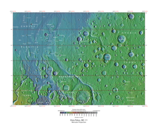
The Oxia Palus quadrangle is one of a series of 30 quadrangle maps of Mars used by the United States Geological Survey (USGS) Astrogeology Research Program. The Oxia Palus quadrangle is also referred to as MC-11.

The Iapygia quadrangle is one of a series of 30 quadrangle maps of Mars used by the United States Geological Survey (USGS) Astrogeology Research Program. The Iapygia quadrangle is also referred to as MC-21.

The Coprates quadrangle is one of a series of 30 quadrangle maps of Mars used by the United States Geological Survey (USGS) Astrogeology Research Program. The Coprates quadrangle is also referred to as MC-18. The Coprates quadrangle contains parts of many of the old classical regions of Mars: Sinai Planum, Solis Planum, Thaumasia Planum, Lunae Planum, Noachis Terra, and Xanthe Terra.

The Margaritifer Sinus quadrangle is one of a series of 30 quadrangle maps of Mars used by the United States Geological Survey (USGS) Astrogeology Research Program. The Margaritifer Sinus quadrangle is also referred to as MC-19. The Margaritifer Sinus quadrangle covers the area from 0° to 45° west longitude and 0° to 30° south latitude on Mars. Margaritifer Sinus quadrangle contains Margaritifer Terra and parts of Xanthe Terra, Noachis Terra, Arabia Terra, and Meridiani Planum.

The Mare Australe quadrangle is one of a series of 30 quadrangle maps of Mars used by the United States Geological Survey (USGS) Astrogeology Research Program. The Mare Australe quadrangle is also referred to as MC-30. The quadrangle covers all the area of Mars south of 65°, including the South polar ice cap, and its surrounding area. The quadrangle's name derives from an older name for a feature that is now called Planum Australe, a large plain surrounding the polar cap. The Mars polar lander crash landed in this region.
Tithonium Chasma is a large canyon in the Coprates quadrangle of Mars at 4.6° south latitude and 84.7° west longitude. It is about 810 km long and was named after a classical albedo feature.
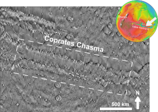
Coprates Chasma is a huge canyon in the Coprates quadrangle of Mars, located at 13.4° south latitude and 61.4° west longitude, part of the Valles Marineris canyon system. It is 966 km (600 mi) long and was named after a classical albedo feature name. It was named from the classical Greek name for the Dez River in Persia.
HiWish is a program created by NASA so that anyone can suggest a place for the HiRISE camera on the Mars Reconnaissance Orbiter to photograph. It was started in January 2010. In the first few months of the program 3000 people signed up to use HiRISE. The first images were released in April 2010. Over 12,000 suggestions were made by the public; suggestions were made for targets in each of the 30 quadrangles of Mars. Selected images released were used for three talks at the 16th Annual International Mars Society Convention. Below are some of the over 4,224 images that have been released from the HiWish program as of March 2016.

The Mars Reconnaissance Orbiter's HiRISE instrument has taken many images that strongly suggest that Mars has had a rich history of water-related processes. Many features of Mars appear to be created by large amounts of water. That Mars once possessed large amounts of water was confirmed by isotope studies in a study published in March 2015, by a team of scientists showing that the ice caps were highly enriched with deuterium, heavy hydrogen, by seven times as much as the Earth. This means that Mars has lost a volume of water 6.5 times what is stored in today's polar caps. The water for a time would have formed an ocean in the low-lying Mare Boreum. The amount of water could have covered the planet about 140 meters, but was probably in an ocean that in places would be almost 1 mile deep.
The common surface features of Mars include dark slope streaks, dust devil tracks, sand dunes, Medusae Fossae Formation, fretted terrain, layers, gullies, glaciers, scalloped topography, chaos terrain, possible ancient rivers, pedestal craters, brain terrain, and ring mold craters.

Firsoff is an impact crater in the region called Meridiani Planum in the Oxia Palus quadrangle of Mars, located at 2.66°N latitude and 9.42°W longitude. It is 90 km in diameter. It was named after British astronomer Axel Firsoff, and the name was approved in 2010.
Crommelin is an impact crater in the Oxia Palus quadrangle of Mars, located at 5.1°N latitude and 10.2°W longitude. It is 113.9 km in diameter. It was named after British astronomer Andrew Crommelin (1865–1939), and the name was approved in 1973 by the International Astronomical Union (IAU) Working Group for Planetary System Nomenclature (WGPSN).
 Wide view of Mars centered on Valles Marineris, taken with Viking images Note, this picture can be greatly enlarged by clicking on it several times.
 Wide view of part of Ius Chasma with the Louros Valles along its southern margin.
 Labeled view of part of Valles Marineris. Colors indicate elevation. The Louros Valles are in the middle left of the image.
 Wide view with CTX image of part of the Louros Valles
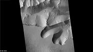 Closer view with CTX image of part of the Louros Valles


 Wide view of layers in the Louros Valles, as seen by HiRISE under HiWish program. The Louros Valles are part of Ius Chasma.
 Close view of layers in the Louros Valles, as seen by HiRISE under HiWish program; this is an enlargement of a previous image.
 Close view of layers in the Louros Valles, as seen by HiRISE under HiWish program; this is an enlargement of a previous image.
 Close view of layers in the Louros Valles, as seen by HiRISE under HiWish program; this is an enlargement of a previous image.
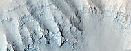 Close view of layers in the Louros Valles, as seen by HiRISE under HiWish program; this is an enlargement of a previous image.


