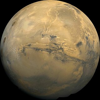
Valles Marineris is a system of canyons that runs along the Martian surface east of the Tharsis region. At more than 4,000 km (2,500 mi) long, 200 km (120 mi) wide and up to 7 km (23,000 ft) deep, Valles Marineris is one of the largest canyons of the Solar System, surpassed in length only by the rift valleys of the mid-ocean ridge system of Earth.
Vallis or valles is the Latin word for valley. It is used in planetary geology to name landform features on other planets.

The Thermal Emission Imaging System (THEMIS) is a camera on board the 2001 Mars Odyssey orbiter. It images Mars in the visible and infrared parts of the electromagnetic spectrum in order to determine the thermal properties of the surface and to refine the distribution of minerals on the surface of Mars as determined by the Thermal Emission Spectrometer (TES). Additionally, it helps scientists to understand how the mineralogy of Mars relates to its landforms, and it can be used to search for thermal hotspots in the Martian subsurface.

Holden is a 140 km wide crater situated within the Margaritifer Sinus quadrangle (MC-19) region of the planet Mars, located with the southern highlands. It is named after American astronomer Edward Singleton Holden. It is part of the Uzboi-Landon-Morava (ULM) system.

Uzboi Vallis is a valley lying situated within the Margaritifer Sinus quadrangle (MC-19) region on Mars. It is named after the Uzboy dry channel, now in Turkmenistan, which repeatedly served as the main channel of the Amu Darya river. The valley begins on the northern rim of the Argyre basin, and cuts through several craters, before ending at Holden crater.

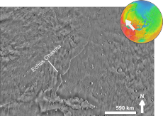
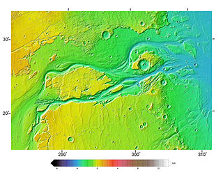
Ares Vallis is an outflow channel on Mars, named after the Greek name for Mars: Ares, the god of war; it appears to have been carved by fluids, perhaps water. The valley 'flows' northwest out of the hilly Margaritifer Terra, where the Iani Chaos depression 180 km (110 mi) long and 200 km (120 mi) wide) is connected to the beginning of Ares Vallis by a 100 km (62 mi) wide transition zone centered on 342.5° East and 3° North. It then continues through the ancient Xanthe Terra highlands, and ends in a delta-like region of Chryse Planitia. Ares Vallis was the landing site of NASA's Mars Pathfinder spacecraft, which studied a region of the valley near the border with Chryse in 1997.

Melas Chasma is a canyon on Mars, the widest segment of the Valles Marineris canyon system, located east of Ius Chasma at 9.8°S, 283.6°E in Coprates quadrangle. It cuts through layered deposits that are thought to be sediments from an old lake that resulted from runoff of the valley networks to the west. Other theories include windblown sediment deposits and volcanic ash. Support for abundant, past water in Melas Chasma is the discovery by MRO of hydrated sulfates. In addition, sulfate and iron oxides were found by the same satellite. Although not chosen as one of the finalists, it was one of eight potential landing sites for the Mars 2020 rover, a mission with a focus on astrobiology.

The Lunae Palus quadrangle is one of a series of 30 quadrangle maps of Mars used by the United States Geological Survey (USGS) Astrogeology Research Program. The quadrangle is also referred to as MC-10. Lunae Planum and parts of Xanthe Terra and Chryse Planitia are found in the Lunae Palus quadrangle. The Lunae Palus quadrangle contains many ancient river valleys.
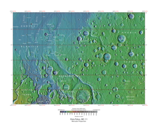
The Oxia Palus quadrangle is one of a series of 30 quadrangle maps of Mars used by the United States Geological Survey (USGS) Astrogeology Research Program. The Oxia Palus quadrangle is also referred to as MC-11.

The Iapygia quadrangle is one of a series of 30 quadrangle maps of Mars used by the United States Geological Survey (USGS) Astrogeology Research Program. The Iapygia quadrangle is also referred to as MC-21.

The Coprates quadrangle is one of a series of 30 quadrangle maps of Mars used by the United States Geological Survey (USGS) Astrogeology Research Program. The Coprates quadrangle is also referred to as MC-18. The Coprates quadrangle contains parts of many of the old classical regions of Mars: Sinai Planum, Solis Planum, Thaumasia Planum, Lunae Planum, Noachis Terra, and Xanthe Terra.

The Margaritifer Sinus quadrangle is one of a series of 30 quadrangle maps of Mars used by the United States Geological Survey (USGS) Astrogeology Research Program. The Margaritifer Sinus quadrangle is also referred to as MC-19. The Margaritifer Sinus quadrangle covers the area from 0° to 45° west longitude and 0° to 30° south latitude on Mars. Margaritifer Sinus quadrangle contains Margaritifer Terra and parts of Xanthe Terra, Noachis Terra, Arabia Terra, and Meridiani Planum.

The Mare Australe quadrangle is one of a series of 30 quadrangle maps of Mars used by the United States Geological Survey (USGS) Astrogeology Research Program. The Mare Australe quadrangle is also referred to as MC-30. The quadrangle covers all the area of Mars south of 65°, including the South polar ice cap, and its surrounding area. The quadrangle's name derives from an older name for a feature that is now called Planum Australe, a large plain surrounding the polar cap. The Mars polar lander crash landed in this region.
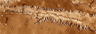
Ius Chasma is a large canyon in the Coprates quadrangle of Mars at 7° south latitude and 85.8° west longitude. It is about 938 km long and was named after a classical albedo feature name.

The Kasei Valles are a giant system of canyons in Mare Acidalium and Lunae Palus quadrangles on Mars, centered at 24.6° north latitude and 65.0° west longitude. They are 1,580 km (980 mi) long and were named for the word for "Mars" in Japanese. This is one of the largest outflow channel systems on Mars.
Outflow channels are extremely long, wide swathes of scoured ground on Mars. They extend many hundreds of kilometers in length and are typically greater than one kilometer in width. They are thought to have been carved by huge outburst floods.
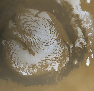
The planet Mars has two permanent polar ice caps. During a pole's winter, it lies in continuous darkness, chilling the surface and causing the deposition of 25–30% of the atmosphere into slabs of CO2 ice (dry ice). When the poles are again exposed to sunlight, the frozen CO2 sublimes. These seasonal actions transport large amounts of dust and water vapor, giving rise to Earth-like frost and large cirrus clouds.
To date, interplanetary spacecraft have provided abundant evidence of water on Mars, dating back to the Mariner 9 mission, which arrived at Mars in 1971. This article provides a mission by mission breakdown of the discoveries they have made. For a more comprehensive description of evidence for water on Mars today, and the history of water on that planet, see Water on Mars.
The Mars orbiter 2001 Mars Odyssey found much evidence for water on Mars in the form of pictures, and with a spectrometer it proved that much of the ground is loaded with ice.

In summer 1965, the first close-up images from Mars showed a cratered desert with no signs of water. However, over the decades, as more parts of the planet were imaged with better cameras on more sophisticated satellites, Mars showed evidence of past river valleys, lakes and present ice in glaciers and in the ground. It was discovered that the climate of Mars displays huge changes over geologic time because its axis is not stabilized by a large moon, as Earth's is. Also, some researchers maintain that surface liquid water could have existed for periods of time due to geothermal effects, chemical composition or asteroid impacts. This article describes some of the places that could have held large lakes.