Vallis or valles is the Latin word for valley. It is used in planetary geology to name landform features on other planets.

Ares Vallis is an outflow channel on Mars, named after the Greek name for Mars: Ares, the god of war; it appears to have been carved by fluids, perhaps water. The valley 'flows' northwest out of the hilly Margaritifer Terra, where the Iani Chaos depression 180 km (110 mi) long and 200 km (120 mi) wide) is connected to the beginning of Ares Vallis by a 100 km (62 mi) wide transition zone centered on 342.5° East and 3° North. It then continues through the ancient Xanthe Terra highlands, and ends in a delta-like region of Chryse Planitia. Ares Vallis was the landing site of NASA's Mars Pathfinder spacecraft, which studied a region of the valley near the border with Chryse in 1997.

The Memnonia quadrangle is one of a series of 30 quadrangle maps of Mars used by the United States Geological Survey (USGS) Astrogeology Research Program. The Memnonia quadrangle is also referred to as MC-16.

Aram Chaos, centered at 2.6°N, 21.5°W, is a heavily eroded impact crater on Mars. It lies at the eastern end of the large canyon Valles Marineris and close to Ares Vallis. Various geological processes have reduced it to a circular area of chaotic terrain. Aram Chaos takes its name from Aram, one of the classical albedo features observed by Giovanni Schiaparelli, who named it after the Biblical land of Aram. Spectroscopic observation from orbit indicates the presence of the mineral hematite, likely a signature of a once aqueous environment.

The Cerberus Fossae are a series of semi-parallel fissures on Mars formed by faults which pulled the crust apart in the Cerberus region. They are 1235 km across and centered at 11.28 °N and 166.37 °E. Their northernmost latitude is 16.16 °N and their southernmost latitude 6.23 °N. Their easternmost and westernmost longitudes are 174.72 °E and 154.43 °E, respectively. They can be seen in the Elysium quadrangle.

The Athabasca Valles are a late Amazonian-period outflow channel system in the central Elysium Planitia region of Mars, located to the south of the Elysium Rise. They are part of a network of outflow channels in this region that are understood to emanate from large fissures in the Martian surface rather than the chaos terrains that source the circum-Chryse outflow channels. The Athabasca Valles in particular emanate from one of the Cerberus Fossae fissures and flow downstream to the southwest, constrained to the south by a wrinkle ridge for over 100 km, before debouching into the Cerberus Palus volcanic plain. The Athabasca Valles are widely understood to be the youngest outflow channel system on the planet.

The Lunae Palus quadrangle is one of a series of 30 quadrangle maps of Mars used by the United States Geological Survey (USGS) Astrogeology Research Program. The quadrangle is also referred to as MC-10. Lunae Planum and parts of Xanthe Terra and Chryse Planitia are found in the Lunae Palus quadrangle. The Lunae Palus quadrangle contains many ancient river valleys.

The Iapygia quadrangle is one of a series of 30 quadrangle maps of Mars used by the United States Geological Survey (USGS) Astrogeology Research Program. The Iapygia quadrangle is also referred to as MC-21. It was named after the heel of the boot of Italy. That name was given by the Greeks It is part of a region of Italy named Apulia. The name Iapygia was approved in 1958.

The Mare Tyrrhenum quadrangle is one of a series of 30 quadrangle maps of Mars used by the United States Geological Survey (USGS) Astrogeology Research Program. This quadrangle is also referred to as MC-22. It contains parts of the regions Tyrrhena Terra, Hesperia Planum, and Terra Cimmeria.

The Coprates quadrangle is one of a series of 30 quadrangle maps of Mars used by the United States Geological Survey (USGS) Astrogeology Research Program. The Coprates quadrangle is also referred to as MC-18. The Coprates quadrangle contains parts of many of the old classical regions of Mars: Sinai Planum, Solis Planum, Thaumasia Planum, Lunae Planum, Noachis Terra, and Xanthe Terra.

The Margaritifer Sinus quadrangle is one of a series of 30 quadrangle maps of Mars used by the United States Geological Survey (USGS) Astrogeology Research Program. The Margaritifer Sinus quadrangle is also referred to as MC-19. The Margaritifer Sinus quadrangle covers the area from 0° to 45° west longitude and 0° to 30° south latitude on Mars. Margaritifer Sinus quadrangle contains Margaritifer Terra and parts of Xanthe Terra, Noachis Terra, Arabia Terra, and Meridiani Planum.

The Thaumasia quadrangle is one of a series of 30 quadrangle maps of Mars used by the United States Geological Survey (USGS) Astrogeology Research Program. The Thaumasia quadrangle is also referred to as MC-25 . The name comes from Thaumas, the god of the clouds and celestial apparitions.

Nirgal Vallis is a long river channel bordering the Coprates quadrangle and Margaritifer Sinus quadrangle of Mars at 28.4° south latitude and 42° west longitude. It is 610 km long and is named after Nergal, the Babylonian god of war and counterpart to the Roman god of war Mars. Nirgal Vallis had a discharge of 4800 cubic meters/second. The western half of Nirgal Valles is a branched system, but the eastern half is a tightly sinuous, deeply entrenched valley. Nirgal Valles ends at Uzboi Vallis. Tributaries are very short and end in steep-walled valley heads, often called "amphitheater-headed valleys." The shape of these valley heads is like cirques on the Earth.

The Kasei Valles are a giant system of canyons in Mare Acidalium and Lunae Palus quadrangles on Mars, centered at 24.6° north latitude and 65.0° west longitude. They are 1,580 km (980 mi) long and were named for the word for "Mars" in Japanese. This is one of the largest outflow channel systems on Mars.
Outflow channels are extremely long, wide swathes of scoured ground on Mars. They extend many hundreds of kilometers in length and are typically greater than one kilometer in width. They are thought to have been carved by huge outburst floods.

Ravi Vallis is an ancient outflow channel, the source of which originates from the Aromatum Chaos depression, and is situated at the eastern end of Xanthe Terra, in the Margaritifer Sinus quadrangle (MC-19) region of Mars, located at 0.2°S 40.7°W. The Ravi Vallis outflow channel is 205.5 km (127.7 mi) long, and starts at the northeastern end of the Aromatum Chaos depression. The channel is orientated in an easterly direction, and further down channel, Ravi Vallis divides into two; a larger northern channel, and a smaller southern channel, and is finally truncated by a fault which is located at the western margin of the Hydraotes Chaos depression. Ravi Vallis was named after the Ravi River, an ancient Indian river.
Chaos terrain on Mars is distinctive; nothing on Earth compares to it. Chaos terrain generally consists of irregular groups of large blocks, some tens of kilometers across and a hundred or more meters high. The tilted and flat topped blocks form depressions hundreds of metres deep. A chaotic region can be recognized by a rat's nest of mesas, buttes, and hills, chopped through with valleys which in places look almost patterned. Some parts of this chaotic area have not collapsed completely—they are still formed into large mesas, so they may still contain water ice. Chaos regions formed long ago. By counting craters and by studying the valleys' relations with other geological features, scientists have concluded the channels formed 2.0 to 3.8 billion years ago.
Aromatum Chaos is a deep depression, in what is considered chaotic terrain. It is the source of the outflow channel Ravi Vallis, and is situated at the eastern end of Xanthe Terra, in the Margaritifer Sinus quadrangle (MC-19) region of Mars, located at 1.09°S 317.0°E. Aromatum Chaos is 91.5 km (56.9 mi) in length, and has an average width of about 30 km (19 mi).

In summer 1965, the first close-up images from Mars showed a cratered desert with no signs of water. However, over the decades, as more parts of the planet were imaged with better cameras on more sophisticated satellites, Mars showed evidence of past river valleys, lakes and present ice in glaciers and in the ground. It was discovered that the climate of Mars displays huge changes over geologic time because its axis is not stabilized by a large moon, as Earth's is. Also, some researchers maintain that surface liquid water could have existed for periods of time due to geothermal effects, chemical composition, or asteroid impacts. This article describes some of the places that could have held large lakes.
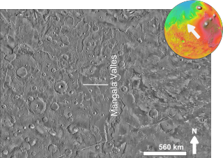
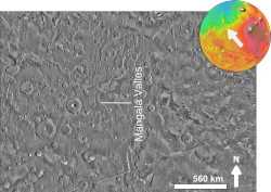
Mangala Fossa is a graben in the Memnonia quadrangle of Mars, located near 11.6°S 151.0°W, which originated in the Hesperian and Amazonian epochs. The graben is located at the head of the outflow channel Mangala Valles, which is thought to have been formed by at least two catastrophic flood events during the same geological period, leading to the release of vast quantities of water from Mangala Fossa onto the Martian surface. The flooding was probably initiated by the emplacement of a dike radiating from the volcano Arsia Mons, resulting in the formation of the graben, Mangala Fossa, at the channels' head. This dike breached a pressurized aquifer trapped beneath a thick "cryosphere" beneath the surface. As the floor of the graben subsided, water found its way up one or both of the faults in the crust that defined the edges of the graben and spilled into the depression, eventually filling it and overflowing at the lowest point on the rim to erode the Mangala Valles channels.