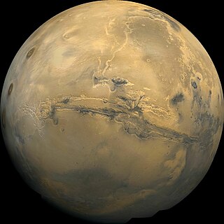
Valles Marineris is a system of canyons that runs along the Martian surface east of the Tharsis region. At more than 4,000 km (2,500 mi) long, 200 km (120 mi) wide and up to 7 km (23,000 ft) deep, Valles Marineris is the largest canyon in the Solar System.

Eos Chasma is a chasma in the southern part of the Valles Marineris canyon system of the Coprates quadrangle and the Margaritifer Sinus quadrangles of the planet Mars.
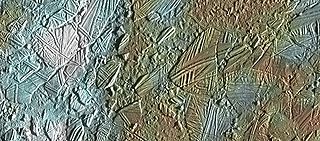
In astrogeology, chaos terrain, or chaotic terrain, is a planetary surface area where features such as ridges, cracks, and plains appear jumbled and enmeshed with one another. Chaos terrain is a notable feature of the planets Mars and Mercury, Jupiter's moon Europa, and the dwarf planet Pluto. In scientific nomenclature, "chaos" is used as a component of proper nouns.
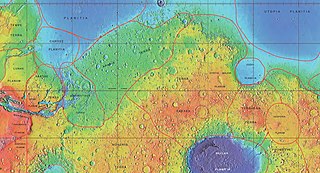
Xanthe Terra is a large area on Mars, centered just north of the Martian equator. Its coordinates are 3°N312°E and its diameter is 1867.65 km. Its name means "golden-yellow land." It is in the Lunae Palus quadrangle, the Coprates quadrangle, the Margaritifer Sinus quadrangle, and the Oxia Palus quadrangle.

Aram Chaos, centered at 2.6°N, 21.5°W, is a heavily eroded impact crater on Mars. It lies at the eastern end of the large canyon Valles Marineris and close to Ares Vallis. Various geological processes have reduced it to a circular area of chaotic terrain. Aram Chaos takes its name from Aram, one of the classical albedo features observed by Giovanni Schiaparelli, who named it after the Biblical land of Aram. Spectroscopic observation from orbit indicates the presence of the mineral hematite, likely a signature of a once aqueous environment.

Melas Chasma is a canyon on Mars, the widest segment of the Valles Marineris canyon system, located east of Ius Chasma at 9.8°S, 283.6°E in Coprates quadrangle. It cuts through layered deposits that are thought to be sediments from an old lake that resulted from runoff of the valley networks to the west. Other theories include windblown sediment deposits and volcanic ash. Support for abundant, past water in Melas Chasma is the discovery by MRO of hydrated sulfates. In addition, sulfate and iron oxides were found by the same satellite. Although not chosen as one of the finalists, it was one of eight potential landing sites for the Mars 2020 rover, a mission with a focus on astrobiology.

The Coprates quadrangle is one of a series of 30 quadrangle maps of Mars used by the United States Geological Survey (USGS) Astrogeology Research Program. The Coprates quadrangle is also referred to as MC-18. The Coprates quadrangle contains parts of many of the old classical regions of Mars: Sinai Planum, Solis Planum, Thaumasia Planum, Lunae Planum, Noachis Terra, and Xanthe Terra.

Eos Chaos is a rough, collapsed area in the Coprates quadrangle on Mars at 16.8° south latitude and 46.9° west longitude. It is about 490 km long and was named after the Greek name of Aurora, an albedo feature.
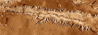
Ius Chasma is a large canyon in the Coprates quadrangle of Mars at 7° south latitude and 85.8° west longitude. It is about 938 km long and was named after a classical albedo feature name.
Tithonium Chasma is a large canyon in the Coprates quadrangle of Mars at 4.6° south latitude and 84.7° west longitude. It is about 810 km long and was named after a classical albedo feature.
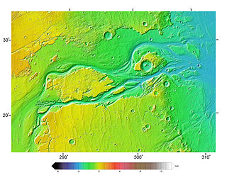
Outflow channels are extremely long, wide swathes of scoured ground on Mars. They extend many hundreds of kilometers in length and are typically greater than one kilometer in width. They are thought to have been carved by huge outburst floods.
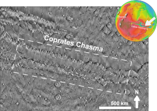
Coprates Chasma is a huge canyon in the Coprates quadrangle of Mars, located at 13.4° south latitude and 61.4° west longitude, part of the Valles Marineris canyon system. It is 966 km (600 mi) long and was named after a classical albedo feature name. It was named from the classical Greek name for the Dez River in Persia.

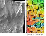
Ganges Mensa is a mesa and an interior layered deposit in Ganges Chasma, one of the peripheral valleys of Valles Marineris on Mars. The mesa rises up to 4 kilometres (13,000 ft) from the floor of Ganges Chasma, nearly to the same elevation as the surrounding plateaux of Lunae Planum. Like Hebes Mensa, the mesa is completely separated from the surrounding canyon walls and has sustained significant erosion that has caused it to retreat in areal extent.

Ravi Vallis is an ancient outflow channel, the source of which originates from the Aromatum Chaos depression, and is situated at the eastern end of Xanthe Terra, in the Margaritifer Sinus quadrangle (MC-19) region of Mars, located at 0.2°S 40.7°W. The Ravi Vallis outflow channel is 205.5 km (127.7 mi) long, and starts at the northeastern end of the Aromatum Chaos depression. The channel is orientated in an easterly direction, and further down channel, Ravi Vallis divides into two; a larger northern channel, and a smaller southern channel, and is finally truncated by a fault which is located at the western margin of the Hydraotes Chaos depression. Ravi Vallis was named after the Ravi River, an ancient Indian river.
To date, interplanetary spacecraft have provided abundant evidence of water on Mars, dating back to the Mariner 9 mission, which arrived at Mars in 1971. This article provides a mission by mission breakdown of the discoveries they have made. For a more comprehensive description of evidence for water on Mars today, and the history of water on that planet, see Water on Mars.
The Mars orbiter 2001 Mars Odyssey found much evidence for water on Mars in the form of pictures, and with a spectrometer it proved that much of the ground is loaded with ice.
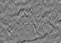
Chaos terrain on Mars is distinctive; nothing on Earth compares to it. Chaos terrain generally consists of irregular groups of large blocks, some tens of kilometers across and a hundred or more meters high. The tilted and flat topped blocks form depressions hundreds of metres deep. A chaotic region can be recognized by a rat's nest of mesas, buttes, and hills, chopped through with valleys which in places look almost patterned. Some parts of this chaotic area have not collapsed completely—they are still formed into large mesas, so they may still contain water ice. Chaos regions formed long ago. By counting craters and by studying the valleys' relations with other geological features, scientists have concluded the channels formed 2.0 to 3.8 billion years ago.

Aromatum Chaos is a deep depression, in what is considered chaotic terrain. It is the source of the outflow channel Ravi Vallis, and is situated at the eastern end of Xanthe Terra, in the Margaritifer Sinus quadrangle (MC-19) region of Mars, located at 1.09°S 317.0°E. Aromatum Chaos is 91.5 km (56.9 mi) in length, and has an average width of about 30 km (19 mi).

In summer 1965, the first close-up images from Mars showed a cratered desert with no signs of water. However, over the decades, as more parts of the planet were imaged with better cameras on more sophisticated satellites, Mars showed evidence of past river valleys, lakes and present ice in glaciers and in the ground. It was discovered that the climate of Mars displays huge changes over geologic time because its axis is not stabilized by a large moon, as Earth's is. Also, some researchers maintain that surface liquid water could have existed for periods of time due to geothermal effects, chemical composition, or asteroid impacts. This article describes some of the places that could have held large lakes.
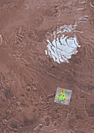
Salty subglacial lakes are controversially inferred from radar measurements to exist below the South Polar Layered Deposits (SPLD) in Ultimi Scopuli of Mars' southern ice cap. The idea of subglacial lakes due to basal melting at the polar ice caps on Mars was first hypothesized in the 1980s. For liquid water to persist below the SPLD, researchers propose that perchlorate is dissolved in the water, which lowers the freezing temperature, but other explanations such as saline ice or hydrous minerals have been offered. Challenges for explaining sufficiently warm conditions for liquid water to exist below the southern ice cap include low amounts of geothermal heating from the subsurface and overlying pressure from the ice. As a result, it is disputed whether radar detections of bright reflectors were instead caused by other materials such as saline ice or deposits of minerals such as clays. While lakes with salt concentrations 20 times that of the ocean pose challenges for life, potential subglacial lakes on Mars are of high interest for astrobiology because microbial ecosystems have been found in deep subglacial lakes on Earth, such as in Lake Whillans in Antarctica below 800 m of ice.
