Terrain softening

Last updated
Softened terrain in Argyre Planitia, 39 degS. Image is around 25 km across. Note the lack of any sharp ridges anywhere in the image. Context image for argyrefeatures.JPG
Softened terrain in Argyre Planitia, 39 °S. Image is around 25 km across. Note the lack of any sharp ridges anywhere in the image.

The landscape polewards of around 30 degrees latitude on Mars has a distinctively different appearance to that nearer the equator, and is said to have undergone terrain softening. Softened terrain lacks the sharp ridge crests seen near the equator, and is instead smoothly rounded. This rounding is thought to be caused by high concentrations of water ice in soils. The term was coined in 1986 by Steve Squyres and Michael Carr from examining imagery from the Viking missions to Mars.

Mars Fourth planet from the Sun in the Solar System

Mars is the fourth planet from the Sun and the second-smallest planet in the Solar System after Mercury. In English, Mars carries a name of the Roman god of war, and is often referred to as the "Red Planet" because the iron oxide prevalent on its surface gives it a reddish appearance that is distinctive among the astronomical bodies visible to the naked eye. Mars is a terrestrial planet with a thin atmosphere, having surface features reminiscent both of the impact craters of the Moon and the valleys, deserts, and polar ice caps of Earth.

Steve Squyres Professor of Physical Sciences at Cornell University

Steven Weldon Squyres is the James A. Weeks Professor of Physical Sciences at Cornell University in Ithaca, New York. His research area is in planetary sciences, with a focus on large solid bodies in the Solar System such as the terrestrial planets and the moons of the Jovian planets. Squyres was the principal investigator of the Mars Exploration Rover Mission (MER). He is the recipient of the 2004 Carl Sagan Memorial Award and the 2009 Carl Sagan Medal for Excellence in Communication in Planetary Science. On October 28, 2010, Squyres received the 2010 Mines Medal for his achievements as a researcher and professor. He is the brother of Academy Award-nominated film editor Tim Squyres.

Viking program Pair of NASA space probes sent to Mars

The Viking program consisted of a pair of American space probes sent to Mars, Viking 1 and Viking 2. Each spacecraft was composed of two main parts: an orbiter designed to photograph the surface of Mars from orbit, and a lander designed to study the planet from the surface. The orbiters also served as communication relays for the landers once they touched down.

Contents

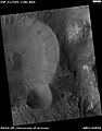
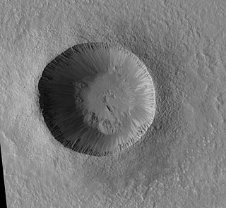
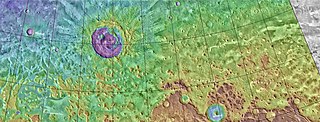
Below 30 degrees of latitude, impact craters have steep walls; well-defined, sharp rims; and flat or smoothly bowl-shaped floors. Ridges on intercrater plains come to similarly well-defined, pointed crests. However, above this latitude, these same features appear very different. The crests seen on ridges and crater rims appear strongly rounded and much more poorly defined. The relief (height) of features is somewhat reduced. Small craters are noticeably less common. In other words, terrain which elsewhere looked sharp here looks "soft". [1] [2] [3] This texture has also been described as "smooth", or "rolling". [4] Softened craters are also commonly infilled with concentric patterns on their floors. [2]

A concentric crater fill is a landform where the floor of a crater is mostly covered with many parallel ridges. It is common in the mid-latitudes of Mars, and is widely believed to be caused by glacial movement. Areas on Mars called Deuteronilus Mensae and Protonilus Mensae contain many examples of concentric crater fill.

On Earth, diffusive creep of soils is associated with rounded hillslopes. [5] [6] Squyres and Carr thus attributed the softened texture to accelerated viscous creep in shallow soils near the surface, and went on to associate this accelerated creep with the presence of ground ice at these latitudes. [1] This conclusion has been largely borne out by subsequent research. [2] [7] In the late 1980s some attempts were made to link terrain softening with dust and aeolian processes, [8] [9] though this hypothesis has largely been superseded by more recent observations. [2]

Diffusion net movement of molecules or atoms from a region of high concentration (or high chemical potential) to a region of low concentration (or low chemical potential)

Diffusion is net movement of anything from a region of higher concentration to a region of lower concentration. Diffusion is driven by a gradient in concentration.

Downhill creep

Downhill creep, also known as soil creep or commonly just creep, is the slow downward progression of rock and soil down a low grade slope; it can also refer to slow deformation of such materials as a result of prolonged pressure and stress. Creep may appear to an observer to be continuous, but it really is the sum of numerous minute, discrete movements of slope material caused by the force of gravity. Friction, being the primary force to resist gravity, is produced when one body of material slides past another offering a mechanical resistance between the two which acts to hold objects in place. As slope on a hill increases, the gravitational force that is perpendicular to the slope decreases and results in less friction between the material that could cause the slope to slide.

Aeolian processes Processes due to wind activity

Aeolian processes, also spelled eolian or æolian, pertain to wind activity in the study of geology and weather and specifically to the wind's ability to shape the surface of the Earth. Winds may erode, transport, and deposit materials and are effective agents in regions with sparse vegetation, a lack of soil moisture and a large supply of unconsolidated sediments. Although water is a much more powerful eroding force than wind, aeolian processes are important in arid environments such as deserts.

Terrain softening is one of a suite of features seen in the midlatitudes of Mars—also including lobate debris aprons, lineated valley fill, concentric crater fill, latitude dependent mantle, patterned ground, viscous flow features, arcuate ridges, recurring slope lineae, and gullies—whose form and distribution strongly suggest the abundance of ice at the surface. [2]

Lobate debris apron

Lobate debris aprons (LDAs) are geological features on Mars, first seen by the Viking Orbiters, consisting of piles of rock debris below cliffs. These features have a convex topography and a gentle slope from cliffs or escarpments, which suggest flow away from the steep source cliff. In addition, lobate debris aprons can show surface lineations as do rock glaciers on the Earth.

Lineated valley fill

Lineated valley fill (LVF), also called lineated floor deposit, is a feature of the floors of some channels on Mars, exhibiting ridges and grooves that seem to flow around obstacles. Shadow measurements show that at least some of the ridges are several metres high. LVF is believed to be ice-rich. Hundreds of metres of ice probably lie protected in LVF under a thin layer of debris. The debris consists of wind-borne dust, material from alcove walls, and lag material remaining after ice sublimated from a rock-ice mixture. Some glaciers on Earth show similar ridges. High-resolution pictures taken with HiRISE reveal that some of the surfaces of lineated valley fill are covered with strange patterns called closed-cell and open-cell brain terrain. The terrain resembles a human brain. It is believed to be caused by cracks in the surface accumulating dust and other debris, together with ice sublimating from some of the surfaces. The cracks are the result stress from gravity and seasonal heating and cooling. This same type of surface is present on Lobate debris aprons and Concentric crater fill so all three are believed to be related.

Patterned ground

Patterned ground is the distinct and often symmetrical natural pattern of geometric shapes formed by ground material in periglacial regions. Typically found in remote regions of the Arctic, Antarctica, and the Australian outback but also found anywhere that freezing and thawing of soil alternate; patterned ground has also been observed on Mars. The geometric shapes and patterns associated with patterned ground are often mistaken as artistic human creations. The mechanism of the formation of patterned ground had long puzzled scientists but the introduction of computer-generated geological models in the past 20 years has allowed scientists to relate it to frost heaving, the expansion that occurs when wet, fine-grained, and porous soils freeze.

Contrast between softened and unsoftened terrain

Unsoftened terrain
Zumba (crater) crater on Mars

Zumba is a very young crater on Mars, located in the Phoenicis Lacus quadrangle at 28.68 South and 133.18 West. It only measures approximately 3 kilometres in diameter and was named after the town of Zumba in Ecuador. The name was adopted by IAU's Working Group for Planetary System Nomenclature in 2006.

Saheki (crater) crater on Mars

Saheki is a crater on Mars, located in the Iapygia quadrangle at 21.75° S and 286.97° W. It measures approximately 82 kilometers in diameter and was named after Tsuneo Saheki, a Japanese amateur astronomer (1916–1996). The naming was adopted by IAU's Working Group for Planetary System Nomenclature in 2006.

Arabia Terra large upland region in the north of Mars

Arabia Terra is a large upland region in the north of Mars that lies mostly in the Arabia quadrangle, but a small part is in the Mare Acidalium quadrangle. It is densely cratered and heavily eroded. This battered topography indicates great age, and Arabia Terra is presumed to be one of the oldest terrains on the planet. It covers as much as 4,500 km (2,800 mi) at its longest extent, centered roughly at 21°N6°E with its eastern and southern regions rising 4 km (13,000 ft) above the north-west. Alongside its many craters, canyons wind through the Arabia Terra, many emptying into the large northern lowlands of the planet, which borders Arabia Terra to the north.

Softened terrain
Eridania quadrangle

The Eridania quadrangle is one of a series of 30 quadrangle maps of Mars used by the United States Geological Survey (USGS) Astrogeology Research Program. The Eridania quadrangle is also referred to as MC-29.

See also

Related Research Articles

Terra Sabaea terra on Mars

Terra Sabaea is a large area on Mars. Its coordinates are 2°N42°E and it covers 4,700 kilometres (2,900 mi) at its broadest extent. It was named in 1979 after a classic albedo feature on the planet. Terra Sabaea is fairly large and parts of it are found in five quadrangles: Arabia quadrangle, Syrtis Major quadrangle, Iapygia quadrangle, Ismenius Lacus quadrangle, and Sinus Sabaeus quadrangle.

Deuteronilus Mensae mensae on Mars

Deuteronilus Mensae is a region on Mars 937 km across and centered at 43.9°N 337.4°W. It covers 344°–325° West and 40°–48° North. Deuteronilus region lies just to the north of Arabia Terra and is included in the Ismenius Lacus quadrangle. It is along the dichotomy boundary, that is between the old, heavily cratered southern highlands and the low plains of the northern hemisphere. The region contains flat-topped knobby terrain that may have been formed by glaciers at some time in the past. Deuteronilus Mensae is to the immediate west of Protonilus Mensae and Ismeniae Fossae. Glaciers persist in the region in modern times, with at least one glacier estimated to have formed as recently as 100,000 to 10,000 years ago. Recent evidence from the radar on the Mars Reconnaissance Orbiter has shown that parts of Deuteronilus Mensae do indeed contain ice.

Noachis quadrangle

The Noachis quadrangle is one of a series of 30 quadrangle maps of Mars used by the United States Geological Survey (USGS) Astrogeology Research Program. The Noachis quadrangle is also referred to as MC-27.

Ismenius Lacus quadrangle

The Ismenius Lacus quadrangle is one of a series of 30 quadrangle maps of Mars used by the United States Geological Survey (USGS) Astrogeology Research Program. The quadrangle is located in the northwestern portion of Mars’ eastern hemisphere and covers 0° to 60° east longitude and 30° to 65° north latitude. The quadrangle uses a Lambert conformal conic projection at a nominal scale of 1:5,000,000 (1:5M). The Ismenius Lacus quadrangle is also referred to as MC-5. The southern and northern borders of the Ismenius Lacus quadrangle are approximately 3,065 km (1,905 mi) and 1,500 km (930 mi) wide, respectively. The north-to-south distance is about 2,050 km (1,270 mi). The quadrangle covers an approximate area of 4.9 million square km, or a little over 3% of Mars’ surface area. The Ismenius Lacus quadrangle contains parts of Acidalia Planitia, Arabia Terra, Vastitas Borealis, and Terra Sabaea.

Casius quadrangle quadrangle region on Mars

The Casius quadrangle is one of a series of 30 quadrangle maps of Mars used by the United States Geological Survey (USGS) Astrogeology Research Program. The quadrangle is located in the north-central portion of Mars’ eastern hemisphere and covers 60° to 120° east longitude and 30° to 65° north latitude. The quadrangle uses a Lambert conformal conic projection at a nominal scale of 1:5,000,000 (1:5M). The Casius quadrangle is also referred to as MC-6. Casius quadrangle contains part of Utopia Planitia and a small part of Terra Sabaea. The southern and northern borders of the Casius quadrangle are approximately 3,065 km and 1,500 km wide, respectively. The north to south distance is about 2,050 km. The quadrangle covers an approximate area of 4.9 million square km, or a little over 3% of Mars’ surface area.

Cebrenia quadrangle

The Cebrenia quadrangle is one of a series of 30 quadrangle maps of Mars used by the United States Geological Survey (USGS) Astrogeology Research Program. The quadrangle is located in the northeastern portion of Mars’ eastern hemisphere and covers 120° to 180° east longitude and 30° to 65° north latitude. The quadrangle uses a Lambert conformal conic projection at a nominal scale of 1:5,000,000 (1:5M). The Cebrenia quadrangle is also referred to as MC-7. It includes part of Utopia Planitia and Arcadia Planitia. The southern and northern borders of the Cebrenia quadrangle are approximately 3,065 km (1,905 mi) and 1,500 km (930 mi) wide, respectively. The north to south distance is about 2,050 km (1,270 mi). The quadrangle covers an approximate area of 4.9 million square km, or a little over 3% of Mars’ surface area.

Arcadia quadrangle

The Arcadia quadrangle is one of a series of 30 quadrangle maps of Mars used by the United States Geological Survey (USGS) Astrogeology Research Program. The quadrangle is located in the north-central portion of Mars’ western hemisphere and covers 240° to 300° east longitude and 30° to 65° north latitude. The quadrangle uses a Lambert conformal conic projection at a nominal scale of 1:5,000,000 (1:5M). The Arcadia quadrangle is also referred to as MC-3.

Hellas quadrangle quadrangle on Mars

The Hellas quadrangle is one of a series of 30 quadrangle maps of Mars used by the United States Geological Survey (USGS) Astrogeology Research Program. The Hellas quadrangle is also referred to as MC-28 . The Hellas quadrangle covers the area from 240° to 300° west longitude and 30° to 65° south latitude on the planet Mars. Within the Hellas quadrangle lies the classic features Hellas Planitia and Promethei Terra. Many interesting and mysterious features have been discovered in the Hellas quadrangle, including the giant river valleys Dao Vallis, Niger Vallis, Harmakhis, and Reull Vallis—all of which may have contributed water to a lake in the Hellas basin in the distant past. Many places in the Hellas quadrangle show signs of ice in the ground, especially places with glacier-like flow features.

Phaethontis quadrangle

The Phaethontis quadrangle is one of a series of 30 quadrangle maps of Mars used by the United States Geological Survey (USGS) Astrogeology Research Program. The Phaethontis quadrangle is also referred to as MC-24.

Phlegra Montes montes on Mars

The Phlegra Montes are a system of eroded Hesperian–Noachian-aged massifs and knobby terrain in the mid-latitudes of the northern lowlands of Mars, extending northwards from the Elysium Rise towards Vastitas Borealis for nearly 1,400 km (870 mi). The mountain ranges separate the large plains provinces of Utopia Planitia (west) and Amazonis Planitia (east), and were named in the 1970s after a classical albedo feature. The massif terrains are flanked by numerous parallel wrinkle ridges known as the Phlegra Dorsa.

Lipik (crater) crater on Mars

Lipik Crater is a crater in the Hellas quadrangle of Mars, located at 38.42° S and 248.43° W. It is 56 km in diameter and was named after Lipik, a town in Croatia. Close-up pictures of the crater show glacial features. The crater is not very deep, so much ice and dust may have accumulated over the years. If one measures the diameter of a crater, the original depth can be estimated with various ratios. Because of this relationship, researchers have found that many Martian craters contain a great deal of material; much of it is believed to be ice deposited when the climate was different.

Protonilus Mensae

Protonilus Mensae is an area of Mars in the Ismenius Lacus quadrangle. It is centered on the coordinates of 43.86° N and 49.4° E. Its western and eastern longitudes are 37° E and 59.7° E. North and south latitudes are 47.06° N and 39.87° N. Protonilus Mensae is between Deuteronilus Mensae and Nilosyrtis Mensae; all lie along the Martian dichotomy boundary. Its name was adapted by the IAU in 1973.

Nilosyrtis Mensae mensae on Mars

Nilosyrtis Mensae is an area of Mars in the Casius quadrangle. It is centered on the coordinates of 36.87° N and 67.9° E. Its western and eastern longitudes are 51.1° E and 74.4° E. North and south latitudes are 36.87° N and 29.61° N. Nilosyrtis Mensae is just to the east of Protonilus Mensae and both lie along the Martian dichotomy boundary. Its name was adapted by the IAU in 1973. It was named after a classical albedo feature, and it is 705 km (438 mi) across.

Denning (Martian crater) crater on Mars

Denning Crater is a large Noachian-age impact crater in the southwestern Terra Sabaea region of the southern Martian highlands, within the Sinus Sabaeus quadrangle. It is located to the northwest of the Hellas impact basin within the furthest outskirts of the Hellas debris apron. The crater is 165 km in diameter and likely formed during the Late Heavy Bombardment, a period of intense bolide impacts affecting the entirety of the Solar System; during the Hesperian period, aeolian processes caused significant degradation of the crater's rim features and infilled the crater's floor. Similar to other large craters in this region of Mars, wind-eroded features are sporadically found on the basin floor. The presence of wrinkle ridges of varying orientations within and around the Denning basin has been correlated to regional tectonic events, including the formation of the Hellas basin itself. The crater was named for British astronomer William Frederick Denning.

Glaciers on Mars

Glaciers, loosely defined as patches of currently or recently flowing ice, are thought to be present across large but restricted areas of the modern Martian surface, and are inferred to have been more widely distributed at times in the past. Lobate convex features on the surface known as viscous flow features and lobate debris aprons, which show the characteristics of non-Newtonian flow, are now almost unanimously regarded as true glaciers.

Chaos terrain on Mars is distinctive; nothing on Earth compares to it. Chaos terrain generally consists of irregular groups of large blocks, some tens of kilometers across and a hundred or more meters high. The tilted and flat topped blocks form depressions hundreds of metres deep. A chaotic region can be recognized by a rat's nest of mesas, buttes, and hills, chopped through with valleys which in places look almost patterned. Some parts of this chaotic area have not collapsed completely—they are still formed into large mesas, so they may still contain water ice. Chaos regions formed long ago. By counting craters and by studying the valleys' relations with other geological features, scientists have concluded the channels formed 2.0 to 3.8 billion years ago.

Brain terrain terrain on Mars

Brain terrain, also called knobs-brain coral and brain coral terrain, is a feature of the Martian surface, consisting of complex ridges found on lobate debris aprons, lineated valley fill and concentric crater fill. It is so named because it suggests the ridges on the surface of the human brain. Wide ridges are called closed-cell brain terrain, and the less common narrow ridges are called open-cell brain terrain. It is thought that the wide closed-cell terrain contains a core of ice, and when the ice disappears the center of the wide ridge collapses to produce the narrow ridges of the open-cell brain terrain. Shadow measurements from HiRISE indicate the ridges are 4-5 meters high. Brain terrain has been observed to form from what has been called an "Upper Plains Unit." The process begins with the formation of stress cracks. The upper plains unit fell from the sky as snow and as ice coated dust.

References

  1. 1 2 Squyres, Steven W., and Michael H. Carr. "Geomorphic evidence for the distribution of ground ice on Mars." Science 231.4735 (1986): 249-252.
  2. 1 2 3 4 5 Carr, Michael H. The surface of Mars. Vol. 6. Cambridge University Press, 2006.
  3. Zimbelman, James R. "Spatial resolution and the geologic interpretation of Martian morphology: Implications for subsurface volatiles." Icarus 71.2 (1987): 257-267.
  4. Jankowski, David G., and Steven W. Squyres. "The topography of impact craters in “softened” terrain on Mars." Icarus 100.1 (1992): 26-39.
  5. Roering, Joshua J., James W. Kirchner, and William E. Dietrich. "Evidence for nonlinear, diffusive sediment transport on hillslopes and implications for landscape morphology." Water Resources Research 35.3 (1999): 853-870.
  6. Rosenbloom, N. A., and Robert S. Anderson. "Hillslope and channel evolution in a marine terraced landscape, Santa Cruz." California: Journal of Geophysical Research 99.B7 (1994): 14-013.
  7. Berman, Daniel C., David A. Crown, and Leslie F. Bleamaster III. "Degradation of mid-latitude craters on Mars." Icarus 200.1 (2009): 77-95.
  8. Zimbelman, J. R., S. M. Clifford, and S. H. Williams. "Terrain Softening Revisited: Photogeological Considerations." Lunar and Planetary Institute Science Conference Abstracts. Vol. 19. 1988.
  9. Clifford, S. M., and J. R. Zimbelman. "Softened Terrain on Mars: The Ground Ice Interpretation Reconsidered." Lunar and Planetary Institute Science Conference Abstracts. Vol. 19. 1988.