Vallis or valles is the Latin word for valley. It is used in planetary geology to name landform features on other planets.

Argyre Planitia is a plain located within the impact basin Argyre in the southern highlands of Mars. Its name comes from a map produced by Giovanni Schiaparelli in 1877; it refers to Argyre, a mythical island of silver in Greek mythology.

Holden is a 140 km wide crater situated within the Margaritifer Sinus quadrangle (MC-19) region of the planet Mars, located with the southern highlands. It is named after American astronomer Edward Singleton Holden. It is part of the Uzboi-Landon-Morava (ULM) system.

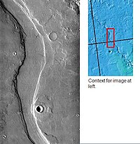
Uzboi Vallis is a valley lying situated within the Margaritifer Sinus quadrangle (MC-19) region on Mars. It is named after the Uzboy dry channel, now in Turkmenistan, which repeatedly served as the main channel of the Amu Darya river. The valley begins on the northern rim of the Argyre basin, and cuts through several craters, before ending at Holden crater.

The Memnonia quadrangle is one of a series of 30 quadrangle maps of Mars used by the United States Geological Survey (USGS) Astrogeology Research Program. The Memnonia quadrangle is also referred to as MC-16.
Reull Vallis is a valley on Mars that appears to have been carved by water. It runs westward into Hellas Planitia. It is named after the Gaelic word for planet. It is found in the Hellas quadrangle.

The Cebrenia quadrangle is one of a series of 30 quadrangle maps of Mars used by the United States Geological Survey (USGS) Astrogeology Research Program. The quadrangle is located in the northeastern portion of Mars' eastern hemisphere and covers 120° to 180° east longitude and 30° to 65° north latitude. The quadrangle uses a Lambert conformal conic projection at a nominal scale of 1:5,000,000 (1:5M). The Cebrenia quadrangle is also referred to as MC-7. It includes part of Utopia Planitia and Arcadia Planitia. The southern and northern borders of the Cebrenia quadrangle are approximately 3,065 km (1,905 mi) and 1,500 km (930 mi) wide, respectively. The north to south distance is about 2,050 km (1,270 mi). The quadrangle covers an approximate area of 4.9 million square km, or a little over 3% of Mars' surface area.
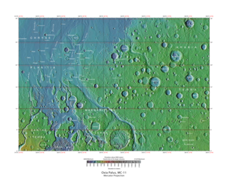
The Oxia Palus quadrangle is one of a series of 30 quadrangle maps of Mars used by the United States Geological Survey (USGS) Astrogeology Research Program. The Oxia Palus quadrangle is also referred to as MC-11.

The Iapygia quadrangle is one of a series of 30 quadrangle maps of Mars used by the United States Geological Survey (USGS) Astrogeology Research Program. The Iapygia quadrangle is also referred to as MC-21. It was named after the heel of the boot of Italy. That name was given by the Greeks It is part of a region of Italy named Apulia. The name Iapygia was approved in 1958.

The Mare Tyrrhenum quadrangle is one of a series of 30 quadrangle maps of Mars used by the United States Geological Survey (USGS) Astrogeology Research Program. This quadrangle is also referred to as MC-22. It contains parts of the regions Tyrrhena Terra, Hesperia Planum, and Terra Cimmeria.

The Coprates quadrangle is one of a series of 30 quadrangle maps of Mars used by the United States Geological Survey (USGS) Astrogeology Research Program. The Coprates quadrangle is also referred to as MC-18. The Coprates quadrangle contains parts of many of the old classical regions of Mars: Sinai Planum, Solis Planum, Thaumasia Planum, Lunae Planum, Noachis Terra, and Xanthe Terra.

The Margaritifer Sinus quadrangle is one of a series of 30 quadrangle maps of Mars used by the United States Geological Survey (USGS) Astrogeology Research Program. The Margaritifer Sinus quadrangle is also referred to as MC-19. The Margaritifer Sinus quadrangle covers the area from 0° to 45° west longitude and 0° to 30° south latitude on Mars. Margaritifer Sinus quadrangle contains Margaritifer Terra and parts of Xanthe Terra, Noachis Terra, Arabia Terra, and Meridiani Planum.

The Hellas quadrangle is one of a series of 30 quadrangle maps of Mars used by the United States Geological Survey (USGS) Astrogeology Research Program. The Hellas quadrangle is also referred to as MC-28 . The Hellas quadrangle covers the area from 240° to 300° west longitude and 30° to 65° south latitude on the planet Mars. Within the Hellas quadrangle lies the classic features Hellas Planitia and Promethei Terra. Many interesting and mysterious features have been discovered in the Hellas quadrangle, including the giant river valleys Dao Vallis, Niger Vallis, Harmakhis, and Reull Vallis—all of which may have contributed water to a lake in the Hellas basin in the distant past. Many places in the Hellas quadrangle show signs of ice in the ground, especially places with glacier-like flow features.
Shalbatana Vallis is an ancient water-worn channel on Mars, located in the Oxia Palus quadrangle at 7.8° north latitude and 42.1° west longitude. It is the westernmost of the southern Chryse outflow channels. Beginning in a zone of chaotic terrain, at 0° latitude and 46° W longitude, it ends in Chryse Planitia.

Nirgal Vallis is a long river channel bordering the Coprates quadrangle and Margaritifer Sinus quadrangle of Mars at 28.4° south latitude and 42° west longitude. It is 610 km long and is named after Nergal, the Babylonian god of war and counterpart to the Roman god of war Mars. Nirgal Vallis had a discharge of 4800 cubic meters/second. The western half of Nirgal Valles is a branched system, but the eastern half is a tightly sinuous, deeply entrenched valley. Nirgal Valles ends at Uzboi Vallis. Tributaries are very short and end in steep-walled valley heads, often called "amphitheater-headed valleys." The shape of these valley heads is like cirques on the Earth.
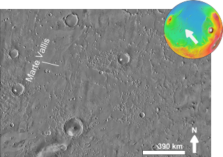
Marte Vallis is a valley in the Amazonis quadrangle of Mars, located at 15 North and 176.5 West. It is 185 km long and was named for the Spanish word for "Mars". It has been identified as an outflow channel, carved in the geological past by catastrophic release of water from aquifers beneath the Martian surface. The surface material is thought to have been created out of 'a'ā and pāhoehoe lava flows from the Elysium volcanic province in the west.

The Ladon Valles are a river valley system lying within the Margaritifer Sinus quadrangle (MC-19) region of the planet Mars located at 22.6° South and 28.7° West. They are 278 km long and were named after an ancient name for a Greek river.

Ravi Vallis is an ancient outflow channel, the source of which originates from the Aromatum Chaos depression, and is situated at the eastern end of Xanthe Terra, in the Margaritifer Sinus quadrangle (MC-19) region of Mars, located at 0.2°S 40.7°W. The Ravi Vallis outflow channel is 205.5 km (127.7 mi) long, and starts at the northeastern end of the Aromatum Chaos depression. The channel is orientated in an easterly direction, and further down channel, Ravi Vallis divides into two; a larger northern channel, and a smaller southern channel, and is finally truncated by a fault which is located at the western margin of the Hydraotes Chaos depression. Ravi Vallis was named after the Ravi River, an ancient Indian river.

Galaxias Chaos is an area of broken landscape in the Cebrenia quadrangle of Mars, located at 34.1° N and 213.6° W. It is 234.0 km across and was named after an albedo feature name. Galaxias Chaos may be caused by sublimation of an ice-rich deposit.
Chaos terrain on Mars is distinctive; nothing on Earth compares to it. Chaos terrain generally consists of irregular groups of large blocks, some tens of kilometers across and a hundred or more meters high. The tilted and flat topped blocks form depressions hundreds of metres deep. A chaotic region can be recognized by a rat's nest of mesas, buttes, and hills, chopped through with valleys which in places look almost patterned. Some parts of this chaotic area have not collapsed completely—they are still formed into large mesas, so they may still contain water ice. Chaos regions formed long ago. By counting craters and by studying the valleys' relations with other geological features, scientists have concluded the channels formed 2.0 to 3.8 billion years ago.