Tharsis is a vast volcanic plateau centered near the equator in the western hemisphere of Mars. The region is home to the largest volcanoes in the Solar System, including the three enormous shield volcanoes Arsia Mons, Pavonis Mons, and Ascraeus Mons, which are collectively known as the Tharsis Montes. The tallest volcano on the planet, Olympus Mons, is often associated with the Tharsis region but is actually located off the western edge of the plateau. The name Tharsis is the Greco-Latin transliteration of the biblical Tarshish, the land at the western extremity of the known world.

Pavonis Mons is a large shield volcano located in the Tharsis region of the planet Mars. It is the middle member of a chain of three volcanic mountains that straddle the Martian equator between longitudes 235°E and 259°E. The volcano was discovered by the Mariner 9 spacecraft in 1971, and was originally called Middle Spot. Its name formally became Pavonis Mons in 1973. The equatorial location of its peak and its height make it the ideal terminus for a space elevator, and it has often been proposed as a space elevator location, especially in science fiction. It is also an ideal location for a Sky Ramp.

Ascraeus Mons is a large shield volcano located in the Tharsis region of the planet Mars. It is the northernmost and tallest of three shield volcanoes collectively known as the Tharsis Montes.
In planetary nomenclature, a fossa is a long, narrow depression (trough) on the surface of an extraterrestrial body, such as a planet or moon. The term, which means "ditch" or "trench" in Latin, is not a geological term as such but a descriptor term used by the United States Geological Survey (USGS) and the International Astronomical Union (IAU) for topographic features whose geology or geomorphology is uncertain due to lack of data or knowledge of the exact processes that formed them. Fossae are believed to be the result of a number of geological processes, such as faulting or subsidence. Many fossae on Mars are probably graben.

Alba Mons is a volcano located in the northern Tharsis region of the planet Mars. It is the biggest volcano on Mars in terms of surface area, with volcanic flow fields that extend for at least 1,350 km (840 mi) from its summit. Although the volcano has a span comparable to that of the United States, it reaches an elevation of only 6.8 km (22,000 ft) at its highest point. This is about one-third the height of Olympus Mons, the tallest volcano on the planet. The flanks of Alba Mons have very gentle slopes. The average slope along the volcano's northern flank is 0.5°, which is over five times lower than the slopes on the other large Tharsis volcanoes. In broad profile, Alba Mons resembles a vast but barely raised welt on the planet's surface. It is a unique volcanic structure with no counterpart on Earth or elsewhere on Mars.
Arabia Terra is a large upland region in the north of Mars that lies mostly in the Arabia quadrangle, but a small part is in the Mare Acidalium quadrangle. It is densely cratered and heavily eroded. This battered topography indicates great age, and Arabia Terra is presumed to be one of the oldest terrains on the planet. It covers as much as 4,500 km (2,800 mi) at its longest extent, centered roughly at 21°N6°E with its eastern and southern regions rising 4 km (13,000 ft) above the north-west. Alongside its many craters, canyons wind through the Arabia Terra, many emptying into the large northern lowlands of the planet, which borders Arabia Terra to the north.

Tempe Terra is a heavily cratered highland region in the northern hemisphere of the planet Mars. Located at the northeastern edge of the Tharsis volcanic province, Tempe Terra is notable for its high degree of crustal fracturing and deformation. The region also contains many small shield volcanoes, lava flows, and other volcanic structures.

The geology of Mars is the scientific study of the surface, crust, and interior of the planet Mars. It emphasizes the composition, structure, history, and physical processes that shape the planet. It is analogous to the field of terrestrial geology. In planetary science, the term geology is used in its broadest sense to mean the study of the solid parts of planets and moons. The term incorporates aspects of geophysics, geochemistry, mineralogy, geodesy, and cartography. A neologism, areology, from the Greek word Arēs (Mars), sometimes appears as a synonym for Mars's geology in the popular media and works of science fiction. The term areology is also used by the Areological Society.
Volcanic activity, or volcanism, has played a significant role in the geologic evolution of Mars. Scientists have known since the Mariner 9 mission in 1972 that volcanic features cover large portions of the Martian surface. These features include extensive lava flows, vast lava plains, and the largest known volcanoes in the Solar System. Martian volcanic features range in age from Noachian to late Amazonian, indicating that the planet has been volcanically active throughout its history, and some speculate it probably still is so today. Both Earth and Mars are large, differentiated planets built from similar chondritic materials. Many of the same magmatic processes that occur on Earth also occurred on Mars, and both planets are similar enough compositionally that the same names can be applied to their igneous rocks and minerals.

Tharsis Tholus is an intermediate-sized shield volcano located in the eastern Tharsis region of the planet Mars. The volcano was discovered by the Mariner 9 spacecraft in 1972 and originally given the informal name Volcano 7. In 1973, the International Astronomical Union (IAU) officially designated it Tharsis Tholus. In planetary geology, tholus is the term for a small domical mountain, usually a volcano.

The Diacria quadrangle is one of a series of 30 quadrangle maps of Mars used by the United States Geological Survey (USGS) Astrogeology Research Program. The quadrangle is located in the northwestern portion of Mars' western hemisphere and covers 180° to 240° east longitude and 30° to 65° north latitude. The quadrangle uses a Lambert conformal conic projection at a nominal scale of 1:5,000,000 (1:5M). The Diacria quadrangle is also referred to as MC-2. The Diacria quadrangle covers parts of Arcadia Planitia and Amazonis Planitia.

The Arcadia quadrangle is one of a series of 30 quadrangle maps of Mars used by the United States Geological Survey (USGS) Astrogeology Research Program. The quadrangle is located in the north-central portion of Mars’ western hemisphere and covers 240° to 300° east longitude and 30° to 65° north latitude. The quadrangle uses a Lambert conformal conic projection at a nominal scale of 1:5,000,000 (1:5M). The Arcadia quadrangle is also referred to as MC-3.

The Elysium quadrangle is one of a series of 30 quadrangle maps of Mars used by the United States Geological Survey (USGS) Astrogeology Research Program. The Elysium quadrangle is also referred to as MC-15.

The Tharsis quadrangle is one of a series of 30 quadrangle maps of Mars used by the United States Geological Survey (USGS) Astrogeology Research Program. The Tharsis quadrangle is also referred to as MC-9 . The name Tharsis refers to a land mentioned in the Bible. It may be at the location of the old town of Tartessus at the mouth of Guadalquivir.

The Mare Tyrrhenum quadrangle is one of a series of 30 quadrangle maps of Mars used by the United States Geological Survey (USGS) Astrogeology Research Program. This quadrangle is also referred to as MC-22. It contains parts of the regions Tyrrhena Terra, Hesperia Planum, and Terra Cimmeria.

The Phoenicis Lacus quadrangle is one of a series of 30 quadrangle maps of Mars used by the United States Geological Survey (USGS) Astrogeology Research Program. The Phoenicis Lacus quadrangle is also referred to as MC-17. Parts of Daedalia Planum, Sinai Planum, and Solis Planum are found in this quadrangle. Phoenicis Lacus is named after the phoenix which according to myth burns itself up every 500 years and then is reborn.
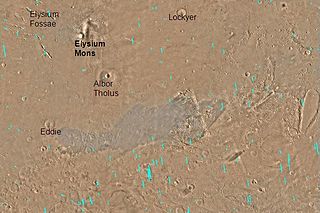
The Elysium Fossae are a group of large troughs in the Elysium quadrangle of Mars at 24.8° north latitude and 213.7° west longitude. They are about 1,175 km long and are named after a classical albedo feature name.

Enipeus Vallis is a valley in the northern hemisphere of the planet Mars. It is centered at lat. 37°N, long. 267°E in the Arcadia quadrangle (MC-3) between the large volcano Alba Mons and the Tempe Terra plateau. The valley follows a gently sinuous, north–south path for a distance of about 357 km (222 mi). It is likely an ancient watercourse that formed during the early Hesperian period, around 3.7 billion years ago.

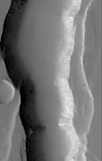
Claritas Fossae is a densely-dissected highland terrain on the Tharsis Rise of Mars, located immediately south of the Tharsis Montes. The fossae of the Claritas Fossae region are many superposed swarms of graben.

The Thaumasia Planum of Mars lies south of Melas Chasmata and Coprates Chasmata. It is in the Coprates quadrangle. Its center is located at 21.66 S and 294.78 E. It was named after a classical albedo feature. The name was approved in 2006. Some forms on its surface are evidence of a flow of lava or water the Melas Chasma. Many wrinkle ridges and grabens are visible. One set of grabens, called Nia Fossae, seem to follow the curve of Melas Chasmata which lies just to the north. Some researchers have discovered dikes in this region. For the study, Thermal Emission Imaging System (THEMIS) daytime infrared images, THEMIS nighttime infrared images, CTX images, and HiRISE images were used. These dikes contain magnesium-rich olivine which indicates a primitive magma composition. Dikes occur when magma follows cracks and faults under the ground. Sometimes erosion reveals them. The presence of pit craters, narrow grabens, linear troughs, and ovoid troughs are also evidence of dikes. These dikes that lie close to and parallel to Valles Marineris, the great canyon system, are evidence that extensional stress aided the formation of Valles Marineris. They may be part of a system of dikes that came from the same magma source that fed the whole area. That source may have been a “plume” of molted rock that rose from the Martian mantle.