Thermal Emission Imaging System

Last updated
The THEMIS instrument, before being mounted onto Mars Odyssey. Themis-lg.jpg
The THEMIS instrument, before being mounted onto Mars Odyssey.

The Thermal Emission Imaging System (THEMIS) is a camera on board the 2001 Mars Odyssey orbiter. It images Mars in the visible and infrared parts of the electromagnetic spectrum in order to determine the thermal properties of the surface and to refine the distribution of minerals on the surface of Mars as determined by the Thermal Emission Spectrometer (TES). Additionally, it helps scientists to understand how the mineralogy of Mars relates to its landforms, and it can be used to search for thermal hotspots in the Martian subsurface.

Contents

THEMIS is managed from the Mars Space Flight Facility at Arizona State University and was built by the Santa Barbara Remote Sensing division of Raytheon Technologies Corporation, an American multinational conglomerate headquartered in Waltham, Massachusetts. The instrument is named after Themis, the goddess of justice in ancient Greek mythology.

Infrared camera

Spatial resolution comparison between MGS's TES instrument and Odyssey's THEMIS instrument. (The spectral resolutions are inversely related.) Tesvsthemis-med.jpg
Spatial resolution comparison between MGS's TES instrument and Odyssey's THEMIS instrument. (The spectral resolutions are inversely related.)
Sample map from Terra's ASTER instrument: Saline Valley, California Asterminerals-med.jpg
Sample map from Terra's ASTER instrument: Saline Valley, California
Map showing distribution of hematite in Sinus Meridiani. This data was used to target the landing of the Opportunity rover. Hematite is usually formed in the presence of water. Opportunity landed in this area and did find much evidence for water. Hematite region Sinus Meridiani sur Mars.jpg
Map showing distribution of hematite in Sinus Meridiani. This data was used to target the landing of the Opportunity rover. Hematite is usually formed in the presence of water. Opportunity landed in this area and did find much evidence for water.

THEMIS detects thermal infrared energy emitted by the Martian surface at nine different wavelengths. Eight of these have wavelengths between 6 and 13 micrometers, an ideal region of the infrared spectrum to determine thermal energy patterns characteristic of silicate minerals. The ninth band is at 14.9 micrometers and is used to monitor the Martian atmosphere. The shortest infrared wavelength, at 6.78 micrometers, is measured twice in two bands to improve the signal-to-noise ratio. THEMIS is therefore a 10-band instrument that detects nine different wavelengths .

The absorption spectrum measured by THEMIS contains two kinds of information: temperature and emissivity. The temperature contribution to the measurement dominates the spectrum unless the data is corrected. In effect, a THEMIS infrared image taken during the day will look much like a shaded relief map, with slopes facing the sun being bright (hot) and shaded areas being dark (cold). In a THEMIS image taken at night, however, thermophysical properties of the surface can be inferred, such as temperature differences due to the materials' grain size (thermal inertia).

The effect of temperature can be removed from THEMIS infrared data by dividing the image by a black body curve. The resulting energy pattern is an emissivity spectrum characteristic of the specific minerals (or other things) found on the surface. The presence of minerals such as carbonates, silicates, hydroxides, sulfates, amorphous silica, oxides, and phosphates can be determined from THEMIS measurements.

In particular, this multi-spectral method allows researchers to detect the presence of minerals that form in water and to understand those minerals in their geological context.

The THEMIS infrared camera was designed to be used in conjunction with data from the Thermal Emission Spectrometer (TES), a similar instrument on Mars Global Surveyor. While THEMIS has a very high spatial resolution (100 m) with a low spectral resolution of only 10 bands between 6 and 15 micrometers, TES has a low spatial resolution (3×6 km) with very high spectral resolution of 143 bands between 5 and 50 micrometers.

The instrument's approach provides data on localized deposits associated with volcanoes, hydrothermal processes, and the alteration of minerals by surface and/or subsurface water.

The Advanced Spaceborne Thermal Emission and Reflection Radiometer (ASTER), an Earth orbiting instrument on the Terra spacecraft, has used a similar approach to map the distribution of minerals on Earth. Variations in the thermal infrared false-color image are due to differences in the minerals that make up rocks and soil.

Discovery of a variety of rocks

THEMIS found a wide range of igneous rocks and minerals. Some of the rocks were low-silica basalts, high silica dacite, olivine basalts, ultramafic (picritic) basalts, and quartz-bearing granitoid rocks. The olivine basalts were present in a variety of locations, such as on crater floors and in some canyon wall layers. The mineral olivine is important because it is common in more primitive magmas from the mantle and it weathers quickly when moisture is present. So, if olivine is present, the climate must have been dry since the time that olivine was exposed. Quartz-bearing rocks were found in the central uplifts in craters. Rocks in the central uplifts[ clarification needed ] were probably once buried several kilometers beneath the surface, but raised by the impact process. Rocks of dacite composition show that, within magma chambers, fractional crystallization occurred. [1] In this process, some minerals form crystals, then settle to the bottom of the chamber. Having a variety of rocks increases the chances that some useful/valuable minerals may be found on Mars.

Visible camera

THEMIS has a visible imaging camera that acquires data in five spectral bands, takes images with a spatial resolution of 18 m (59'), and can resolve objects about the size of a semi-trailer. This resolution is intermediate between large-scale images from the Viking Orbiters (150 to 300 meters per pixel) and the high-resolution images from the Mars Orbiter Camera (MOC) on board Mars Global Surveyor (1.5 to 3 meters per pixel). Visible images from THEMIS are usually close to 20 km wide (12 miles). [2]

The THEMIS visible camera's stated purpose is to determine the geological record of past liquid and volcanic environments on Mars. Additionally, this dataset can be used in conjunction with the infrared data to identify potential landing sites for future Mars missions.

Mars - horizon views (video; 1:24; Odyssey orbiter; THEMIS camera; 9 May 2023)

Images from the Oxia Palus quadrangle

Images from Coprates quadrangle

Images from Lunae Palus quadrangle

Images from Margaritifer Sinus quadrangle

Images from Phoenicis Lacus quadrangle

Images from Hellas quadrangle

Images from Memnonia quadrangle

Other Images from THEMIS

Bopolu crater

Specifications

The Thermal Emission Imaging System weighs 11.2 kilograms (24.7 lb), is 54.5 x 37 x 28.6 cm (21.5 x 14.6 x 11.3 in) and runs on 14 watts of electrical power.

See also

Related Research Articles

Vallis or valles is the Latin word for valley. It is used in planetary geology to name landform features on other planets.

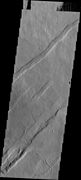
In planetary nomenclature, a fossa is a long, narrow depression (trough) on the surface of an extraterrestrial body, such as a planet or moon. The term, which means "ditch" or "trench" in Latin, is not a geological term as such but a descriptor term used by the United States Geological Survey (USGS) and the International Astronomical Union (IAU) for topographic features whose geology or geomorphology is uncertain due to lack of data or knowledge of the exact processes that formed them. Fossae are believed to be the result of a number of geological processes, such as faulting or subsidence. Many fossae on Mars are probably graben.

<span class="mw-page-title-main">Memnonia quadrangle</span> Map of Mars

The Memnonia quadrangle is one of a series of 30 quadrangle maps of Mars used by the United States Geological Survey (USGS) Astrogeology Research Program. The Memnonia quadrangle is also referred to as MC-16.

<span class="mw-page-title-main">Aram Chaos</span> Crater on Mars

Aram Chaos, centered at 2.6°N, 21.5°W, is a heavily eroded impact crater on Mars. It lies at the eastern end of the large canyon Valles Marineris and close to Ares Vallis. Various geological processes have reduced it to a circular area of chaotic terrain. Aram Chaos takes its name from Aram, one of the classical albedo features observed by Giovanni Schiaparelli, who named it after the Biblical land of Aram. Spectroscopic observation from orbit indicates the presence of the mineral hematite, likely a signature of a once aqueous environment.

In planetary nomenclature, a chasma is a deep, elongated, steep-sided depression. As of 2020, the IAU has named 122 such features in the Solar System, on Venus (63), Mars (25), Saturn's satellites Mimas (6), Tethys (2), Dione (8) and Rhea (5), Uranus's satellites Ariel (7), Titania (2) and Oberon (1) and Pluto's satellite Charon (3). An example is Eos Chasma on Mars.

<span class="mw-page-title-main">Syrtis Major quadrangle</span> One of a series of 30 quadrangle maps of Mars

The Syrtis Major quadrangle is one of a series of 30 quadrangle maps of Mars used by the United States Geological Survey (USGS) Astrogeology Research Program. The Syrtis Major quadrangle is also referred to as MC-13.

<span class="mw-page-title-main">Amenthes quadrangle</span> Map of Mars

The Amenthes quadrangle is one of a series of 30 quadrangle maps of Mars used by the United States Geological Survey (USGS) Astrogeology Research Program. The Amenthes quadrangle is also referred to as MC-14. The quadrangle covers the area from 225° to 270° west longitude and from 0° to 30° north latitude on Mars. Amenthes quadrangle contains parts of Utopia Planitia, Isidis Planitia, Terra Cimmeria, and Tyrrhena Terra.

<span class="mw-page-title-main">Elysium quadrangle</span> One of 30 quadrangle maps of Mars used by the US Geological Survey

The Elysium quadrangle is one of a series of 30 quadrangle maps of Mars used by the United States Geological Survey (USGS) Astrogeology Research Program. The Elysium quadrangle is also referred to as MC-15.

<span class="mw-page-title-main">Amazonis quadrangle</span> Map of Mars

The Amazonis quadrangle is one of a series of 30 quadrangle maps of Mars used by the United States Geological Survey (USGS) Astrogeology Research Program. The Amazonis quadrangle is also referred to as MC-8.

<span class="mw-page-title-main">Tharsis quadrangle</span> Map of Mars

The Tharsis quadrangle is one of a series of 30 quadrangle maps of Mars used by the United States Geological Survey (USGS) Astrogeology Research Program. The Tharsis quadrangle is also referred to as MC-9 . The name Tharsis refers to a land mentioned in the Bible. It may be at the location of the old town of Tartessus at the mouth of Guadalquivir.

<span class="mw-page-title-main">Lunae Palus quadrangle</span> Quadrangle map of Mars

The Lunae Palus quadrangle is one of a series of 30 quadrangle maps of Mars used by the United States Geological Survey (USGS) Astrogeology Research Program. The quadrangle is also referred to as MC-10. Lunae Planum and parts of Xanthe Terra and Chryse Planitia are found in the Lunae Palus quadrangle. The Lunae Palus quadrangle contains many ancient river valleys.

<span class="mw-page-title-main">Oxia Palus quadrangle</span> Map of Mars

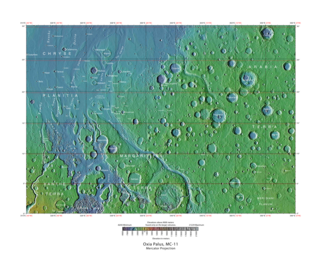
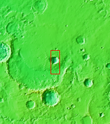
The Oxia Palus quadrangle is one of a series of 30 quadrangle maps of Mars used by the United States Geological Survey (USGS) Astrogeology Research Program. The Oxia Palus quadrangle is also referred to as MC-11.

<span class="mw-page-title-main">Iapygia quadrangle</span> Map of Mars

The Iapygia quadrangle is one of a series of 30 quadrangle maps of Mars used by the United States Geological Survey (USGS) Astrogeology Research Program. The Iapygia quadrangle is also referred to as MC-21. It was named after the heel of the boot of Italy. That name was given by the Greeks It is part of a region of Italy named Apulia. The name Iapygia was approved in 1958.

<span class="mw-page-title-main">Mare Tyrrhenum quadrangle</span> Part of the surface of Mars

The Mare Tyrrhenum quadrangle is one of a series of 30 quadrangle maps of Mars used by the United States Geological Survey (USGS) Astrogeology Research Program. This quadrangle is also referred to as MC-22. It contains parts of the regions Tyrrhena Terra, Hesperia Planum, and Terra Cimmeria.

<span class="mw-page-title-main">Phoenicis Lacus quadrangle</span> Map of Mars

The Phoenicis Lacus quadrangle is one of a series of 30 quadrangle maps of Mars used by the United States Geological Survey (USGS) Astrogeology Research Program. The Phoenicis Lacus quadrangle is also referred to as MC-17. Parts of Daedalia Planum, Sinai Planum, and Solis Planum are found in this quadrangle. Phoenicis Lacus is named after the phoenix which according to myth burns itself up every 500 years and then is reborn.

<span class="mw-page-title-main">Coprates quadrangle</span> Map of Mars

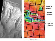
The Coprates quadrangle is one of a series of 30 quadrangle maps of Mars used by the United States Geological Survey (USGS) Astrogeology Research Program. The Coprates quadrangle is also referred to as MC-18. The Coprates quadrangle contains parts of many of the old classical regions of Mars: Sinai Planum, Solis Planum, Thaumasia Planum, Lunae Planum, Noachis Terra, and Xanthe Terra.

<span class="mw-page-title-main">Margaritifer Sinus quadrangle</span> One of a series of 30 quadrangle maps of Mars

The Margaritifer Sinus quadrangle is one of a series of 30 quadrangle maps of Mars used by the United States Geological Survey (USGS) Astrogeology Research Program. The Margaritifer Sinus quadrangle is also referred to as MC-19. The Margaritifer Sinus quadrangle covers the area from 0° to 45° west longitude and 0° to 30° south latitude on Mars. Margaritifer Sinus quadrangle contains Margaritifer Terra and parts of Xanthe Terra, Noachis Terra, Arabia Terra, and Meridiani Planum.

To date, interplanetary spacecraft have provided abundant evidence of water on Mars, dating back to the Mariner 9 mission, which arrived at Mars in 1971. This article provides a mission by mission breakdown of the discoveries they have made. For a more comprehensive description of evidence for water on Mars today, and the history of water on that planet, see Water on Mars.

The Mars orbiter 2001 Mars Odyssey found much evidence for water on Mars in the form of pictures, and with a spectrometer it proved that much of the ground is loaded with ice.

<span class="mw-page-title-main">Thaumasia Planum</span> Planum on Mars

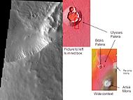
The Thaumasia Planum of Mars lies south of Melas Chasmata and Coprates Chasmata. It is in the Coprates quadrangle. Its center is located at 21.66 S and 294.78 E. It was named after a classical albedo feature. The name was approved in 2006. Some forms on its surface are evidence of a flow of lava or water the Melas Chasma. Many wrinkle ridges and grabens are visible. One set of grabens, called Nia Fossae, seem to follow the curve of Melas Chasmata which lies just to the north.

References

  1. Christensen, P. et al. 2005. Evidence for magmatic evolution and diversity on Mars from infrared observations. Nature: 436. 504–509.
  2. "Mars Odyssey: Technology". Archived from the original on 2009-01-25. Retrieved 2009-02-21.