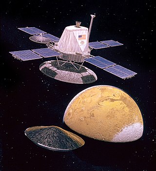
Coordinates | 15°00′N67°30′W / 15°N 67.5°W |
---|
The Lunae Palus quadrangle is one of a series of 30 quadrangle maps of Mars used by the United States Geological Survey (USGS) Astrogeology Research Program. The quadrangle is also referred to as MC-10 (Mars Chart-10). [1] Lunae Planum and parts of Xanthe Terra and Chryse Planitia are found in the Lunae Palus quadrangle. The Lunae Palus quadrangle contains many ancient river valleys.
The quadrangle covers the area from 45° to 90° west longitude and 0° to 30° north latitude on Mars. The Viking 1 Lander (part of Viking program) landed in the quadrangle on July 20, 1976, at 22°24′N47°30′W / 22.4°N 47.5°W . It was the first robot spacecraft to successfully land on the Red Planet. [2]
The sky would be a light pink. The dirt would also appear pink. Rocks of many sizes would be spread about. One large rock, named Big Joe, is as big as a banquet table. Some boulders would show erosion due to the wind. [3] There would be many small sand dunes that are still active. The wind speed would typically be 7 meters per second (16 miles per hour). There would be a hard crust on the top of the soil similar to a deposit, called caliche which is common in the U.S. Southwest. [4] [5] Such crusts are formed by solutions of minerals moving up through soil and evaporating at the surface. [6]
The soil resembled those produced from the weathering of basaltic lavas. The tested soil contained abundant silicon and iron, along with significant amounts of magnesium, aluminum, sulfur, calcium, and titanium. Trace elements, strontium and yttrium, were detected. The amount of potassium was five times lower than the average for the Earth's crust. Some chemicals in the soil contained sulfur and chlorine that were like those remaining after the evaporation of sea water. Sulfur was more concentrated in the crust on top of the soil than in the bulk soil beneath. The sulfur may be present as sulfates of sodium, magnesium, calcium, or iron. A sulfide of iron is also possible. [7] Both the Spirit rover and the Opportunity rover also found sulfates on Mars; consequently sulfates may be common on the Martian surface. [8] The Opportunity rover (landed in 2004 with advanced instruments) found magnesium sulfate and calcium sulfate at Meridiani Planum. [9] Using results from the chemical measurements, mineral models suggest that the soil could be a mixture of about 80% iron-rich clay, about 10% magnesium sulfate (kieserite?), about 5% carbonate (calcite), and about 5% iron oxides (hematite, magnetite, goethite?). These minerals are typical weathering products of mafic igneous rocks. [10] Studies with magnets aboard the landers indicated that the soil is 3–7% magnetic materials by weight. The magnetic chemicals could be magnetite and maghemite. These could come from the weathering of basalt rock. [11] [12] Experiments carried out by the Mars Spirit rover (landed in 2004) indicated that magnetite could explain the magnetic nature of the dust and soil on Mars. Magnetite was found in the soil and that the most magnetic part of the soil was dark. Magnetite is very dark. [13]
Viking did three experiments looking for life. The results were surprising and interesting. Most scientists now believe that the data were due to inorganic chemical reactions of the soil. But a few still believe the results were due to living reactions. No organic chemicals were found in the soil; hence nearly all the scientific community thought that no life was found because no organic chemicals were detected. Not finding any organics was unusual since meteorites raining on Mars for 5 billion years or so would surely bring some organics. Moreover, dry areas of Antarctica do not have detectable organic compounds either, but they have organisms living in the rocks. [14] Mars has almost no ozone layer, unlike the Earth, so UV light sterilizes the surface and produces highly reactive chemicals such as peroxides that would oxidize any organic chemicals. [15] Perchlorate may be the oxidizing chemical. The Phoenix lander discovered the chemical perchlorate in the Martian Soil. Perchlorate is a strong oxidant so it may have destroyed any organic matter on the surface. [16] If it is widespread on Mars, carbon-based life would be difficult at the soil surface.
The question of life on Mars received a new, important twist when research, published in the Journal of Geophysical Research in September 2010, proposed that organic compounds were actually present in the soil analyzed by both Viking 1 and 2. NASA's Phoenix lander in 2008 detected perchlorate which can break down organic compounds. The study's authors found that perchlorate will destroy organics when heated and will produce chloromethane and dichloromethane, the identical chlorine compounds discovered by both Viking landers when they performed the same tests on Mars. Because perchlorate would have broken down any Martian organics, the question of whether or not Viking found life is still wide open. [17]
"Vallis" (plural "valles") is the Latin word for valley. It is used in planetary geology for the naming of landform features on other planets.
"Vallis" was used for old river valleys that were discovered on Mars, when we probes were first sent to Mars. The Viking Orbiters caused a revolution in our ideas about water on Mars; huge river valleys were found in many areas. Orbiting cameras showed that floods of water broke through dams, carved deep valleys, eroded grooves into bedrock, and traveled thousands of kilometers. [18] [19] [20]
The Viking Orbiters caused a revolution in our ideas about water on Mars. Huge river valleys were found in many areas. They showed that floods of water broke through dams, carved deep valleys, eroded grooves into bedrock, and traveled thousands of kilometers. [18] [19] [20]
Hypanis Vallis, in the Lunae Palus quadrangle, was one of the sites proposed as a landing site for the Mars Science Laboratory, popularly known as the Mars Curiosity rover. One aim of the Mars Science Laboratory is to search for signs of ancient life, as many Martian rocks occur in a context of hydrogeology, that is, they were formed in water, at the bottom of lakes or seas, or by water percolating through the soil, although Brown University researchers have recently suggested outgassing of steam to atmosphere from a new planet's interior can also produce the clay minerals seen in these rocks. [21]
Because such issues remain unresolved, it is hoped that a later mission could return samples from sites identified as offering best chances for remains of life. To bring the craft down safely, a 12-mile wide, smooth, flat circle was needed. Geologists hoped to examine places where water once ponded, [22] and to examine its sediment layers. The site eventually settled on for the Mars Science Laboratory was Gale Crater in the Aeolis quadrangle, and a successful landing took place there in 2012. The rover is still operational as of early 2019. NASA scientists believe Gale Crater's floor rocks are indeed sedimentary, formed in pooled water. [23]
One of the most significant features of the Lunae Palus region, Kasei Valles, is one of the largest outflow channels on Mars. Like other outflow channels, it was carved by liquid water, probably during gigantic floods.
Kasei is about 2,400 kilometers (1,500 mi) long. Some sections of Kasei Valles are 300 kilometers (190 mi) wide. It begins in Echus Chasma, near Valles Marineris, and empties into Chryse Planitia, not far from where Viking 1 landed. Sacra Mensa, a large tableland, divides Kasei into northern and southern channels. It is one of the longest continuous outflow channels on Mars. At around 20° north latitude Kasei Valles splits into two channels, called Kasei Vallis Canyon and North Kasei Channel. These branches recombine at around 63° west longitude. Some parts of Kasei Valles are 2–3 km deep. [24]
Scientists suggest it was formed several episodes of flooding and maybe by some glacial activity. [25]
Researchers have found a number of examples of deltas that formed in Martian lakes. Finding deltas is a major sign that Mars once had a lot of water. Deltas often require deep water over a long period of time to form. Also, the water level needs to be stable to keep sediment from washing away. Deltas have been found over a wide geographical range. [26]
Impact craters generally have a rim with ejecta around them, in contrast volcanic craters usually do not have a rim or ejecta deposits. As craters get larger (greater than 10 km in diameter) they usually have a central peak. [27] The peak is caused by a rebound of the crater floor following the impact. [18] Sometimes craters will display layers. Craters can show us what lies deep under the surface.
Large troughs (long narrow depressions) are called fossae in the geographical language used for Mars. This term is derived from Latin; therefore fossa is singular and fossae is plural. [28] Troughs form when the crust is stretched until it breaks. The stretching can be due to the large weight of a nearby volcano. Fossae/pit craters are common near volcanoes in the Tharsis and Elysium system of volcanoes. [29]
The Viking 2 mission was part of the American Viking program to Mars, and consisted of an orbiter and a lander essentially identical to that of the Viking 1 mission. Viking 2 was operational on Mars for 1281 sols. The Viking 2 lander operated on the surface for 1,316 days, or 1281 sols, and was turned off on April 12, 1980, when its batteries failed. The orbiter worked until July 25, 1978, returning almost 16,000 images in 706 orbits around Mars.
Vallis or valles is the Latin word for valley. It is used in planetary geology to name landform features on other planets.
The Thermal Emission Imaging System (THEMIS) is a camera on board the 2001 Mars Odyssey orbiter. It images Mars in the visible and infrared parts of the electromagnetic spectrum in order to determine the thermal properties of the surface and to refine the distribution of minerals on the surface of Mars as determined by the Thermal Emission Spectrometer (TES). Additionally, it helps scientists to understand how the mineralogy of Mars relates to its landforms, and it can be used to search for thermal hotspots in the Martian subsurface.
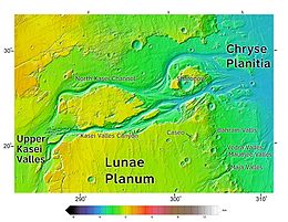
Chryse Planitia is a smooth circular plain in the northern equatorial region of Mars close to the Tharsis region to the west, centered at 28.4°N 319.7°E. Chryse Planitia lies partially in the Lunae Palus quadrangle, partially in the Oxia Palus quadrangle, partially in the Mare Acidalium quadrangle. It is 1600 km or 994 mi in diameter and with a floor 2.5 km below the average planetary surface altitude, and has been suggested to be an ancient buried impact basin, though this is contested. It has several features in common with lunar maria, such as wrinkle ridges. The density of impact craters in the 100 to 2,000 metres range is close to half the average for lunar maria.
The Memnonia quadrangle is one of a series of 30 quadrangle maps of Mars used by the United States Geological Survey (USGS) Astrogeology Research Program. The Memnonia quadrangle is also referred to as MC-16.
Xanthe Terra is a large area on Mars, centered just north of the Martian equator. Its coordinates are 3°N312°E and its diameter is 1867.65 km. Its name means "golden-yellow land." It is in the Lunae Palus quadrangle, the Coprates quadrangle, the Margaritifer Sinus quadrangle, and the Oxia Palus quadrangle.
The Cebrenia quadrangle is one of a series of 30 quadrangle maps of Mars used by the United States Geological Survey (USGS) Astrogeology Research Program. The quadrangle is located in the northeastern portion of Mars' eastern hemisphere and covers 120° to 180° east longitude and 30° to 65° north latitude. The quadrangle uses a Lambert conformal conic projection at a nominal scale of 1:5,000,000 (1:5M). The Cebrenia quadrangle is also referred to as MC-7. It includes part of Utopia Planitia and Arcadia Planitia. The southern and northern borders of the Cebrenia quadrangle are approximately 3,065 km (1,905 mi) and 1,500 km (930 mi) wide, respectively. The north to south distance is about 2,050 km (1,270 mi). The quadrangle covers an approximate area of 4.9 million square km, or a little over 3% of Mars' surface area.
The Amenthes quadrangle is one of a series of 30 quadrangle maps of Mars used by the United States Geological Survey (USGS) Astrogeology Research Program. The Amenthes quadrangle is also referred to as MC-14. The quadrangle covers the area from 225° to 270° west longitude and from 0° to 30° north latitude on Mars. Amenthes quadrangle contains parts of Utopia Planitia, Isidis Planitia, Terra Cimmeria, and Tyrrhena Terra.
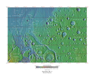
The Oxia Palus quadrangle is one of a series of 30 quadrangle maps of Mars used by the United States Geological Survey (USGS) Astrogeology Research Program. The Oxia Palus quadrangle is also referred to as MC-11.
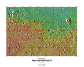
The Iapygia quadrangle is one of a series of 30 quadrangle maps of Mars used by the United States Geological Survey (USGS) Astrogeology Research Program. The Iapygia quadrangle is also referred to as MC-21. It was named after the heel of the boot of Italy. That name was given by the Greeks It is part of a region of Italy named Apulia. The name Iapygia was approved in 1958.
The Mare Tyrrhenum quadrangle is one of a series of 30 quadrangle maps of Mars used by the United States Geological Survey (USGS) Astrogeology Research Program. This quadrangle is also referred to as MC-22. It contains parts of the regions Tyrrhena Terra, Hesperia Planum, and Terra Cimmeria.
The Phoenicis Lacus quadrangle is one of a series of 30 quadrangle maps of Mars used by the United States Geological Survey (USGS) Astrogeology Research Program. The Phoenicis Lacus quadrangle is also referred to as MC-17. Parts of Daedalia Planum, Sinai Planum, and Solis Planum are found in this quadrangle. Phoenicis Lacus is named after the phoenix which according to myth burns itself up every 500 years and then is reborn.
The Coprates quadrangle is one of a series of 30 quadrangle maps of Mars used by the United States Geological Survey (USGS) Astrogeology Research Program. The Coprates quadrangle is also referred to as MC-18. The Coprates quadrangle contains parts of many of the old classical regions of Mars: Sinai Planum, Solis Planum, Thaumasia Planum, Lunae Planum, Noachis Terra, and Xanthe Terra.
The Margaritifer Sinus quadrangle is one of a series of 30 quadrangle maps of Mars used by the United States Geological Survey (USGS) Astrogeology Research Program. The Margaritifer Sinus quadrangle is also referred to as MC-19. The Margaritifer Sinus quadrangle covers the area from 0° to 45° west longitude and 0° to 30° south latitude on Mars. Margaritifer Sinus quadrangle contains Margaritifer Terra and parts of Xanthe Terra, Noachis Terra, Arabia Terra, and Meridiani Planum.
The Thaumasia quadrangle is one of a series of 30 quadrangle maps of Mars used by the United States Geological Survey (USGS) Astrogeology Research Program. The Thaumasia quadrangle is also referred to as MC-25 . The name comes from Thaumas, the god of the clouds and celestial apparitions.
The Maja Valles are a large system of ancient outflow channels in the Lunae Palus quadrangle on Mars. Their location is 12.6° north latitude and 58.3° west longitude. The name is a Nepali word for "Mars". The Maja Valles begin at Juventae Chasma. Parts of the system have been partially buried by thin volcanic debris. The channels end at Chryse Planitia.
Bahram Vallis is an ancient river valley in the Lunae Palus quadrangle of Mars at 20.7° north latitude and 57.5° west longitude. It is about 302 km long and was named after the word for 'Mars' in Persian. Bahram Vallis is located midway between Vedra Valles and lower Kasei Valles. It is basically a single trunk valley, with scalloped walls in some places. The presence of streamlined erosional features on its floor shows that fluid was involved with its formation.
The Kasei Valles are a giant system of canyons in Mare Acidalium and Lunae Palus quadrangles on Mars, centered at 24.6° north latitude and 65.0° west longitude. They are 1,580 km (980 mi) long and were named for the word for "Mars" in Japanese. This is one of the largest outflow channel systems on Mars.
The Nanedi Valles are a set of channels in a large valley in the Lunae Palus quadrangle of Mars, located at 4.9° N and 49.0° W. They are 508 km long and were named for the word for "planet" in Sesotho, the national language of Lesotho, Africa.
To date, interplanetary spacecraft have provided abundant evidence of water on Mars, dating back to the Mariner 9 mission, which arrived at Mars in 1971. This article provides a mission by mission breakdown of the discoveries they have made. For a more comprehensive description of evidence for water on Mars today, and the history of water on that planet, see Water on Mars.