
Tharsis is a vast volcanic plateau centered near the equator in the western hemisphere of Mars. The region is home to the largest volcanoes in the Solar System, including the three enormous shield volcanoes Arsia Mons, Pavonis Mons, and Ascraeus Mons, which are collectively known as the Tharsis Montes. The tallest volcano on the planet, Olympus Mons, is often associated with the Tharsis region but is actually located off the western edge of the plateau. The name Tharsis is the Greco-Latin transliteration of the biblical Tarshish, the land at the western extremity of the known world.

Ascraeus Mons is a large shield volcano located in the Tharsis region of the planet Mars. It is the northernmost and tallest of three shield volcanoes collectively known as the Tharsis Montes.

Elysium, located in the Elysium and Cebrenia quadrangles, is the second largest volcanic region on Mars, after Tharsis. The region includes the volcanoes Hecates Tholus, Elysium Mons and Albor Tholus. The province is centered roughly on Elysium Mons at 24.7°N 150°E. Elysium Planitia is a broad plain to the south of Elysium, centered at 3.0°N 154.7°E. Another large volcano, Apollinaris Mons, lies south of Elysium Planitia and is not part of the province. Besides having large volcanoes, Elysium has several areas with long trenches, called fossa or fossae (plural) on Mars. They include the Cerberus Fossae, Elysium Fossae, Galaxias Fossae, Hephaestus Fossae, Hyblaeus Fossae, Stygis Fossae and Zephyrus Fossae.

Terra Cimmeria is a large Martian region, centered at 34.7°S 145°E and covering 5,400 km (3,400 mi) at its broadest extent. It covers latitudes 15 N to 75 S and longitudes 170 to 260 W. It lies in the Eridania quadrangle. Terra Cimmeria is one part of the heavily cratered, southern highland region of the planet. The Spirit rover landed near the area.

Acidalia Planitia is a plain on Mars, between the Tharsis volcanic province and Arabia Terra to the north of Valles Marineris, centered at 49.8°N 339.3°E. Most of this region is found in the Mare Acidalium quadrangle, but a small part is in the Ismenius Lacus quadrangle. The plain contains the famous Cydonia region at the contact with the heavily cratered highland terrain.

The geology of Mars is the scientific study of the surface, crust, and interior of the planet Mars. It emphasizes the composition, structure, history, and physical processes that shape the planet. It is analogous to the field of terrestrial geology. In planetary science, the term geology is used in its broadest sense to mean the study of the solid parts of planets and moons. The term incorporates aspects of geophysics, geochemistry, mineralogy, geodesy, and cartography. A neologism, areology, from the Greek word Arēs (Mars), sometimes appears as a synonym for Mars's geology in the popular media and works of science fiction. The term areology is also used by the Areological Society.

The climate of Mars has been a topic of scientific curiosity for centuries, in part because it is the only terrestrial planet whose surface can be directly observed in detail from the Earth with help from a telescope.
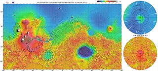
The most conspicuous feature of Mars is a sharp contrast, known as the Martian dichotomy, between the Southern and the Northern hemispheres. The two hemispheres' geography differ in elevation by 1 to 3 km. The average thickness of the Martian crust is 45 km, with 32 km in the northern lowlands region, and 58 km in the southern highlands.
Volcanic activity, or volcanism, has played a significant role in the geologic evolution of Mars. Scientists have known since the Mariner 9 mission in 1972 that volcanic features cover large portions of the Martian surface. These features include extensive lava flows, vast lava plains, and the largest known volcanoes in the Solar System. Martian volcanic features range in age from Noachian to late Amazonian, indicating that the planet has been volcanically active throughout its history, and some speculate it probably still is so today. Both Earth and Mars are large, differentiated planets built from similar chondritic materials. Many of the same magmatic processes that occur on Earth also occurred on Mars, and both planets are similar enough compositionally that the same names can be applied to their igneous rocks and minerals.

The Mars ocean hypothesis states that nearly a third of the surface of Mars was covered by an ocean of liquid water early in the planet's geologic history. This primordial ocean, dubbed Paleo-Ocean and Oceanus Borealis, would have filled the basin Vastitas Borealis in the northern hemisphere, a region which lies 4–5 km below the mean planetary elevation, at a time period of approximately 4.1–3.8 billion years ago. Evidence for this ocean includes geographic features resembling ancient shorelines, and the chemical properties of the Martian soil and atmosphere. Early Mars would have required a denser atmosphere and warmer climate to allow liquid water to remain at the surface.
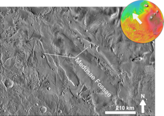
The Medusae Fossae Formation is a large geological formation of probable volcanic origin on the planet Mars. It is named for the Medusa of Greek mythology. "Fossae" is Latin for "trenches". The formation is a collection of soft, easily eroded deposits that extends discontinuously for more than 5,000 km along the equator of Mars. Its roughly-shaped regions extend from just south of Olympus Mons to Apollinaris Patera, with a smaller additional region closer to Gale Crater.

The Arcadia quadrangle is one of a series of 30 quadrangle maps of Mars used by the United States Geological Survey (USGS) Astrogeology Research Program. The quadrangle is located in the north-central portion of Mars’ western hemisphere and covers 240° to 300° east longitude and 30° to 65° north latitude. The quadrangle uses a Lambert conformal conic projection at a nominal scale of 1:5,000,000 (1:5M). The Arcadia quadrangle is also referred to as MC-3.

The Mare Acidalium quadrangle is one of a series of 30 quadrangle maps of Mars used by the United States Geological Survey (USGS) Astrogeology Research Program. The quadrangle is located in the northeastern portion of Mars’ western hemisphere and covers 300° to 360° east longitude and 30° to 65° north latitude. The quadrangle uses a Lambert conformal conic projection at a nominal scale of 1:5,000,000 (1:5M). The Mare Acidalium quadrangle is also referred to as MC-4.

The Tharsis quadrangle is one of a series of 30 quadrangle maps of Mars used by the United States Geological Survey (USGS) Astrogeology Research Program. The Tharsis quadrangle is also referred to as MC-9 . The name Tharsis refers to a land mentioned in the Bible. It may be at the location of the old town of Tartessus at the mouth of Guadalquivir.
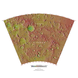
The Phaethontis quadrangle is one of a series of 30 quadrangle maps of Mars used by the United States Geological Survey (USGS) Astrogeology Research Program. The Phaethontis quadrangle is also referred to as MC-24.

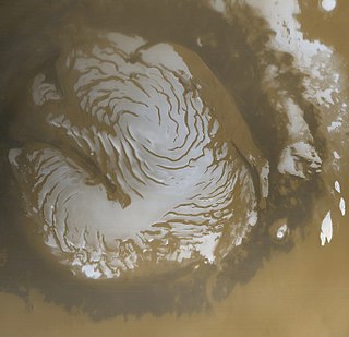
The Mare Australe quadrangle is one of a series of 30 quadrangle maps of Mars used by the United States Geological Survey (USGS) Astrogeology Research Program. The Mare Australe quadrangle is also referred to as MC-30. The quadrangle covers all the area of Mars south of 65°, including the South polar ice cap, and its surrounding area. The quadrangle's name derives from an older name for a feature that is now called Planum Australe, a large plain surrounding the polar cap. The Mars polar lander crash landed in this region.

Nilosyrtis Mensae is an area of Mars in the Casius quadrangle. It is centered on the coordinates of 36.87° N and 67.9° E. Its western and eastern longitudes are 51.1° E and 74.4° E. North and south latitudes are 36.87° N and 29.61° N. Nilosyrtis Mensae is just to the east of Protonilus Mensae and both lie along the Martian dichotomy boundary. Its name was adapted by the IAU in 1973. It was named after a classical albedo feature, and it is 705 km (438 mi) across.
The planet Mars has two permanent polar ice caps. During a pole's winter, it lies in continuous darkness, chilling the surface and causing the deposition of 25–30% of the atmosphere into slabs of CO2 ice (dry ice). When the poles are again exposed to sunlight, the frozen CO2 sublimes. These seasonal actions transport large amounts of dust and water vapor, giving rise to Earth-like frost and large cirrus clouds.

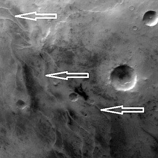
Glaciers, loosely defined as patches of currently or recently flowing ice, are thought to be present across large but restricted areas of the modern Martian surface, and are inferred to have been more widely distributed at times in the past. Lobate convex features on the surface known as viscous flow features and lobate debris aprons, which show the characteristics of non-Newtonian flow, are now almost unanimously regarded as true glaciers.
The Dorsa Argentea Formation (DAF) is thought to be a large system of eskers that were under an ancient ice cap in the south polar region of Mars. The ancient ice cap was at least twice the size of the present ice cap and may have been 1500–2000 meters thick. Later research suggests that the area of this polar ice sheet is believed to have covered about 1.5 million square kilometers, roughly twice the size of France or the American state of Texas. This group of ridges extends from 270–100 E and 70–90 S, around the south pole of Mars. It sits under the Late Amazonian South Polar Layered Deposits (SPLD), in the Mare Australe quadrangle.
