
Swiss cheese features (SCFs) are curious pits in the south polar ice cap of Mars (Mare Australe quadrangle) named from their similarity to the holes in Swiss cheese. They were first seen in 2000 using Mars Orbiter Camera imagery. [1]
Swiss cheese features (SCFs) are curious pits in the south polar ice cap of Mars (Mare Australe quadrangle) named from their similarity to the holes in Swiss cheese. They were first seen in 2000 using Mars Orbiter Camera imagery. [1]
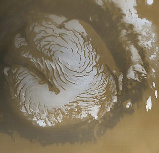
They are typically a few hundred meters across and 8 metres deep, with a flat base and steep sides. They tend to have similar bean-like shapes with a cusp pointing towards the south pole, indicating that insolation is involved in their formation. The angle of the Sun probably contributes to their roundness. Near the Martian summer solstice, the Sun can remain continuously just above the horizon; as a result the walls of a round depression will receive more intense sunlight, and sublimate much more rapidly than the floor. The walls sublimate and recede, while the floor remains the same. [2] [3] As the seasonal frost disappears, the pit walls appear to darken considerably relative to the surrounding terrain. The SCFs have been observed to grow in size, year by year, at an average rate of 1 to 3 meters, suggesting that they are formed in a thin layer (8 m) of carbon dioxide ice lying on top of water ice. [4] [5] Later research with HiRISE showed that the pits are in a 1–10-meter-thick layer of dry ice that is sitting on a much larger water ice cap. Pits have been observed to begin with small areas along faint fractures. The circular pits have steep walls that work to focus sunlight, thereby increasing erosion. For a pit to develop, a steep wall of about 10 cm and a length of over 5 meters is necessary. [6]
Bright transient halo features around the carbon dioxide pits were found during the southern hemisphere's summer, during Mars year 28 (Earth year 2007). However, this was the only time these features have ever been seen. The data to understand these halos were taken from the MRO (Mars Reconnaissance Orbiter) Context Camera, the HiRISE (High Resolution Imaging Science Experiment) camera, and the MOC (Mars Orbiter Camera). The halo features were only visible during the solar longitudes (position of Mars around the Sun) of 279 degrees and 331 degrees. The halo's appearance correlates to the global dust storm that began earlier in the same Martian year. The lifetime of the halos was broken into trimesters; the first was 285–295 degrees Ls (Solar Longitude, time in the Martian Year), the second was 295–305 degrees Ls, and the final was counted at 305–340 degrees Ls. The average width of the high albedo area around the Swiss cheese features changes throughout its lifetime. In the first trimester the width was calculated to be 12.14 ± 1.44 meters wide, the second trimester was 32.96 ± 4.02 meters wide, and in the final trimester the average width was 55.48 ± 6.98 meters. The Hapke's reflectance theory was used to calculate the brightness of the features. [7] During the first trimester, the halos were 4 +/- .3% brighter than the non-halo areas. Then in the second trimester the halos became more prominent at 7 +/- .7% brighter. Toward the end of their life they were the brightest recorded at 8 +/- .6% brighter than the surrounding topography. The halos are brighter than the surrounding region due to the impurities in the ice. The global dust storm filled the CO2 ice with sand and increased the grain size of the ice crystals. [8]


Mars Global Surveyor (MGS) is an American robotic space probe developed by NASA's Jet Propulsion Laboratory and launched November 1996. MGS was a global mapping mission that examined the entire planet, from the ionosphere down through the atmosphere to the surface. As part of the larger Mars Exploration Program, Mars Global Surveyor performed atmospheric monitoring for sister orbiters during aerobraking, and helped Mars rovers and lander missions by identifying potential landing sites and relaying surface telemetry.

Terra Cimmeria is a large Martian region, centered at 34.7°S 145°E and covering 5,400 km (3,400 mi) at its broadest extent. It covers latitudes 15 N to 75 S and longitudes 170 to 260 W. It lies in the Eridania quadrangle. Terra Cimmeria is one part of the heavily cratered, southern highland region of the planet. The Spirit rover landed near the area.

Planum Australe is the southern polar plain on Mars. It extends southward of roughly 75°S and is centered at 83.9°S 160.0°E. The geology of this region was to be explored by the failed NASA mission Mars Polar Lander, which lost contact on entry into the Martian atmosphere.
Deuteronilus Mensae is a region on Mars 937 km across and centered at 43.9°N 337.4°W. It covers 344°–325° West and 40°–48° North. Deuteronilus region lies just to the north of Arabia Terra and is included in the Ismenius Lacus quadrangle. It is along the dichotomy boundary, that is between the old, heavily cratered southern highlands and the low plains of the northern hemisphere. The region contains flat-topped knobby terrain that may have been formed by glaciers at some time in the past. Deuteronilus Mensae is to the immediate west of Protonilus Mensae and Ismeniae Fossae. Glaciers persist in the region in modern times, with at least one glacier estimated to have formed as recently as 100,000 to 10,000 years ago. Recent evidence from the radar on the Mars Reconnaissance Orbiter has shown that parts of Deuteronilus Mensae do indeed contain ice.

Martian geysers are putative sites of small gas and dust eruptions that occur in the south polar region of Mars during the spring thaw. "Dark dune spots" and "spiders" – or araneiforms – are the two most visible types of features ascribed to these eruptions.

The Noachis quadrangle is one of a series of 30 quadrangle maps of Mars used by the United States Geological Survey (USGS) Astrogeology Research Program. The Noachis quadrangle is also referred to as MC-27.

The Arcadia quadrangle is one of a series of 30 quadrangle maps of Mars used by the United States Geological Survey (USGS) Astrogeology Research Program. The quadrangle is located in the north-central portion of Mars’ western hemisphere and covers 240° to 300° east longitude and 30° to 65° north latitude. The quadrangle uses a Lambert conformal conic projection at a nominal scale of 1:5,000,000 (1:5M). The Arcadia quadrangle is also referred to as MC-3.

The Mare Acidalium quadrangle is one of a series of 30 quadrangle maps of Mars used by the United States Geological Survey (USGS) Astrogeology Research Program. The quadrangle is located in the northeastern portion of Mars’ western hemisphere and covers 300° to 360° east longitude and 30° to 65° north latitude. The quadrangle uses a Lambert conformal conic projection at a nominal scale of 1:5,000,000 (1:5M). The Mare Acidalium quadrangle is also referred to as MC-4.

The Hellas quadrangle is one of a series of 30 quadrangle maps of Mars used by the United States Geological Survey (USGS) Astrogeology Research Program. The Hellas quadrangle is also referred to as MC-28 . The Hellas quadrangle covers the area from 240° to 300° west longitude and 30° to 65° south latitude on the planet Mars. Within the Hellas quadrangle lies the classic features Hellas Planitia and Promethei Terra. Many interesting and mysterious features have been discovered in the Hellas quadrangle, including the giant river valleys Dao Vallis, Niger Vallis, Harmakhis, and Reull Vallis—all of which may have contributed water to a lake in the Hellas basin in the distant past. Many places in the Hellas quadrangle show signs of ice in the ground, especially places with glacier-like flow features.

The Eridania quadrangle is one of a series of 30 quadrangle maps of Mars used by the United States Geological Survey (USGS) Astrogeology Research Program. The Eridania quadrangle is also referred to as MC-29.

The Argyre quadrangle is one of a series of 30 quadrangle maps of Mars used by the United States Geological Survey (USGS) Astrogeology Research Program. The Argyre quadrangle is also referred to as MC-26. It contains Argyre Planitia and part of Noachis Terra.

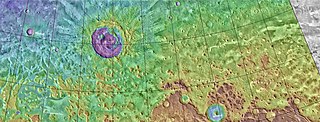
The Mare Australe quadrangle is one of a series of 30 quadrangle maps of Mars used by the United States Geological Survey (USGS) Astrogeology Research Program. The Mare Australe quadrangle is also referred to as MC-30. The quadrangle covers all the area of Mars south of 65°, including the South polar ice cap, and its surrounding area. The quadrangle's name derives from an older name for a feature that is now called Planum Australe, a large plain surrounding the polar cap. The Mars polar lander crash landed in this region.
Fretted terrain is a type of surface feature common to certain areas of Mars and was discovered in Mariner 9 images. It lies between two different types of terrain. The surface of Mars can be divided into two parts: low, young, uncratered plains that cover most of the northern hemisphere, and high-standing, old, heavily cratered areas that cover the southern and a small part of the northern hemisphere. Between these two zones is a region called the Martian dichotomy and parts of it contain fretted terrain. This terrain contains a complicated mix of cliffs, mesas, buttes, and straight-walled and sinuous canyons. It contains smooth, flat lowlands along with steep cliffs. The scarps or cliffs are usually 1 to 2 km high. Channels in the area have wide, flat floors and steep walls. Fretted terrain shows up in northern Arabia, between latitudes 30°N and 50°N and longitudes 270°W and 360°W, and in Aeolis Mensae, between 10 N and 10 S latitude and 240 W and 210 W longitude. Two good examples of fretted terrain are Deuteronilus Mensae and Protonilus Mensae.

McMurdo is a crater in the Mare Australe quadrangle of Mars, located at 84.4° S and 359.1° W. It is 30.3 km in diameter and was named after McMurdo Station in Antarctica.
The planet Mars has two permanent polar ice caps. During a pole's winter, it lies in continuous darkness, chilling the surface and causing the deposition of 25–30% of the atmosphere into slabs of CO2 ice (dry ice). When the poles are again exposed to sunlight, the frozen CO2 sublimes. These seasonal actions transport large amounts of dust and water vapor, giving rise to Earth-like frost and large cirrus clouds.

Martian gullies are small, incised networks of narrow channels and their associated downslope sediment deposits, found on the planet of Mars. They are named for their resemblance to terrestrial gullies. First discovered on images from Mars Global Surveyor, they occur on steep slopes, especially on the walls of craters. Usually, each gully has a dendritic alcove at its head, a fan-shaped apron at its base, and a single thread of incised channel linking the two, giving the whole gully an hourglass shape. They are estimated to be relatively young because they have few, if any craters. A subclass of gullies is also found cut into the faces of sand dunes, that are themselves considered to be quite young. Linear dune gullies are now considered recurrent seasonal features.
The common surface features of Mars include dark slope streaks, dust devil tracks, sand dunes, Medusae Fossae Formation, fretted terrain, layers, gullies, glaciers, scalloped topography, chaos terrain, possible ancient rivers, pedestal craters, brain terrain, and ring mold craters.

South is an impact crater in the Mare Australe quadrangle of Mars, located at 76.9°S latitude and 21.9°E longitude. It measures 101.84 kilometres (63.28 mi) in diameter, and was named after British astronomer Sir James South (1785–1867). The name was approved by the International Astronomical Union (IAU) Working Group for Planetary System Nomenclature in 1973.

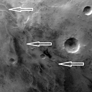
The upper plains unit is the remnants of a 50-100 meter thick mantling that has been discovered in the mid-latitudes of the planet Mars. It was first investigated in the Deuteronilus Mensae region, but it occurs in other places as well. The remnants consist of sets of dipping layers in impact craters, in depressions, and along mesas. Sets of dipping layers may be of various sizes and shapes—some look like Aztec pyramids from Central America.
The Dorsa Argentea Formation (DAF) is thought to be a large system of eskers that were under an ancient ice cap in the south polar region of Mars. The ancient ice cap was at least twice the size of the present ice cap and may have been 1500–2000 meters thick. Later research suggests that the area of this polar ice sheet is believed to have covered about 1.5 million square kilometers, roughly twice the size of France or the American state of Texas. This group of ridges extends from 270–100 E and 70–90 S, around the south pole of Mars. It sits under the Late Amazonian South Polar Layered Deposits (SPLD), in the Mare Australe quadrangle.
| Geography | |||||||||||
|---|---|---|---|---|---|---|---|---|---|---|---|
| Astronomy |
| ||||||||||
| Exploration |
| ||||||||||
| Related | |||||||||||