Mare Boreum quadrangle

Last updated
Mare Boreum quadrangle
USGS-Mars-MC-1-MareBoreumRegion-mola.png
Map of Mare Boreum quadrangle from Mars Orbiter Laser Altimeter (MOLA) data. The highest elevations are red and the lowest are blue.
Coordinates 75°N0°E / 75°N 0°E / 75; 0
Image of the Mare Boreum Quadrangle (MC-1). The region includes the North Polar ice cap, Korolov crater and Chasma Boreale. Mars NPArea-PIA00161.jpg
Image of the Mare Boreum Quadrangle (MC-1). The region includes the North Polar ice cap, Korolov crater and Chasma Boreale.

The Mare Boreum quadrangle is one of a series of 30 quadrangle maps of Mars used by the United States Geological Survey (USGS) Astrogeology Research Program. The Mare Boreum quadrangle is also referred to as MC-1 (Mars Chart-1). [1] Its name derives from an older name for a feature that is now called Planum Boreum, a large plain surrounding the polar cap. [2]

Contents

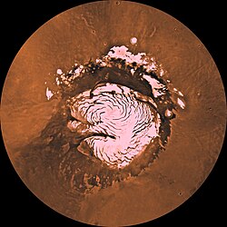
The quadrangle covers all of the Martian surface north of latitude 65°. It includes the north polar ice cap, which has a swirl pattern and is roughly 1,100 kilometres (680 miles) across. Mariner 9 in 1972 discovered a belt of sand dunes that ring the polar ice deposits, which is 500 kilometres (310 miles) across in some places and may be the largest dune field in the Solar System. [3] The ice cap is surrounded by the vast plains of Planum Boreum and Vastitas Borealis. Close to the pole, there is a large valley, Chasma Boreale, that may have been formed from water melting from the ice cap. [4] An alternative view is that it was made by winds coming off the cold pole. [5] [6] Another prominent feature is a smooth rise, formerly called Olympia Planitia. In the summer, a dark collar around the residual cap becomes visible; it is mostly caused by dunes. [7] The quadrangle includes some very large craters that stand out in the north because the area is smooth with little change in topography. These large craters are Lomonosov and Korolev. Although smaller, the crater Stokes is also prominent.

The Phoenix lander landed on Vastitas Borealis within the Mare Boreum quadrangle at 68.218830° N and 234.250778° E on May 25, 2008. [8] The probe collected and analyzed soil samples in an effort to detect water and determine how hospitable the planet might once have been for life to grow. It remained active there until winter conditions became too harsh around five months later. [9]

After the mission ended the journal Science reported that chloride, bicarbonate, magnesium, sodium potassium, calcium, and possibly sulfate were detected in the samples analyzed by Phoenix. The pH was narrowed down to 7.7±0.5. Perchlorate (ClO4), a strong oxidizer at elevated temperatures, was detected. This was a significant discovery because the chemical has the potential of being used for rocket fuel and as a source of oxygen for future colonists. Also, under certain conditions perchlorate can inhibit life; however some microorganisms obtain energy from the substance (by anaerobic reduction). The chemical when mixed with water can greatly lower freezing points, in a manner similar to how salt is applied to roads to melt ice. So, perchlorate may be allowing small amounts of liquid water to form on Mars today. Gullies, which are common in certain areas of Mars, may have formed from perchlorate melting ice and causing water to erode soil on steep slopes. [10]

Much direct evidence was found for water at this location. [11]

Freezing of atmosphere

Research based on slight changes in the orbits of spacecraft around Mars over 16 years found that when one hemisphere experiences winter, approximately 3 trillion to 4 trillion tons of carbon dioxide freezes out of the atmosphere onto the northern and southern polar caps. This represents 12 to 16 percent of the mass of the entire Martian atmosphere. These observation support predictions from the Mars Global Reference Atmospheric Model—2010. [12] [13]

Proof for ocean

Strong evidence for a one time ancient ocean was found in Mare Boreum near the north pole (as well as the south pole). In March 2015, a team of scientists published results showing that this region was highly enriched with deuterium, heavy hydrogen, by seven times as much as the Earth. This means that Mars has lost a volume of water 6.5 times what is stored in today's polar caps. The water for a time would have formed an ocean in the low-lying Mare Boreum. The amount of water could have covered the planet about 140 meters, but was probably in an ocean that in places would be almost 1 mile deep.

This international team used ESO's Very Large Telescope, along with instruments at the W. M. Keck Observatory and the NASA Infrared Telescope Facility, to map out different forms of water in Mars's atmosphere over a six-year period. [14] [15]

Ice cap

From observations with the Shallow Radar instrument (SHARAD) onboard the Mars Reconnaissance Orbiter, researchers determined that the total volume of water ice in the northern ice cap is 821,000 cubic kilometers (197,000 cu mi). That is equal to 30% of the Earth's Greenland ice sheet, or enough to cover the surface of Mars to a depth of 5.6 meters [16] [17] [18]

Ridges

Dunes

Sand dunes have been found in many places on Mars. The presence of dunes shows that the planet has an atmosphere with wind, for dunes require wind to pile up the sand. Most dunes on Mars are black because of the weathering of the volcanic rock basalt. [19] [7] Black sand can be found on Earth on Hawaii and on some tropical South Pacific islands. [20] Sand is common on Mars due to the old age of the surface that has allowed rocks to erode into sand. Dunes on Mars have been observed to move many meters. [21] [22] In this process, sand moves up the windward side and then falls down the leeward side of the dune, thus caused the dune to go toward the leeward side (or slip face). [23] When images are enlarged, some dunes on Mars display ripples on their surfaces. [24] These are caused by sand grains rolling and bouncing up the windward surface of a dune. The bouncing grains tend to land on the windward side of each ripple. The grains do not bounce very high so it does not take much to stop them.

See also

Related Research Articles

<span class="mw-page-title-main">Vastitas Borealis</span> Lowland region in the northern hemisphere of Mars

Vastitas Borealis is the largest lowland region of Mars. It is in the northerly latitudes of the planet and encircles the northern polar region. Vastitas Borealis is often simply referred to as the northern plains, northern lowlands or the North polar erg of Mars. The plains lie 4–5 km below the mean radius of the planet, and is centered at 87.73°N 32.53°E. A small part of Vastitas Borealis reaches below 65°N.

<span class="mw-page-title-main">Terra Cimmeria</span> Terra on Mars

Terra Cimmeria is a large Martian region, centered at 34.7°S 145°E and covering 5,400 km (3,400 mi) at its broadest extent. It covers latitudes 15 N to 75 S and longitudes 170 to 260 W. It lies in the Eridania quadrangle. Terra Cimmeria is one part of the heavily cratered, southern highland region of the planet. The Spirit rover landed near the area.

<span class="mw-page-title-main">Tempe Terra</span> Terra on Mars

Tempe Terra is a heavily cratered highland region in the northern hemisphere of the planet Mars. Located at the northeastern edge of the Tharsis volcanic province, Tempe Terra is notable for its high degree of crustal fracturing and deformation. The region also contains many small shield volcanoes, lava flows, and other volcanic structures.

<span class="mw-page-title-main">Terra Sabaea</span> Terra on Mars

Terra Sabaea is a large area on Mars. Its coordinates are 2°N42°E and it covers 4,700 kilometres (2,900 mi) at its broadest extent. It was named in 1979 after a classic albedo feature on the planet. Terra Sabaea is fairly large and parts of it are found in five quadrangles: Arabia quadrangle, Syrtis Major quadrangle, Iapygia quadrangle, Ismenius Lacus quadrangle, and Sinus Sabaeus quadrangle.

<span class="mw-page-title-main">Planum Boreum</span> Planum on Mars

Planum Boreum is the northern polar plain on Mars. It extends northward from roughly 80°N and is centered at 88.0°N 15.0°E. Surrounding the high polar plain is a flat and featureless lowland plain called Vastitas Borealis which extends for approximately 1500 kilometers southwards, dominating the northern hemisphere.

<span class="mw-page-title-main">Casius quadrangle</span> Map of Mars

The Casius quadrangle is one of a series of 30 quadrangle maps of Mars used by the United States Geological Survey (USGS) Astrogeology Research Program. The quadrangle is located in the north-central portion of Mars' eastern hemisphere and covers 60° to 120° east longitude and 30° to 65° north latitude. The quadrangle uses a Lambert conformal conic projection at a nominal scale of 1:5,000,000 (1:5M). The Casius quadrangle is also referred to as MC-6. Casius quadrangle contains part of Utopia Planitia and a small part of Terra Sabaea. The southern and northern borders of the Casius quadrangle are approximately 3,065 km and 1,500 km wide, respectively. The north to south distance is about 2,050 km. The quadrangle covers an approximate area of 4.9 million square km, or a little over 3% of Mars' surface area.

<span class="mw-page-title-main">Cebrenia quadrangle</span> One of 30 quadrangle maps of Mars used by the US Geological Survey

The Cebrenia quadrangle is one of a series of 30 quadrangle maps of Mars used by the United States Geological Survey (USGS) Astrogeology Research Program. The quadrangle is located in the northeastern portion of Mars' eastern hemisphere and covers 120° to 180° east longitude and 30° to 65° north latitude. The quadrangle uses a Lambert conformal conic projection at a nominal scale of 1:5,000,000 (1:5M). The Cebrenia quadrangle is also referred to as MC-7. It includes part of Utopia Planitia and Arcadia Planitia. The southern and northern borders of the Cebrenia quadrangle are approximately 3,065 km (1,905 mi) and 1,500 km (930 mi) wide, respectively. The north to south distance is about 2,050 km (1,270 mi). The quadrangle covers an approximate area of 4.9 million square km, or a little over 3% of Mars' surface area.

<span class="mw-page-title-main">Diacria quadrangle</span> Map of Mars

The Diacria quadrangle is one of a series of 30 quadrangle maps of Mars used by the United States Geological Survey (USGS) Astrogeology Research Program. The quadrangle is located in the northwestern portion of Mars' western hemisphere and covers 180° to 240° east longitude and 30° to 65° north latitude. The quadrangle uses a Lambert conformal conic projection at a nominal scale of 1:5,000,000 (1:5M). The Diacria quadrangle is also referred to as MC-2. The Diacria quadrangle covers parts of Arcadia Planitia and Amazonis Planitia.

<span class="mw-page-title-main">Arcadia quadrangle</span> Map of Mars

The Arcadia quadrangle is one of a series of 30 quadrangle maps of Mars used by the United States Geological Survey (USGS) Astrogeology Research Program. The quadrangle is located in the north-central portion of Mars’ western hemisphere and covers 240° to 300° east longitude and 30° to 65° north latitude. The quadrangle uses a Lambert conformal conic projection at a nominal scale of 1:5,000,000 (1:5M). The Arcadia quadrangle is also referred to as MC-3. The name comes from a mountainous region in southern Greece. It was adopted by IAU, in 1958.

<span class="mw-page-title-main">Mare Acidalium quadrangle</span> Map of Mars

The Mare Acidalium quadrangle is one of a series of 30 quadrangle maps of Mars used by the United States Geological Survey (USGS) Astrogeology Research Program. The quadrangle is located in the northeastern portion of Mars' western hemisphere and covers 300° to 360° east longitude and 30° to 65° north latitude. The quadrangle uses a Lambert conformal conic projection at a nominal scale of 1:5,000,000 (1:5M). The Mare Acidalium quadrangle is also referred to as MC-4.

<span class="mw-page-title-main">Hellas quadrangle</span> Map of Mars

The Hellas quadrangle is one of a series of 30 quadrangle maps of Mars used by the United States Geological Survey (USGS) Astrogeology Research Program. The Hellas quadrangle is also referred to as MC-28 . The Hellas quadrangle covers the area from 240° to 300° west longitude and 30° to 65° south latitude on the planet Mars. Within the Hellas quadrangle lies the classic features Hellas Planitia and Promethei Terra. Many interesting and mysterious features have been discovered in the Hellas quadrangle, including the giant river valleys Dao Vallis, Niger Vallis, Harmakhis, and Reull Vallis—all of which may have contributed water to a lake in the Hellas basin in the distant past. Many places in the Hellas quadrangle show signs of ice in the ground, especially places with glacier-like flow features.

<span class="mw-page-title-main">Phaethontis quadrangle</span> Map of Mars

The Phaethontis quadrangle is one of a series of 30 quadrangle maps of Mars used by the United States Geological Survey (USGS) Astrogeology Research Program. The Phaethontis quadrangle is also referred to as MC-24.

<span class="mw-page-title-main">Mare Australe quadrangle</span> Map of Mars

The Mare Australe quadrangle is one of a series of 30 quadrangle maps of Mars used by the United States Geological Survey (USGS) Astrogeology Research Program. The Mare Australe quadrangle is also referred to as MC-30. The quadrangle covers all the area of Mars south of 65°, including the South polar ice cap, and its surrounding area. The quadrangle's name derives from an older name for a feature that is now called Planum Australe, a large plain surrounding the polar cap. The Mars polar lander crash landed in this region.

<span class="mw-page-title-main">Korolev (Martian crater)</span> Crater on Mars

Korolev is an ice-filled impact crater in the Mare Boreum quadrangle of Mars, located at 73° north latitude and 165° east longitude. It is 81.4 kilometres (50.6 mi) in diameter and contains about 2,200 cubic kilometres (530 cu mi) of water ice, comparable in volume to Great Bear Lake in northern Canada. The crater was named after Sergei Korolev (1907–1966), the head Soviet rocket engineer and designer during the Space Race in the 1950s and 1960s.

<span class="mw-page-title-main">Lyot (Martian crater)</span> Crater on Mars

Lyot is a large peak ring crater in the Vastitas Borealis region of Mars, located at 50.8° north latitude and 330.7° west longitude within the Ismenius Lacus quadrangle. It is 236 km in diameter. Its name refers to Bernard Lyot, a French astronomer (1897–1952).

HiWish is a program created by NASA so that anyone can suggest a place for the HiRISE camera on the Mars Reconnaissance Orbiter to photograph. It was started in January 2010. In the first few months of the program 3000 people signed up to use HiRISE. The first images were released in April 2010. Over 12,000 suggestions were made by the public; suggestions were made for targets in each of the 30 quadrangles of Mars. Selected images released were used for three talks at the 16th Annual International Mars Society Convention. Below are some of the over 4,224 images that have been released from the HiWish program as of March 2016.

<span class="mw-page-title-main">Gullies on Mars</span> Incised networks of narrow channels and sediments on Mars

Martian gullies are small, incised networks of narrow channels and their associated downslope sediment deposits, found on the planet of Mars. They are named for their resemblance to terrestrial gullies. First discovered on images from Mars Global Surveyor, they occur on steep slopes, especially on the walls of craters. Usually, each gully has a dendritic alcove at its head, a fan-shaped apron at its base, and a single thread of incised channel linking the two, giving the whole gully an hourglass shape. They are estimated to be relatively young because they have few, if any craters. A subclass of gullies is also found cut into the faces of sand dunes, that are themselves considered to be quite young. Linear dune gullies are now considered recurrent seasonal features.

<span class="mw-page-title-main">Evidence of water on Mars found by Mars Reconnaissance Orbiter</span>

The Mars Reconnaissance Orbiter's HiRISE instrument has taken many images that strongly suggest that Mars has had a rich history of water-related processes. Many features of Mars appear to be created by large amounts of water. That Mars once possessed large amounts of water was confirmed by isotope studies in a study published in March 2015, by a team of scientists showing that the ice caps were highly enriched with deuterium, heavy hydrogen, by seven times as much as the Earth. This means that Mars has lost a volume of water 6.5 times what is stored in today's polar caps. The water for a time would have formed an ocean in the low-lying Mare Boreum. The amount of water could have covered the planet about 140 meters, but was probably in an ocean that in places would be almost 1 mile deep.

The common surface features of Mars include dark slope streaks, dust devil tracks, sand dunes, Medusae Fossae Formation, fretted terrain, layers, gullies, glaciers, scalloped topography, chaos terrain, possible ancient rivers, pedestal craters, brain terrain, and ring mold craters.

<span class="mw-page-title-main">Upper plains unit</span> Surface features of Mars

The upper plains unit is the remnants of a 50-100 meter thick mantling that has been discovered in the mid-latitudes of the planet Mars. It was first investigated in the Deuteronilus Mensae region, but it occurs in other places as well. The remnants consist of sets of dipping layers in impact craters, in depressions, and along mesas. Sets of dipping layers may be of various sizes and shapes—some look like Aztec pyramids from Central America.

References

  1. Davies, M.E.; Batson, R.M.; Wu, S.S.C. "Geodesy and Cartography" in Kieffer, H.H.; Jakosky, B.M.; Snyder, C.W.; Matthews, M.S., Eds. Mars. University of Arizona Press: Tucson, 1992.
  2. Patrick Moore and Robin Rees, ed. Patrick Moore's Data Book of Astronomy (Cambridge University Press, 2011), p. 130.
  3. Hartmann, W. 2003. A Traveler's Guide to Mars. Workman Publishing. NY NY.
  4. Clifford, S. 1987. Polar basal melting on Mars. J. Geophys. Res. 92: 9135-9152.
  5. Howard, A. 2000. The role of eolian processes in forming surface features of the martian polar layered deposits. Icarus. 144: 267-288.
  6. Edgett, K. et al. 2003. Mars landscape evolution: influence of stratigraphy on geomorphology of the north polar region. Geomorphology. 52: 289-298.
  7. 1 2 Michael H. Carr (2006). The surface of Mars. Cambridge University Press. ISBN   978-0-521-87201-0 . Retrieved 21 March 2011.
  8. Lakdawalla, Emily (2008-05-27). "Phoenix Sol 2 press conference, in a nutshell". The Planetary Society weblog. Planetary Society . Retrieved 2008-06-04.
  9. "Mars lander aims for touchdown in 'Green Valley'". New Scientist Space. Retrieved 2008-04-14.
  10. Hecht, M. et al. 2009. Detection of Perchlorate and the Soluble Chemistry of Martian Soil at the Phoenix Lander Site. Science: 325. 64–67
  11. Smith, P., et al. 2009. H2O at the Phoenix Landing Site. Science: 325, 58-61.
  12. NASA/Goddard Space Flight Center. "New gravity map gives best view yet inside Mars." ScienceDaily. ScienceDaily, 21 March 2016. <https://www.sciencedaily.com/releases/2016/03/160321154013.htm>.
  13. Antonio Genova, Sander Goossens, Frank G. Lemoine, Erwan Mazarico, Gregory A. Neumann, David E. Smith, Maria T. Zuber. Seasonal and static gravity field of Mars from MGS, Mars Odyssey and MRO radio science. Icarus, 2016; 272: 228 DOI: 10.1016/j.icarus.2016.02.05
  14. "Mars: The planet that lost an ocean's worth of water".
  15. . Villanueva, L., Mumma, R. Novak, H. Käufl, P. Hartogh, T. Encrenaz, A. Tokunaga, A. Khayat, M. Smith. Strong water isotopic anomalies in the martian atmosphere: Probing current and ancient reservoirs. Science, 2015 DOI: 10.1126/science.aaa3630
  16. "Radar Map of Buried Mars Layers Matches Climate Cycles". 22 September 2009.
  17. "Radar Map of Buried Mars Layers Matches Climate Cycles - SpaceRef". 24 May 2013.
  18. "Radar Map of Mars Layers Matches Climate Cycles".
  19. "HiRISE | Dunes and Inverted Craters in Arabia Terra (ESP_016459_1830)".
  20. "Sand Dunes - Phenomena of the Wind - DesertUSA".
  21. Archived at Ghostarchive and the Wayback Machine : "Curiosity Rover Report (Dec. 15, 2015): First Visit to Martian Dunes". YouTube . 15 December 2015.
  22. "The Flowing Sands of Mars". 9 May 2012.
  23. Namowitz, S., Stone, D. 1975. earth science the world we live in. American Book Company. New York.
  24. "NASA Rover's Sand-Dune Studies Yield Surprise". Jet Propulsion Laboratory .