Apollinaris Mons

Last updated
Apollinaris Mons
MOLA apollinaris patera.jpg
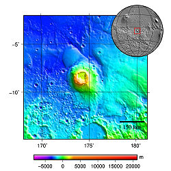
Topography map of Apollinaris Mons
Coordinates 9°18′S174°24′E / 9.3°S 174.4°E / -9.3; 174.4 Coordinates: 9°18′S174°24′E / 9.3°S 174.4°E / -9.3; 174.4 [1]

Apollinaris Mons [1] is an ancient shield volcano in the southern hemisphere of Mars. It is situated near the equator, south of Elysium Planitia and north of the impact crater Gusev (the landing site of the Mars rover Spirit ). Elysium Planitia separates it from the volcanic province of Elysium to its northwest. The volcano's caldera is named Apollinaris Patera; [2] this name formerly applied to the whole edifice.

Contents

Apollinaris Mons is about 5 kilometres high with a base about 296 kilometres in diameter. [3] On the top of this volcano is a caldera about 80 km (50 miles) in diameter. The volcano is approximately 3 billion [4] to 3.5 billion years old. [5]

It was named in 1973 after a mountain spring near Rome in Italy.

A study using a global climate model found that the Medusae Fossae Formation could have been formed from ash from Apollinaris Mons, Arsia Mons, and possibly Pavonis Mons. [6]

Paleomagnetic field studies

Apollinaris Patera parallels many of the volcanic terrains on Mars, including most of the Elysium and Tharsis Rises, in that they are demagnetized terrains that conspicuously predate the shutdown of the Martian dynamo. The mechanism of its deactivation has been compared to that of Hadriacus Mons. Researchers observing this noted that the deposition of lavas atop an older, more magnetized terrain might have led to the region's demagnetization. Its existence thus does not challenge hypotheses about the timing of the dynamo shutdown. [7]

Interactive Mars map

Interactive image map of the global topography of Mars. Hover your mouse over the image to see the names of over 60 prominent geographic features, and click to link to them. Coloring of the base map indicates relative elevations, based on data from the Mars Orbiter Laser Altimeter on NASA's Mars Global Surveyor. Whites and browns indicate the highest elevations (+12 to +8 km); followed by pinks and reds (+8 to +3 km); yellow is 0 km; greens and blues are lower elevations (down to -8 km). Axes are latitude and longitude; Polar regions are noted.
(See also: Mars Rovers map and Mars Memorial map) (view * discuss) Mars Map.JPGCydonia MensaeGale craterHolden craterJezero craterLomonosov craterLyot craterMalea PlanumMaraldi craterMareotis TempeMie craterMilankovič craterSisyphi Planum
Interactive icon.svg Interactive image map of the global topography of Mars. Hover your mouse over the image to see the names of over 60 prominent geographic features, and click to link to them. Coloring of the base map indicates relative elevations, based on data from the Mars Orbiter Laser Altimeter on NASA's Mars Global Surveyor . Whites and browns indicate the highest elevations (+12 to +8 km); followed by pinks and reds (+8 to +3 km); yellow is 0 km; greens and blues are lower elevations (down to −8 km). Axes are latitude and longitude; Polar regions are noted.

See also

Related Research Articles

In planetary nomenclature, a fossa is a long, narrow depression (trough) on the surface of an extraterrestrial body, such as a planet or moon. The term, which means "ditch" or "trench" in Latin, is not a geological term as such but a descriptor term used by the United States Geological Survey (USGS) and the International Astronomical Union (IAU) for topographic features whose geology or geomorphology is uncertain due to lack of data or knowledge of the exact processes that formed them. Fossae are believed to be the result of a number of geological processes, such as faulting or subsidence. Many fossae on Mars are probably graben.

<span class="mw-page-title-main">Alba Mons</span> Martian volcano

Alba Mons is a volcano located in the northern Tharsis region of the planet Mars. It is the biggest volcano on Mars in terms of surface area, with volcanic flow fields that extend for at least 1,350 km (840 mi) from its summit. Although the volcano has a span comparable to that of the United States, it reaches an elevation of only 6.8 km (22,000 ft) at its highest point. This is about one-third the height of Olympus Mons, the tallest volcano on the planet. The flanks of Alba Mons have very gentle slopes. The average slope along the volcano's northern flank is 0.5°, which is over five times lower than the slopes on the other large Tharsis volcanoes. In broad profile, Alba Mons resembles a vast but barely raised welt on the planet's surface. It is a unique volcanic structure with no counterpart on Earth or elsewhere on Mars.

<span class="mw-page-title-main">Hecates Tholus</span> Martian volcano

Hecates Tholus is a Martian volcano, notable for results from the European Space Agency's Mars Express mission which indicate a major eruption took place 350 million years ago. The eruption created a caldera 10 km in diameter on the volcano's western flank.

<span class="mw-page-title-main">Cerberus (Mars)</span> Crater on Mars

Cerberus is a large "dark spot" located on Mars and named after the mythical dog Cerberus. The arcuate (curved) markings in the upper right are in the Amazonis plains and may be sand drifts. The volcano Elysium Mons, a yellow area north of Cerberus, has several channels radiating from its flanks. The three bright spots, upper left, are volcanoes partially veiled by thin clouds.

<span class="mw-page-title-main">Elysium (volcanic province)</span> 2nd-largest volcanic region of Mars

Elysium, located in the Elysium and Cebrenia quadrangles, is the second largest volcanic region on Mars, after Tharsis. The region includes the volcanoes Hecates Tholus, Elysium Mons and Albor Tholus. The province is centered roughly on Elysium Mons at 24.7°N 150°E. Elysium Planitia is a broad plain to the south of Elysium, centered at 3.0°N 154.7°E. Another large volcano, Apollinaris Mons, lies south of Elysium Planitia and is not part of the province. Besides having large volcanoes, Elysium has several areas with long trenches, called fossa or fossae (plural) on Mars. They include the Cerberus Fossae, Elysium Fossae, Galaxias Fossae, Hephaestus Fossae, Hyblaeus Fossae, Stygis Fossae and Zephyrus Fossae.

<span class="mw-page-title-main">Elysium Mons</span> Martian volcano

Elysium Mons is a volcano on Mars located in the volcanic province Elysium, at 25.02°N 147.21°E, in the Martian eastern hemisphere. It stands about 12.6 km (41,000 ft) above its base, and about 14.1 km (46,000 ft) above the Martian datum, making it the third tallest Martian mountain in terms of relief and the fourth highest in elevation. Its diameter is about 240 km (150 mi), with a summit caldera about 14 km (8.7 mi) across. It is flanked by the smaller volcanoes Hecates Tholus to the northeast, and Albor Tholus to the southeast.

<span class="mw-page-title-main">Cerberus Fossae</span> Series of semi-parallel fissures on Mars formed by faults

The Cerberus Fossae are a series of semi-parallel fissures on Mars formed by faults which pulled the crust apart in the Cerberus region. They are 1235 km across and centered at 11.28 °N and 166.37 °E. Their northernmost latitude is 16.16 °N and their southernmost latitude 6.23 °N. Their easternmost and westernmost longitudes are 174.72 °E and 154.43 °E, respectively. They can be seen in the Elysium quadrangle.

<span class="mw-page-title-main">Albor Tholus</span> Martian volcano

Albor Tholus is an extinct volcano in the volcanic province Elysium on Mars. It lies south of the neighbouring volcanoes Elysium Mons and Hecates Tholus. Albor Tholus is 4.5 kilometres high and has a diameter of 160 km at its base. Its large caldera, having a diameter of 30 km and a depth of 3 km, is deep compared to calderas on the Earth. The elevation of the lowest level of the caldera is the same as the base of the volcano; however, the original lower slopes of Albor Tholus may have been covered by lava flows from its larger neighbor, Elysium Mons. Evaluations by the Mars probe Mars Express found that the volcanoes of the Elysium region were active over long periods.

<span class="mw-page-title-main">Biblis Tholus</span> Martian volcano

Biblis Tholus is an extinct Martian volcano located at 2.55°N 235.62°E, one of two volcanoes near the center of the Tharsis volcanism. Along with Ulysses Tholus, it is almost midway between Olympus Mons and the Tharsis Montes. Biblis Tholus lies in the Tharsis quadrangle. It is approximately 170 kilometers (110 mi) long and 100 kilometers (62 mi) wide, rising about 3 kilometers (1.9 mi) from its surroundings.

<span class="mw-page-title-main">Volcanism on Mars</span> Overview of volcanism in the geological history of Mars

Volcanic activity, or volcanism, has played a significant role in the geologic evolution of Mars. Scientists have known since the Mariner 9 mission in 1972 that volcanic features cover large portions of the Martian surface. These features include extensive lava flows, vast lava plains, and the largest known volcanoes in the Solar System. Martian volcanic features range in age from Noachian to late Amazonian, indicating that the planet has been volcanically active throughout its history, and some speculate it probably still is so today. Both Earth and Mars are large, differentiated planets built from similar chondritic materials. Many of the same magmatic processes that occur on Earth also occurred on Mars, and both planets are similar enough compositionally that the same names can be applied to their igneous rocks and minerals.

<span class="mw-page-title-main">Medusae Fossae Formation</span> Large geological unit of uncertain origin on Mars

The Medusae Fossae Formation is a large geological formation of probable volcanic origin on the planet Mars. It is named for the Medusa of Greek mythology. "Fossae" is Latin for "trenches". The formation is a collection of soft, easily eroded deposits that extends discontinuously for more than 5,000 km along the equator of Mars. Its roughly-shaped regions extend from just south of Olympus Mons to Apollinaris Patera, with a smaller additional region closer to Gale Crater.

<span class="mw-page-title-main">Ceraunius Fossae</span> Set of fractures in the northern Tharsis region of Mars

The Ceraunius Fossae are a set of fractures in the northern Tharsis region of Mars. They lie directly south of the large volcano Alba Mons and consist of numerous parallel faults and tension cracks that deform the ancient highland crust. In places, younger lava flows cover the fractured terrain, dividing it into several large patches or islands. They are found in the Tharsis quadrangle.

<span class="mw-page-title-main">Ulysses Tholus</span> Martian volcano

Ulysses Tholus is a Martian volcano. It is located in the Tharsis quadrangle at 2.89° north latitude and 121.55° west longitude. It is 58 km across and is named after a classical albedo feature. Ulysses Tholus is immediately east and slightly north of another volcano, Biblis Tholus. The name of the mountain itself was changed on September 19, 2007. The former terminology, Ulysses Patera, now applies only to the central caldera, whereas formerly it had applied to the whole edifice. Tholus describes a volcanic edifice somewhat smaller than would be implied by mons.

<span class="mw-page-title-main">Ulysses Fossae</span>

The Ulysses Fossae are a group of troughs in the Tharsis quadrangle of Mars at 10.06° north latitude and 123.07° west longitude. They were named after an albedo feature name. The area contains pitted cones called Ulysses Colles which were interpreted to be possible Martian equivalents to terrestrial cinder cones.

<span class="mw-page-title-main">Tyrrhenus Mons</span> Martian volcano

Tyrrhenus Mons, formerly Tyrrhena Mons or Tyrrhena Patera, is a large volcano in the Mare Tyrrhenum quadrangle of Mars, located at 21.36° south latitude and 253.47° west longitude. The name "Tyrrhena Patera" now refers only to the central depression, a volcanic crater or caldera. It was named after a classical albedo feature name. Pit chains are found at the summit of Tyrrhenus Mons. They are formed by collapse of material into underground voids. Since they form chains and concentric fractures that are aligned, they are probably caused by extension of the surface. Volcanic processes made the crust pull apart. Voids were formed, then material fell into them, leaving holes. It is one of the oldest volcanoes on Mars. As a consequence of its old age, Tyrrhenus Mons has many radiating gullies on its slope. When it was formed, magma may have gone through frozen ground and then erupted as easily eroded ash, instead of lava flows.

<span class="mw-page-title-main">Tartarus Montes</span> Mountain range on Mars

The Tartarus Montes are a mountain range on the planet Mars, stretching over 1070 km and located around the coordinates 15.46º N, 167.54º E, between Orcus Patera and the Elysium volcanic region.

<span class="mw-page-title-main">Hadriacus Mons</span> Martian volcano

Hadriacus Mons is an ancient, low-relief volcanic mountain on the planet Mars, located in the southern hemisphere just northeast of the impact basin Hellas and southwest of the similar volcano Tyrrhenus Mons. Hadriacus Mons is in the Hellas quadrangle. It has a diameter of 450 kilometres (280 mi). The name was approved in 2007. The flanks of Hadriacus Mons have been eroded into gullies; its southern slopes are incised by the outflow channel Dao Vallis. The large extent of volcanic deposits and the caldera size leads some researchers to suggest that these features were the result of an explosive event caused by a contact between magma and groundwater.

<span class="mw-page-title-main">Elysium Planitia</span> Broad plain that straddles the equator of Mars

Elysium Planitia, located in the Elysium and Aeolis quadrangles, is a broad plain that straddles the equator of Mars, centered at 3.0°N 154.7°E. It lies to the south of the volcanic province of Elysium, the second largest volcanic region on the planet, after Tharsis. Elysium contains the major volcanoes Elysium Mons, Albor Tholus and Hecates Tholus. Another more ancient shield volcano, Apollinaris Mons, is situated just to the south of eastern Elysium Planitia. Within the plains, Cerberus Fossae is the only Mars location with recent volcanic eruptions. Lava flows dated no older than 0.2 million years from the present have been found, and evidence has been found that volcanic activity may have occurred as recently as 53,000 years ago. Such activity could have provided the environment, in terms of energy and chemicals, needed to support life forms.

The Thaumasia Plateau is a vast sloping volcanic plain in the western hemisphere of Mars, and is the most extensive component of the Tharsis Rise by area. Syria Planum, Solis Planum, Sinai Planum, and Thaumasia Planum are the constituent sectors of the plateau, which sits between 8 km and 4 km above the surrounding southern highlands. It is bounded by vestigial basement terrains that predate the formation of Tharsis. This area has been proposed to be a drainage basin that sourced the floodwaters forming the outflow channels surrounding Chryse Planitia.

References

  1. 1 2 "Apollinaris Mons". Gazetteer of Planetary Nomenclature. USGS Astrogeology Science Center . Retrieved 2012-06-30.
  2. "Apollinaris Patera". Gazetteer of Planetary Nomenclature. USGS Astrogeology Science Center . Retrieved 2012-06-30.
  3. "Google Mars". www.google.com. Retrieved 12 June 2019.
  4. "APOD: May 13, 1999 - Mars Volcano Apollinaris Patera". apod.nasa.gov. Retrieved 12 June 2019.
  5. "23. Apollinaris Patera Elysium Planitia, Mars". www.lpi.usra.edu. Retrieved 12 June 2019.
  6. Kerber L., et al. 2012. The disporsal of pyroclasts from ancient explosive volcanoes on Mars: Implications for the friable layered deposits. Icarus. 219:358-381.
  7. Morschhauser, AM; Vervelidou, F; Thomas, P; Grott, M; Lesur, V; Gilder, SA (2018). "Mars' Crustal Magnetic Field". Magnetic Fields in the Solar System. Dordrecht: Springer. ISBN   9783319642918.