Uzboi Vallis

Last updated
Uzboi Vallis
Uzboi Vallis based on day THEMIS.png
Uzboi Vallis based on THEMIS day-time image
Coordinates 29°48′S37°06′W / 29.8°S 37.1°W / -29.8; -37.1
Length366.0
NamingDry riverbed
in Turkmenistan.

Uzboi Vallis is a valley lying situated within the Margaritifer Sinus quadrangle (MC-19) region on Mars. It is named after the Uzboy dry channel, [1] now in Turkmenistan, which repeatedly served as the main channel of the Amu Darya river. The valley begins on the northern rim of the Argyre basin, and cuts through several craters, before ending at Holden crater.
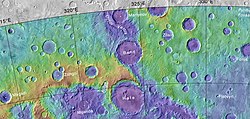
Uzboi Vallis is believed to have been formed by running water. It is believed that layers were formed on the floor of Uzboi Vallis (as shown in the HiRISE image below) when drainage was blocked by the impact that formed Holden Crater to the north. Eventually the lake in the area of Uzboi Vallis went high enough to overtop the rim of Holden. [2] The water then eroded the deposits to expose the layers as they are today. The sediments that make up the layers appear to be coarse in size, suggesting they were probably formed by a rapid flow. [3] [4] [5] [6] The more narrow and sinuous Nirgal Vallis ends at Uzboi Vallis and emptied into it.

It has been suggested that Uzboi, Ladon, Margaritifer and Ares Valles, although now separated by large craters, once comprised a single outflow channel flowing north into Chryse Planitia. [7] [8] The source of this outflow has been suggested as overflow from the Argyre crater, formerly filled to the brim as a lake by channels (Surius, Dzigai, and Palacopus Valles) draining down from the south pole. If real, the full length of this drainage system would be over 8000 km, the longest known drainage path in the solar system. This system has been called the Uzboi-Landon-Morava (ULM) system.

Related Research Articles

Vallis or valles is the Latin word for valley. It is used in planetary geology to name landform features on other planets.

<span class="mw-page-title-main">Argyre Planitia</span> Crater on Mars

Argyre Planitia is a plain located within the impact basin Argyre in the southern highlands of Mars. Its name comes from a map produced by Giovanni Schiaparelli in 1877; it refers to Argyre, a mythical island of silver in Greek mythology.

<span class="mw-page-title-main">Holden (Martian crater)</span> Martian crater

Holden is a 140 km wide crater situated within the Margaritifer Sinus quadrangle (MC-19) region of the planet Mars, located with the southern highlands. It is named after American astronomer Edward Singleton Holden. It is part of the Uzboi-Landon-Morava (ULM) system.

<span class="mw-page-title-main">Ares Vallis</span> Vallis on Mars

Ares Vallis is an outflow channel on Mars, named after the Greek name for Mars: Ares, the god of war; it appears to have been carved by fluids, perhaps water. The valley 'flows' northwest out of the hilly Margaritifer Terra, where the Iani Chaos depression 180 km (110 mi) long and 200 km (120 mi) wide) is connected to the beginning of Ares Vallis by a 100 km (62 mi) wide transition zone centered on 342.5° East and 3° North. It then continues through the ancient Xanthe Terra highlands, and ends in a delta-like region of Chryse Planitia. Ares Vallis was the landing site of NASA's Mars Pathfinder spacecraft, which studied a region of the valley near the border with Chryse in 1997.

<span class="mw-page-title-main">Memnonia quadrangle</span> Map of Mars

The Memnonia quadrangle is one of a series of 30 quadrangle maps of Mars used by the United States Geological Survey (USGS) Astrogeology Research Program. The Memnonia quadrangle is also referred to as MC-16.

<span class="mw-page-title-main">Margaritifer Terra</span> Terra on Mars

Margaritifer Terra is an ancient, heavily cratered region of Mars. It is centered just south of the Martian equator at 4.9°S 25°W and covers 2600 km at its widest extent. The area reveals "chaos terrain", outflow channels, and alluvial plains that are indicative of massive flooding. Wind erosion patterns are also in evidence. A region within the terra shows some of the highest valley network densities on the planet. Ares Vallis is another notable feature, where the flood and flow patterns are in evidence; it was the landing site of the Soviet Mars 6 lander and NASA's Mars Pathfinder. It is also one of several proposed landing sites for the Mars 2020 Rover.

<span class="mw-page-title-main">Amenthes quadrangle</span> Map of Mars

The Amenthes quadrangle is one of a series of 30 quadrangle maps of Mars used by the United States Geological Survey (USGS) Astrogeology Research Program. The Amenthes quadrangle is also referred to as MC-14. The quadrangle covers the area from 225° to 270° west longitude and from 0° to 30° north latitude on Mars. Amenthes quadrangle contains parts of Utopia Planitia, Isidis Planitia, Terra Cimmeria, and Tyrrhena Terra.

<span class="mw-page-title-main">Elysium quadrangle</span> One of 30 quadrangle maps of Mars used by the US Geological Survey

The Elysium quadrangle is one of a series of 30 quadrangle maps of Mars used by the United States Geological Survey (USGS) Astrogeology Research Program. The Elysium quadrangle is also referred to as MC-15.

<span class="mw-page-title-main">Lunae Palus quadrangle</span> Quadrangle map of Mars

The Lunae Palus quadrangle is one of a series of 30 quadrangle maps of Mars used by the United States Geological Survey (USGS) Astrogeology Research Program. The quadrangle is also referred to as MC-10. Lunae Planum and parts of Xanthe Terra and Chryse Planitia are found in the Lunae Palus quadrangle. The Lunae Palus quadrangle contains many ancient river valleys.

<span class="mw-page-title-main">Oxia Palus quadrangle</span> Map of Mars

The Oxia Palus quadrangle is one of a series of 30 quadrangle maps of Mars used by the United States Geological Survey (USGS) Astrogeology Research Program. The Oxia Palus quadrangle is also referred to as MC-11.

<span class="mw-page-title-main">Coprates quadrangle</span> Map of Mars

The Coprates quadrangle is one of a series of 30 quadrangle maps of Mars used by the United States Geological Survey (USGS) Astrogeology Research Program. The Coprates quadrangle is also referred to as MC-18. The Coprates quadrangle contains parts of many of the old classical regions of Mars: Sinai Planum, Solis Planum, Thaumasia Planum, Lunae Planum, Noachis Terra, and Xanthe Terra.

<span class="mw-page-title-main">Margaritifer Sinus quadrangle</span> One of a series of 30 quadrangle maps of Mars

The Margaritifer Sinus quadrangle is one of a series of 30 quadrangle maps of Mars used by the United States Geological Survey (USGS) Astrogeology Research Program. The Margaritifer Sinus quadrangle is also referred to as MC-19. The Margaritifer Sinus quadrangle covers the area from 0° to 45° west longitude and 0° to 30° south latitude on Mars. Margaritifer Sinus quadrangle contains Margaritifer Terra and parts of Xanthe Terra, Noachis Terra, Arabia Terra, and Meridiani Planum.

<span class="mw-page-title-main">Argyre quadrangle</span> Map of Mars

The Argyre quadrangle is one of a series of 30 quadrangle maps of Mars used by the United States Geological Survey (USGS) Astrogeology Research Program. The Argyre quadrangle is also referred to as MC-26. It contains Argyre Planitia and part of Noachis Terra.

<span class="mw-page-title-main">Nirgal Vallis</span> Vallis on Mars

Nirgal Vallis is a long river channel bordering the Coprates quadrangle and Margaritifer Sinus quadrangle of Mars at 28.4° south latitude and 42° west longitude. It is 610 km long and is named after Nergal, the Babylonian god of war and counterpart to the Roman god of war Mars. Nirgal Vallis had a discharge of 4800 cubic meters/second. The western half of Nirgal Valles is a branched system, but the eastern half is a tightly sinuous, deeply entrenched valley. Nirgal Valles ends at Uzboi Vallis. Tributaries are very short and end in steep-walled valley heads, often called "amphitheater-headed valleys." The shape of these valley heads is like cirques on the Earth.

<span class="mw-page-title-main">Outflow channels</span> Long, wide swathes of scoured ground on Mars

Outflow channels are extremely long, wide swathes of scoured ground on Mars. They extend many hundreds of kilometers in length and are typically greater than one kilometer in width. They are thought to have been carved by huge outburst floods.

<span class="mw-page-title-main">Ladon Valles</span> River valley system on Mars

The Ladon Valles are a river valley system lying within the Margaritifer Sinus quadrangle (MC-19) region of the planet Mars located at 22.6° South and 28.7° West. They are 278 km long and were named after an ancient name for a Greek river.

Chaos terrain on Mars is distinctive; nothing on Earth compares to it. Chaos terrain generally consists of irregular groups of large blocks, some tens of kilometers across and a hundred or more meters high. The tilted and flat topped blocks form depressions hundreds of metres deep. A chaotic region can be recognized by a rat's nest of mesas, buttes, and hills, chopped through with valleys which in places look almost patterned. Some parts of this chaotic area have not collapsed completely—they are still formed into large mesas, so they may still contain water ice. Chaos regions formed long ago. By counting craters and by studying the valleys' relations with other geological features, scientists have concluded the channels formed 2.0 to 3.8 billion years ago.

<span class="mw-page-title-main">Aurorae Chaos</span>

Aurorae Chaos is a region of chaos terrain on Mars at the eastern end of the outflow channels from Valles Marineris into Chryse Planitia, centered at approximately ~324°E, 9°S. It is in the Margaritifer Sinus quadrangle.

<span class="mw-page-title-main">Lakes on Mars</span> Overview of the presence of lakes on Mars

In summer 1965, the first close-up images from Mars showed a cratered desert with no signs of water. However, over the decades, as more parts of the planet were imaged with better cameras on more sophisticated satellites, Mars showed evidence of past river valleys, lakes and present ice in glaciers and in the ground. It was discovered that the climate of Mars displays huge changes over geologic time because its axis is not stabilized by a large moon, as Earth's is. Also, some researchers maintain that surface liquid water could have existed for periods of time due to geothermal effects, chemical composition or asteroid impacts. This article describes some of the places that could have held large lakes.

The Uzboi-Landon-Morava (ULM) outflow system is a long series of channels and depressions that may have carried water across a major part of Mars. It starts with channels that drain into the Argyre basin in the Argyre quadrangle. Water ponded in the Argyre basin, then the overflow is believed to have traveled northward through Uzboi Vallis, into Landon basin, through Morava Valles, to the floor of Margaritifer basin. Some of the water may have helped to carve Ares Vallis. Altogether, the total area drained for this watershed may have been about 11 X 106 km2 or about 9% of Mars.

References

  1. "Uzboi Vallis". Gazetteer of Planetary Nomenclature. USGS Astrogeology Research Program.
  2. "An Ancient Lake in Uzboi Vallis, Mars" (PDF). Retrieved 2024-01-18.
  3. "HiRISE | Layers in Uzboi Vallis (PSP_008338_1525)".
  4. "HiRISE | A Closer Look at Holden Crater (PSP_003077_1530)".
  5. Grant, J., T. Parker. 2002. Drainage evolution of the Margaritifer Sinus region, Mars. J. Geophysic. Res. 107, doi:10.1029/2001JE001678.
  6. Grant, J. et al. 2008. HiRISE imaging of impact megabreccia and sub-meter aqueous strata in Holden Crater, Mars. Geology: 36, 195-198.
  7. Grant, J. et al. 2010. A lake in Uzboi Vallis and implications for late Noachian-Early Hesperian climate on Mars. Icarus: 212, 110-122
  8. Parker, T.J., Clifford, S.m., and Banerdt, W.B. (2000). Argyre Planitia and the Mars global hydrologic cycle. LPSC XXXI, Abstract 2033.