
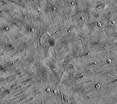


 Jezero crater and region
 Water-rich terrain
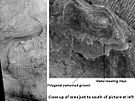 Possible channel bringing sediment to the crater
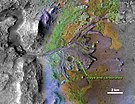 Jezero crater delta - chemical alteration by water (hi-res)
 Detected clay materials suggest an ancient lake
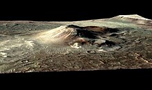
 Mars digital-image mosaic merged with color of the MC-13 quadrangle, Syrtis Major region of Mars. | |
| Feature type | Shield volcano |
|---|---|
| Coordinates | 8°24′N69°30′E / 8.4°N 69.5°E |
| Diameter | ~1 300 km [1] |
| Peak | ~2.3 km [2] |
| Discoverer | Christiaan Huygens |
| Eponym | Gulf of Sidra |
Syrtis Major Planum (formerly Syrtis Major Planitia) is a massive shield volcano in the eastern hemisphere of Mars. A "dark spot" (an albedo feature), Syrtis Major Planum is located in the boundary between the northern lowlands and southern highlands of Mars just west of the impact basin Isidis in the Syrtis Major quadrangle. It was formerly believed to be a plain, and was therefore described as a planitia. Later data from the Mars Global Surveyor revealed that it is actually a broad topographic rise. [2] The dark color of Syrtis Major Planum comes from the basaltic volcanic rock of the region and the relative lack of dust.
Contents
- Geography and geology
- Discovery and name
- Seasonal variations
- Nili Patera Caldera
- Moving sand dunes and ripples
- Gallery
- See also
- References
- External links
The selected landing site for the Mars 2020 mission that includes the rover Perseverance and the helicopter drone Ingenuity was Jezero crater, at 18°51′18″N77°31′08″E / 18.855°N 77.519°E [3] within the region. [4] The northeastern region of Syrtis Major Planum was also considered a potential landing site.


