
Syrtis Major Planum is a massive shield volcano in the eastern hemisphere of Mars. A "dark spot", Syrtis Major Planum is located in the boundary between the northern lowlands and southern highlands of Mars just west of the impact basin Isidis in the Syrtis Major quadrangle. It was formerly believed to be a plain, and was therefore described as a planitia. Later data from the Mars Global Surveyor revealed that it is actually a broad topographic rise. The dark color of Syrtis Major Planum comes from the basaltic volcanic rock of the region and the relative lack of dust.

Gusev is a crater on the planet Mars and is located at 14.5°S 175.4°E and is in the Aeolis quadrangle. The crater is about 166 kilometers in diameter and formed approximately three to four billion years ago. It was named after Russian astronomer Matvey Gusev (1826–1866) in 1976.

Holden is a 140 km wide crater situated within the Margaritifer Sinus quadrangle (MC-19) region of the planet Mars, located with the southern highlands. It is named after American astronomer Edward Singleton Holden. It is part of the Uzboi-Landon-Morava (ULM) system.

Isidis Planitia is a plain located within a giant impact basin on Mars, located partly in the Syrtis Major quadrangle and partly in the Amenthes quadrangle. At approximately 1,900 km (1,200 mi) in diameter, it is the third-largest confirmed impact structure on the planet, after the Hellas and Utopia basins. Isidis was likely the last major basin to be formed on Mars, having formed approximately 3.9 billion years ago during the Noachian period, by an impactor around 200 kilometres (120 mi) in diameter. Due to dust coverage, it typically appears bright in telescopic views, and was mapped as a classical albedo feature, Isidis Regio, visible by telescope in the pre-spacecraft era.

Eberswalde, formerly known as Holden NE, is a partially buried impact crater in Margaritifer Terra, Mars. Eberswalde crater lies just to the north of Holden, a large crater that may have been a lake. The 65.3-km-diameter crater, centered at 24°S, 33°W, is named after the German town of the same name, in accordance with the International Astronomical Union's rules for planetary nomenclature. It was one of the final four proposed landing sites for the Mars rover Mars Science Laboratory mission. This extraterrestrial geological feature lies situated within the Margaritifer Sinus quadrangle (MC-19) region of Mars. Although not chosen, it was considered a potential landing site for the Mars 2020 Perseverance rover, and in the second Mars 2020 Landing Site Workshop it survived the cut and was among the top eight sites still in the running.

The formation of carbonates on Mars have been suggested based on evidence of the presence of liquid water and atmospheric carbon dioxide in the planet's early stages. Moreover, due to their utility in registering changes in environmental conditions such as pH, temperature, fluid composition, carbonates have been considered as a primary target for planetary scientists' research. However, since their first detection in 2008, the large deposits of carbonates that were once expected on Mars have not been found, leading to multiple potential explanations that can explain why carbonates did not form massively on the planet.

Mawrth Vallis is a valley on Mars, located in the Oxia Palus quadrangle at 22.3°N, 343.5°E with an elevation approximately two kilometers below datum. Situated between the southern highlands and northern lowlands, the valley is a channel formed by massive flooding which occurred in Mars’ ancient past. It is an ancient water outflow channel with light-colored clay-rich rocks.

Jezero is a crater on Mars in the Syrtis Major quadrangle, about 45.0 km (28.0 mi) in diameter. Thought to have once been flooded with water, the crater contains a fan-delta deposit rich in clays. The lake in the crater was present when valley networks were forming on Mars. Besides having a delta, the crater shows point bars and inverted channels. From a study of the delta and channels, it was concluded that the lake inside the crater probably formed during a period in which there was continual surface runoff.
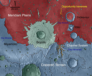
Miyamoto is a crater within the Margaritifer Sinus quadrangle (MC-19) region of the planet Mars, west of the Plains of Meridiani. It is 150 kilometers (93 mi) wide. Its northeastern half is filled with rocks formed in the presence of water and include minerals of iron and sulfur, which likely settled on lake bottoms or in groundwater systems. In the southwestern half of the crater floor, erosion has stripped these materials away, revealing clays and other materials like those found in the most ancient Martian rocks. More than 3.5 billion years old, they date to the Noachian era at which time, liquid water was likely present at the surface and could have created an environment favorable to life.

The Syrtis Major quadrangle is one of a series of 30 quadrangle maps of Mars used by the United States Geological Survey (USGS) Astrogeology Research Program. The Syrtis Major quadrangle is also referred to as MC-13.

The Amenthes quadrangle is one of a series of 30 quadrangle maps of Mars used by the United States Geological Survey (USGS) Astrogeology Research Program. The Amenthes quadrangle is also referred to as MC-14. The quadrangle covers the area from 225° to 270° west longitude and from 0° to 30° north latitude on Mars. Amenthes quadrangle contains parts of Utopia Planitia, Isidis Planitia, Terra Cimmeria, and Tyrrhena Terra.

The Iapygia quadrangle is one of a series of 30 quadrangle maps of Mars used by the United States Geological Survey (USGS) Astrogeology Research Program. The Iapygia quadrangle is also referred to as MC-21. It was named after the heel of the boot of Italy. That name was given by the Greeks It is part of a region of Italy named Apulia. The name Iapygia was approved in 1958.

The Mare Tyrrhenum quadrangle is one of a series of 30 quadrangle maps of Mars used by the United States Geological Survey (USGS) Astrogeology Research Program. This quadrangle is also referred to as MC-22. It contains parts of the regions Tyrrhena Terra, Hesperia Planum, and Terra Cimmeria.
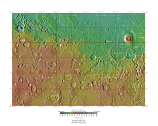
The Aeolis quadrangle is one of a series of 30 quadrangle maps of Mars used by the United States Geological Survey (USGS) Astrogeology Research Program. The Aeolis quadrangle is also referred to as MC-23 . The Aeolis quadrangle covers 180° to 225° W and 0° to 30° south on Mars, and contains parts of the regions Elysium Planitia and Terra Cimmeria. A small part of the Medusae Fossae Formation lies in this quadrangle.
Mars may contain ores that would be very useful to potential colonists. The abundance of volcanic features together with widespread cratering are strong evidence for a variety of ores. While nothing may be found on Mars that would justify the high cost of transport to Earth, the more ores that future colonists can obtain from Mars, the easier it would be to build colonies there.

The composition of Mars covers the branch of the geology of Mars that describes the make-up of the planet Mars.

Hargraves is a Hesperian-age complex double-layered ejecta impact crater on Mars. It was emplaced near the crustal dichotomy in the vicinity of the Nili Fossae, the Syrtis Major volcanic plains, and the Isidis impact basin, and is situated within the Syrtis Major quadrangle. Hargraves has been the target of focused study because its ejecta apron is particularly well-preserved for a Martian crater of its size. It has been analogized to similar double-layered ejecta blankets on Earth, including that of the Ries impact structure, which was where the conceptual model for how such craters formed was first advanced.

In summer 1965, the first close-up images from Mars showed a cratered desert with no signs of water. However, over the decades, as more parts of the planet were imaged with better cameras on more sophisticated satellites, Mars showed evidence of past river valleys, lakes and present ice in glaciers and in the ground. It was discovered that the climate of Mars displays huge changes over geologic time because its axis is not stabilized by a large moon, as Earth's is. Also, some researchers maintain that surface liquid water could have existed for periods of time due to geothermal effects, chemical composition, or asteroid impacts. This article describes some of the places that could have held large lakes.
Linear ridge networks are found in various places on Mars in and around craters. These features have also been called "polygonal ridge networks", "boxwork ridges", and "reticulate ridges". Ridges often appear as mostly straight segments that intersect in a lattice-like manner. They are hundreds of meters long, tens of meters high, and several meters wide. It is thought that impacts created fractures in the surface, these fractures later acted as channels for fluids. Fluids cemented the structures. With the passage of time, surrounding material was eroded away, thereby leaving hard ridges behind. It is reasonable to think that on Mars impacts broke the ground with cracks since faults are often formed in impact craters on Earth. One could guess that these ridge networks were dikes, but dikes would go more or less in the same direction, as compared to these ridges that have a large variety of orientations. Since the ridges occur in locations with clay, these formations could serve as a marker for clay which requires water for its formation. Water here could have supported past life in these locations. Clay may also preserve fossils or other traces of past life.

Northeast Syrtis is a region of Mars once considered by NASA as a landing site for the Mars 2020 rover mission. This landing site failed in the competition with Jezero crater, another landing site dozens of kilometers away from Northeast Syrtis. It is located in the northern hemisphere of Mars at coordinates 18°N,77°E in the northeastern part of the Syrtis Major volcanic province, within the ring structure of Isidis impact basin as well. This region contains diverse morphological features and minerals, indicating that water once flowed here. It may be an ancient habitable environment; microbes could have developed and thrived here.


