
Meridiani Planum is a plain located 2 degrees south of Mars's equator, in the westernmost portion of Terra Meridiani. It hosts a rare occurrence of gray crystalline hematite. On Earth, hematite is often formed in hot springs or in standing pools of water; therefore, many scientists believe that the hematite at Meridiani Planum may be indicative of ancient hot springs or that the environment contained liquid water. The hematite is part of a layered sedimentary rock formation about 200 to 800 meters thick. Other features of Meridiani Planum include volcanic basalt and impact craters.

Opportunity, also known as MER-B or MER-1, and nicknamed "Oppy", is a robotic rover that was active on Mars from 2004 until the middle of 2018. Launched on July 7, 2003, as part of NASA's Mars Exploration Rover program, it landed in Meridiani Planum on January 25, 2004, three weeks after its twin Spirit (MER-A) touched down on the other side of the planet. With a planned 90-sol duration of activity, Spirit functioned until it got stuck in 2009 and ceased communications in 2010, while Opportunity was able to stay operational for 5111 sols after landing, maintaining its power and key systems through continual recharging of its batteries using solar power, and hibernating during events such as dust storms to save power. This careful operation allowed Opportunity to exceed its operating plan by 14 years, 46 days, 55 times its designed lifespan. By June 10, 2018, when it last contacted NASA, the rover had traveled a distance of 45.16 kilometers.

The geography of Mars, also known as areography, entails the delineation and characterization of regions on Mars. Martian geography is mainly focused on what is called physical geography on Earth; that is the distribution of physical features across Mars and their cartographic representations.
Airy-0 is a crater on Mars whose location defines the position of the prime meridian of that planet. It is about 0.5 kilometres (0.31 mi) across and lies within the larger crater Airy in the region Sinus Meridiani. The IAU Working Group on Cartographic Coordinates and Rotational Elements has now recommended setting the longitude of the Viking 1 lander as the standard. This definition maintains the position of the center of Airy-0 at 0° longitude, within the tolerance of current cartographic uncertainties.

Davies is a crater on Mars located at 46°N 0°E on the fringe of Acidalia Planitia near Arabia Terra. It is approximately 48 km in diameter. The crater's name was formally approved by the IAU in 2006.
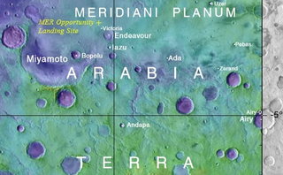
Arabia Terra is a large upland region in the north of Mars that lies mostly in the Arabia quadrangle, but a small part is in the Mare Acidalium quadrangle. It is densely cratered and heavily eroded. This battered topography indicates great age, and Arabia Terra is presumed to be one of the oldest terrains on the planet. It covers as much as 4,500 km (2,800 mi) at its longest extent, centered roughly at 21°N6°E with its eastern and southern regions rising 4 km (13,000 ft) above the north-west. Alongside its many craters, canyons wind through the Arabia Terra, many emptying into the large northern lowlands of the planet, which borders Arabia Terra to the north.

Schiaparelli is an impact crater on Mars, located near the planet's equator at latitude 3° south and longitude 344° in the Sinus Sabaeus quadrangle. It measures approximately 459 kilometers in diameter and was named after Italian astronomer Giovanni Schiaparelli, known for his observations of the Red Planet and his mistranslated term "canali". The name was adopted by IAU's Working Group for Planetary System Nomenclature in 1973.

Tempe Terra is a heavily cratered highland region in the northern hemisphere of the planet Mars. Located at the northeastern edge of the Tharsis volcanic province, Tempe Terra is notable for its high degree of crustal fracturing and deformation. The region also contains many small shield volcanoes, lava flows, and other volcanic structures.

Heinlein is a crater in Promethei Terra, in the southeast end of the Hellas quadrangle of Mars. Centered at 64.6 degrees south, 243.8 degrees west, it is 83 km in diameter. It is named after Robert A. Heinlein, a leading science fiction author.

The Casius quadrangle is one of a series of 30 quadrangle maps of Mars used by the United States Geological Survey (USGS) Astrogeology Research Program. The quadrangle is located in the north-central portion of Mars’ eastern hemisphere and covers 60° to 120° east longitude and 30° to 65° north latitude. The quadrangle uses a Lambert conformal conic projection at a nominal scale of 1:5,000,000 (1:5M). The Casius quadrangle is also referred to as MC-6. Casius quadrangle contains part of Utopia Planitia and a small part of Terra Sabaea. The southern and northern borders of the Casius quadrangle are approximately 3,065 km and 1,500 km wide, respectively. The north to south distance is about 2,050 km. The quadrangle covers an approximate area of 4.9 million square km, or a little over 3% of Mars’ surface area.

The Arabia quadrangle is one of a series of 30 quadrangle maps of Mars used by the United States Geological Survey (USGS) Astrogeology Research Program. The Arabia quadrangle is also referred to as MC-12.
The Sinus Sabaeus quadrangle is one of a series of 30 quadrangle maps of Mars used by the United States Geological Survey (USGS) Astrogeology Research Program. It is also referred to as MC-20 . The Sinus Sabaeus quadrangle covers the area from 315° to 360° west longitude and 0° to 30° degrees south latitude on Mars. It contains Schiaparelli, a large, easily visible crater that sits close to the equator. The Sinus Sabaeus quadrangle contains parts of Noachis Terra and Terra Sabaea.

The Mare Australe quadrangle is one of a series of 30 quadrangle maps of Mars used by the United States Geological Survey (USGS) Astrogeology Research Program. The Mare Australe quadrangle is also referred to as MC-30. The quadrangle covers all the area of Mars south of 65°, including the South polar ice cap, and its surrounding area. The quadrangle's name derives from an older name for a feature that is now called Planum Australe, a large plain surrounding the polar cap. The Mars polar lander crash landed in this region.

Lyot is a large peak ring crater in the Vastitas Borealis region of Mars, located at 50.8° north latitude and 330.7° west longitude within the Ismenius Lacus quadrangle. It is 236 km in diameter. Its name refers to Bernard Lyot, a French astronomer (1897–1952).

Henry is a large crater in the Arabia quadrangle of Mars. It is 171 kilometres (106 mi) in diameter and was named after the brothers Paul Henry and Prosper Henry, both of whom were French telescope makers and astronomers.

A Ring mold crater is a kind of crater on the planet Mars that looks like the ring molds used in baking. They are believed to be caused by an impact into ice. The ice is covered by a layer of debris. They are found in parts of Mars that have buried ice. Laboratory experiments confirm that impacts into ice result in a "ring mold shape." They are also bigger than other craters in which an asteroid impacted solid rock. Impacts into ice warm the ice and cause it to flow into the ring mold shape. These craters are common in lobate debris aprons and lineated valley fill. Many have been found in Mamers Valles, a channel found along the dichotomy boundary in Deuteronilus Mensae. They may be an easy way for future colonists of Mars to find water ice.

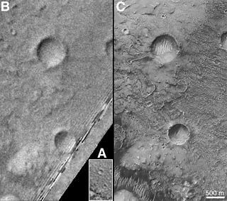
The landscape polewards of around 30 degrees latitude on Mars has a distinctively different appearance to that nearer the equator, and is said to have undergone terrain softening. Softened terrain lacks the sharp ridge crests seen near the equator, and is instead smoothly rounded. This rounding is thought to be caused by high concentrations of water ice in soils. The term was coined in 1986 by Steve Squyres and Michael Carr from examining imagery from the Viking missions to Mars.

Garni is an impact crater on Mars, in which, according to NASA, there is evidence of liquid water. In the press release of its finding on 28 September 2015, NASA considered it "the latest of many breakthroughs" in their Mars exploration. NASA and the US Geological Survey named the crater after the Armenian village of Garni. The naming was approved and adopted by the International Astronomical Union (IAU) on April 24, 2015.
