
Utopia Planitia is a large plain within Utopia, the largest recognized impact basin on Mars and in the Solar System with an estimated diameter of 3300 km. It is the Martian region where the Viking 2 lander touched down and began exploring on September 3, 1976, and the Zhurong rover touched down on 14 May, 2021, as a part of the Tianwen-1 mission. It is located at the antipode of Argyre Planitia, centered at 46.7°N 117.5°E. It is also in the Casius quadrangle, Amenthes quadrangle, and the Cebrenia quadrangle of Mars.
Planetary geology, alternatively known as astrogeology or exogeology, is a planetary science discipline concerned with the geology of the celestial bodies such as the planets and their moons, asteroids, comets, and meteorites. Although the geo- prefix typically indicates topics of or relating to Earth, planetary geology is named as such for historical and convenience reasons; due to the types of investigations involved, it is closely linked with Earth-based geology. These investigations are centered around the composition, structure, processes, and history of a planet.

Cabeus is a lunar impact crater that is located about 100 km (62 mi) from the south pole of the Moon. At this location the crater is seen obliquely from Earth, and it is almost perpetually in deep shadow due to lack of sunlight. Hence, not much detail can be seen of this crater, even from orbit. Through a telescope, this crater appears near the southern limb of the Moon, to the west of the crater Malapert and to the south-southwest of Newton.

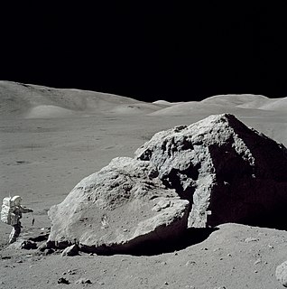
The Astrogeology Science Center is the entity within the United States Geological Survey concerned with the study of planetary geology and planetary cartography. It is housed in the Shoemaker Building in Flagstaff, Arizona. The Center was established in 1963 by Eugene Merle Shoemaker to provide lunar geologic mapping and to assist in training astronauts destined for the Moon as part of the Apollo program.
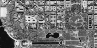
A digital orthophoto quadrangle (DOQ) is aerial photography or satellite imagery that has been corrected so that its pixels are aligned with longitude and latitude lines, and have a narrowly defined region of coverage. This is a widely used format introduced by United States Geological Survey (USGS). The correction technique is called image rectification and is a large part of photogrammetry.

Mons Agnes is a hill ("mountain") on the Moon, in Lacus Felicitatis, inside crater-like feature Ina, at 18.66°N 5.34°E. It has maximal width of approximately 650 m. Its height is more difficult to determine; from Apollo 15 images it was determined as about 30 m, but newer map, based on LRO photos, gives about 10 m.

A "quadrangle" is a topographic map produced by the United States Geological Survey (USGS) covering the United States. The maps are usually named after local physiographic features. The shorthand "quad" is also used, especially with the name of the map; for example, "the Ranger Creek, Texas quad". From approximately 1947-1992, the USGS produced the 7.5 minute series, with each map covering an area one-quarter of the older 15-minute quad series, which it replaced. A 7.5 minute quadrangle map covers an area of 49 to 70 square miles. Both map series were produced via photogrammetric analysis of aerial photography using stereoplotters supplemented by field surveys. These maps employ the 1927 North American Datum (NAD27); conversion or a change in settings is necessary when using a GPS which by default employ the WGS84 geodetic datum. Beginning in 2009, the USGS made available digital versions of 7.5 minute quadrangle maps based on GIS data that use the NAD83 datum, which is typically within one meter of WGS84, or within the uncertainty of most GPS coordinate measurements. On a quadrangle map, the north and south limits are not straight lines, but are actually curved to match Earth's lines of latitude on the standard projection. The east and west limits are usually not parallel as they match Earth's lines of longitude.

The Shakespeare quadrangle is a region of Mercury running from 90 to 180° longitude and 20 to 70° latitude. It is also called Caduceata.

The Beethoven quadrangle is located in the equatorial region of Mercury, in the center of the area imaged by Mariner 10. Most pictures of the quadrangle were obtained at high sun angles as the Mariner 10 spacecraft receded from the planet. Geologic map units are described and classified on the basis of morphology, texture, and albedo, and they are assigned relative ages based on stratigraphic relations and on visual comparisons of the density of superposed craters. Crater ages are established by relative freshness of appearance, as indicated by topographic sharpness of their rim crests and degree of preservation of interior and exterior features such as crater floors, walls, and ejecta aprons. Generally, topography appears highly subdued because of the sun angle, and boundaries between map units are not clearly defined.
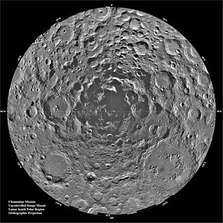
The lunar south pole is the southernmost point on the Moon, at 90°S. It is of special interest to scientists because of the occurrence of water ice in permanently shadowed areas around it. The lunar south pole region features craters that are unique in that the near-constant sunlight does not reach their interior. Such craters are cold traps that contain a fossil record of hydrogen, water ice, and other volatiles dating from the early Solar System. In contrast, the lunar north pole region exhibits a much lower quantity of similarly sheltered craters.

The Maja Valles are a large system of ancient outflow channels in the Lunae Palus quadrangle on Mars. Their location is 12.6° north latitude and 58.3° west longitude. The name is a Nepali word for "Mars". The Maja Valles begin at Juventae Chasma. Parts of the system have been partially buried by thin volcanic debris. The channels end at Chryse Planitia.

Boeddicker is a crater in the Aeolis quadrangle of Mars, located at 15° south latitude and 197.7° west longitude. It is 109 km in diameter and was named after Otto Boeddicker, a German astronomer (1853–1937).

Sirenum Fossae is a long trough in several quadrangles including Memnonia quadrangle and Phaethontis quadrangle of Mars, centered at 35.57° south latitude and 197.26° west longitude. Sirenum Fossae is 2,735 km long and was named after a classical albedo feature name. Troughs on Mars like this one are called Fossae. Sirenum Fossae is believed to have formed by movement along a pair of faults causing a center section to drop down. This kind of feature is called a graben.
Fretted terrain is a type of surface feature common to certain areas of Mars and was discovered in Mariner 9 images. It lies between two different types of terrain. The surface of Mars can be divided into two parts: low, young, uncratered plains that cover most of the northern hemisphere, and high-standing, old, heavily cratered areas that cover the southern and a small part of the northern hemisphere. Between these two zones is a region called the Martian dichotomy and parts of it contain fretted terrain. This terrain contains a complicated mix of cliffs, mesas, buttes, and straight-walled and sinuous canyons. It contains smooth, flat lowlands along with steep cliffs. The scarps or cliffs are usually 1 to 2 km high. Channels in the area have wide, flat floors and steep walls. Fretted terrain shows up in northern Arabia, between latitudes 30°N and 50°N and longitudes 270°W and 360°W, and in Aeolis Mensae, between 10 N and 10 S latitude and 240 W and 210 W longitude. Two good examples of fretted terrain are Deuteronilus Mensae and Protonilus Mensae.

The United States Geological Survey, abbreviated USGS and formerly simply known as the Geological Survey, is a scientific agency of the United States government. The scientists of the USGS study the landscape of the United States, its natural resources, and the natural hazards that threaten it. The organization's work spans the disciplines of biology, geography, geology, and hydrology. The USGS is a fact-finding research organization with no regulatory responsibility.

Nilosyrtis Mensae is an area of Mars in the Casius quadrangle. It is centered on the coordinates of 36.87° N and 67.9° E. Its western and eastern longitudes are 51.1° E and 74.4° E. North and south latitudes are 36.87° N and 29.61° N. Nilosyrtis Mensae is just to the east of Protonilus Mensae and both lie along the Martian dichotomy boundary. Its name was adapted by the IAU in 1973. It was named after a classical albedo feature, and it is 705 km (438 mi) across.
Main is an impact crater on Mars, located in the Mare Australe quadrangle at 76.6°S latitude and 310.9°W longitude. It measures 109.0 kilometers in diameter and was named after Rev. Robert Main. The name was approved in 1973, by the International Astronomical Union (IAU) Working Group for Planetary System Nomenclature (WGPSN). The floor of Main shows dark portions which are caused by pressurized carbon dioxide blowing dust in the atmosphere in the spring when the temperature goes up. Some of the dust is shaped into streaks if there is a wind.

