The Neptune Range is a mountain range, 70 nautical miles long, lying west-southwest of Forrestal Range in the central part of the Pensacola Mountains, Antarctica. The range comprises Washington Escarpment with its associated ridges, valleys and peaks, the Iroquois Plateau, the Schmidt and the Williams Hills.

The Getz Ice Shelf is an ice shelf over 300 nautical miles long and from 20 to 60 nautical miles wide, bordering the Hobbs Coast and Bakutis Coast of Marie Byrd Land, Antarctica, between the McDonald Heights and Martin Peninsula. Several large islands are partially or wholly embedded in the ice shelf.
The Haines Mountains are a range of ice-capped mountains trending northwest–southeast for about 25 nautical miles and forming the southwest wall of Hammond Glacier, in the Ford Ranges of Marie Byrd Land, Antarctica.
The Flood Range is a range of large snow-covered mountains extending in an east–west direction for about 60 nautical miles and forming a right angle with the southern end of the Ames Range in Marie Byrd Land, Antarctica.

The Ames Range is a range of snow-covered, flat-topped, steep-sided mountains, extending in a north–south direction for 20 nautical miles and forming a right angle with the eastern end of the Flood Range in Marie Byrd Land, Antarctica.

The Executive Committee Range is a range consisting of five major volcanoes, which trends north-south for 50 nautical miles along the 126th meridian west, in Marie Byrd Land, Antarctica.
The Clark Mountains are a group of low mountains rising above 1,200 metres (3,900 ft) located in the Ford Ranges, Marie Byrd Land, Antarctica. They are about 10 nautical miles east of the Allegheny Mountains.
Sulzberger Ice Shelf is an ice shelf about 85 nautical miles long and 50 nautical miles wide bordering the coast of Marie Byrd Land between Edward VII Peninsula and Guest Peninsula in Antarctica.
The Guest Peninsula is a snow-covered peninsula about 45 nautical miles long between the Sulzberger Ice Shelf and Block Bay, in the northwest part of Marie Byrd Land, Antarctica.

The Scott Glacier is a major glacier, 120 nautical miles long, that drains the East Antarctic Ice Sheet through the Queen Maud Mountains to the Ross Ice Shelf. The Scott Glacier is one of a series of major glaciers flowing across the Transantarctic Mountains, with the Amundsen Glacier to the west and the Leverett and Reedy glaciers to the east.
The Gothic Mountains is a group of mountains, 20 nautical miles long, in the Queen Maud Mountains of Antarctica, located west of Watson Escarpment and bounded by Scott Glacier, Albanus Glacier, and Griffith Glacier.
Bowyer Butte is a steep-cliffed eminence with a nearly flat summit, 3 nautical miles wide and 1,085 metres (3,560 ft) high, located between the lower ends of the Johnson Glacier and the Venzke Glacier on the coast of Marie Byrd Land, Antarctica.
Nash Ridge is a high, massive ridge of eastern Eisenhower Range, about 10 nautical miles long and 5 nautical miles wide, projecting between the flow of the O'Kane Glacier and Priestley Glacier, in Victoria Land, Antarctica.
Watson Escarpment is a major escarpment in the Queen Maud Mountains, trending northward along the east margin of Scott Glacier, then eastward to Reedy Glacier where it turns southward along the glacier's west side. Somewhat arcuate, the escarpment is nearly 100 nautical miles long, rises 3,550 metres (11,650 ft) above sea level, and 1,000 to 1,500 metres above the adjacent terrain.
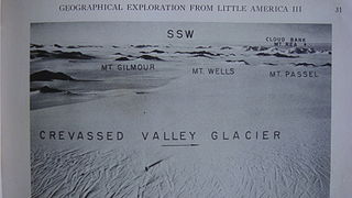
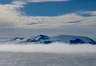
The Denfeld Mountains are a group of scattered mountains between Crevasse Valley Glacier and Arthur Glacier in the Ford Ranges of Marie Byrd Land, Antarctica.
The Phillips Mountains are a range of mountains on the north side of Balchen Glacier and Block Bay in the Ford Ranges, Marie Byrd Land, Antarctica.
The Harold Byrd Mountains are a group of exposed mountains and nunataks which extend in an east–west direction between the lower part of Leverett Glacier and the head of the Ross Ice Shelf in Antarctica. They were discovered in December 1929 by the Byrd Antarctic Expedition geological party under Laurence Gould, and named by Rear Admiral Richard E. Byrd for D. Harold Byrd, a cousin of his and a contributor towards the purchase of furs for the expedition.

Sarnoff Mountains is a range of mountains, 251 nautical miles long and 4 to 8 nautical miles wide separating the west-flowing Boyd Glacier and Arthur Glacier in the Ford Ranges of Marie Byrd Land, Antarctica.
Radford Island is an ice-covered island surmounted by several peaks, lying 6 nautical miles west of Saunders Mountain in the east part of Sulzberger Ice Shelf, Antarctica.
The Allegheny Mountains are a small group of mountains 10 nautical miles west of the Clark Mountains in the Ford Ranges of Marie Byrd Land, Antarctica.


