Scarborough Bluffs

Last updated

The Scarborough Bluffs seen from Bluffers Park. Scarborough Bluffs - Laslovarga (11).jpg
The Scarborough Bluffs seen from Bluffers Park.

The Scarborough Bluffs, also known as The Bluffs, is an escarpment in the Scarborough district of Toronto, Ontario, Canada. There are nine parks along the bluffs, with Bluffers Park being the only one with a beach. Forming much of the eastern portion of Toronto's waterfront, the Scarborough Bluffs stands above the shoreline of Lake Ontario. At its highest point, the escarpment rises 90 metres (300 ft) above the coastline and spans a length of 15 kilometres (9.3 mi).

Contents

History

The Scarborough Bluffs previously extended further along the coast of Lake Ontario, but its western fringe was leveled by explosives to make way for urban development. Scarboro Bluffs in 1909.jpg
The Scarborough Bluffs previously extended further along the coast of Lake Ontario, but its western fringe was leveled by explosives to make way for urban development.

The French gave the name "Les Grands Ecores", or tall points on the shore, to the cliffs. [1] In the 1788 Plan of Toronto by Alexander Aitken, the bluffs were simply known as the High Lands. [2] They became known as the Scarborough Highlands in 1793 named after Scarborough, North Yorkshire. This name was chosen by Elizabeth Simcoe, who was the wife of the first lieutenant governor of Upper Canada, John Graves Simcoe. The escarpment along Lake Ontario reminded Elizabeth Simcoe of the limestone cliffs in her hometown. In her diary, she wrote, "The shore is extremely bold and has the appearance of chalk cliffs, but I believe they are only white sand. They appeared so well that we talked of building a summer residence there and calling it Scarborough." [3] [4] The name was later given to the entire township in 1796. In time, the cliffs became known as the Bluffs. [1] A stylized version of The Bluffs was incorporated into the design of the official flag of the former city of Scarborough.

The Scarborough Bluffs formerly extended further west along the coastline of Lake Ontario towards the Toronto Harbour, but extensive areas along the western fringe were leveled by the use of explosives for the implementation of primarily industrial and some residential urban development. Even the existing formation has and continues to shrink considerably decade after a decade due to consistent and dramatic erosion.

The Bluffs has become a community meeting place for people of all ages. It features various recreational hiking and walking trails, as well as picnic tables, fire pits, places to pitch a tent, parking lots, a restaurant, and a large marina with a boating club.

Geology

The Bluffs run 15 kilometres (9.3 mi) from the foot of Victoria Park Avenue in the west to the mouth of Highland Creek in the east, reaching as high as 90 metres (300 ft)— the equivalent of twenty-five storeys. [5] However, the escarpment continues westward inland, running between Kingston Road and Queen Street East, pausing over the Don Valley, and continuing on the north side of Davenport Road. The escarpment forms part of the old shoreline of Glacial Lake Iroquois, formed after the last ice age, which left valuable geological records as the part of the escarpment by the lake eroded. The eroded alluvial deposits from the Bluffs then settled westward to form the Toronto Islands.

Scarborough Bluffs panorama.jpg
Panoramic view of the Scarborough Bluffs and Lake Ontario from the base.

Issues

Erosion

Erosion is a major issue in the preservation of the Scarborough Bluffs. Scarborough Bluffs 02.jpg
Erosion is a major issue in the preservation of the Scarborough Bluffs.

The Scarborough Bluffs have been eroding at a rapid rate since residences have been built along the lake bluff tops. The million-dollar views have been prime real estate since the 1940s. [6] The desire for a beautiful lakeside view and an affluent lifestyle led to a real estate boom along the Bluffs—this resulted in a direct correlation of the accelerating rate of erosion. [7] The eroding Bluffs have resulted in damaged private property and the need for public assets to be spent on repairs and corrective action. [7] In summer 2008, chunks of the Bluffs had eroded to the point that one quarter of a cottage that actor and comedian Billy Van once owned, was left hanging on the cliff—the cottage was deemed a safety hazard by Toronto city officials as a result. [6] To combat erosion, boulders acting as armour, rocks, and trees were placed at the base. However, to place these rocks and trees, a beach must be created to allow trucks to access the cliff base which would involve leveling parts of the Bluffs, such as the aforementioned Bluffer's Park. The Cathedral Bluffs, which is an impressive portion of the Bluffs, was the result of continued erosion. [6] In 2017, the Toronto and Region Conservation Authority (TRCA) created the Scarborough Waterfront Project which aims to revamp about 11 kilometres of Scarborough Bluff's shoreline which includes the expansion of the existing beach by approximately 60 metres into Lake Ontario between Bluffer's Park and Meadowcliffe. [8]

On August 23, 2020, a large portion of the Scarborough Bluffs near Lookout Point collapsed onto a beach causing "explosion-like" sounds followed by a wave of dust. A number of beachgoers were in the area but there were no reports of injuries in the collapse. [9]

Safety

The Scarborough Bluffs have been a sought out destination for photographers and visitors to trek through. However, due to erosion and flooding, this leads to dangerous conditions; according to the TRCA, numerous people ignore warning signage. Areas that appear to be stable can collapse. "In terms of the park areas or where people want to go right at the top of the Bluffs, it's completely safe as long as they stay on the appropriate side of the fence. It's when they go on the wrong side of the fence that it causes issue". [10] Currently, for those who ignore signage and enter restricted areas, fines of up to $5,000 will be handed out. [11]

Parks

View from atop the Scarborough Bluffs at Bluffers Park. The Bluffer's Park Yacht Club is visible to the left. Scarborough Bluffs - Laslovarga (33).jpg
View from atop the Scarborough Bluffs at Bluffers Park. The Bluffer's Park Yacht Club is visible to the left.

A number of city parks are located along the bluffs from Victoria Park Avenue to Rouge River. Most are located on the top the bluffs, but some are located at the base along the shoreline with Lake Ontario.

Development of parkland began with the then Borough of Scarborough prior to 1960, while some remained in private hands. The land that makes up Cathedral Bluffs Park was originally owned by Sisters of St. Joseph, who later sold it to developers; who left the area near the edge of the Bluffs as parkland. The land was later acquired by TRCA in 1960. Cudia Park and Scarborough Heights Park were parks that were acquired by Metro Toronto in 1960 from Scarborough, and later transferred to TRCA. From 1960 to 1978 the parks were acquired by the TRCA which developed into today's current parks. Sylvan Park was acquired by Metro Toronto in 1966, and later transferred to the TRCA. Rosetta McClain Gardens was another property acquired in 1959 by Metro Toronto from Robert Watson McClain. However, it did not become a park until 1977, when it was transferred to the TRCA.

Most parks do not have direct access to Lake Ontario, such as Scarboro Crescent Park. Located on Cecil Crescent and due west of Bluffer's Park, the park is located on top of bluffs with no access to the water. It was formerly known as Scarborough Bluffs Park before the municipal government renamed it as Scarboro Crescent Park, to discourage users from attempting to climb down from the location. [12] One of the only park along the Bluffs that has direct access to the lake is Bluffer's Park. It features a sandy beach and man-made berms that provide views of both the bluffs and the lake; land was acquired by TRCA from Borough of Scarborough in 1960 and opened as a park in 1975. Port Union Waterfront Park is another park that features breakwaters to protect its shoreline. Breakwaters are also found between Sylvan and Cudia Park. Berms and infill were also added to create waterfront area at East Point Park.

Municipal parks on the Scarborough Bluffs includes:

Communities

There are two registered non-profit community associations in the Scarborough Bluffs area

See also

Related Research Articles

Scarborough or Scarboro may refer to:

<span class="mw-page-title-main">Niagara Escarpment</span> Escarpment in Canada and the United States

The Niagara Escarpment is a long escarpment, or cuesta, in Canada and the United States that starts from the south shore of Lake Ontario westward, circumscribes the top of the Great Lakes Basin running from New York through Ontario, Michigan, and Wisconsin. The escarpment is the cliff over which the Niagara River plunges at Niagara Falls, for which it is named.

<span class="mw-page-title-main">Escarpment</span> Steep slope or cliff separating two relatively level regions

An escarpment is a steep slope or long cliff that forms as a result of faulting or erosion and separates two relatively level areas having different elevations.

<span class="mw-page-title-main">Scarborough, Ontario</span> District of Toronto, Ontario, Canada

Scarborough is a district of Toronto, Ontario, Canada. It is situated atop the Scarborough Bluffs in the eastern part of the city. Its borders are Victoria Park Avenue to the west, Steeles Avenue and the city of Markham to the north, Rouge River and the city of Pickering to the east, and Lake Ontario to the south. Scarborough was named after the English town of Scarborough, North Yorkshire, inspired by its cliffs.

<span class="mw-page-title-main">Don River (Ontario)</span> River in Canada

The Don River is a watercourse in southern Ontario that empties into Lake Ontario, at Toronto Harbour. Its mouth was just east of the street grid of the town of York, Upper Canada, the municipality that evolved into Toronto, Ontario. The Don is one of the major watercourses draining Toronto that have headwaters in the Oak Ridges Moraine.

<span class="mw-page-title-main">The Beaches, Toronto</span> Neighbourhood in Toronto, Ontario, Canada

The Beaches is a neighbourhood in Toronto, Ontario, Canada. It is so named because of its four beaches situated on Lake Ontario. It is located east of downtown within the "Old" City of Toronto. The approximate boundaries of the neighbourhood are from Victoria Park Avenue on the east to Kingston Road on the north, along Dundas Street to Coxwell Avenue on the west, south to Lake Ontario. The Beaches is part of the east-central district of Toronto.

<span class="mw-page-title-main">Toronto waterfront</span> Shore of Lake Ontario in Toronto, Canada

The Toronto waterfront is the lakeshore of Lake Ontario in the city of Toronto, Ontario, Canada. It spans 46 kilometres between the mouth of Etobicoke Creek in the west and the Rouge River in the east.

<span class="mw-page-title-main">Cliffside, Toronto</span> Neighbourhood in Toronto, Ontario, Canada

Cliffside is a neighbourhood in Toronto, Ontario, Canada, located along the Scarborough Bluffs in the district of Scarborough. Its boundaries are Kennedy Road to the west, St. Clair Avenue East to the north, Brimley Road to the east, and the Bluffs on the lakeshore to the south.

<span class="mw-page-title-main">Guildwood</span> Neighbourhood in Toronto, Ontario, Canada

Guildwood, also known as Guildwood Village, is a residential neighbourhood in Toronto, Ontario, Canada. It is located in the eastern area of the city, in the district of Scarborough. It is bounded by the Scarborough Bluffs, south of Kingston Road, from Grey Abbey Trail in the east.

<span class="mw-page-title-main">Toronto Harbour</span> Bay on the north shore of Lake Ontario, in Toronto, Ontario, Canada

Toronto Harbour or Toronto Bay is a bay on the north shore of Lake Ontario, in Toronto, Ontario, Canada. It is a natural harbour, protected from Lake Ontario waves by the Toronto Islands. Today, the harbour is used primarily for recreational boating, including personal vessels and pleasure boats providing scenic or party cruises. Ferries travel from docks on the mainland to the Islands, and cargo ships deliver aggregates and raw sugar to industries located in the harbour. Historically, the harbour has been used for military vessels, passenger traffic and cargo traffic. Waterfront uses include residential, recreational, cultural, commercial and industrial sites.

<span class="mw-page-title-main">Leslie Street Spit</span> Human-made headland in Ontario, Canada

The Leslie Street Spit, or officially the Outer Harbour East Headland, is a human-made headland in Toronto, Ontario, Canada, extending from the city's east end in a roughly southwesterly direction into Lake Ontario. It is about 5 kilometres (3 mi) long. The Spit is the result of five decades of lakefilling by the Toronto Port Authority. It was conceived as an extension of Toronto Harbour, and has evolved into a largely passive recreation area. Naturalization had not been planned but the process is now actively managed by the Toronto and Region Conservation Authority. A large portion of it is classified as an Environmentally Sensitive Area (ESA) and it is recognized as an Important Bird Area.

The Toronto and Region Conservation Authority (TRCA) is a conservation authority in southern Ontario, Canada. It owns about 16,000 hectares of land in the Toronto region, and it employs more than 400 full-time employees and coordinates more than 3,000 volunteers each year. TRCA's area of jurisdiction is watershed-based and includes 3,467 square kilometres (1,339 sq mi) – 2,506 on land and 961 water-based in Lake Ontario. This area comprises nine watersheds from west to east – Etobicoke Creek, Mimico Creek, Humber River, Don River, Highland Creek, Petticoat Creek, Rouge River, Duffins Creek and Carruthers Creek.

<span class="mw-page-title-main">Guild Inn</span> Artist colony and hotel in Toronto, Canada

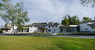
The Guild Inn, or simply The Guild was a historic hotel in the Guildwood neighbourhood of Scarborough, Toronto, Ontario and was once an artists colony. The surrounding Guild Park and Gardens is notable for a sculpture garden consisting of the rescued facades and ruins of various demolished downtown Toronto buildings such as bank buildings, the old Toronto Star building and the Granite Club. The park is situated on the Scarborough Bluffs with views of Lake Ontario. Guild Park remained open and the refurbishment of the Guild Inn into a facility for social events was completed in May 2017.

<span class="mw-page-title-main">Toronto and Scarboro' Electric Railway, Light and Power Company</span>

Toronto and Scarboro' Electric Railway, Light and Power Company was established in August 1892 to provide street railway service to the Upper Beaches district within the City of Toronto, Ontario and to the neighbouring Township of Scarborough. Except for two branches, the line ran as a radial along Kingston Road.

<span class="mw-page-title-main">Humber Bay</span>

Humber Bay is a bay of Lake Ontario south of Toronto, Ontario, Canada. It is located between Ontario Place on the east and Mimico Creek to the west. The bay gives its name to Etobicoke's Humber Bay neighbourhood.

<span class="mw-page-title-main">Cliffcrest</span> Neighbourhood in Toronto, Ontario, Canada

Cliffcrest is a residential neighborhood in Toronto, Ontario, Canada. It is located along the shores of Lake Ontario in the district of Scarborough, bordered by Midland Avenue to the west, the Canadian National Railway to the north, and Bellamy Road to the east.

<span class="mw-page-title-main">Birch Cliff</span> Neighbourhood in Toronto, Ontario, Canada

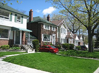
Birch Cliff is a neighbourhood in Toronto, Ontario, Canada. It is located in the eastern part of the city, part of the district of Scarborough running along the shore of Lake Ontario atop the western part of the Scarborough Bluffs. Birch Cliff has a large Irish population. About one-third of Birch Cliff residents are of Irish origin.

<span class="mw-page-title-main">Osterhout Log Cabin</span> Building

The Osterhout Log Cabin is a log cabin located within Guild Park and Gardens, Guildwood, Scarborough, Toronto, Ontario, Canada. Situated along the Scarborough Bluffs, the cabin is one of the oldest remaining buildings in Scarborough, Toronto.

<span class="mw-page-title-main">Guild Park and Gardens</span> Public park and building stonework conservatory in Toronto, Canada

Guild Park and Gardens is a public park in the Scarborough district of Toronto, Ontario, Canada. The park was formerly the site of an artist colony and is notable for its collection of relics saved from the demolition of buildings primarily in downtown Toronto arranged akin to ancient ruins. Located on the Scarborough Bluffs, Guild Park and Gardens has an outdoor Greek stage and a 19th-century log cabin among the oldest in Toronto. The principal building in the park is the Guild Inn, a former inn and estate mansion.

References

Citations
  1. 1 2 Fairburn 2013.
  2. Hayes 2008, p. 16.
  3. Carter, Chris (October 6, 2005). "A holiday with history". toronto.com. Archived from the original on April 10, 2010. Retrieved September 23, 2007.
  4. "The Trip to York". Travels with Elizabeth Simcoe. Archives of Ontario. Archived from the original on August 2, 2007. Retrieved September 23, 2007.
  5. "Scarborough Bluffs". Stay.com.
  6. 1 2 3 "Scarborough Bluffs residents left hanging". thestar.com. August 22, 2008.
  7. 1 2 Eyles, N., et al. "Applied Sedimentology in an Urban Environment—the Case of Scarborough Bluffs, Ontario: Canada's Most Intractable Erosion Problem." Geoscience Canada 12.3 (1985).
  8. "Getting to Know the Scarborough Waterfront Project - The West Segment". Toronto and Region Conservation. July 7, 2017.
  9. Part of Scarborough Bluffs near lookout point collapses onto beach, Global News Toronto , August 24, 2020
  10. O'Keefe, Lara. "They're not bluffing. TRCA says heed the warning signs at Scarborough Bluffs or get a fine—Beach Metro Community News." Beach Metro Community News, 21 June 2017, www.beachmetro.com/2017/06/21/theyre-not-bluffing-trca-says-heed-warning-signs-scarborough-bluffs-get-fine/.
  11. O'Keefe, Lara. "They're not bluffing. TRCA says heed the warning signs at Scarborough Bluffs or get a fine—Beach Metro Community News." Beach Metro Community News, 21 June 2017, www.beachmetro.com/2017/06/21/theyre-not-bluffing-trca-says-heed-warning-signs-scarborough-bluffs-get-fine/.
  12. Fox, Chris (May 2, 2017). "Scarborough Bluffs Park renamed to avoid confusion with nearby beach". cp24.com.
  13. "Scarborough Bluffs Community Association". ScarboroughBluffs.ca.
  14. "Guildwood Village Community Association". guildwood.on.ca.
Bibliography

43°42′07″N79°14′31″W / 43.702°N 79.242°W / 43.702; -79.242