Toronto is the capital of Ontario and the largest city in Canada.

The National Flag of Canada, often referred to simply as the Canadian flag, consists of a red field with a white square at its centre in the ratio of 1∶2∶1, in which is featured one stylized, red, 11-pointed maple leaf charged in the centre. It is the first flag to have been adopted by both houses of Parliament and officially proclaimed by the Canadian monarch as the country's official national flag. The flag has become the predominant and most recognizable national symbol of Canada.
The phrase Common Sense Revolution (CSR) has been used as a political slogan to describe conservative platforms with a main goal of reducing taxes while balancing the budget by reducing the size and role of government. It has been used in places such as Australia and Canada. This article deals with the "Common Sense Revolution" as it was under Ontario Premier Mike Harris and the Progressive Conservative Party of Ontario from 1995 to 2002.
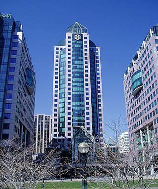
The Municipality of Metropolitan Toronto was an upper-tier level of municipal government in Ontario, Canada, from 1953 to 1998. It was made up of the old city of Toronto and numerous townships, towns and villages that surrounded Toronto, which were starting to urbanize rapidly after World War II. It was commonly referred to as "Metro Toronto" or "Metro".
A regional municipality is a type of Canadian municipal government similar to and at the same municipal government level as a county, although the specific structure and servicing responsibilities may vary from place to place. Regional municipalities were formed in highly populated areas where it was considered more efficient to provide certain services, such as water, emergency services, and waste management over an area encompassing more than one local municipality. For this reason, regions may be involved in providing services to residents and businesses.

The Toronto City Hall, or New City Hall, is the seat of the municipal government of Toronto, Ontario, Canada, and one of the city's most distinctive landmarks. Designed by Viljo Revell and engineered by Hannskarl Bandel, the building opened in 1965. The building is located adjacent to Nathan Phillips Square, a public square at the northwest intersection of Bay Street and Queen Street, that was designed and officially opened alongside Toronto City Hall.
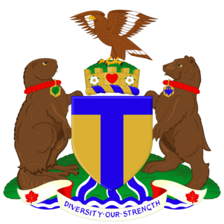
The coat of arms of Toronto is a heraldic symbol used to represent the city Toronto. Designed by Robert Watt, the Chief Herald of Canada at the time, for the City of Toronto after its amalgamation in 1998. The arms were granted by the Canadian Heraldic Authority on 11 January 1999.

The Regional Municipality of Hamilton–Wentworth was an upper-tier regional municipality in Ontario, Canada, that existed between January 1, 1974, and January 1, 2001. It was composed of six municipalities, centered on and including the City of Hamilton, and existed to coordinate certain shared services, such as policing and public transit, for those municipalities. It was created through the restructuring of Wentworth County, and was one of the last such governments to be created in Ontario.

The Regional Municipality of Ottawa–Carleton was a Regional Municipality and Census Division in Ontario, Canada, that existed between January 1, 1969, and January 1, 2001, and was primarily centred on the City of Ottawa. It was created in 1969 by restructuring Carleton County and annexing Cumberland Township from the United Counties of Prescott and Russell into the newly created Region of Ottawa–Carleton.
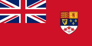
The Canadian Red Ensign served as a nautical flag and civil ensign for Canada from 1892 to 1965, and later as the de facto flag of Canada before 1965. The flag is a British Red Ensign, with the Royal Union Flag in the canton, emblazoned with the shield of the coat of arms of Canada.

The official flag of Scarborough consisted of a stylized abstract impression of the Scarborough Bluffs and Lake Ontario in blue on the left and bottom of the flag. The background is white, with the red Maple Leaf of the Flag of Canada near the centre of the otherwise void area.

The Great Canadian flag debate was a national debate that took place in 1963 and 1964 when a new design for the national flag of Canada was chosen.

Lieutenant-Commander Alan Brookman Beddoe, OC, OBE, HFHS, FHSC was a Canadian artist, war artist, consultant in heraldry and founder and first president of the Heraldry Society of Canada in 1965.

The Hamilton Police Service (HPS) is the police service of the city of Hamilton, Ontario, Canada. As of 2021, the service employed 829 sworn officers and 414 non-sworn staff, serving a population of about 570 000 residents. The service's headquarters are located at 155 King William St., Hamilton, Ontario. As of 2022, the service's budget is $183 542 539, roughly 18.5% of the City's overall budget. It is one of the oldest police forces in Ontario.

Old Toronto is the part of Toronto, Ontario, Canada, that corresponds to the boundaries of the City of Toronto prior to 1998. It was incorporated as a city in 1834, after being known as the town of York, and being part of York County. Toronto periodically grew in size by annexing adjacent land and municipalities.
Local government in Canada can be defined as all elected local authorities which are legally empowered to make decisions on behalf of its electors, excluding the federal government, provincial and territorial governments, and First Nations, Métis and Inuit governments. This can include municipalities, school boards, health authorities, and so on.

The amalgamation of Toronto was the creation of the city limits of Toronto, Ontario, Canada after amalgamating, annexing, and merging with surrounding municipalities since the 18th century. The most recent occurrence of amalgamation was in 1998, which dissolved the federation of Metropolitan Toronto and its constituent municipalities, and created the current "megacity" of Toronto.
The following outline is provided as an overview of and topical guide to Toronto:
