Rouge River (Ontario)

Last updated

Rouge River
Finch Meandor with Rouge River.jpg
The Rouge River and Valley viewed from the Finch Meander Trail
Toronto map.svg
Red pog.svg
Location of the mouth of the Rouge River in Toronto
Native nameGichi-ziibiins (Ojibwe)
Location
Country Canada
Province Ontario
Region Greater Toronto Area
Municipalities
Physical characteristics
Source 
  location Richmond Hill
  coordinates 43°56′33″N79°25′05″W / 43.94250°N 79.41806°W / 43.94250; -79.41806
  elevation306 m (1,004 ft)
Mouth Lake Ontario
  location
West Rouge, Toronto
  coordinates
43°47′41″N79°06′55″W / 43.79472°N 79.11528°W / 43.79472; -79.11528
  elevation
74 m (243 ft)
Basin size336 km2 (130 sq mi)
Discharge 
  average1.76 m3/s (62 cu ft/s)
  minimum0.45 m3/s (16 cu ft/s)
  maximum5.98 m3/s (211 cu ft/s)
Basin features
River system Great Lakes Basin
Tributaries 
  leftLittle Rouge River
  rightLittle Rouge Creek, Katabokokonk Creek, Bruce Creek, Beaver Creek

The Rouge River is a river in Markham, Pickering, Richmond Hill and Toronto in the Greater Toronto Area of Ontario, Canada. [1] The river flows from the Oak Ridges Moraine to Lake Ontario at the eastern border of Toronto, and is the location of Rouge Park, [2] the only national park in Canada within a municipality. At its southern end, the Rouge River is the boundary between Toronto and southwestern Pickering in the Regional Municipality of Durham.

Contents

History

The Rouge River is part of the Carolinian life zone that is found in Southern Ontario. After the eradication of both the Petun and the Wyandot (Huron), Senecas from New York attempted to establish/expand their fur trade activities by establishing a village named Gandechiagaiagon (recorded variously as "Gandatsekiagon", "Ganatsekwyagon", "Gandatchekiagon", or "Katabokokonk"), meaning "sand-cut" at the mouth of Rouge River. [3] According to a 1796 list by English surveyor Augustus Jones, the Mississauga name for the river was Gichi-ziibiins (recorded as "Che-sippi"), meaning "large creek." [4] The river's name likely is French for "red river", based on the mappings by French explorer Louis Jolliet.

In the early 19th century, pioneer settlers could spear large salmon spawning as far north as the upper tributaries of the Rouge in what is today Whitchurch-Stouffville [5]

In the former City of Scarborough, the Rouge was the "third rail" issue of municipal politics, and many minor candidates for mayor often ran on a platform to preserve it. However, since Scarborough was annexed into the City of Toronto, Toronto City Council has voted on occasion to allow development around the river. For much of the course of the system in Toronto is still parkland or farmland.

As for the York Region sections, the southern watershed runs through residential areas and is lined with a few small parks. The source of the system is either natural or farmland.

Currently, there is a degree of abandonment in the area, of former farmlands, and historic houses. There also remain many historic houses which are still lived in, some even farmed. Research on Toronto's website listing its holdings of historic properties reveals over 20 historic buildings in the area, including Hillside PS, Scarborough's first schoolhouse, which sits across the street from a house built by the Pearse family in 1855.

Geography

Watershed

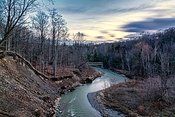
The Rouge River begins in the Oak Ridges Moraine in Richmond Hill and flows past: Markham, northwest, central, to the south, including a couple of conservation areas, the eastern edge of Scarborough and Rouge Valley Park. The watershed of the Rouge River is located in the municipalities of Richmond Hill and Markham in the Regional Municipality of York; Pickering in the Regional Municipality of Durham; and Toronto.

Lower course of the Rouge River, circa 1932 Lower course of the Rouge River, circa 1932.jpg
Lower course of the Rouge River, circa 1932
Marshes located near the estuary Rouge River Marshes.jpg
Marshes located near the estuary

Tributaries of the Rouge River also extend into the municipalities of Aurora and Whitchurch-Stouffville in the Regional Municipality of York. The total area of the watershed is 336 square kilometres (130 sq mi), of which 40% is agricultural land, 35% urban, 24% forest/wetland/meadow and 1% watercourses/waterbodies. [6]

The headwaters of the Rouge River and its tributaries are found in the Oak Ridges Moraine. Water flows down from the elevated moraine to Lake Ontario.

The estuary of the Rouge River Estuary of the Rouge.jpg
The estuary of the Rouge River

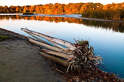
The Rouge River meets Lake Ontario at Rouge Beach. At Rouge Beach, the Rouge Marsh is to the north and Lake Ontario to the south. More than half the remaining wetlands in the Greater Toronto Area are located here in the southern Rouge River.

It is one of a few wilderness areas left in South-Central Ontario and has been virtually untouched by development since the arrival of Europeans. While many exclusive homes and conclaves border this area on the southern tip, it is currently surrounded largely by agricultural land. It is even devoid of recreational development but sports a considerable network of walking or bicycle paths. Unlike other rivers in the Toronto area, it is allowed to fill its entire flood plain on a regular basis rather than being forced through an artificial channel. However, parts of its watershed include the Toronto Zoo and the Beare Road Landfill.

Tributaries

Little Rouge River is a tributary of the Rouge, that runs northeast to Bloomington. Little Rouge River Banks.jpg
Little Rouge River is a tributary of the Rouge, that runs northeast to Bloomington.

Parks

View of Rouge Pond from Rouge National Urban Park. The pond is located at the mouth of the river. Pond at south end of Rouge 1.jpg
View of Rouge Pond from Rouge National Urban Park. The pond is located at the mouth of the river.

National Park

Rouge National Urban Park is a national urban park managed by Parks Canada. The Park the largest urban park in North America, comprising a significant portion of the Rouge River. The Park was created after the Ministry of Stephen Harper proposed, in the 41st Canadian Parliament throne speech, the creation of the national park. [7]

Municipal parks

The Milne-Dam Conservation Park is one of several municipal parks that lie within the river's watershed. MilneDamConservationPark3.jpg
The Milne-Dam Conservation Park is one of several municipal parks that lie within the river's watershed.
The Rouge Beach park during rain, located at the estuary of the Rouge River Rouge Beach Park.jpg
The Rouge Beach park during rain, located at the estuary of the Rouge River

There are a number of local parks around of the Rouge watershed managed by the municipalities of Markham, Pickering, Richmond Hill, and Toronto. In addition, the Toronto and Region Conservation Authority manages a number of parks and conservation areas. These parks include:

  • Bob Hunter Memorial Park
  • Littles Road Park
  • Morningview Ravine Park
  • Woodlands Park
  • Glen Rouge Park
  • Rouge Valley Park, Markham
  • Rouge Beach Park
  • Milne Park, Markham
  • Apple Creek Park
  • Cedar Valley Park
  • Mount Joy Lake Park
  • Springdale Park
  • Monarch Park
  • Ashton Meadows Park
  • Artisan Park - Beaver Creek
  • Beaver Greenway - Beaver Creek
  • Bruce Creek Park
  • Berczy Creek Park
  • Boyton Woods Park
  • Elgin Mills Cemetery
  • Headwaters Park

Metro East Freeway

The Rouge was threatened by the proposed Metro East Freeway which would have run along the river valley like the Don Valley Parkway from north Scarborough through Markham between Ninth Line and York-Durham Town Line terminating in Stouffville. The roadway came into existence following the cancellation of the Spadina Expressway and pause on Scarborough Expressway in 1971. It was removed from planning in 1994. Markham continues to seek an arterial connection to Ontario Highway 401 which led to the construction of Donald Cousens Parkway with planned connection to Highway 401 via extension of Morningside Avenue to Steeles Avenue.

Golf courses

A 18-hole golf course, Unionville Golf Centre, operated from 1961 to 2007 on Main Street Unionville south of Highway 7 along the Rouge River. [8] It is now site of Bill Crothers Secondary School. The golf greens area along the river have now been restored as natural habitat.

See also

Related Research Articles

<span class="mw-page-title-main">Markham, Ontario</span> City in Ontario, Canada

Markham is a city in the Regional Municipality of York, Ontario, Canada. It is approximately 30 km (19 mi) northeast of Downtown Toronto. In the 2021 Census, Markham had a population of 338,503, which ranked it the largest in York Region, fourth largest in the Greater Toronto Area (GTA), and 16th largest in Canada.

<span class="mw-page-title-main">Regional Municipality of York</span> Regional municipality in Ontario, Canada

The Regional Municipality of York, also called York Region, is a regional municipality in Southern Ontario, Canada, between Lake Simcoe and Toronto. The region was established after the passing of then Bill 102, An Act to Establish The Regional Municipality of York, in 1970. It replaced the former York County in 1971, and is part of the Greater Toronto Area and the inner ring of the Golden Horseshoe. The regional government is headquartered in Newmarket.

<span class="mw-page-title-main">Scarborough, Ontario</span> District of Toronto, Ontario, Canada

Scarborough is a district of Toronto, Ontario, Canada. It is situated atop the Scarborough Bluffs in the eastern part of the city. Its borders are Victoria Park Avenue to the west, Steeles Avenue and the city of Markham to the north, Rouge River and the city of Pickering to the east, and Lake Ontario to the south. Scarborough was named after the English town of Scarborough, North Yorkshire, inspired by its cliffs.

<span class="mw-page-title-main">Humber River (Ontario)</span> River in Canada

The Humber River is a river in Southern Ontario, Canada. It is in the Great Lakes Basin, is a tributary of Lake Ontario and is one of two major rivers on either side of the city of Toronto, the other being the Don River to the east. It was designated a Canadian Heritage River on September 24, 1999.

<span class="mw-page-title-main">Whitchurch-Stouffville</span> Town in Ontario, Canada

Whitchurch-Stouffville is a town in the Greater Toronto Area of Ontario, Canada, approximately 50 km (31 mi) north of downtown Toronto, and 55 km (34 mi) north-east of Toronto Pearson International Airport. It is 206.22 km2 (79.62 sq mi) in area, and located in the mid-eastern area of the Regional Municipality of York on the ecologically-sensitive Oak Ridges Moraine. Its motto since 1993 is "country close to the city".

Stouffville is the primary urban area within the town of Whitchurch-Stouffville in York Region, Ontario, Canada. It is situated within the Greater Toronto Area and the inner ring of the Golden Horseshoe. The urban area is centred at the intersection of Main Street, Mill Street, and Market Street. Between 2006 and 2011, the population of the Community of Stouffville grew 100.5% from 12,411 to 24,886, or from 51% to 66% of the total population of the larger town of Whitchurch-Stouffville. The population of Stouffville from the 2021 census is 36,753.

<span class="mw-page-title-main">German Mills Creek</span> River in Ontario, Canada

German Mills Creek is a river in the municipalities of Markham, Richmond Hill, Toronto and Vaughan in the Greater Toronto Area of Ontario, Canada. It is part of the Great Lakes Basin and is a left tributary of the East Branch Don River. It originates in Vaughan, flows south through Richmond Hill and Markham, and empties into the East Branch Don River in the East Don Parklands in Toronto, south of Steeles Avenue between Bayview Avenue and Leslie Street. It is part of a number of streams, swamps and swales located near the Oak Ridges Moraine. The creek's approximate length is 10 kilometres (6 mi).

Buttonville is a suburban planned neighbourhood from a former police village in the city of Markham, Ontario, Canada, west of the larger Unionville neighbourhood. the former hamlet and police village named after its founder, John Button.

<span class="mw-page-title-main">Unionville, Ontario</span> Suburban district in York, Ontario, Canada

Unionville is a suburban district and former village in Markham, Ontario, Canada, 2 km (2.5 mi) west of Markham Village, and 33 km (20.5 mi) northeast of Downtown Toronto. The boundaries of Unionville are not well-defined. Several neighbourhoods claim to be part of it however, this has been disputed between the various wards.

<span class="mw-page-title-main">Centennial GO Station</span> Railway station in Markham, Ontario, Canada

Centennial GO Station is a train station on the GO Transit Stouffville line in Markham, Ontario, Canada. The station is located directly west of McCowan Road and north of Bullock Drive, near the Markham Centennial Park.

<span class="mw-page-title-main">History of Markham, Ontario</span>

The history of Markham, Ontario dates back several millennia. What would become Markham, Ontario was home to First Nations long before European settlement. Seasonal settlements were found from 900 BC to 1650, but traces of these first residence were buried before the area was farmed.

The Toronto and Region Conservation Authority (TRCA) is a conservation authority in southern Ontario, Canada. It owns about 16,000 hectares of land in the Toronto region, and it employs more than 400 full-time employees and coordinates more than 3,000 volunteers each year. TRCA's area of jurisdiction is watershed-based and includes 3,467 square kilometres (1,339 sq mi) – 2,506 on land and 961 water-based in Lake Ontario. This area comprises nine watersheds from west to east – Etobicoke Creek, Mimico Creek, Humber River, Don River, Highland Creek, Petticoat Creek, Rouge River, Duffins Creek and Carruthers Creek.

<span class="mw-page-title-main">Rouge National Urban Park</span> National urban park in Ontario, Canada

Rouge National Urban Park is a national urban park in Ontario, Canada. The park is centred around the Rouge River and its tributaries in the Greater Toronto Area. The southern portion of the park is situated around the mouth of the river in Toronto, and extends northwards into Markham, Pickering, Uxbridge, and Whitchurch-Stouffville.

<span class="mw-page-title-main">Highland Creek (Toronto)</span> River in Ontario, Canada

Highland Creek is a river in the Scarborough district of Toronto, Ontario, emptying into Lake Ontario at the eastern end of the Scarborough Bluffs. It is home to several species of fish including trout, carp, bass and salmon. It is a meandering river which, like most rivers in Toronto, travels through a glacial ravine formed after the last Ice Age. The Highland Creek watershed, including tributaries, is almost entirely contained within Scarborough.

West Highland Creek is a river in Toronto, Ontario, Canada, and is a tributary of Highland Creek in the Lake Ontario drainage basin. The creek and its tributaries are entirely within the old City of Scarborough, and provide the watershed for the northwest of the city.

<span class="mw-page-title-main">Ringwood, Ontario</span> Unincorporated community in Ontario, Canada

Ringwood is a hamlet in York Region, Ontario, Canada, in the Town of Whitchurch–Stouffville. The hamlet is centred at the intersection of Stouffville Road and Highway 48, on the Little Rouge River, a tributary of the Rouge River on the Oak Ridges Moraine. The community originally straddled the townships of Markham and Whitchurch in the County of York. The hamlet was named Ringwood in 1856 by George Sylvester, postmaster and owner of a general store, after the town of Ringwood, in Hampshire, England. It was first settled in the 1790s by George Fockler from Pennsylvania. The Little Rouge River runs along the eastern edge of the hamlet. In 1857, Ringwood had a population of 200 which grew only slightly to 225 by 1910. By 1972, the population had dropped to 172. Between 2008 and 2010, more than 250 homes were constructed in Ringwood's Cardinal Point subdivision north of Main Street. Construction on a new auto mall in Ringwood began in 2009, with Hyundai and Toyota dealerships opening in 2010, and Dodge/Jeep and Nissan dealerships constructed in 2013.

Old Bailey Bridge is a Bailey bridge located below 16th Avenue east of Reesor Road within Rouge Park in Markham, Ontario, Canada. The bridge crossed the Little Rouge Creek, a tributary of the Rouge River. A new bridge was built above this bridge to provide two way access for 16th Avenue east of Ressor Road. The old bridge is in situ with ends fenced off to prevent trespassing.

<span class="mw-page-title-main">Toronto waterway system</span>

The Toronto waterway system comprises a series of natural and man-made watercourses in the Canadian city of Toronto. The city is dominated by a large river system spanning most of the city including the Don River, Etobicoke Creek, Highland Creek, Humber River, Mimico Creek and Rouge River.

<span class="mw-page-title-main">Duffins Creek</span> River in Ontario, Canada

Duffins Creek is a waterway in the eastern end of the Greater Toronto Area in Ontario, Canada. The watershed of the Duffins Creek is part of the Durham Region and the York Region.

References

  1. "Rouge River". Geographical Names Data Base . Natural Resources Canada . Retrieved August 4, 2012.
  2. Rouge River Watershed - General Map (PDF) (Map). Toronto and Region Conservation Authority. October 2006. Archived from the original (PDF) on October 3, 2012. Retrieved August 3, 2012.
  3. Macaraig, John Marvin Rodriguera (2013), Urban Greenspace, Civil Society and Science: The Creation and Management of the Rouge Park, Ontario, Canada. (Doctor of Philosophy thesis) (PDF), Toronto: University of Toronto, p. 89, retrieved May 22, 2018
  4. Fairburn, M. Jane (2013). Along the Shore: Rediscovering Toronto's Waterfront Heritage. Toronto, Ontario, Canada: ECW Press. ISBN   9781770410992.
  5. Boyle, David (1902). "On the paganism of the Iroquois of Ontario". Annual Archaeological Report 1901 - Appendix to the Report of the Minister of Education Ontario. Toronto: L.K. Cameron. p. 47.
  6. "Rouge River Watershed Features". Toronto and Region Conservation Authority. Retrieved August 3, 2012.
  7. "Rouge Valley to become national park". CBC.ca. June 3, 2011. Retrieved June 3, 2011.
  8. Pugh, Denis (March 28, 2011). "Unionville Golf Centre Inc | Unionville Golf Centre Inc Golf Course". Golflink.com. Retrieved October 31, 2012.