
Markham is a city in the Regional Municipality of York in Southern Ontario, Canada. It is approximately 30 km (19 mi) northeast of Downtown Toronto. In the 2016 Census, Markham had a population of 328,940, which ranked it the largest in York Region, fourth largest in the Greater Toronto Area (GTA), and 16th largest in Canada.

Richmond Hill is a city in south-central York Region, Ontario, Canada. Part of the Greater Toronto Area, it is the York Region's third most populous municipality and the 28th most populous municipality in Canada.

The Regional Municipality of York, also called York Region, is a regional municipality in Southern Ontario, Canada, between Lake Simcoe and Toronto. It replaced the former York County in 1971, and is part of the Greater Toronto Area and the inner ring of the Golden Horseshoe. The regional government is headquartered in Newmarket.

Yonge Street is a major arterial route in the Canadian province of Ontario connecting the shores of Lake Ontario in Toronto to Lake Simcoe, a gateway to the Upper Great Lakes. Until 1999, the Guinness Book of World Records repeated the popular misconception it was 1,896 km (1,178 mi) long, making it the longest street in the world; this was due to a conflation of Yonge Street with the rest of Ontario's Highway 11. Yonge Street is only 56 kilometres (35 mi) long.

Scarborough is an administrative division of Toronto, Ontario, Canada. Situated atop the Scarborough Bluffs, it occupies the eastern part of the city. Scarborough is contained within the borders of Victoria Park Avenue on the west, Steeles Avenue to the north, Rouge River and the city of Pickering to the east, and Lake Ontario to the south. It borders Old Toronto, East York and North York in the west and the city of Markham in the north. Scarborough was named after the English town of Scarborough, North Yorkshire.

The Humber River is a river in Southern Ontario, Canada. It is in the Great Lakes Basin, is a tributary of Lake Ontario and is one of two major rivers on either side of the city of Toronto, the other being the Don River to the east. It was designated a Canadian Heritage River on September 24, 1999.

The Rouge River is a river in Markham, Pickering, Richmond Hill and Toronto in the Greater Toronto Area of Ontario, Canada. The river flows from the Oak Ridges Moraine to Lake Ontario at the eastern border of Toronto, and is the location of Rouge Park, the only national park in Canada within a municipality. At its southern end, the Rouge River is the boundary between Toronto and southwestern Pickering in the Regional Municipality of Durham.

The Crowe River is a river in the counties of Haliburton, Hastings, Northumberland and Peterborough in southern Ontario, Canada. It is in the Lake Ontario drainage basin and is a tributary of the Trent River.

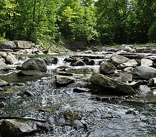
German Mills Creek is a river in the municipalities of Markham, Richmond Hill, Toronto and Vaughan in the Greater Toronto Area of Ontario, Canada. It is part of the Great Lakes Basin and is a left tributary of the East Branch Don River. It originates in Vaughan, flows south through Richmond Hill and Markham, and empties into the East Branch Don River in the East Don Parklands in Toronto, south of Steeles Avenue between Bayview Avenue and Leslie Street. It is part of a number of streams, swamps and swales located near the Oak Ridges Moraine. The creek's approximate length is 10 kilometres (6 mi).
Morningside Avenue is a suburban arterial road in Toronto, Ontario, Canada. It is entirely within Scarborough, running north by north-west from the Scarborough Bluffs overlooking Lake Ontario to the eastern terminus of McNicoll Avenue near the Rouge River valley.

Black Creek is a river in the Golden Horseshoe region of Ontario, Canada. It flows from the city of Vaughan in the Regional Municipality of York to the Humber River in Toronto. Black Creek is smaller than most of the waterways in the Greater Toronto Area.
Rouge is a neighbourhood in the northeastern area of Toronto, Ontario, within the former city of Scarborough. It is Toronto's largest neighbourhood by surface area; however, unlike other neighbourhoods, most of its area remains undeveloped, as the neighbourhood is adjacent to Rouge National Urban Park.

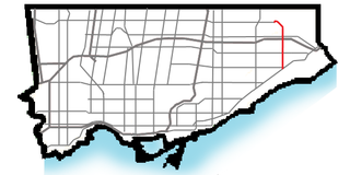
Donald Cousens Parkway or York Regional Road 48, also referred to historically as the Markham Bypass or Markham Bypass Extension, is a regionally maintained arterial bypass of Markham in the Canadian province of Ontario. Named for former Markham mayor Don Cousens in April 2007, the route initially travelled northward from Copper Creek Drive in Box Grove, south of Highway 407, to Major Mackenzie Drive. A southern extension to Steeles Avenue was later completed and the name Donald Cousens Parkway applied along the extension to Ninth Line. In addition to its role of funneling through-traffic around downtown Markham, the route serves as a boundary to residential development as land to the north and east are part of the protected Rouge National Urban Park and southwest limits of the planned Pickering Airport.

Highland Creek is a river in the Scarborough district of Toronto, Ontario, emptying into Lake Ontario at the eastern end of the Scarborough Bluffs. It is home to several species of fish including trout, carp, bass and salmon. It is a meandering river which, like most rivers in Toronto, travels through a glacial ravine formed after the last Ice Age. The Highland Creek watershed, including tributaries, is almost entirely contained within Scarborough.
West Highland Creek is a river in Toronto, Ontario, Canada, a tributary of Highland Creek in the Lake Ontario drainage basin. The creek and its tributaries are entirely within the old City of Scarborough, and it provides the watershed for the northwest of the city.
Little Etobicoke Creek is a small river in Mississauga, Regional Municipality of Peel in the Greater Toronto Area of Ontario, Canada. It is in the Great Lakes Basin and is a right tributary of Etobicoke Creek, which flows to Lake Ontario.
Old Bailey Bridge is a bailey bridge located below 16th Avenue east of Reesor Road within Rouge Park in Markham, Ontario, Canada. The bridge crossed the Little Rouge Creek, a tributary of the Rouge River. A new bridge was built above thus bridge to provide two way access for 16th Avenue east of Ressor Road. The old bridge is in situ with ends fenced off to prevent trespassing.
The Toronto waterway system comprises a series of natural and man-made watercourses in the Canadian city of Toronto. The city is dominated by a large river system spanning most of the city including the Don River, Etobicoke Creek, Highland Creek, Humber River, Mimico Creek and Rouge River.

