
The Don River is a watercourse in southern Ontario that empties into Lake Ontario, at Toronto Harbour. Its mouth was just east of the street grid of the town of York, Upper Canada, the municipality that evolved into Toronto, Ontario. The Don is one of the major watercourses draining Toronto that have headwaters in the Oak Ridges Moraine.

High Park is a municipal park in Toronto, Ontario, Canada. High Park is a mixed recreational and natural park, with sporting facilities, cultural facilities, educational facilities, gardens, playgrounds and a zoo. One-third of the park remains in a natural state, with a rare oak savannah ecology. High Park was opened to the public in 1876 and is based on a bequest of land from John George Howard to the City of Toronto. It spans 161 hectares and is the second-largest municipal park in Toronto, after Centennial Park.

Swansea is a neighbourhood in the city of Toronto, Ontario, Canada, bounded on the west by the Humber River, on the north by Bloor Street, on the east by High Park and on the south by Lake Ontario. The neighbourhood was originally a separate municipality, the Village of Swansea, which was annexed by the City of Toronto in 1967.

Roncesvalles is a neighbourhood in the city of Toronto, Ontario, Canada, centred on Roncesvalles Avenue, a north–south street leading from the intersection of King and Queen Streets to the south, north to Dundas Street West, a distance of roughly 1.5 kilometres. It is located east of High Park, north of Lake Ontario, in the Parkdale–High Park provincial and federal ridings and the municipal Ward 14. Its informal boundaries are High Park to the west, Bloor Street West to the north, Lake Ontario/Queen Street West to the south and Lansdowne Avenue/rail corridor to the east. Originally known as "Howard Park", most of this area was formerly within the boundaries of Parkdale and Brockton villages and was annexed into Toronto in the 1880s.

High Park is a subway station on Line 2 Bloor–Danforth of the Toronto subway in Toronto, Ontario, Canada. It is located just north of Bloor Street West, spanning the block east of Quebec Avenue to High Park Avenue. It opened in 1968 as part of the westerly extension from Keele to Islington station. Wi-Fi service is available at this station.

Stamford Brook was a tributary of the Tideway stretch of the River Thames in west London supplied by three headwaters. Historically used as an irrigation ditch or dyke the network of small watercourses had four lower courses and mouths.

Islington-City Centre West is a commercial and residential neighbourhood in Toronto, Ontario, Canada. One of four central business districts outside Downtown Toronto, it is bounded by Rathburn Road to the north, Islington Avenue to the east, Bloor Street to the south, Mimico Creek to the west.

Philosopher's Walk is a scenic footpath located in the St George campus of the University of Toronto in Toronto, Ontario. It runs in the north–south direction along the ravine landscape created by Taddle Creek, once a natural waterway that was buried during the Industrial Age and is now flowing underground. The path is bounded by several Toronto landmarks, including the Royal Ontario Museum, the Royal Conservatory of Music, Trinity College, the University of Toronto Faculty of Music, and the University of Toronto Faculty of Law.

The Discovery District is one of the commercial districts in Downtown Toronto, Ontario, Canada. It has a high concentration of hospitals and research institutions, particularly those related to biotechnology. The district is roughly bounded by Bloor Street on the north, Bay Street on the east, Dundas Street on the south, and Spadina Avenue on the west.
Royal York Road, historically known as Church Street or New Church Street, is a north-south arterial road in Toronto, Ontario, Canada. It is a concession road, 5 concessions (10 km) west of Yonge Street, and runs through many residential neighbourhoods, most notably Mimico and the Kingsway. It is classified as a "minor arterial" road by the city of Toronto.

High Park North, or often simply High Park, after the park, is a neighbourhood in Toronto, Ontario, Canada. It is bounded on the south by Bloor Street, on the west by Runnymede Road, on the north by Annette Street, Quebec Avenue and Humberside Avenue, and on the east by the GO Transit Weston Subdivision rail tracks. It is located in the Parkdale—High Park provincial and federal electoral districts. The area east of Keele Street is also known informally as the "West Bend" neighbourhood.

Bloor West Village is a family-friendly residential neighbourhood and vibrant shopping district in Toronto, Ontario, Canada. Bordered on the south by Bloor Street, it encompasses all businesses along Bloor Street between South Kingsway and Ellis Park Road, consisting of more than 400 shops, restaurants and services, plus the residential neighbourhood to the north. The official City of Toronto name of the neighbourhood is Runneymede-Bloor West Village.

Parkdale was a provincial riding electing Members of Provincial Parliament (MPP) to the Legislative Assembly of Ontario. The riding was created from the western part of Toronto West riding in 1914 and abolished in 1996 and redistributed into the Parkdale—High Park, Davenport and Trinity—Spadina ridings for the 1999 Ontario general election.

Toogood Pond Park is a 33.3-hectare park located in the neighbourhood of Unionville, in Markham, Ontario, Canada that is best known for Toogood Pond. The pond is home to many Canada geese, ducks, fish, and plants. The park is owned and operated by the Corporation of the City of Markham, and is maintained by the city's Parks Department.
Marie Curtis Park is a public park in Toronto, Ontario, Canada. It is located at the mouth of the Etobicoke Creek on Lake Ontario in the Long Branch neighbourhood. Marie Curtis Park was built after the devastating floods of Hurricane Hazel in 1954 destroyed 56 homes and cottages on the site, leaving 1,868 persons homeless and 81 dead. It is named after Marie Curtis, the reeve of Long Branch at the time of its construction. Long Branch at the time was a separate village; it's now amalgamated into the City of Toronto government.
Markham Street is a north–south residential street located in the city of Toronto, Ontario, Canada, one block west of Bathurst Street. Its northern end starts in the Seaton Village neighbourhood and it passes through Mirvish Village, Palmerston–Little Italy, Trinity–Bellwoods and ends at West Queen Street West at its south end.

Smalls Pond was a pond located near Queen Street East and Kingston Road in Toronto, Canada. Some accounts say it was twelve feet deep, others that it was twelve meters deep. While some accounts say it was a natural feature, Jane Fairburn, in "Along the Shore: Rediscovering Toronto's Waterfront Heritage", wrote that gentleman farmer Charles Coxwell Small, owner of 472 acres, dammed a creek then called Serpentine Creek, to form the dam, for the water-power for sawmills.

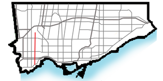
The Toronto waterway system comprises a series of natural and man-made watercourses in the Canadian city of Toronto. The city is dominated by a large river system spanning most of the city including the Don River, Etobicoke Creek, Highland Creek, Humber River, Mimico Creek and Rouge River.
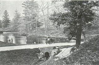
McCaul's Pond was located at the site of Hart House, on the University of Toronto campus. It was created by damming Taddle Creek in the early 1860s. Increased settlement and economic activity had already begun changing the creek from being the clear, free running watercourse that the early settlers had found. It had been so clean that it was a breeding ground for salmon, but over time had become a polluted watercourse. Damming the creek accelerated the dangers and the pond was drained prior to burying the University's portion of the creek in 1884.

Mud Creek is a mostly buried south-easterly tributary of the Don River in Toronto, Ontario, Canada. It has also been known at different times as Mount Pleasant Brook and Spring Valley Creek.
