Burke Brook

Last updated
Burke Brook
BureBrook.jpg
Toronto map.png
Red pog.svg
Location of the mouth of the creek in Toronto
Location
Country Canada
State Ontario
Region Greater Toronto Area
City Toronto
Physical characteristics
Source 
  location Glenview Senior Public School, Canada
  coordinates 43°43′14″N79°24′29″W / 43.720583°N 79.408013°W / 43.720583; -79.408013 Coordinates: 43°43′14″N79°24′29″W / 43.720583°N 79.408013°W / 43.720583; -79.408013
  elevation178 m (584 ft)
Mouth Don River
  location
Sunnybrook Park, Canada
  coordinates
43°43′14″N79°21′56″W / 43.720586°N 79.365653°W / 43.720586; -79.365653
  elevation
134 m (440 ft)
Length9 km (5.6 mi)
Basin features
River system Don River
Tributaries 
  leftNorth Toronto Storm Trunk Sewer

Burke Brook is a small stream in Toronto, Ontario. It is part of the Don River watershield, a major river that flows into Lake Ontario. The north end of the stream begins near Glenview Senior Public School. [1]

Contents

History

Burke Brooke used to start near Downsview Airport. The stream then went in a southeast direction to where it met the beginning of the stream today (just east of Glenview Senior Public School). After that the stream followed the current course to where it meets the West Don River. The total length of the stream was 9 kilometres (5.6 mi), with 6 kilometres (3.7 mi) being tributaries. [2]

Tributaries

Havergal Stream

Havergal Stream runs entirely through the property of Havergal College girls' school. The start of the stream is fed by local sewers and nearby springs. [3] The Havergal Stream then proceeds to meet the North Toronto Storm Trunk Sewer at the edge of the school property. The water of the stream flows into the North Toronto Storm Trunk Sewer, where the sewer meets the Burke Brook. [3]

Havergal Stream used to start under the intersection of Old Orchard Grove and Barse Street by the Baycrest Hospital. The length of the river was 1.5 kilometres (0.93 mi). The river left its source and proceeded in a south-south-east direction to the current grounds of Havergal College, where nowadays it pops ups from the ground. The stream then went to where the current North Toronto Storm Trunk Sewer is and then met the Burke Brook a little east of there. [3]

North Toronto Storm Trunk Sewer

The North Toronto Storm Trunk Sewer is a storm sewer location in North York, Toronto, Ontario. The sewer has two sections: one starts at Lawrence Avenue and follows the old Burke Brooke, and the other starts at Douglass Avenue and Bathurst Street. The North Toronto Storm Trunk Sewer was a Metropolitan Toronto project installed during the 1960s and 70s. Like other sewers build at that time, it was intended to help reduce sewage along the planned route for the Spadina Expressway. It was also intended to allow particle sewage separation in suburban boroughs served by smaller sewage plants and to open up more land for development. The sewer also links to the North York Storm Trunk Sewer by Douglass Avenue and Bathurst Street. The North Toronto Storm Trunk Sewer meets the Burke Brooke where it starts near Glenview Senior Public School [4]

Former tributaries

The Burke Brook use to have a total of 6 kilometres (3.7 mi) of tributary streams. [2]

Blythwood Stream

Blythwood Stream, which started by Glengowan Road and Strathgowan and also at Saint Leonards Avenue and Saint Ives Avenue. It is the closest tributary to the Don River. The two section merged at Strathgowan Road and Fidelia Avenue. The stream followed a course running just east of Blythdale Road almost parallel until it met Burke Brook. The length of the stream was around 1 kilometre (0.62 mi). [5]

Lawrence Park Stream

Lawrence Park Stream merged with the McDougall Stream by the Locke Library between Lawrence and Lympstone. The length of the Lawrence Park stream was 6 kilometres (3.7 mi) and the McDougall Stream was 1 kilometre (0.62 mi). The Lawrence Park Stream started by Wilson Avenue and Avenue Road, then headed to the point where it met the McDougall Stream, then it continued to the east side of Yonge Street to meet the Burke Brook near Yonge Street and Saint Edmunds Drive. The McDougall stream started just north of the Blythwood Stream and curved north and west to where it met the Lawrence Park Stream. [6]

Parks

Parks are in order from east to west.

Sunnybrook Park

Sunnybrook Park Sunnybrook park - summer (2).JPG
Sunnybrook Park

Sunnybrook Park is a major park in Toronto that connects to the Don Valley from the west. It is home to the Sunnybrook Stables, dog parks, and many sport fields. There are also many bike and walking paths, with a few car-accessible roads scattered throughout. The park is also known for its cricket. [7]

Burke Brook Ravine

The Burke Brook Ravine is a ravine that stretches from Sunnybrook Park to Bayview Avenue. The ravine has no official trail connection to Bayview Avenue but is accessible from Bayview Avenue by steeply sloping paths. [8]

Sunnydene Park

Sunnydene Park is a small park just to the east of Sherwood Park, to the west of Bayview Avenue. The park is near Sherwood Park and maps include it as part of Sherwood Park [1]

Sherwood Park

Sherwood Park is a park in Toronto. It contains a city maintenance building, a water park, a playground, and washrooms. It contains 2 paths to the left and right of the Burke Brook. It contains a dog-off-leash park to the south-east north of the Mount Hope Catholic Cemetery and west of Sunnydene Park. To the north of the park is Blythwood Road and the Blythwood Ravine. A road leads west out of the park to Sherwood Avenue. [9]

Blythwood Ravine Park

Blythwood Ravine Park is a ravine between Alexander Muir Memorial Gardens and Blythwood Road. It also has entrances and the end of Strathgowan Avenue and Glengowan Road. The park is quite skinny and acts as a connector park between Sherwood park and Alexander Muir Memorial Gardens/ Yonge Street. [1]

Alexander Muir Memorial Gardens

The wall with the song Maple Leaf Forever on it at Alexander Muir Memorial Gardens Alexander Muir Memorial Gardens Monument.jpg
The wall with the song Maple Leaf Forever on it at Alexander Muir Memorial Gardens

This park is between Blythwood Ravine Park and Yonge Street. It contains the tennis courts of the Lawrence Park Tennis Club and the fields of the Lawrence Park Lawn Bowling and Croquet Club. The main attraction of the park is the song The Maple Leaf Forever, a patriotic song about Canada, [10] by Alexander Muir, printed on a stone wall with stairs connected to the fields and gardens of the park. The park was originally located on the west side of Yonge Street across from the Mount Pleasant Cemetery to celebrate the Toronto centennial celebrations. To build the Yonge Subway the TTC paid over $100,000 to move the park, including the stone wall, to its current location in Lawrence Park. [11] [12] [13]

Duplex Parkette (and Glenview Parkette)

In Duplex Parkette, Burke Brook is underground in pipes. Glenview Parkette is two islands with pathways running through them. [1]

Chatsworth Ravine

Chatsworth is a ravine between Duplex Avenue and Glenview Senior Public School with a path running to Cheritan Avenue. It has a bridge in the middle moving the path from south of the river to north of the river. [1]

Street crossings

In order from east to west:

Related Research Articles

Don River (Ontario) River in Canada

The Don River is a watercourse in southern Ontario, that empties into Lake Ontario, at Toronto Harbour. Its mouth was just east of the street grid of the town of York, Upper Canada, the municipality that evolved into Toronto, Ontario. The Don is one of the major watercourses draining Toronto that have headwaters in the Oak Ridges Moraine.

North Toronto Place in Ontario, Canada

North Toronto is a former town and informal district located in the northern part of the Old Toronto district in Toronto, Ontario, Canada. Currently occupying a geographically central location within the city of Toronto, the Town of North Toronto was incorporated in 1890, when much of the area was still farmland, and annexed by the old city of Toronto in 1912. The name is still used to refer to the area in general, although Yonge–Eglinton and Midtown Toronto are officially used.

Lawrence Park, Toronto Neighbourhood in Toronto, Ontario, Canada

Lawrence Park is a neighbourhood in Toronto, Ontario, Canada. It is bordered by Yonge Street to the west and Bayview Avenue to the east, and from Blythwood Ravine on the south to Lawrence Avenue on the north. Lawrence Park was one of Toronto's first planned garden suburbs. Begun in the early part of the 20th century, it did not fully develop until after the Second World War. It was ranked the wealthiest neighbourhood in all of Canada in 2011.

Lawrence station (Toronto) Toronto subway station

Lawrence is a subway station on Line 1 Yonge–University in Toronto, Ontario, Canada. It is located under Yonge Street at Lawrence Avenue, in the Bedford Park, Lawrence Park and Lytton Park neighbourhoods.

Bayview Avenue Major north-south route in the Greater Toronto Area of Ontario

Bayview Avenue is a major north–south route in the Greater Toronto Area of Ontario. North of Toronto, in York Region, Bayview is designated as York Regional Road 34.

Toronto Belt Line Railway

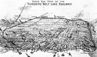
The Toronto Belt Line Railway was built during the 1890s in Toronto, Ontario, Canada. It consisted of two commuter railway lines to promote and service new suburban neighbourhoods outside of the then city limits. Both lines were laid as loops. The longer Don Loop ran north of the city limits, while the shorter Humber Loop ran west of the city limits. The railway was never profitable and it only ran for two years. Today, as part of a rails-to-trails project, the Beltline Trail lies on the right-of-way of the Don Loop.

Castle Frank Brook

Castle Frank Brook is a buried creek and south-west flowing tributary of the Don River in central and north-western Toronto, Ontario, originating near the intersection of Lawrence Avenue and Dufferin Street.

Lytton Park Neighbourhood in Toronto, Ontario, Canada

Lytton Park is a neighbourhood in Toronto, Ontario, Canada. It is located in the "North Toronto" municipality, within the former city of Toronto. The neighbourhood is centered on 'Lytton Park'. Its boundaries include: Mona Drive to the west, Yonge Street to the east, Lawrence Avenue West to the north and Briar Hill Avenue to the south.

Bridle Path–Sunnybrook–York Mills Neighbourhood in Toronto, Ontario, Canada

Bridle Path–Sunnybrook–York Mills is a municipal and census district in Toronto, Ontario, Canada, and it is the name officially designated by Toronto City Hall. Traditionally, Torontonians regard this area as five distinct neighbourhoods that were formerly in North York before it was amalgamated into Toronto in 1998. The area is part of the federal and provincial electoral district of Don Valley West, and Toronto electoral ward 25: Don Valley West (North).

Sunnybrook Park

Sunnybrook Park is a large public park in Toronto, Ontario, Canada. It is located north of Leaside and south of the Bridle Path areas of the city. The park is home to many bike trails, dog parks, and Sunnybrook Stables.

Mount Pleasant Road Arterial thoroughfare in Toronto, Canada

Mount Pleasant Road is a major arterial thoroughfare in Toronto, Ontario, Canada. The street extends from Jarvis Street south of Bloor Street north to Glen Echo Drive. The road is unique as one of the few arterial roads in Toronto to be created after the development of the suburbs which it passes through. These include the wealthy Rosedale, Moore Park and Lawrence Park neighbourhoods. The road also passes through the centre of Mount Pleasant Cemetery, after which it takes its name.

Beltline Trail Rail trail in Toronto, Ontario

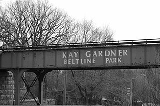
The Beltline Trail is a 9-kilometre (5.6 mi)-long cycling and walking rail trail in Toronto, Ontario, Canada. It consists of three sections, the York Beltline Trail west of Allen Road, the Kay Gardner Beltline Park from the Allen to Mount Pleasant Road, and the Ravine Beltline Trail south of Mount Pleasant Cemetery through the Moore Park Ravine. Built on the former right-of-way of the Toronto Belt Line Railway, the linear park passes through the neighbourhoods of Rosedale, Moore Park, Forest Hill, Chaplin Estates, and Fairbank.

Alexander Muir Memorial Gardens

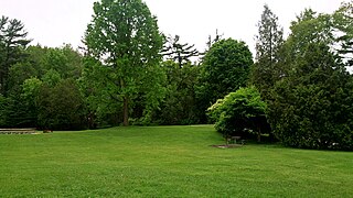
Alexander Muir Memorial Gardens is a municipal park in Toronto, Ontario, Canada. The park was created in 1933 by public subscription to honour Alexander Muir, who composed the song "The Maple Leaf Forever". The park was originally located opposite Mount Pleasant Cemetery on Yonge Street, but was moved to its present location in 1951 due to the construction of the Yonge subway. Today the park is in Toronto's Lawrence Park neighbourhood south of Lawrence Avenue with an entrance on the east side of Yonge Street.

Teddington Park is a neighbourhood in Toronto, Ontario, Canada. It is bordered by Yonge Street to the west and Bayview Avenue to the east, and from Snowden Road in the south to north of Glen Echo Road and Rosedale Golf Club. Development occurred in and around the 1930s, and was farmland before that time.

Yellow Creek (Toronto) Stream in Ontario, Canada

Yellow Creek, is a partially buried south-easterly tributary of the Don River in Toronto. It has also been known at different times as Silver Creek, Sylvan Creek, and also Rosedale Brook. The former source of Yellow Creek begins near Sheppard West station in the Downsview neighbourhood. Most of the creek and its sources are buried underground in storm sewers until they emerge into Avoca Ravine in the Deer Park neighbourhood and continues its way to the Don River.

Mud Creek (Toronto) Stream in Toronto, Canada

Mud Creek, is a mostly buried south-easterly tributary of the Don River in Toronto, Ontario, Canada. It has also been known at different times as Mount Pleasant Brook and Spring Valley Creek.

References

  1. 1 2 3 4 5 6 "Google Maps". Google Maps. Retrieved 2017-03-06.
  2. 1 2 "Burke Brook". www.lostrivers.ca. Retrieved 2017-12-05.
  3. 1 2 3 "Havergal Stream". www.lostrivers.ca. Retrieved 2017-12-06.
  4. "North Toronto Storm Trunk Sewer | Vanishing Point". www.vanishingpoint.ca. Retrieved 2017-12-06.
  5. "Blythwood Stream". www.lostrivers.ca. Retrieved 2017-12-06.
  6. "Lawrence Park Stream". www.lostrivers.ca. Retrieved 2017-12-06.
  7. Recreation, Toronto Parks, Forestry and. "Parks, Forestry and Recreation : Sunnybrook Park". www.toronto.ca. Retrieved 2017-12-06.
  8. "311 Knowledge Base". www.toronto.ca. Retrieved 2017-12-06.
  9. Recreation, Toronto Parks, Forestry and. "Sherwood Park". City of Toronto. Retrieved 2019-03-30.
  10. Cumming, Don. "mapleleafforever". www.chebucto.ns.ca. Retrieved 2017-12-06.
  11. "Alexander Muir Memorial Gardens". www.lostrivers.ca. Retrieved 2017-12-06.
  12. "Lawrence Park". Lawrence Park. Retrieved 2017-12-06.
  13. "Lawrence Park Tennis Club | Lawrence Park Tennis Club". lawrenceparktennisclub.ca. Retrieved 2017-12-06.