
Deer Park is a neighbourhood in Toronto, Ontario, Canada. It is centered on the intersection of Yonge Street and St. Clair Avenue and its boundaries are the Vale of Avoca section of Rosedale ravine in the east, Farnham Avenue and Jackes Avenue in the south, Avenue Road and Oriole Parkway in the west, the Beltline Trail in the north on the west side of Yonge Street, and Glen Elm Avenue in the north on the east side of Yonge Street. For the purposes of social policy analysis and research, the Toronto government’s Social Development & Administration division includes Deer Park within the City of Toronto's official "Rosedale-Moore Park" and "Yonge-St.Clair" neighbourhood profiles. The neighbourhood is in Ward 22, represented by Councillor Josh Matlow at Toronto City Council.

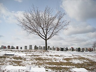
Moore Park is a neighbourhood in Toronto, Ontario, Canada. It is one of Toronto's most affluent neighbourhoods. Toronto Life ranked the Rosedale-Moore Park neighbourhood as the best neighbourhood to live in Toronto. It lies along both sides of St. Clair Avenue East between the Vale of Avoca ravine and Moore Park ravine. The northern boundary is Mount Pleasant Cemetery and the southern the Canadian Pacific Railway tracks.
Taddle Creek is a buried stream in Toronto, Ontario, Canada that flowed a southeasterly course about six kilometres long, from St. Clair Avenue west of Bathurst Street through the present site of Wychwood Park, through the University of Toronto, into the Toronto Harbour near the Distillery District. During the 19th century, it was buried and converted into an underground sewer, but traces of the creek can still be found today. The scenic footpath known as Philosopher's Walk follows the ravine created by the creek from the Royal Ontario Museum to Trinity College. Taddle Creek is also the name of a Toronto literary magazine and of a local Montessori school.

Garrison Creek was a short stream about 7.7 kilometres long that flowed southeast into the west side of Toronto Harbour in Ontario, Canada. It has been largely covered over and filled in, but geographical traces of the creek can still be found, including the natural amphitheatre known as Christie Pits and the off-leash dog "bowl" of Trinity Bellwoods Park. The name "Garrison Creek" was used because Fort York was built near the creek mouth. Volunteers lead popular tours of the course of the old watershed.

Trinity Bellwoods Park is a public park located in Toronto, Ontario, Canada, bordered by Queen Street West on the south and Dundas Street on the north. The western boundary of the park is Crawford Street, several hundred feet before Crawford intersects with Dundas St. West, the park juts toward Shaw Street, westside of the Crawford Street Bridge. Most of the park's area lies in the original Garrison Creek ravine and this creek, now a buried city storm sewer, still flows beneath the park from the northwest to the southeast corners.

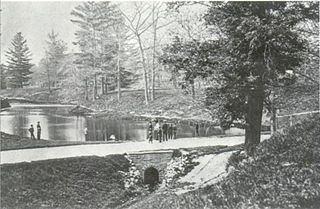
Vale of Avoca is a large viaduct that carries St. Clair Avenue East over a ravine of the same name, in Toronto, Canada. Located just east of Yonge Street, the current triple arch bridge, also known as the St. Clair Viaduct, was built to connect the well-established community of Deer Park with the developing community of Moore Park in the 1920s. The bridge replaced an older structure and straightened the alignment of St. Clair Avenue in the process.

Black Creek is a river in the Golden Horseshoe region of Ontario, Canada. It flows from the city of Vaughan in the Regional Municipality of York to the Humber River in Toronto. Black Creek is smaller than most of the waterways in the Greater Toronto Area.
Mount Hope Catholic Cemetery is a Catholic cemetery at 305 Erskine Avenue in Toronto, Ontario, Canada.

Cedarvale Park is a park located in Toronto, Ontario, Canada. It is bordered by very steep hills, and is located in the Cedarvale neighbourhood of Toronto. The Line 1 Yonge–University subway tunnels underneath it, between St. Clair West and Eglinton West stations; there are several TTC emergency exits in the park. The north end of the park contains the Phil White (Cedarvale) Arena and The Leo Baeck Day School, formerly Arlington Middle School. It is commonly used by dog walkers and students returning from the nearby school. The park contains a cricket pitch and soccer goals as permanent fixtures. In the winter, the larger hills within the park are used for tobogganing.

Dufferin Grove Park is a park in the Dufferin Grove neighbourhood of Toronto, Ontario, Canada. The park is located on the east side of Dufferin Street, south of Bloor Street West. It is located a block south of the Dufferin subway station and across the street from Dufferin Mall. The park extends two city blocks east and is primarily green-space with mixed open space and treed areas.

Castle Frank Brook is a buried creek and south-west flowing tributary of the Don River in central and north-western Toronto, Ontario, originating near the intersection of Lawrence Avenue and Dufferin Street.
The Toronto ravine system is a distinctive feature of the city's geography, consisting of a network of deep ravines, which forms a large urban forest that runs through most of Toronto. The ravine system is the largest in any city in the world, with the Ravine and Natural Feature Protection Bylaw protecting approximately 110 square kilometres (42 sq mi) of public and privately-owned land. The ravine system has been presented as a central characteristic of the city, with the size of the ravine system leading Toronto to be described as "a city within a park".

Mount Pleasant Road is a major arterial thoroughfare in Toronto, Ontario, Canada. The street extends from Jarvis Street south of Bloor Street north to Glen Echo Drive. The road is unique as one of the few arterial roads in Toronto to be created after the development of the suburbs which it passes through. These include the wealthy Rosedale, Moore Park and Lawrence Park neighbourhoods. The road also passes through the centre of Mount Pleasant Cemetery, after which it takes its name.
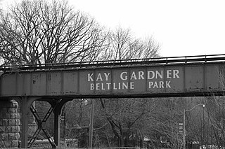
The Beltline Trail is a 9-kilometre (5.6 mi)-long cycling and walking rail trail in Toronto, Ontario, Canada. It consists of three sections, the York Beltline Trail west of Allen Road, the Kay Gardner Beltline Park from the Allen to Mount Pleasant Road, and the Ravine Beltline Trail south of Mount Pleasant Cemetery through the Moore Park Ravine. Built on the former right-of-way of the Toronto Belt Line Railway, the linear park passes through the neighbourhoods of Rosedale, Moore Park, Forest Hill, Chaplin Estates, and Fairbank.

Burke Brook is a small stream in Toronto, Ontario. It is part of the Don River watershield, a major river that flows into Lake Ontario. The north end of the stream begins near Glenview Senior Public School.

The Toronto waterway system comprises a series of natural and man-made watercourses in the Canadian city of Toronto. The city is dominated by a large river system spanning most of the city including the Don River, Etobicoke Creek, Highland Creek, Humber River, Mimico Creek and Rouge River.

David A. Balfour Park is an urban park in the Deer Park neighbourhood of Toronto near the intersection of Yonge Street and St. Clair Avenue. The park made up of 20.5 hectares of green space consisting of the greenery-covered Rosehill Reservoir and the entirety of the Vale of Avoca with its system of trails.

Mud Creek is a mostly buried south-easterly tributary of the Don River in Toronto, Ontario, Canada. It has also been known at different times as Mount Pleasant Brook and Spring Valley Creek.

