Davisville Yard

Last updated

Davisville Yard
Davisville TTC McBrien Building d83.JPG
North view from the Beltline Trail bridge
Overview
Locale Chaplin Estates, Toronto
Service
System Toronto subway
Operator(s) Toronto Transit Commission
History
Opened1954
Technical
Track gauge 4 ft 10+78 in (1,495 mm)
Electrification Third rail, 600 V DC
Route map

Contents

BSicon MFADEg.svg
BSicon uvSTR.svg
BSicon MFADEg.svg
BSicon RP2.svg
BSicon SUBWAY.svg TTC - Line 1 - Yonge-University-Spadina line.svg to Finch
BSicon hRP2aq.svg
BSicon MSTRq.svg
BSicon hRP2q.svg
BSicon uvSTRfg.svg
BSicon hRP2eq.svg
BSicon RP2xRP2.svg
Lola Road
BSicon uvENDEa-.svg
BSicon uvUSTr.svg
BSicon RP2e.svg
BSicon RP2wRP2.svg
BSicon uvSHI4+l-.svg
BSicon uvSTR-.svg
BSicon uvSTRfg.svg
BSicon uvSHI4r-.svg
BSicon RP2.svg
BSicon hRP2aq.svg
BSicon MSTRq.svg
BSicon hRP2q.svg
BSicon uvSTR-.svg
BSicon MSTRq.svg
BSicon hRP2q.svg
BSicon uvSTRfg.svg
BSicon hRP2eq.svg
BSicon RP2xRP2.svg
Imperial Street
BSicon uSTRc2.svg
BSicon uvABZg3-.svg
BSicon uvSTRfg.svg
BSicon RP2.svg
BSicon uSTRc2.svg
BSicon uSTR3+1.svg
BSicon uv-STR+1.svg
BSicon uSTRc4.svg
BSicon uvSTR-.svg
BSicon uvSTRfg.svg
BSicon RP2.svg
BSicon uSTRc2.svg
BSicon uv-STR+1.svg
BSicon uSTR3+1.svg
BSicon uvSTR+1-.svg
BSicon uSTRc4.svg
BSicon uv-STR.svg
BSicon uvSTR-.svg
BSicon uvSTRfg.svg
BSicon RP2.svg
BSicon uv-STR+1.svg
BSicon uSTRc4.svg
BSicon uvSTR.svg
BSicon uv-SHI2gr.svg
BSicon uvSTR-.svg
BSicon uvSTRfg.svg
BSicon RP2.svg
BSicon lhvSTR(l).svg
BSicon lhvSTR(l)q.svg
BSicon utvSTR.svg
BSicon lhvSTR(l).svg
BSicon lhvSTR(l)q.svg
BSicon utvSTR.svg
BSicon udSTR.svg
BSicon BSl.svg
BSicon uvSTR-.svg
BSicon uvSTRfg.svg
BSicon BSr.svg
BSicon RP2.svg
BSicon MSTRq.svg
BSicon hRP2aq.svg
BSicon lhvSTR(l).svg
BSicon MSTRq.svg
BSicon hRP2q.svg
BSicon utvSTR.svg
BSicon lhvSTR(l).svg
BSicon MSTRq.svg
BSicon hRP2q.svg
BSicon utvSTR.svg
BSicon MSTRq.svg
BSicon hRP2q.svg
BSicon udSTR.svg
BSicon BSl.svg
BSicon MSTRq.svg
BSicon hRP2q.svg
BSicon uvSTR-.svg
BSicon MSTRq.svg
BSicon hRP2q.svg
BSicon uvSTR.svg
BSicon MSTRq.svg
BSicon hRP2eq.svg
BSicon BSr.svg
BSicon RP2xRP2.svg
Davisville Avenue
BSicon lhvSTR(l).svg
BSicon utvSTR.svg
BSicon lhvSTR(l).svg
BSicon utvSTR.svg
BSicon udSTR.svg
BSicon BSl.svg
BSicon uvSTR-.svg
BSicon uvSTRfg.svg
BSicon BUILDING.svg
BSicon BSr.svg
BSicon RP2.svg
Davisville station
BSicon lhvSTR(r).svg
BSicon lhvSTR(l)q.svg
BSicon lvENDE@F.svg
BSicon lhvSTR(l)q.svg
BSicon lvENDE@F.svg
BSicon utvSTR.svg
BSicon lhvSTR(r)q.svg
BSicon lhvSTR(l).svg
BSicon utvSTR.svg
BSicon udSTR.svg
BSicon BSl.svg
BSicon uvSTR-.svg
BSicon uvSTRfg.svg
BSicon BSr.svg
BSicon RP2.svg
William McBrien Building
 
BSicon lhvSTR(r)q.svg
BSicon lhvSTR(r).svg
BSicon utvSTR.svg
BSicon lhvSTR(r)q.svg
BSicon utvSTR.svg
BSicon lhvSTR(r)q.svg
BSicon lhvSTR(l).svg
BSicon utvSTR.svg
BSicon udABZg+l.svg
BSicon uv-SHI2+l.svg
BSicon uvSHI2r-.svg
BSicon uv-SHI2gr.svg
BSicon uvSHI2r-.svg
BSicon uvSTR-.svg
BSicon uvSTRfg.svg
BSicon RP2.svg
BSicon uv-STR.svg
BSicon uvENDEa-.svg
BSicon uvSTR.svg
BSicon uvSTR.svg
BSicon uv-SHI2+l.svg
BSicon uvSHI2g+l-.svg
BSicon uvSHI2r-.svg
BSicon uv-SHI2gr.svg
BSicon uvSTR-.svg
BSicon uvSTRfg.svg
BSicon RP2.svg
BSicon lENDE@Gq.svg
BSicon uSTR2+r.svg
BSicon uSTRc3.svg
BSicon uv-SHI2g+r.svg
BSicon uvSTR.svg
BSicon uvSTR.svg
BSicon uvSTR-.svg
BSicon uvSHI2+l.svg
BSicon uv-SHI2gr.svg
BSicon uvSHI2r-.svg
BSicon uv-STR2.svg
BSicon uSTRc3.svg
BSicon uvSHI4l-.svg
BSicon uvSHI4+r-.svg
BSicon uvSTR.svg
BSicon RP2.svg
BSicon uSTRc1.svg
BSicon uSTR2+4.svg
BSicon uv-STR2.svg
BSicon uSTRc3.svg
BSicon uvSTR.svg
BSicon uvSTR.svg
BSicon uvSTR.svg
BSicon uSTRc1.svg
BSicon uvSTR.svg
BSicon uSPL+4.svg
BSicon uvSTR.svg
BSicon RP2.svg
BSicon fCONTgq.svg
BSicon uSTRc1.svg
BSicon lhSTRaq.svg
BSicon uSTR2+4.svg
BSicon lhMSTRq.svg
BSicon fSTRq.svg
BSicon uSPLg+2.svg
BSicon fSTRq.svg
BSicon uSTRc3.svg
BSicon uvKRZh.svg
BSicon fSTRq.svg
BSicon uvKRZh.svg
BSicon fSTRq.svg
BSicon uvKRZh.svg
BSicon fSTRq.svg
BSicon uvKRZh.svg
BSicon fSTRq.svg
BSicon uvKRZh.svg
BSicon fSTRq.svg
BSicon lhSTRq.svg
BSicon fSTRq.svg
BSicon hSKRZ-G2eq.svg
Beltline Trail
BSicon uSTRc1.svg
BSicon uSTR2+4.svg
BSicon uSPLg+2.svg
BSicon uSTRc3.svg
BSicon uvSTR.svg
BSicon uvSTR.svg
BSicon uvSTR.svg
BSicon uvUSTl.svg
BSicon RP2.svg
BSicon uSTRc1.svg
BSicon uSTR2+4.svg
BSicon uSPLg+2.svg
BSicon uSTRc3.svg
BSicon uvSTR.svg
BSicon uvSTR.svg
BSicon uvSTRfg.svg
BSicon RP2.svg
BSicon uSTRc1.svg
BSicon uSTR2+4.svg
BSicon uSPLg+2.svg
BSicon uSTRc3.svg
BSicon uvSTR.svg
BSicon uvSTRfg.svg
BSicon RP2.svg
BSicon uSTRc1.svg
BSicon uv-STR+4.svg
BSicon uvSHI2l-.svg
BSicon uv-STR.svg
BSicon uvSTRfg.svg
BSicon RP2.svg
BSicon uv-STR.svg
BSicon uvSTRfg.svg
BSicon RP2.svg
BSicon uv-ENDEe.svg
BSicon uvSTRfg.svg
BSicon RP2.svg
BSicon PORTALg.svg
BSicon MFADEf.svg
BSicon utvSTR.svg
BSicon MFADEf.svg
BSicon RP2.svg
BSicon SUBWAY.svg TTC - Line 1 - Yonge-University-Spadina line.svg to Union

The Davisville Subway Yard is a rail yard on the Toronto Transit Commission's Yonge subway line. The train maintenance and storage building is referred to as the Davisville Carhouse. [1]

Location

The yard is located adjoining the Davisville station, between Eglinton and St. Clair stations. The yard is next to the TTC headquarters in the William McBrien Building at 1900 Yonge Street.

History

Davisville Yard under construction, c. 1953 Davisville Yard 1953.jpg
Davisville Yard under construction, c. 1953

Davisville Yard acted as the main maintenance and storage yard for Toronto's Yonge subway, which opened between Union Station and Eglinton Avenue in 1954. [2] The first two subway cars (5000 and 5001) were delivered to the TTC's Hillcrest Complex, but subsequent subway cars were delivered to Davisville yard via the Toronto Belt Line Railway. Before the opening of the subway, there was a temporary interchange track between the Yonge streetcar line and the Davisville Yard on the north side of the Belt Line bridge for the interchange of rail equipment with the streetcar system. [3] In 1953, subway cars 5000 and 5001, after being displayed at the Canadian National Exhibition, were mounted on shop bogies and towed at night over streetcar tracks by a Peter Witt motor to the Davisville Yard via the temporary interchange. (The two subway cars had arrived at the CNE from Hillcrest via the Bathurst streetcar line. At the CNE, the two cars were displayed on their own bogies.) [4]

The Davisville Carhouse could not handle heavy repair work for subway bogies. Thus, until the shops at Greenwood Yard were opened in 1965, bogies needed to be shipped by truck to the Hillcrest Complex on a specially built trailer. According to rail historians John F. Bromley and Jack May, this was the reason that the subway was built to the streetcar gauge of 1495mm, which is the gauge used for shop tracks at Hillcrest. [5]

There used to be an upper yard having 2 parallel stub tracks plus a shorter stub siding all running parallel to the former Belt Line Railway line (today the Kay Gardner Beltline Park). Another track, located on an incline, connected the upper and lower yards; today, a short stub siding on the west side of the yard is all that is left of that connecting track. Various pieces of work equipment were stored in the upper yard. [6]

Davisville was Toronto's sole subway yard until 1966, when Greenwood Yard opened. Subway car deliveries were also shifted to Greenwood at this time. While usage of it began to wane, it remained active even as the larger Wilson Yard opened in 1978. [7] The yard became deactivated after 1993, when repairs were required to a retaining wall to the south of the yard. Even after this work was completed, the yard remained inactive as the TTC had become quite satisfied with the temporary storage and maintenance arrangement during the closure. The yard was temporarily reactivated during the 1995 Russell Hill subway accident, and also during the retirement of older rolling stock (H-1/H-2, M-1). The subway yard was formally reactivated in June 2002, a few months prior to the opening of Line 4 Sheppard. [7]

In November 2018, the TTC completed the extension the carhouse over tracks 3 and 4 on the east side of the building. Track 3 is the wash track and track 4 is utilized for interior cleaning and floor washing of the vehicles. Before the extension, tracks 3 and 4 were long enough for only four-car trains within the carhouse building, and the overhead doors on the north and south end had to remain open to service six-car TR trains. The open doors also exposed equipment to freezing in winter. With the extension, the TTC can use tracks 3 and 4 for the overnight storage of six-car TR trains. [1] [8]

Current operations

A G-series train at Davisville, c. 1969 The Red Rocket.jpg
A G-series train at Davisville, c. 1969
Trains at Davisville yard, seen from Davisville station c. 2009 Davisville subway trains.jpg
Trains at Davisville yard, seen from Davisville station c. 2009

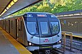
Davisville Yard is home to a small portion of the TTC's revenue rolling stock of Toronto Rocket subway trains which operate on Line 1 Yonge-University and Line 4 Sheppard and some of the Commission's work cars. The facility is used to store, service and maintain subway cars. The yard can dispatch 12 trains onto Line 1, and this minimizes the need to deadhead trains from the Wilson Yard. In addition to exterior storage tracks, the yard's carhouse has 8 tracks to perform safety inspections, unscheduled repairs, floor washing and exterior washing. Many Subway Infrastructure sections including Track, Structures, and Signals are also based at the Davisville Yard. [1]

Future

In 2022, the city of Toronto was studying a proposal to deck over the Davisville Yard in order to build a 1-hectare (2.5-acre) park over the yard. The yard, the adjacent subway station, a substation and signal facility would remain in operation during construction. The city owns the Davisville Yard. [9]

Related Research Articles

<span class="mw-page-title-main">Toronto subway</span> Rapid transit system in Ontario, Canada

The Toronto subway is a rapid transit system serving Toronto and the neighbouring city of Vaughan in Ontario, Canada, operated by the Toronto Transit Commission (TTC). It is a multimodal rail network consisting of three heavy-capacity rail lines operating predominantly underground, and one elevated medium-capacity rail line. Two light rail lines, which will operate both at-grade and underground, are under construction.

<span class="mw-page-title-main">Toronto Railway Company</span> Streetcar operator in Toronto, Canada, between 1891 and 1921

The Toronto Railway Company (TRC) was the operator of the streetcar system in Toronto between 1891 and 1921. It electrified the horsecar system it inherited from the Toronto Street Railway, the previous operator of streetcar service in Toronto. The TRC was also a manufacturer of streetcars and rail work vehicles, a few of which were built for other streetcar and radial operators.

<span class="mw-page-title-main">Toronto Civic Railways</span> Streetcar operator in Toronto, Canada, from 1912 to 1921

Toronto Civic Railways (TCR) was a streetcar operator created and owned by the City of Toronto, Ontario, Canada, to serve newly annexed areas of the city that the private operator Toronto Railway Company refused to serve. When the Toronto Railway Company's franchise expired in 1921, its services were combined with those of the Toronto Civic Railways, and are now assumed by the new Toronto Transportation Commission (TTC). The first route of the TCR started operation on December 18, 1912.

<span class="mw-page-title-main">Metropolitan Street Railway (Toronto)</span> Toronto railway electric radial line

The Metropolitan Street Railway was the operator of the Metropolitan line in the Toronto area that started out as a local horsecar line and transformed itself into an electric radial line extending to Lake Simcoe, following an old stage coach route. In 1904, the railway was acquired by the Toronto and York Radial Railway (T&YRR) and became the T&YRR Metropolitan Division. In 1922, the City of Toronto acquired the T&YRR and contracted Ontario Hydro to manage the four T&YRR lines including the Metropolitan. In 1927, the TTC took over the operation of the Metropolitan Line to Sutton, and renamed it the Lake Simcoe line. In 1930, the TTC closed the Metropolitan Line but shortly reopened the portion between Glen Echo and Richmond Hill operating it as the North Yonge Railways until 1948.

<span class="mw-page-title-main">North Yonge Railways</span>

The North Yonge Railways was a radial railway line operated by the Toronto Transportation Commission from 1930 to 1948 between Glen Echo (Toronto) and Richmond Hill. The line was created by reopening the southern portion of the TTC's Lake Simcoe radial line that had closed in 1930.

<span class="mw-page-title-main">Toronto streetcar system</span> Streetcar network in Ontario, Canada

The Toronto streetcar system is a network of nine streetcar routes in Toronto, Ontario, Canada, operated by the Toronto Transit Commission (TTC). It is the busiest light-rail system in North America. The network is concentrated primarily in Downtown Toronto and in proximity to the city's waterfront. Much of the streetcar route network dates from the 19th century. Most of Toronto's streetcar routes operate on street trackage shared with vehicular traffic, and streetcars stop on demand at frequent stops like buses.

<span class="mw-page-title-main">Greenwood Yard</span>

The Greenwood Yard is a rail yard with support buildings that service subway vehicles on Line 2 Bloor–Danforth of the Toronto subway.

<span class="mw-page-title-main">Wilson Yard</span>

Wilson Yard is the largest of the Toronto Transit Commission's subway yards and bus garages. The subway yard services subway trains on Line 1 Yonge–University. The facility is located on Transit Road north of Wilson Avenue, in the former city of North York, between Wilson and Sheppard West stations.

<span class="mw-page-title-main">Presidents' Conference Committee (Toronto streetcar)</span>

The Presidents' Conference Committee Car was a streetcar used by the Toronto Transportation Commission and the Toronto Transit Commission. The PCC streetcar was designed by the Presidents' Conference Committee, a group of transit operators in the United States and Canada.

<span class="mw-page-title-main">Toronto subway rolling stock</span> Listing of Toronto subway systems rolling stock

The Toronto subway system's rolling stock consists of 880 subway cars for Line 1 Yonge–University, Line 2 Bloor–Danforth, and Line 4 Sheppard and 28 intermediate-capacity rapid transit cars for Line 3 Scarborough. The rolling stock is owned and maintained by the Toronto Transit Commission (TTC).

<span class="mw-page-title-main">Roncesvalles Carhouse</span> Storage and maintenance facility for streetcars in Toronto, Canada

The Roncesvalles Carhouse is a storage and maintenance facility for the streetcar network of the Toronto Transit Commission. Located at the northwest corner of The Queensway and Roncesvalles Avenue in Toronto, Ontario, west of its downtown core, it is the oldest of the TTC's three active carhouses. The carhouse serves vehicles on routes 501 Queen, 504 King, 505 Dundas, 506 Carlton, 511 Bathurst, and 512 St. Clair.

<span class="mw-page-title-main">Russell Carhouse</span> Rail yard of the Toronto Transit Commission

The Russell Carhouse, located at Queen Street East and Connaught Avenue just east of Greenwood Avenue in Toronto, is the Toronto Transit Commission's second oldest carhouse.

<span class="mw-page-title-main">Toronto streetcar system rolling stock</span> History of the Canadian citys streetcar system rolling stock

In 1921, the Toronto Transportation Commission (TTC) was created to integrate and operate the Toronto streetcar system. It inherited the infrastructure of two separate streetcar operators: the Toronto Railway Company (TRC) and Toronto Civic Railways (TCR). The TTC immediately embarked on a program to connect the TRC and TCR lines into one network. The TTC had to rebuild most of the track to provide a wider devilstrip so that the wider Peter Witt streetcars it was ordering could pass without sideswiping. Between 1938 and 1945, it placed five orders for air-electric PCC streetcars to replace the old, wooden streetcars of the TRC, and to address rising ridership. Between 1947 and 1951, the TTC placed three orders for all-electric PCC cars, with one order equipped with couplers for multiple-unit operation. Between 1950 and 1957, the TTC purchased PCCs from four American cities. By 1957, the TTC had more PCCs than any other city in North America. After the opening of the Bloor–Danforth subway in 1966, the TTC considered terminating all streetcar service in Toronto. However, in 1972, a citizens group led by Jane Jacobs and Steve Munro called "Streetcars for Toronto" persuaded the City to retain streetcar operation. This led to the development of the Canadian Light Rail Vehicle (CLRV) and its longer, articulated cousin, the Articulated Light Rail Vehicle (ALRV), to replace the aging PCC fleet. The Accessibility for Ontarians with Disabilities Act, 2005 (AODA) mandated that the next generation of streetcars be wheelchair-accessible. Thus, to replace the CLRVs and ALRVs, Bombardier adapted its low-floor Flexity Outlook model for the TTC to navigate the Toronto streetcar system's tight curves and single-point switches, characteristics set in the 1920s to accommodate Peter Witt streetcars.

<span class="mw-page-title-main">Leslie Barns</span> Streetcar maintenance and storage facility in Toronto

Leslie Barns is a streetcar maintenance and storage facility at the southeast corner of Leslie Street and Lake Shore Boulevard in Toronto, Ontario, Canada. It has been built to house and service the majority of Toronto Transit Commission's fleet of Flexity Outlook light rail vehicles.

<span class="mw-page-title-main">Yonge streetcar line</span>

Beginning operation in 1861, the Yonge streetcar line was the first streetcar line in Toronto and the first in Canada. It started off as a horsecar line and closed in 1954 operating two-unit trains of Peter Witt motors pulling a trailer. Under the Toronto Transportation Commission, the Yonge line was the busiest and most congested streetcar line in the city leading to its replacement in 1954 by the Yonge Subway line, also Toronto's first and the first in Canada.

The Toronto Transit Commission (TTC) maintains four rapid transit lines and 75 stations on 76.9 km (47.8 mi) of route.

<span class="mw-page-title-main">Hillcrest Complex</span> Maintenance facility of the Toronto Transit Commission

Hillcrest Complex is the Toronto Transit Commission's largest facility and is responsible for most of the maintenance work on the system's surface vehicles, including heavy overhauls, repairs and repainting. It is located adjacent to the intersection of Bathurst Street and Davenport Road. The site is also home to the TTC's Transit Control Centre, but the operational headquarters of the organization remain at the McBrien Building at 1900 Yonge Street.

<span class="mw-page-title-main">Keele Yard</span>

Keele Yard is a rail yard on the Toronto Transit Commission's (TTC's) Line 2 Bloor–Danforth of the Toronto subway system. Keele Yard is located between Dundas West and Keele stations.

<span class="mw-page-title-main">Toronto-gauge railways</span> Railway track gauge (1495 mm)

Toronto-gauge railways are tram and rapid transit lines built to Toronto gauge, a broad gauge of 4 ft 10+78 in. This is 2+38 in (60 mm) wider than standard gauge of 4 ft 8+12 in which is by far the most common track gauge in Canada. The gauge is unique to the Greater Toronto Area and is currently used on the Toronto streetcar system and the Toronto subway, both operated by the Toronto Transit Commission. As well, the Halton County Radial Railway, a transport museum, uses the Toronto gauge so its rail line can accommodate its collection of Toronto streetcars and subway trains. Several now-defunct interurban rail systems also once used this gauge.

<span class="mw-page-title-main">St. Clair Carhouse</span> Streetcar depot facility in Toronto, Ontario

The St. Clair Carhouse was a streetcar facility in Toronto, Ontario, Canada. It was located south of St. Clair Avenue on a parcel of land bounded by Wychwood Avenue on the east, Benson Avenue on its north side and Christie Street on the west side. It was opened by the Toronto Civic Railways in 1913, taken over by the Toronto Transportation Commission in 1921 and closed by its successor, the Toronto Transit Commission, in 1998. The carhouse was subsequently transformed into a community centre called the Wychwood Barns.

References

  1. 1 2 3 "Davisville Carhouse – Carhouse Expansion" (PDF). Toronto Transit Commission. November 30, 2016. Retrieved December 7, 2016.
  2. "A Cavalcade of Progress, 1921-1954". Toronto Transit Commission. Retrieved November 20, 2016.
  3. Baldwin Collection (1953). "Yonge St. looking n. from G.T.R. Belt Line bridge s. of Merton St". Toronto Public Library . Retrieved September 21, 2016.
  4. John F. Bromley and Jack May (1973). 50 Years of Progressive Transit. Electric Railroaders' Association. pp.  83. ISBN   9781550024487 . Retrieved August 31, 2016. Chapter 8 - Postwar Change
  5. John F. Bromley and Jack May (1973). 50 Years of Progressive Transit. Electric Railroaders' Association. pp.  85, 107. ISBN   9781550024487 . Retrieved August 31, 2016. Chapter 9 - Subway City; Chapter 11 - The Crosstown Subway
  6. Harvey Naylor (July 8, 1961). "The Davisville Subway Yards". Transit Toronto. Retrieved December 8, 2016. Here, we see an aerial view of the west side of Davisville Yards, looking north, with a number of work cars in view, including a tunnel gauge car and RT-4, the ex-Peter Witt garbage train. Photo by Harvey Naylor, courtesy the John Knight collection.
  7. 1 2 Bow, James; Lubinski, Robert (December 19, 2015). "The Davisville Subway Yards" . Retrieved November 20, 2016.
  8. "Financial Update for the Year Ended December 31, 2018 and Major Projects Update" (PDF). Toronto Transit Commission. April 11, 2019. Retrieved April 17, 2019.
  9. Spurr, Ben (May 27, 2022). "Rail Deck Park has stalled, but a similar plan is now being proposed for TTC's Davisville yard". Toronto Star .

Coordinates: 43°41′50″N79°23′51″W / 43.69729°N 79.39753°W / 43.69729; -79.39753