502 Downtowner

Last updated
502 Downtowner
CLRV 4064 on 502 Downtowner.jpg
502 Downtowner car on Kingston Road,
travelling westbound at Main Street
Overview
StatusDiscontinued [1]
Locale Toronto, Ontario
Termini
Stations
Service
Type Streetcar route
Route number502
Operator(s) Toronto Transit Commission
Depot(s)Birchmount [2] [3]
Rolling stock Temporary replacement bus service
Technical
Line length9.38 km (5.83 mi) [3]
Track gauge 4 ft 10+78 in (1,495 mm)
Electrification 600 V DC overhead
Route map

Contents

BSicon uWSL+l.svg
BSicon uSTRc2.svg
BSicon uCONTg.svg
BSicon uSTR3.svg
BSicon uABZg+1.svg
BSicon ul-HST.svg
BSicon uSTRc4.svg
Queen Street West / McCaul Street ↑
BSicon CLRV.svg   501  
BSicon uHST.svg
St. Patrick Street
BSicon uINT.svg
University Avenue (Osgoode station)
BSicon BUS1.svg  142  TTC - Line 1 - Yonge-University-Spadina line.svg
BSicon uHST.svg
York Street
BSicon uINT.svg
Bay Street
BSicon BUS1.svg  6  6A 
BSicon uINT.svg
Yonge Street (Queen station)
BSicon BUS1.svg  97B  TTC - Line 1 - Yonge-University-Spadina line.svg
BSicon uHST.svg
Victoria Street (Saint Michael's Hospital)
BSicon uHST.svg
Church Street
BSicon uHST.svg
Jarvis Street
BSicon uHST.svg
Sherbourne Street
BSicon BUS1.svg  75 
BSicon uHST.svg
Ontario Street
BSicon uHST.svg
Parliament Street
BSicon BUS1.svg  65 
BSicon uHST.svg
Sackville Street
BSicon uHST.svg
Sumach Street
BSicon uCONTg.svg
BSicon uHST.svg
River Street
BSicon uKRWl.svg
BSicon uKRWg+r.svg
King Street East
503 & 504 to downtown
BSicon CONTgq.svg
BSicon umhKRZa.svg
BSicon CONTfq.svg
Metrolinx Bala Subdivision
BSicon dWASSERq.svg
BSicon uhKRZW.svg
BSicon dWASSERq.svg
BSicon dRP4q.svg
BSicon uhSKRZ-G4e.svg
BSicon dRP4q.svg
Don Valley Parkway
BSicon uHST.svg
Carroll Street
BSicon CLRV.svg   503    504  
BSicon lINT.svg
BSicon uABZgl.svg
BSicon uCONTfq.svg
Broadview Avenue
BSicon CLRV.svg   504  
BSicon uHST.svg
↓ Saulter Street / Boulton Avenue ↑
BSicon CONTgq.svg
BSicon umKRZu.svg
BSicon CONTfq.svg
Metrolinx Kingston Subdivision
BSicon uHST.svg
Empire Avenue
BSicon uHST.svg
Logan Avenue
BSicon uINT.svg
Carlaw Avenue
BSicon BUS1.svg  72 
BSicon uHST.svg
Pape Avenue
BSicon BUS1.svg  72A 
BSicon uHST.svg
↓ Caroline Avenue / Brooklyn Avenue ↑
BSicon uHST.svg
Jones Avenue
BSicon BUS1.svg  83 
BSicon uHST.svg
Leslie Street
BSicon uHST.svg
↓ Laing Street / Alton Avenue ↑
BSicon uHST.svg
Greenwood Avenue
BSicon BUS1.svg  31 
BSicon uv-SHI2gr.svg
BSicon uvDST-STR.svg
Russell Carhouse
BSicon uv-SHI2g+r.svg
BSicon uHST.svg
Woodfield Road
BSicon uINT.svg
Coxwell Avenue
BSicon BUS1.svg  22 
BSicon uINT.svg
↓ Kingston Road / Queen Street East↑
BSicon BUS1.svg  22B  BSicon CLRV.svg   501  
BSicon uWSLgl.svg
BSicon uKRWl.svg
BSicon uKRW+r.svg
Woodbine Loop
BSicon uCONTf.svg
BSicon uSTR.svg
BSicon uHST.svg
↓ Dixon Avenue / Dundas Street East
BSicon uHST(L).svg
Columbine Avenue
BSicon uHST(R).svg
Rainsford Road
BSicon uINT.svg
Woodbine Avenue
BSicon BUS1.svg  92 
BSicon uHST.svg
Elmer Avenue
BSicon uHST.svg
↓ Waverly Road / Brookside Drive ↑
BSicon uHST.svg
Lee Avenue
BSicon uINT.svg
Main Street (Southwood Drive)
BSicon BUS1.svg  64 
BSicon uHST.svg
Glen Manor Drive
BSicon uHST.svg
Beech Avenue
BSicon uHST.svg
Scarborough Road
BSicon uHST(L).svg
Bingham Avenue
BSicon uHST(R).svg
Victoria Park Avenue
BSicon uKINTe.svg
Bingham Loop
BSicon BUS1.svg  12  22A  BSicon CLRV.svg   503  

BSicon uINT.svg
Transfer stop
BSicon uHST.svg
intermediate stop
BSicon udDST.svg
Carhouse
Route:
Connection  00  Terminus  00 

The 502 Downtowner was a streetcar route operated by the Toronto Transit Commission in Toronto, Ontario, Canada. It ran from the Bingham Loop at Victoria Park Avenue and Kingston Road in the Beaches neighbourhood to McCaul Loop in downtown Toronto. Starting in September 2019, all streetcar services along Kingston Road were consolidated into the 503 Kingston Rd route. [4] [5] [1]

Route

502 Downtowner runs southwest on Kingston Road then turns west along Queen Street. It goes west along Queen to McCaul Street where there is a turning loop just north of Queen Street West. The route is grouped together with the 503 Kingston Rd for accounting purposes, as they share a large amount of the same track. [6]

The 502 Downtowner runs during the day from Monday to Friday only, overlapping rush-hour service provided by 503 Kingston Rd streetcars, both covering much of the same route. [7] Evening, weekend and holiday service is provided by the 22A Coxwell bus route replacing streetcar service along Kingston Road. [8] The section to the west of Queen and Coxwell is served by the 501 Queen and 504 King streetcars. Both of these routes have all day services. [9] [10]

History

A streetcar route along Kingston Road and Queen Street between Victoria Park Avenue and McCaul Street has existed under various route names and with some variations in routing since about 1930, according to TTC system maps and ride guides. [11]

By 1930, the Queen streetcar route (not the same as today's 501 Queen) ran from the Birchmount Loop to the McCaul Loop. A 1930 system map indicates that some streetcars turned back at the Bingham Loop, while an extra fare was required to go beyond Victoria Park Avenue to the Birchmount Loop. [12]

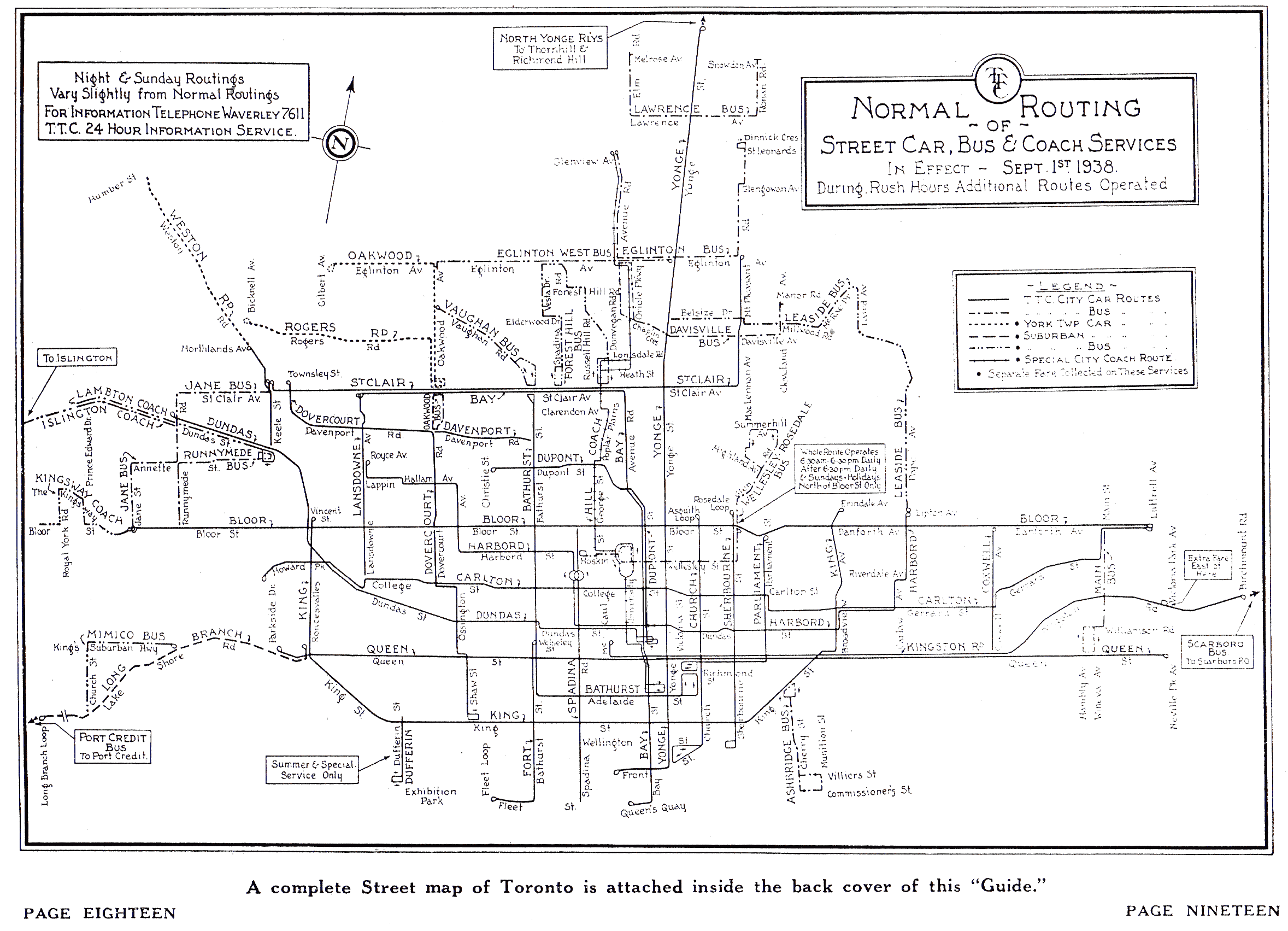
By September 1938, the route from the Birchmount Loop to the McCaul Loop had by then been renamed from "Queen" to "Kingston Rd" (not the same as today's 503 Kingston Rd). Despite the name change, there was no change in routing. [13]

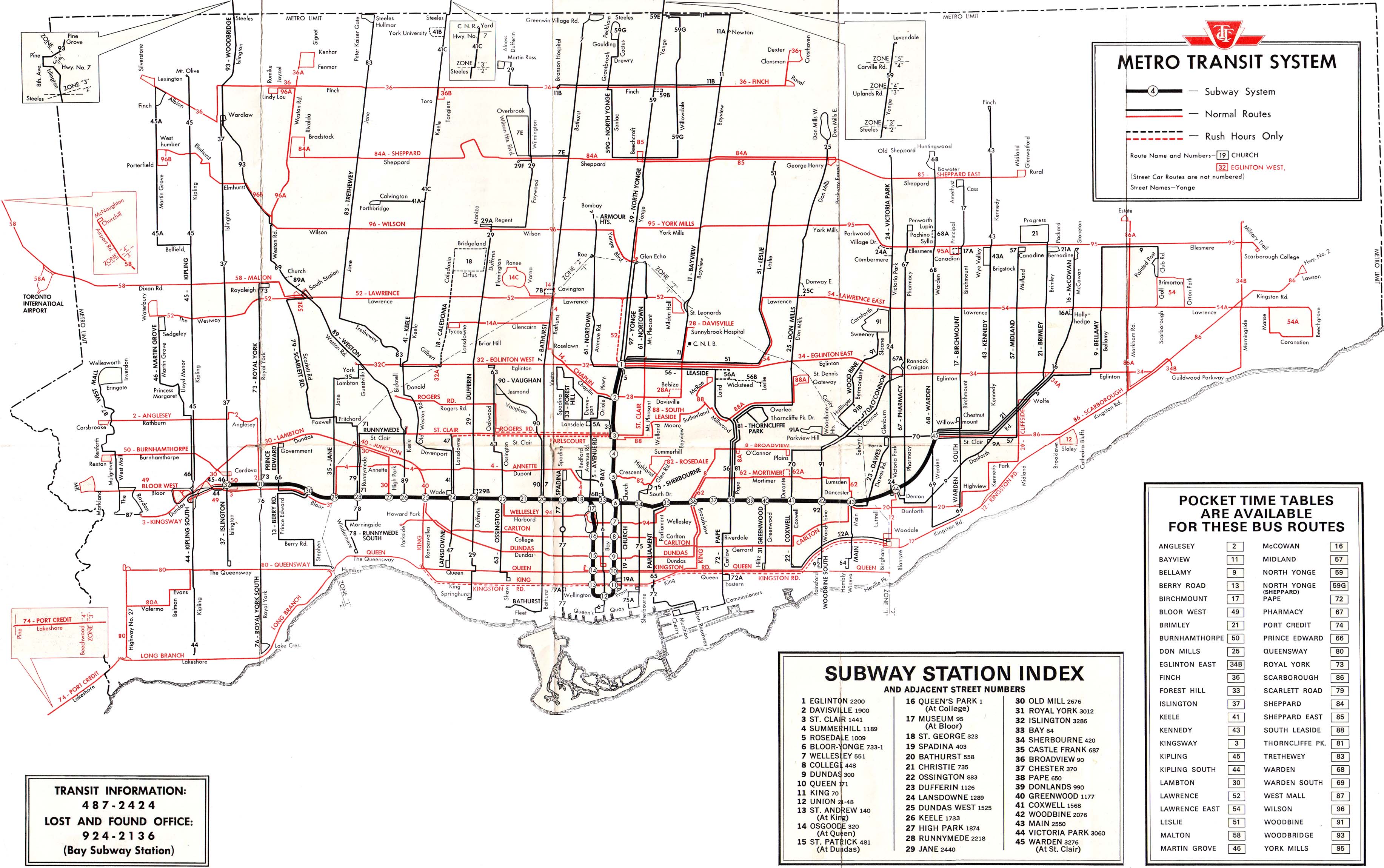
On July 1, 1954, the Birchmount Loop was abandoned and the Bingham Loop became the eastern terminal of the Kingston Rd route. Thus, in 1954, the Kingston Rd route became identical to the present-day 502 Downtowner route. [14]

Prior to 1966, the Coxwell streetcar provided evening, weekend and holiday service on Kingston Road. There was an off-hour extension of the Coxwell route from Coxwell Avenue and Queen Street to the Bingham Loop. In 1966, with the opening of Line 2 Bloor–Danforth, the 22 Coxwell bus replaced the Coxwell streetcar to service Kingston Road to the Bingham Loop in the off-hours. [15]

By May 11, 1968, a new rush-hour route, called the Kingston Rd Tripper, was created running from the Bingham Loop to King and York streets. This tripper route would become today's 503 Kingston Rd route. "Tripper" here means a rush-hour variant of a base route which in this case was the Kingston Rd route (today's 502 Downtowner) to the McCaul Loop. [16] [15]

On April 2, 1973, the new Downtowner streetcar route replaced the Kingston Rd route (not the same route as today's 503 Kingston Rd). However, Downtowner initially did not terminate at McCaul Street, but continued further west to Bathurst Street then north to terminate at Bathurst station. The eastern terminal of the route remained the Bingham Loop. On September 4, 1974, the route west of McCaul Street became rush-hour only. Then, on March 9, 1984, all streetcars on the Downtowner route terminated at the McCaul Loop thus permanently eliminating the branch to Bathurst station. Thus, in 1984, the Downtowner route became identical to the 1954–1973 Kingston Rd route and today's 502 Downtowner route. Also, the Kingston Rd Tripper became known simply as the "Kingston Rd" (today's 503 Kingston Rd). [15]

Beginning October 11, 2016, the 502 Downtowner route had been operated by buses due to a shortage of streetcars resulting from the late delivery of the new Bombardier Flexity Outlook streetcars. [17] Effective June 25, 2018, the route reverted to streetcar operation. [18] However, effective September 2, 2018, the route reverted to bus replacement due to the ongoing streetcar shortage. [7]

On February 20, 2018, the 502 Downtowner and 503 Kingston Rd routes reversed roles. Prior to that date, route 502 provided base, workday service supplemented by route 503 in the rush hours. Since that date, route 503 provides base service while route 502 provides rush-hour only service. [19] However, effective September 2, 2018, these changes were reverted to what was in effect prior to February 20, 2018. [7]

From September 2, 2018, until early September 2019, the 502 Downtowner temporarily operated with replacement buses due to an ongoing streetcar shortage. [7] Due to construction projects between early September and November 2019, the 502 Downtowner service was suspended and replaced with the 503 Kingston Road service. After construction ended in November 2019, the TTC continued to consolidate all Kingston Road service into route 503 "on a trial basis". [4] [5] By January 2020, the TTC had delisted the 502 Downtowner route on its customer website. [1]

Sites along the line

From east to west:

Related Research Articles

<span class="mw-page-title-main">Toronto Civic Railways</span> Streetcar operator in Toronto, Canada, from 1912 to 1921

Toronto Civic Railways (TCR) was a streetcar operator created and owned by the City of Toronto, Ontario, Canada, to serve newly annexed areas of the city that the private operator Toronto Railway Company refused to serve. When the Toronto Railway Company's franchise expired in 1921, its services were combined with those of the Toronto Civic Railways, and are now assumed by the new Toronto Transportation Commission (TTC). The first route of the TCR started operation on December 18, 1912.

<span class="mw-page-title-main">Kingston Road (Toronto)</span> Road in Toronto and Durham, Ontario, Canada

Kingston Road is a major arterial road in Toronto and Durham Region, Ontario. It the southernmost major (mainly) east-west road in the eastern portion of Toronto, specifically in the district of Scarborough, and runs east to Ajax in Durham. Until 1998, it formed a portion of Highway 2. The name of the street is derived from Kingston, Ontario as the road was the primary route used to travel from Toronto to the settlements east of it situated along the shores of Lake Ontario; in the west end of Kingston, the road was referred to as the York Road until at least 1908, and is today named Princess Street.

<span class="mw-page-title-main">Toronto streetcar system</span> Streetcar network in Ontario, Canada

The Toronto streetcar system is a network of nine streetcar routes in Toronto, Ontario, Canada, operated by the Toronto Transit Commission (TTC). It is the busiest light-rail system in North America. The network is concentrated primarily in Downtown Toronto and in proximity to the city's waterfront. Much of the streetcar route network dates from the 19th century. Most of Toronto's streetcar routes operate on street trackage shared with vehicular traffic, and streetcars stop on demand at frequent stops like buses. Since 2019, the network has used low-floor streetcars, making it fully accessible.

<span class="mw-page-title-main">Toronto Transit Commission bus system</span> Bus system serving the Greater Toronto Area in Ontario, Canada

The Toronto Transit Commission (TTC) uses buses and other vehicles for public transportation. In 2018, the TTC bus system had 159 bus routes carrying over 264 million riders over 6,686 kilometres (4,154 mi) of routes with buses travelling 143 millionkilometres in the year. As of 2021, the TTC has 192 bus routes in operation, including 28 night bus routes. In 2022, the system had a ridership of 279,650,000, or about 1,064,700 per weekday as of the first quarter of 2023.

<span class="mw-page-title-main">501 Queen</span> Streetcar route in Toronto, Canada

501 Queen is an east–west Toronto streetcar route in Ontario, Canada, operated by the Toronto Transit Commission (TTC). It stretches from Long Branch Loop in the west to Neville Park Loop in the east, running on Lake Shore Boulevard, in a reserved right-of-way within the median of the Queensway, and on Queen Street. This route operates as part of the TTC's Blue Night Network service, operating from approximately 1 am to 5 am as the 301 Queen.

<span class="mw-page-title-main">504 King</span> Streetcar route in Toronto, Canada

504 King is an east–west Toronto streetcar route in Ontario, Canada. It serves King Street in Downtown Toronto as well as Broadview Avenue on the east end and Roncesvalles Avenue on the west end of the line. The route consists of two overlapping branches: 504A between Line 2 Bloor–Danforth's Dundas West station and Distillery Loop, and 504B between Broadview station – also on Line 2 – and Dufferin Gate Loop. The two branches overlap on King Street between Dufferin and Sumach streets, both passing St. Andrew station and King station on subway Line 1 Yonge–University.

<span class="mw-page-title-main">508 Lake Shore</span> Discontinued streetcar route in Toronto, Canada

The 508 Lake Shore was an east–west streetcar route in Toronto, Ontario, Canada, operated by the Toronto Transit Commission (TTC). The route served the downtown financial district from the western limit of the city, and operated as a weekday rush hour service only. The route was started as an experiment in 1992, suspended in June 2015 due to a streetcar shortage, and reintroduced in September 2019. It was suspended again on March 24, 2020, due to low ridership during the COVID-19 pandemic. In July 2023, the TTC announced that the route was set for reintroduction on September 3, 2023.

<span class="mw-page-title-main">506 Carlton</span> Streetcar route in Toronto, Canada

506 Carlton is a Toronto streetcar route run by the Toronto Transit Commission in Ontario, Canada. It runs from Main Street station on subway Line 2 Bloor–Danforth along Gerrard, Carlton and College Streets to High Park. Despite the route's name, less than 10 percent of its length actually uses Carlton Street.

<span class="mw-page-title-main">505 Dundas</span> Streetcar route in Toronto, Canada

The 505 Dundas is a Toronto streetcar route run by the Toronto Transit Commission in Ontario, Canada. The route is roughly U-shaped running mainly along Dundas Street between Dundas West and Broadview stations several blocks south of the Line 2 Bloor–Danforth subway.

<span class="mw-page-title-main">Toronto and Scarboro' Electric Railway, Light and Power Company</span>

Toronto and Scarboro' Electric Railway, Light and Power Company was established in August 1892 to provide street railway service to the Upper Beaches district within the City of Toronto, Ontario and to the neighbouring Township of Scarborough. Except for two branches, the line ran as a radial along Kingston Road.

<span class="mw-page-title-main">503 Kingston Rd</span> Streetcar route in Toronto, Canada

The 503 Kingston Rd is an east–west Toronto streetcar route in Ontario, Canada, operated by the Toronto Transit Commission. The 503 Kingston Rd travels on a route to the downtown financial district from the Bingham Loop along Kingston Road and shares much of its track with the 501 Queen and 504 King. Originally a rush-hour service, the route was upgraded in September 2019 to run weekdays excluding evenings after the consolidation of 502 Downtowner service into this route. Effective July 30, 2023, route 503 started running all day and all evening, seven days per week.

<span class="mw-page-title-main">Upper Beaches</span> Neighbourhood in Toronto, Ontario, Canada

The Upper Beaches is a neighbourhood in Toronto, Ontario, Canada. It is directly north of the Beaches area. It stretches from Coxwell Avenue in the west to Victoria Park in the east. The southern border is Kingston Road, while the northern boundary is generally considered to be the Canadian National Railway tracks between Gerrard Street and Danforth Avenue. The western part of the area was originally called Norway, and the larger area was once part of the Town of East Toronto. The name "Upper Beaches" was first used by developers and real estate agents around the period of 2001 to 2003 for the selling of houses on redeveloped land in the area, and was used as a marketing tag to attract buyers. The area was never considered part of the Beaches neighbourhood but was close to it. The city's current name for this area is East End Danforth, though that is rarely used. The city also includes the buildings along and just north of Danforth Avenue in the neighbourhood. The western portion between Woodbine Avenue and Coxwell is referred to by the city as Woodbine Corridor.

<span class="mw-page-title-main">Toronto streetcar system loops</span>

Turning loops of the Toronto streetcar system serve as termini and turnback points for streetcar routes in Toronto, Ontario, Canada. The single-ended streetcars require track loops in order to reverse direction. Besides short off-street track loops these can also be larger interchange points, having shelters and driver facilities, or be part of a subway station structure for convenient passenger interchange.

<span class="mw-page-title-main">Neville Park Loop</span> Terminus of Toronto 501 streetcar line

Neville Park Loop is the eastern terminus of the 301/501 Queen streetcar line, the longest streetcar route of the Toronto Transit Commission (TTC). It is also the terminus of the 143 Beaches/Downtown express bus service. It is located at the southwest corner of Queen Street East and Nursewood Road in the Beaches neighbourhood of Toronto. It is named after the street which is just west of the loop.

<span class="mw-page-title-main">Bingham Loop</span>

Bingham Loop is a station and turning loop at the eastern terminus of the 503 Kingston Rd streetcar lines of the Toronto Transit Commission (TTC). It lies between Victoria Park Avenue and Bingham Avenue, just north of Kingston Road in Toronto.

<span class="mw-page-title-main">McCaul Loop</span>

McCaul Loop is a turning loop and was the western terminus of the 502 Downtowner until its abolition in 2020. It is located on the east side of McCaul Street north of Queen Street West at the Village by the Grange mixed-use development, across the street from OCAD University.

<span class="mw-page-title-main">Bloor streetcar line</span> Former Toronto streetcar line (closed 1966)

The Toronto Transit Commission operated the Bloor streetcar line along Bloor Street and Danforth Avenue, extending at its longest from Jane Street in the west end of the city to Luttrell Avenue in the east. Both Luttrell and Jane loops at the termini were transfer points between streetcars and suburban bus routes. The line was abandoned in 1966 with the opening of the Bloor-Danforth subway line, except for two stubs of the line abandoned in 1968.

<span class="mw-page-title-main">Birchmount Loop</span>

<span class="mw-page-title-main">514 Cherry</span> Former streetcar route in Toronto, Canada (closed 2018)

The 514 Cherry was a streetcar route of the Toronto streetcar system in Toronto, Ontario, Canada, that operated from June 19, 2016, until October 7, 2018. The 514 operated through the financial district and downtown Toronto between Dufferin Gate Loop and the Distillery Loop. It used to supplement with the 504 King service along King Street, specifically to the dense residential areas in Liberty Village, the Canary District and the Distillery District. The City of Toronto's "King Street Visioning Study" proposed a transit and pedestrian corridor through which this route would operate.

<span class="mw-page-title-main">King Street Transit Priority Corridor</span> Transit mall in Toronto, Ontario, Canada

The King Street Transit Priority Corridor is a transit mall located along King Street between Jarvis and Bathurst Streets in Toronto, Ontario, Canada. It passes by two subway stations on Line 1 Yonge–University. The corridor was created by the King Street Pilot Project to improve streetcar reliability on downtown King Street. The corridor went into operation on November 12, 2017, and was made permanent by City Council on April 16, 2019. The corridor is 2.6 km (1.6 mi) long and spans 18 street intersections.

References

  1. 1 2 3 "Streetcars". Toronto Transit Commission. Archived from the original on January 12, 2020. Retrieved January 12, 2020.
  2. Toronto Transit Commission (March 26, 2017). "TTC Service Summary" (PDF).
  3. 1 2 Toronto Transit Commission (September 18, 2009). "TTC Service Summary" (PDF). Archived from the original (PDF) on June 29, 2021. Retrieved October 24, 2009.
  4. 1 2 "Editorial – September Board Period Service Changes". The Coupler. Toronto Transit Commission. July 31, 2019. Archived from the original on 2019-09-01. Retrieved September 1, 2019.
  5. 1 2 "Editorial – November Board Period Service Changes". The Coupler. Toronto Transit Commission. October 27, 2019. Archived from the original on 2019-11-15. Retrieved November 15, 2019.
  6. "TTC Description of 502 Downtowner". Toronto Transit Commission. Retrieved 19 July 2014.
  7. 1 2 3 4 "TTC service improvements and changes". Toronto Transit Commission. September 2, 2018. Archived from the original on August 30, 2018. Retrieved September 2, 2018.
  8. "Toronto Transit Commission route 503 'Kingston Rd' – CPTDB Wiki". cptdb.ca. Retrieved June 21, 2017.
  9. "Toronto Transit Commission route 504 'King' – CPTDB Wiki". cptdb.ca. Retrieved June 21, 2017.
  10. "Toronto Transit Commission route 501 'Queen' – CPTDB Wiki". cptdb.ca. Retrieved June 21, 2017.
  11. "TTC System Maps". Toronto Transportation Commission . Retrieved January 22, 2018.
  12. "TTC System Map – May 1, 1930". Toronto Transportation Commission. May 1, 1930. Retrieved January 22, 2018.
  13. "TTC System Map – September 1, 1938". Toronto Transportation Commission. September 1, 1938. Retrieved January 22, 2018.
  14. "TTC System Map – July 1, 1954". Toronto Transit Commission. July 1, 1954. Retrieved January 22, 2018.
  15. 1 2 3 Bow, James (January 17, 2018). "Route 502 And 503 – The Kingston Road Streetcars". Transit Toronto. Retrieved January 22, 2018.
  16. "TTC Ride Guide – May 11, 1968". Toronto Transit Commission. May 11, 1968. Retrieved January 22, 2018.
  17. "502 Downtowner – Service operated by buses". Toronto Transit Commission. October 11, 2016. Retrieved January 22, 2018.
  18. "June 24, 2018 to September 1, 2018" (PDF). Toronto Transit Commission. June 24, 2018. Retrieved June 29, 2018.
  19. "503 Kingston Rd – Service change – King Street Transit Pilot". Toronto Transit Commission. February 19, 2018. Archived from the original on February 7, 2018.
Template:Attached KML/502 Downtowner
KML is not from Wikidata