List of crossings of the St. Lawrence River and the Great Lakes

Last updated

This is a list of bridges, ferries, and other crossings of the Gulf of St. Lawrence, Saint Lawrence River, and Great Lakes, by order of south shore terminal running from the Gulf of Saint Lawrence upstream to Lake Superior.

Contents

Key: Communities linked by individual crossings
  (N) or (E): North- or East-shore terminal (mainland)
  (I): Island served by the crossing
  (S) or (W): South- or West-shore terminal (mainland)

Crossings

Quebec

Lower and Middle Saint Lawrence

CrossingPictureYear built [A] Communities linkedCarriesName origin Coordinates
Qajaq W ferry (N) Blanc-Sablon, Quebec Connections with:
Qc138.svg Route 138
Labrador South Highway (Route 510)
Great Northern Highway (Route 430)
52°25′39″N57°8′0″W / 52.42750°N 57.13333°W / 52.42750; -57.13333 (Blanc-Sablon)
(S) St. Barbe, Newfoundland and Labrador 51°12′0″N56°45′11″W / 51.20000°N 56.75306°W / 51.20000; -56.75306 (St. Barbe)
M/V Bella Desgagnés ferry (Route 138) [D] (N) Kegashka
(N) La Romaine
(N) Harrington Harbour
(N) Tête-à-la-Baleine
(N) Saint-Augustin
(N) Gros-Mécatina
(N) Blanc-Sablon
Qc138.svg Route 138
(ferry system bridges a 425 km (264 mi) gap between Kegasha and Old Fort)
50°11′1″N61°16′21″W / 50.18361°N 61.27250°W / 50.18361; -61.27250 (Kegashka) (Kegashka)
50°13′6″N60°40′4″W / 50.21833°N 60.66778°W / 50.21833; -60.66778 (La Romaine) (La Romaine)
50°30′0″N59°28′0″W / 50.50000°N 59.46667°W / 50.50000; -59.46667 (Harrington Harbour) (Harrington Harbour)
50°42′10″N59°19′23″W / 50.70278°N 59.32306°W / 50.70278; -59.32306 (Tête-à-la-Baleine) (Tête-à-la-Baleine)
50°50′0″N58°58′0″W / 50.83333°N 58.96667°W / 50.83333; -58.96667 (Gros-Mécatina) (Gros-Mécatina)
51°20′20″N58°20′30″W / 51.33889°N 58.34167°W / 51.33889; -58.34167 (Saint-Augustin) (Saint-Augustin)
52°25′39″N57°8′0″W / 52.42750°N 57.13333°W / 52.42750; -57.13333 (Blanc-Sablon) (Blanc-Sablon)
Matane-Baie Comeau-Godbout ferry (N) Baie-Comeau
(N) Godbout
49°13′56″N68°8′4″W / 49.23222°N 68.13444°W / 49.23222; -68.13444 (Baie-Comeau) (Baie-Comeau)
49°19′19″N67°35′33″W / 49.32194°N 67.59250°W / 49.32194; -67.59250 (Godbout) (Godbout)
(S) Matane 48°50′23″N67°34′38″W / 48.83972°N 67.57722°W / 48.83972; -67.57722 (Matane)
M/V Bella Desgagnés ferry (across the Saint Lawrence River) [D] (N) Sept-Îles
(N) Havre-Saint-Pierre
50°11′47″N66°22′38″W / 50.19639°N 66.37722°W / 50.19639; -66.37722 (Sept-Îles) (Sept-Îles)
50°14′11″N63°36′19″W / 50.23639°N 63.60528°W / 50.23639; -63.60528 (Havre-Saint-Pierre) (Havre Saint-Pierre)
(I) Port-Menier 49°48′45″N64°20′47″W / 49.81250°N 64.34639°W / 49.81250; -64.34639 (Port-Menier)
(S) Rimouski 48°28′52″N68°30′59″W / 48.48111°N 68.51639°W / 48.48111; -68.51639 (Rimouski)
Rimouski-Forestville ferry CNMevolutiontraversier.jpg (N) Forestville 48°44′23″N69°3′9″W / 48.73972°N 69.05250°W / 48.73972; -69.05250 (Forestville)
(S) Rimouski 48°28′52″N68°30′59″W / 48.48111°N 68.51639°W / 48.48111; -68.51639 (Rimouski)
Trois Pistoles-Les Escoumins ferry L'heritage I.jpg (N) Les Escoumins 48°21′00″N69°24′00″W / 48.35000°N 69.40000°W / 48.35000; -69.40000 (Les Escoumins)
(S) Trois-Pistoles 48°07′00″N69°11′00″W / 48.11667°N 69.18333°W / 48.11667; -69.18333 (Trois-Pistoles)
Rivière-du-Loup-St-Siméon ferry (N) Saint-Siméon Connections with:
Qc170.svg Route 170
47°50′26″N69°52′27″W / 47.84056°N 69.87417°W / 47.84056; -69.87417 (Saint-Siméon)
(S) Rivière-du-Loup 47°50′45″N69°34′19″W / 47.84583°N 69.57194°W / 47.84583; -69.57194 (Rivière-du-Loup)
Île d'Orléans Bridge [B] Ile d'Orleans Bridge.jpg 1935 [1] (N) Quebec City (Beauport) Qc368.svg Route 368 Île d'Orléans 46°52′45″N71°7′58″W / 46.87917°N 71.13278°W / 46.87917; -71.13278 (Île d'Orléans Bridge)
(I) Île d'Orléans
Quebec-Levis Ferry Alphonse-Desjardins.jpg (N) Quebec City 46°48′42″N71°12′5″W / 46.81167°N 71.20139°W / 46.81167; -71.20139 (Quebec City)
(S) Lévis 46°48′37″N71°11′17″W / 46.81028°N 71.18806°W / 46.81028; -71.18806 (Lévis)
Quebec Bridge [E] 125 - Quebec - Pont de Quebec de nuit - Septembre 2009.jpg 1917 [2] (N) Quebec City (Sainte-Foy) Qc175.svg Route 175
Via Rail
Canadian National Railway
Route Verte 6
Quebec City 46°44′46″N71°17′16″W / 46.74611°N 71.28778°W / 46.74611; -71.28778 (Quebec Bridge)
(S) Lévis (Charny)
Pierre Laporte Bridge Pont pierre laporte.jpg 1970 [3] (N) Quebec City (Sainte-Foy) Quebec Autoroute 73.svg Autoroute 73 Pierre Laporte (1921–1970), Vice-Premier of Quebec. 46°44′42″N71°17′25″W / 46.74500°N 71.29028°W / 46.74500; -71.29028 (Pierre Laporte Bridge)
(S) Lévis (Charny)
Grondines-Lotbinière tunnel 1990(N) Grondines
(S) Lotbinière
Laviolette Bridge Trois-Rivieres PontLaviolette.JPG 1967 [4] (N) Trois-Rivières Quebec Autoroute 55.svg Autoroute 55 Sieur de Laviolette (real name disputed), widely acknowledged as the founder of Trois-Rivières. [5] 46°18′23″N72°33′36″W / 46.30639°N 72.56000°W / 46.30639; -72.56000 (Laviolette Bridge)
(S) Bécancour
Sorel-St Ignace de Loyola Ferry (N) Berthierville (Saint Ignace de Loyola)Connecting between:
Qc158.svg Route 158
Qc133.svg Route 133
46°3′34″N73°7′33″W / 46.05944°N 73.12583°W / 46.05944; -73.12583 (Saint-Ignace-de-Loyola)
(S) Sorel-Tracy 46°2′52″N73°6′49″W / 46.04778°N 73.11361°W / 46.04778; -73.11361 (Sorel-Tracy)

Island of Montreal

CrossingPictureYear built [A] Communities linkedCarriesName origin Coordinates
Louis Hippolyte Lafontaine Bridge-Tunnel Louis H Lafontaine Tunnel.JPG 1967 [6] [I] (N) Borough of Mercier–Hochelaga-Maisonneuve Quebec Autoroute 25.svgTCH blank.svg
Autoroute 25/TCH
Louis-Hippolyte Lafontaine (1807–1864), Prime Minister of the United Province of Canada 45°35′0″N73°29′51″W / 45.58333°N 73.49750°W / 45.58333; -73.49750 (Louis Hippolyte Lafontaine Tunnel)
(I) Île Charron (Îles de Boucherville) (exit)
(S) Longueuil, borough of Vieux-Longueuil
Old Port of Montreal–Longueuil Ferry Navette Montreal-Longueuil 2.jpg (N) Borough of Ville-Marie (Jacques-Cartier Pier, Old Port of Montreal)
45°30′25″N73°33′1″W / 45.50694°N 73.55028°W / 45.50694; -73.55028 (Old Port of Montreal)
(I) Saint Helen's Island (Parc Jean-Drapeau) 45°30′40.15″N73°32′15.5″W / 45.5111528°N 73.537639°W / 45.5111528; -73.537639 (Saint Helen's Island ferry terminal)
(S) Longueuil, borough of Le Vieux-Longueuil (Réal-Bouvier Marina) 45°32′23.6″N73°31′4.5″W / 45.539889°N 73.517917°W / 45.539889; -73.517917 (Réal-Bouvier Marina)
Jacques Cartier Bridge Pont Jacques Cartier Montreal.JPG 1930 [7] [J] (N) Borough of Ville-MarieQc134.svg
Route 134

Pedestrians and bicycles

Jacques Cartier (1491–1557), French explorer 45°31′17″N73°32′28″W / 45.52139°N 73.54111°W / 45.52139; -73.54111 (Jacques Cartier Bridge)
(I) Île Sainte-Hélène (exit) and Île Notre-Dame
(S) Longueuil, borough of Vieux-Longueuil
Montreal Metro Tunnel Station-Jean-Drapeau-exterior.jpg 1966 [8] (N) Borough of Ville-Marie (Berri-UQAM station) Montreal Metro Line 4 Yellow
45°30′N73°32′W / 45.500°N 73.533°W / 45.500; -73.533 (Metro tunnel (line 4))
(I) Île Sainte-Hélène (Jean-Drapeau station) and Île Notre-Dame
(S) Longueuil, borough of Vieux-Longueuil (Longueuil–Université-de-Sherbrooke station)
Pont de la Concorde Bridge [B] Pont de la Concorde.JPG 1965 [9] [K] (N) Borough of Ville-Marie Pierre-Dupuy Avenue and Route Verte 1 and 2Reference to Montreal's motto, Concordia salus [9] 45°30′22″N73°32′17″W / 45.50611°N 73.53806°W / 45.50611; -73.53806 (Pont de la Concorde)

45°30′28″N73°31′49″W / 45.50778°N 73.53028°W / 45.50778; -73.53028 (Saint-Lambert) (Pont des Îles)

(I) Île Sainte-Hélène and Île Notre-Dame (Parc Jean-Drapeau), borough of Ville-Marie, Montreal
Victoria Bridge Pont Victoria.JPG 1898 [10] [L] (N) Borough of Le Sud-Ouest Qc112.svg
Route 112

Canadian National Railway (CN)

RTM Mont-Saint-Hilaire line commuter train

Via Rail and Amtrak passenger trains

Queen Victoria of the United Kingdom (1819–1901) 45°29′29″N73°31′46″W / 45.49139°N 73.52944°W / 45.49139; -73.52944 (Victoria Bridge)
(S) Saint-Lambert
Samuel de Champlain Bridge Samuel de Champlain Bridge from east.jpg 2019 [11] [M] (N) Borough of VerdunQuebec Autoroute 10.svgQuebec Autoroute 15.svgQuebec Autoroute 20.svg

Autoroutes 10, 15, and 20

Samuel de Champlain (c. 1580–1635), founder of Quebec City 45°28′7″N73°31′15″W / 45.46861°N 73.52083°W / 45.46861; -73.52083 (Champlain Bridge)
(I) Île des Sœurs (exit)
(S) Brossard
Champlain Bridge Ice Structure Champlain Bridge ice structure.JPG 1964 [12] [N] (I) Île des Sœurs Route Verte 1 and 2 45°27′57″N73°31′11″W / 45.46583°N 73.51972°W / 45.46583; -73.51972 (Champlain Bridge Ice Structure)
(S) St. Lawrence Seaway levee
Honoré Mercier Bridge Mercier Bridge, Lasalle side.JPG 1934, 1963 [13] [O] (N) Borough of LaSalle Qc138.svg
Route 138
Honoré Mercier (1840–1894), Premier of Quebec 45°25′0″N73°39′18″W / 45.41667°N 73.65500°W / 45.41667; -73.65500 (Honoré Mercier Bridge)
(S) Kahnawake Mohawk Reserve
Saint-Laurent Railway Bridge Saint-Laurent Railway Bridge.JPG 1886 [14] (N) Borough of LaSalle Canadian Pacific Railway (CPR)

Réseau de transport métropolitain (RTM) Candiac line (commuter train)

Saint Lawrence River 45°25′8″N73°39′34″W / 45.41889°N 73.65944°W / 45.41889; -73.65944 (Saint-Laurent Railway Bridge)
(S) Kahnawake Mohawk Reserve
Île-Dorval ferry [B] (N) Dorval 45°26′17″N73°44′22″W / 45.43806°N 73.73944°W / 45.43806; -73.73944 (Dorval ferry terminal)
(I) Dorval Island 45°26′0″N73°44′32″W / 45.43333°N 73.74222°W / 45.43333; -73.74222 (Île-Dorval ferry terminal)

Upper Saint Lawrence and Beauharnois Canal

CrossingPictureYear built [A] Communities linkedCarriesName origin Coordinates
Boulevard Edgar Hébert Bridge [P] (Beauharnois Canal) Boulevard Edgar Hebert Bridge.jpg (I) Melocheville Qc132.svg Route 132 Edgar Hébert (1911–1984), MNA for Beauharnois (1948–1962). [15] 45°18′57″N73°54′28″W / 45.31583°N 73.90778°W / 45.31583; -73.90778
(S) Beauharnois
Pied-du-Canal Bridge (Beauharnois Canal)(I) Melocheville CSX Rail Reference to the position of the bridge, close to the canal's downstream end. 45°17′58″N73°55′13″W / 45.29944°N 73.92028°W / 45.29944; -73.92028
(S) Beauharnois
Serge-Marcil Bridge (main channel) Quebec Autoroute 30 - WB (04).jpg (N) Vaudreuil-Dorion Quebec Autoroute 30.svg Autoroute 30 Serge Marcil (1944–2010), former Member of the National Assembly who served the riding of Beauharnois 45°18′25″N74°00′53″W / 45.30694°N 74.01472°W / 45.30694; -74.01472
(I) Melocheville
Madeleine-Parent Bridge (Beauharnois Canal) Quebec Autoroute 30 - WB - Beauharnois Canal Bridge (2).jpg Madeleine Parent (1918–2012), former trade union activist 45°17′51″N73°55′16″W / 45.29750°N 73.92111°W / 45.29750; -73.92111
(S) Beauharnois
St. Louis Bridge (Beauharnois Canal) St. Louis Bridge, St-Louis-de-Gonzague QC.jpg (I) Salaberry-de-Valleyfield (Saint-Timothée)Boulevard Pie-XII (Salaberry)
Rue du Pont (Saint-Louis)
Municipality of Saint-Louis-de-Gonzague. [16] 45°13′50″N74°0′4″W / 45.23056°N 74.00111°W / 45.23056; -74.00111
(S) Saint-Louis-de-Gonzague
Larocque Bridge (Beauharnois Canal) Larocque Bridge.jpg (I) Salaberry-de-Valleyfield Quebec Autoroute 530.svg Autoroute 530
Qc132.svg Route 132
Qc201.svg Route 201
Larocque Street in Salaberry-de-Valleyfield. The origin of the name Larocque is unknown. [17] 45°13′23″N74°6′57″W / 45.22306°N 74.11583°W / 45.22306; -74.11583
(S) Saint-Stanislas-de-Kostka
Monseigneur Langlois Bridge (main channel) Monseigneur Langlois Bridge.jpg (N) Coteau du Lac Qc201.svg Route 201 Joseph-Alfred Langlois  [ fr ], bishop of Valleyfield [18] 45°16′21″N74°10′53″W / 45.27250°N 74.18139°W / 45.27250; -74.18139
(I) Salaberry-de-Valleyfield (Grande-Île)
Coteau Railway Bridge (main Channel) Coteau Railway Bridge.jpg (N) Coteau du Lac Canadian National Railway Les Coteaux, Quebec 45°15′30″N74°10′57″W / 45.25833°N 74.18250°W / 45.25833; -74.18250
(I) Salaberry-de-Valleyfield (Grande-Île)

Ontario and the United States

Upper Saint Lawrence River

CrossingPictureYear built [A] Communities linkedCarriesName origin Coordinates
Three Nations Crossing (North Channel Bridge) Bridge in Cornwall, Ontario.jpg 1962[ citation needed ]


2014 (replaced) [19]

(N) Cornwall, Ontario Ontario 138.svg Brookdale Avenue/ON 138
Access to NY-37.svg NY 37
Mohawks of Akwesasne [ citation needed ] 45°0′29″N74°44′22″W / 45.00806°N 74.73944°W / 45.00806; -74.73944 ("Three Nations Crossing (North Channel)")
(I) Akwesasne (Cornwall Island)
Three Nations Crossing (South Channel Bridge) 1958[ citation needed ] 44°59′23″N74°44′22″W / 44.98972°N 74.73944°W / 44.98972; -74.73944 ("Three Nations Crossing (South Channel)")
(S) Massena, New York
Ogdensburg-Prescott International Bridge Ogdensburg-Prescott Bridge.JPG 1960 [20] (N) Johnstown, Ontario Ontario 416.svg ON 416
NY-812.svg NY 812
Ogdensburg, New York
Prescott, Ontario
44°44′7″N75°27′35″W / 44.73528°N 75.45972°W / 44.73528; -75.45972
(S) Ogdensburg, New York
Thousand Islands Bridge Thousand Islands Bridge 5.jpg 1938 [21] (N) Ivy Lea, Ontario Ontario 137.svg ON 137
I-81.svg Interstate 81
Thousand Islands 44°20′51″N75°59′1″W / 44.34750°N 75.98361°W / 44.34750; -75.98361 (Thousand Islands Bridge)
(I) Wellesley Island
(S) Orleans, New York
Murray Isle Ferry [B] (I) Murray Isle
(S) Mason Point, New York
Grindstone Island Ferry [B] (I) Grindstone Island
(S) Clayton, New York
Howe Island Township Ferry [B] (N) Gananoque, Ontario
(I) Howe Island
Howe Island County Ferry [B] (N) Pitt's Ferry
(I) Howe Island
Carleton Island Ferry [B] (I) Carleton Island
(S) Cape Vincent, New York
Kingston-Wolfe Island Ferry Wolfe Island ferry loading.jpg (N) Kingston, Ontario Frontenac County Road 95 (Ontario Side) 44°13′55″N76°28′34″W / 44.23194°N 76.47611°W / 44.23194; -76.47611 (Kingston)
(I) Wolfe Island (Ontario) 44°11′38″N76°26′34″W / 44.19389°N 76.44278°W / 44.19389; -76.44278 (Wolfe Island)
Horne's Ferry 44°8′7″N76°21′14″W / 44.13528°N 76.35389°W / 44.13528; -76.35389 (Wolfe Island)
(S) Cape Vincent, New York 44°7′48″N76°20′6″W / 44.13000°N 76.33500°W / 44.13000; -76.33500 (Cape Vincent)

Lake Ontario and Niagara River

CrossingPictureYear built [A] Communities linkedCarriesName origin Coordinates
Burlington Bay James N. Allan Skyway [R] Burlington Bay James N. Allan Skyway 2004.jpg (N) Burlington, Ontario Ontario QEW.svg Queen Elizabeth Way James Noble Allan (1894–1992), Ontario Minister of Highways and Chairman of the Niagara Parks Commission. 43°17′52″N79°47′48″W / 43.29778°N 79.79667°W / 43.29778; -79.79667
(N) Hamilton, Ontario
Lewiston-Queenston Bridge Lewiston-Queenston Bridge.jpg (N) Queenston, ON Ontario 405.svg Highway 405
I-190.svg I-190
Lewiston, New York
Queenston, Ontario
43°09′11″N79°02′41″W / 43.15306°N 79.04472°W / 43.15306; -79.04472
(S) Lewiston, NY
Whirlpool Rapids Bridge Whirlpool Rapids Bridge 2.jpg (N) Niagara Falls, Ontario Road (for NEXUS users only) and Amtrak/Via passenger trains Whirlpool Rapids 43°06′33″N79°03′30″W / 43.10917°N 79.05833°W / 43.10917; -79.05833
(S) Niagara Falls, New York
Michigan Central Railway Bridge Michigan Central Railway Bridge Niagara Falls 1.jpg (N) Niagara Falls, OntarioDisused
(was Canadian Pacific Railway)
Michigan Central Railroad, which originally built the bridge. 43°06′30.80″N79°03′29.76″W / 43.1085556°N 79.0582667°W / 43.1085556; -79.0582667
(S) Niagara Falls, New York
Rainbow Bridge Rainbow07.JPG (N) Niagara Falls, OntarioAccess to
Ontario 420.svg Highway 420
(not open to commercial trucks)
Rainbows forming over Niagara Falls, which can be seen from the bridge. 43°05′25″N79°04′04″W / 43.09028°N 79.06778°W / 43.09028; -79.06778
(S) Niagara Falls, New York
North Grand Island Bridge Niagara River.jpg (I) Grand Island, New York I-190.svg I-190 Grand Island, New York. 43°04′08″N78°59′27″W / 43.06889°N 78.99083°W / 43.06889; -78.99083
(S) Niagara Falls, New York
South Grand Island Bridge Between the Grand Island bridges.jpg (I) Grand Island, New York 42°59′55″N78°56′13″W / 42.99861°N 78.93694°W / 42.99861; -78.93694
(S) Tonawanda, New York
International Railway Bridge International Bridge - south.jpg (N) Fort Erie, Ontario Canadian National Railway 42°55′44″N78°54′36″W / 42.92889°N 78.91000°W / 42.92889; -78.91000
(S) Buffalo, New York
Peace Bridge Peace Bridge.jpg (N) Fort Erie, Ontario Ontario QEW.svg Queen Elizabeth Way 100 years of peace between the United States and Canada.[ citation needed ] 42°54′25″N78°54′21″W / 42.90694°N 78.90583°W / 42.90694; -78.90583
(S) Buffalo, New York

Lake Erie / Bass Islands

CrossingPictureYear built [A] Communities linkedCarriesName origin Coordinates
Leamington - Pelee Island - Sandusky Ferry The Pelee Island Ferry arriving at the Marina.jpg (N) Leamington, Ontario North end:
Erie Street
Middle:
Pelee Island Ferry Terminal
South End:
US 6.svg US 6
US 250.svg US 250
OH-4.svg Ohio SR 4
OH-101.svg Ohio SR 101
(I) Pelee Island
(S) Sandusky, Ohio
Marblehead - Kelleys Island Ferry(I) Kelleys Island Connecting:
OH-575.svg Ohio SR 575
OH-163.svg Ohio SR 163
(S) Marblehead, Ohio
Put-In-Bay - Port Clinton Ferry(I) Put-In-Bay, Ohio Connecting:
OH-357.svg Ohio SR 357
OH-53.svg Ohio SR 53
(S) Port Clinton, Ohio

Detroit and St. Clair Rivers

CrossingPictureYear built [A] Communities linkedCarriesName origin Coordinates
Wayne County Bridge WayneCountyBridge.png 1931 (1873)(I) Trenton, Michigan Grosse Ile Parkway Grosse Ile 42°07′39″N83°10′31″W / 42.12750°N 83.17528°W / 42.12750; -83.17528
(S) Riverview, Michigan
Grosse Ile Toll Bridge Grosse Ile Toll Bridge in 2006.jpg 1913(I) Riverview, Michigan Bridge Road Grosse Ile 42°10′20″N83°09′34″W / 42.17222°N 83.15944°W / 42.17222; -83.15944
(S) Riverview, Michigan
Gordie Howe International Bridge (future)(N) Windsor, Ontario Will connect the Rt. Hon. Herb Gray Parkway extension of Ontario 401.svg Ontario Highway 401 to I-75.svg Interstate 75 Gordie Howe, famed ice hockey player for the Detroit Red Wings 42°17′17″N83°05′51″W / 42.2880°N 83.0975°W / 42.2880; -83.0975
(S) Detroit, Michigan
Ambassador Bridge Ambassadorbridgefrombase.jpg 1927(N) Windsor, Ontario Ontario 3.svg Ontario Highway 3
Access to I-75.svg Interstate 75,
I-96.svg Interstate 96
42°18′43″N83°04′27″W / 42.31194°N 83.07417°W / 42.31194; -83.07417
(S) Detroit, Michigan
Michigan Central Railway Tunnel Detroit River Train Tunnel.jpg 1910(N) Windsor, Ontario Canadian Pacific Railway Michigan Central Railroad, which originally built the tunnel. 42°19′15″N83°03′05″W / 42.32083°N 83.05139°W / 42.32083; -83.05139
(S) Detroit, Michigan
Detroit–Windsor Tunnel DWTunnel.JPG 1930(N) Windsor, ONAccess to I-375.svg Interstate 375,
M-3.svg M-3, M-10.svg M-10
Detroit, Michigan
Windsor, Ontario
42°19′28″N83°02′24″W / 42.32444°N 83.04000°W / 42.32444; -83.04000
(S) Detroit, MI
MacArthur Bridge MacArthur Bridge (Detroit).jpg 1923(I) Belle Isle, Michigan Grand BoulevardGeneral Douglas MacArthur, who led American troops in the Philippines Campaign during World War II.[ citation needed ] 42°20′33″N82°59′54″W / 42.34250°N 82.99833°W / 42.34250; -82.99833
(S) Detroit, Michigan
Champion Auto Ferry(N) Algonac, Michigan Connecting:
M-29.svg M-29
M-154.svg M-154
(I) Harsens Island
Algonac - Walpole Island Ferry(W) Algonac, Michigan Connections to:
M-29.svg M-29
(I) Walpole Island
Blue Water Ferry(W) Marine City, Michigan Connections to:
M-29.svg M-29
St. Clair Parkway / Lambton County Road 33
(E) Sombra, Ontario
St. Clair Tunnel St Clair River Tunnel - Port Huron Michigan.jpg 1891(E) Sarnia, Ontario Canadian National Railway St. Clair River 42°57′30″N82°24′38″W / 42.95833°N 82.41056°W / 42.95833; -82.41056
(W) Port Huron, Michigan
Blue Water Bridge Bluewater Bridge.JPG 1938(E) Sarnia, Ontario Ontario 402.svg Highway 402
I-69.svg I-94.svg Interstates 69/94
42°59′54″N82°25′24″W / 42.99833°N 82.42333°W / 42.99833; -82.42333
(W) Port Huron, Michigan

Straits of Mackinac and Soo Locks area

CrossingPictureYear built [A] Communities linkedCarriesName origin Coordinates
Bois Blanc Island Ferry(I) Pointe Aux Pins, Michigan Connections with:
US 23.svg US 23
M-27.svg M-27
County C-66.svg County Road C-66
(S) Cheboygan, Michigan
Mackinaw City - Mackinac Island Ferry MackinacIslandFerry.jpg (I) Mackinac Island Connecting:
M-185 (MISPC).svg M-185
with:
I-75.svg Interstate 75
US 23.svg US 23
(bicycles and pedestrians only)
(S) Mackinaw City, Michigan
St. Ignace - Mackinac Island Ferry(I) Mackinac Island Connecting:
M-185 (MISPC).svg M-185
with:
I-75.svg Interstate 75
US 2.svg US 2
(bicycles and pedestrians only)
(W) St. Ignace, Michigan
Drummond Island Ferry Drummond Island Ferry cropped.jpg (I) Drummond Island M-134.svg M-134
(W) De Tour Village, Michigan
Barbeau - Neebish Island Ferry(I) Neebish Island Ferry Road
(W) Barbeau, Michigan
Sugar Island Ferry(I) Sugar Island Connecting:
Portage Avenue / Riverside Drive with 1 1/2 Mile Road
(W) Sault Ste. Marie, Michigan
Sault Ste. Marie International Bridge Soo Locks International Bridge 2010-04 USACE.jpg 1962(N) Sault Ste. Marie, Ontario I-75.svg Interstate 75 Sault Ste. Marie, twin cities in Ontario and Michigan 46°30′12″N84°21′45″W / 46.50333°N 84.36250°W / 46.50333; -84.36250
(I) Sault Ste. Marie, Michigan
Mackinac Bridge Mackinac Bridge.jpg 1957(I) St. Ignace, Michigan Straits of Mackinac 45°49′02″N84°43′39″W / 45.81722°N 84.72750°W / 45.81722; -84.72750
(S) Mackinaw City, Michigan

Lake Huron / Georgian Bay, Ontario

CrossingPictureYear built [A] Communities linkedCarriesName origin Coordinates
Bernt Gilbertson Bridge St Joseph Island Bridge.jpg (I) St. Joseph Island Ontario Highway 548.svg Highway 548 Bernt Gilbertson (?-1975), MPP for Algoma, 1967–1975
(N) 2 km south of Ontario 17.svg TCH blank.svg Highway 17/TCH west of Desbarats
Little Current Swing Bridge Little Current Swing Bridge Ontario.jpg (S) Little Current, Ontario Ontario 6.svg Highway 6 Little Current, Ontario
(N) Turner, Ontario
MS Chi-Cheemaun Ferry MS Chi-Cheemaun - 2017.jpg (S) South Baymouth, Ontario Ontario 6.svg Highway 6 "Big canoe" in Ojibwe
(N) Tobermory, Ontario

Lake Superior

CrossingPictureYear built [A] Communities linkedCarriesName origin Coordinates
Portage Lake Lift Bridge PortageLakeLiftBridge.jpg 1959(N) Hancock, Michigan US 41.svg US 41
M-26.svg M-26
Portage Lake, a segment of the Keweenaw Waterway
(S) Houghton, Michigan
Isle Royale ferry Houghton michigan.jpg (N) Isle Royale, Michigan
(S) Houghton, Michigan
Madeline Island Ferry Mad Ferry3.jpg (I) La Pointe, Wisconsin Connecting:
WIS County H.svg County Road H
WIS 13.svg WIS 13
(S) Bayfield, Wisconsin
Aerial Lift Bridge AerialLiftBridgeNight.jpg 1905(N) Duluth, Minnesota S Lake Avenue
(S) Minnesota Point, Minnesota
John A. Blatnik Bridge Blatnick Bridge Central Span P7170125.jpg 1961(E) Superior, Wisconsin I-535.svg Interstate 535
US 53.svg US 53
John Blatnik (1911–1991), Congressional Representative for Minnesota's 8th congressional district, 1947–1975
(W) Duluth, Minnesota
Richard I. Bong Memorial Bridge Bong Bridge.jpg 1985(E) Superior, Wisconsin US 2.svg US 2 Richard Ira Bong (1920–1945), World War II fighter pilot
(W) Duluth, Minnesota

Lake Michigan

CrossingPictureYear built [A] Communities linkedCarriesName origin Coordinates
Beaver Island Ferry(I) Beaver Island, Michigan Connection to:
US 31.svg US 31
(S) Charlevoix, Michigan
North Manitou Island Ferry(E) Leland, Michigan Connection to:
M-22.svg M-22
(I) North Manitou Island, Michigan
South Manitou Island Ferry(E) Leland, Michigan Connection to:
M-22.svg M-22
(I) South Manitou Island, Michigan
Washington Island Ferry Arni J Richter.jpg (I) Washington Island, Wisconsin Connecting:
WIS County W.svg County Road W
WIS 42.svg WIS 42
(S) Northport, Door County, Wisconsin
SS Badger SSBadger.JPG (E) Ludington, Michigan US 10.svg US 10 "Bucky Badger", athletic mascot for the University of Wisconsin–Madison
(W) Manitowoc, Wisconsin
Lake Express Ferry Lake Express at Slip.jpg (E) Muskegon, Michigan Connections with:
Muskegon:
Estes Street to:
US 31.svg US 31
I-96.svg Interstate 96
M-46.svg M-46
Milwaukee:
I-794.svg Interstate 794
WIS 794.svg WIS 794
(W) Milwaukee, Wisconsin

See also

Notes

A The year of construction of the original structure. In the case of ferries, no date is given, as the beginning of a ferry link is often not documented.
B Provides only a partial crossing.
D Nordik Express offers, in addition to links to Rimouski, Sept-Îles, and Havre-Saint-Pierre, a ferry link to several communities along the Basse-Côte-Nord. Its easternmost terminal is in Blanc-Sablon, Quebec.
E Quebec Bridge is the lowermost fixed crossing of the whole river.
I The Louis-Hippolyte Lafontaine complex consists of a tunnel from Montreal to Île Charron and a bridge from Île Charron to the South Shore. [6]
J Jacques-Cartier Bridge was originally named Harbour Bridge/Pont du Havre, and renamed after Jacques Cartier in 1934 (400th anniversary of Cartier's first voyage). The section over the St. Lawrence Seaway was lifted to a new height in 1962. [7]
K Pont de la Concorde (Concorde Bridge) and Pont des Îles ("Bridge of the Islands") were built for Expo 67. [9] Pont de la Concorde connects Montreal Island to Saint Helen's Island, while Pont des Îles connects Saint Helen's Island to Notre-Dame Island.
L Victoria Bridge was built as a one-track tubular bridge which opened in 1860, then rebuilt as a two-track truss bridge in 1898. The South Y approach was rebuilt around the Saint-Lambert locks of the St. Lawrence Seaway in 1961. [10]
M At the north end of Champlain Bridge, two spans, one north-south (aut. 15 and 20) and one east-west (aut. 10) connect Île des Sœurs to I. of Montreal. These two spans, called Pont Île-des-Sœurs and Pont Clément, are part of the Champlain Bridge complex. [11]
N The Champlain Bridge Ice Structure, known in French as "l'Estacade Champlain," was built to control ice floes coming from the Laprairie Basin. [12]
O The section of Honoré-Mercier bridge spanning over the St. Lawrence Seaway was rebuilt to seaway standards in the 1950s. The bridge was twinned by an identical one, on the downriver side, which opened in 1963. [13]
P The Edgar Hébert Boulevard crossing consists of a suspension bridge over the discharge of the Beauharnois Power Station and a tunnel under the locks of Beauharnois Canal.
Q The South Channel Bridge was demolished in 1958, and the North Channel Bridge in 1965.
R The Burlington Bay Skyway does not cross between both sides of the St. Lawrence/Great Lakes river system, but it is a major thoroughfare crossing the western tip of Lake Ontario, which allows motorists to drive around the city of Hamilton.

Related Research Articles

<span class="mw-page-title-main">St. Lawrence River</span> Major river in eastern Canada and the United States, flowing into the Gulf of St. Lawrence

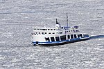
The St. Lawrence River is a large international river in the middle latitudes of North America connecting the Great Lakes to the North Atlantic Ocean. Its waters flow in a northeasterly direction from Lake Ontario to the Gulf of St. Lawrence, traversing Ontario and Quebec in Canada and New York in the United States. A section of the river demarcates the Canada–U.S. border.

<span class="mw-page-title-main">Île d'Orléans</span> Island in the Saint Lawrence River, Quebec, Canada

Île d'Orléans is an island located in the Saint Lawrence River about 5 kilometres (3.1 mi) east of downtown Quebec City, Quebec, Canada. It was one of the first parts of the province to be colonized by the French, and a large percentage of French Canadians can trace ancestry to early residents of the island. The island has been described as the "microcosm of traditional Quebec and as the birthplace of francophones in North America."

<span class="mw-page-title-main">Island of Montreal</span> Island in Quebec, Canada

The Island of Montreal is a large island in southwestern Quebec, Canada, that is the site of a number of municipalities, including most of the city of Montreal, and is the most populous island in Canada. It is the main island of the Hochelaga Archipelago at the confluence of the Saint Lawrence and Ottawa rivers.

<span class="mw-page-title-main">Lake Saint Pierre</span>

Lake Saint Pierre is a lake in Quebec, Canada, a widening of the Saint Lawrence River between Sorel-Tracy and Trois-Rivières. It is located downstream, and northeast, of Montreal; and upstream, and southwest, of Quebec City. The end of the lake delimits the beginning of the estuary of Saint Lawrence.

<span class="mw-page-title-main">Trois-Rivières</span> City in Quebec, Canada

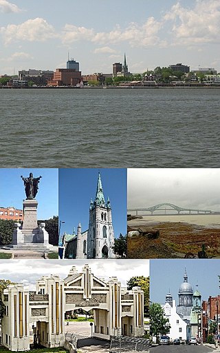
Trois-Rivières is a city in the Mauricie administrative region of Quebec, Canada, at the confluence of the Saint-Maurice and Saint Lawrence rivers, on the north shore of the Saint Lawrence River across from the city of Bécancour. It is part of the densely populated Quebec City–Windsor Corridor and is approximately halfway between Montreal and Quebec City. Trois-Rivières is the economic and cultural hub of the Mauricie region. The settlement was founded by French colonists on July 4, 1634, as the second permanent settlement in New France, after Quebec City in 1608.

<span class="mw-page-title-main">Victoria Bridge (Montreal)</span> Bridge over the St. Lawrence River in Montreal, Quebec

The Victoria Bridge, previously known as Victoria Jubilee Bridge, is a bridge over the St. Lawrence River, linking Montreal, Quebec, to the south shore city of Saint-Lambert.

<span class="mw-page-title-main">Jacques Cartier Bridge</span> Bridge near Montreal, Quebec, Canada

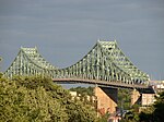
The Jacques Cartier Bridge is a steel truss cantilever bridge crossing the Saint Lawrence River from Montreal Island, Montreal, Quebec, to the south shore at Longueuil, Quebec, Canada. The bridge crosses Saint Helen's Island in the centre of the river, where offramps allow access to the Parc Jean-Drapeau and La Ronde amusement park.

<span class="mw-page-title-main">Quebec Route 138</span> Highway in Quebec

Route 138 is a major highway in the Canadian province of Quebec, following the entire north shore of the Saint Lawrence River past Montreal to the temporary eastern terminus in Kegashka on the Gulf of Saint Lawrence. The western terminus is in Elgin, at the border with New York State south-west of Montreal. Part of this highway is known as the Chemin du Roy, or King's Highway, which is one of the oldest highways in Canada.

<span class="mw-page-title-main">Louis-Hippolyte Lafontaine Bridge–Tunnel</span>

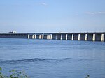
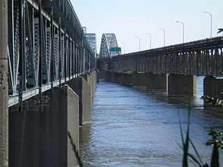
The Louis-Hippolyte Lafontaine Bridge–Tunnel is a highway bridge–tunnel running over and beneath the Saint Lawrence River. It connects the Montreal borough of Mercier–Hochelaga-Maisonneuve with the south shore of the river at Longueuil, Quebec.

<span class="mw-page-title-main">Honoré Mercier Bridge</span> Bridge in Kahnawake and Montreal, Quebec

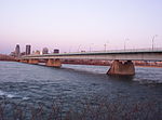
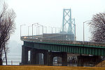
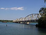
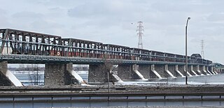
The Honoré Mercier Bridge in Quebec, Canada, connects the Montreal borough of LaSalle on the Island of Montreal with the Mohawk reserve of Kahnawake and the suburb of Châteauguay on the south shore of the Saint Lawrence River. It is the most direct southerly route from the island of Montreal toward the US border. It carries Route 138, originally Route 4. It is 1.361 km (0.846 mi) in length and contains four steel trusses on its first section. The height of the bridge varies from 12.44 m (40.8 ft) to 33.38 m (109.5 ft) with the highest sections located over the St. Lawrence Seaway. The bridge is named after former premier of Quebec Honoré Mercier.

<span class="mw-page-title-main">Jacques-Cartier River</span> River of Capitale-Nationale (Québec, Canada)

The Jacques-Cartier River is a river in the province of Quebec, Canada. It is 161 km long and its source is Jacques-Cartier Lake in Laurentides Wildlife Reserve, and flows in a predominantly southern direction before ending in the Saint Lawrence River at Donnacona, about 30 km upstream from Quebec City.

<span class="mw-page-title-main">Charron Island</span> Island in Quebec, Canada

Charron Island is an island in the Saint Lawrence River, the westernmost of the Îles de Boucherville archipelago, near Îles-de-Boucherville National Park to the northeast of Montreal. It is part of the city of Longueuil, and is connected to the mainland and the Island of Montreal by the Louis-Hippolyte Lafontaine Bridge–Tunnel which carries Quebec Autoroute 25 and the Trans-Canada Highway.

<span class="mw-page-title-main">Montmorency River</span> River in Quebec, Canada

The Montmorency River is a tributary of North-East bank of St. Lawrence river, flowing in the administrative region of Capitale-Nationale, in the province of Quebec, Canada. The course of the river successively crosses the regional county municipality of:

<span class="mw-page-title-main">Archipelago of Saint-Pierre Lake</span>

The Archipelago of Lake Saint Pierre counts 103 islands in the western part of Lake Saint Pierre, in the Canadian province of Quebec. There are two groups: Islands of Berthier to the north and the islands of Sorel to the south.

<span class="mw-page-title-main">Rivière du Cap Rouge</span> River in Quebec, Canada

The Cap-Rouge river is a river flowing on the north shore of the Saint-Laurent river at the height of the Sainte-Foy–Sillery–Cap-Rouge borough of Quebec City and in the city of Saint-Augustin-de-Desmaures, both cities in the administrative region of Capitale-Nationale, in the province of Quebec, Canada.

The rivière aux Pommes is a tributary of the Jacques-Cartier River, flowing in the municipalities of Sainte-Catherine-de-la-Jacques-Cartier, Pont-Rouge, Neuville and Donnacona, in the Portneuf Regional County Municipality, in the administrative region of Capitale-Nationale, in Quebec, Canada.

The Saint-Jacques River is a tributary of the Portneuf River, flowing in the municipalities of Pont-Rouge and Saint-Basile, in the Portneuf Regional County Municipality, in the administrative region of Capitale-Nationale, in the province of Quebec, Canada.

The Rivière du Sud is a tributary of the Richelieu River, flowing successively in the municipalities of Saint-Alexandre, Saint-Sébastien, Clarenceville and Henryville, in the Le Haut-Richelieu Regional County Municipality, in Montérégie, on the south shore of Fleuve Saint-Laurent, in province of Quebec, in Canada.

References

  1. Janberg, Nicolas (2006). "Structurae [fr] - Pont de l'Île d'Orléans" (in French). Structurae (fr). Retrieved 2010-04-06.
  2. Jansberg, Nicolas (2004). "Quebec Bridge". Structurae [en]. Retrieved 2010-04-06.
  3. Jansberg, Nicolas (2006). "Pierre Laporte Bridge". Structurae [en]. Retrieved 2010-04-11.
  4. Jansberg, Nicolas (2004). "Laviolette Bridge". Structurae [en]. Retrieved 2010-04-11.
  5. "Toponymie Trois-Rivières". City of Trois-Rivières. 2010. Archived from the original on 2010-04-10. Retrieved 2010-04-11.
  6. 1 2 "Pont-tunnel Louis-Hippolyte-La Fontaine (40 ans)" (in French). Transports Québec. Archived from the original on 2011-07-16. Retrieved 2009-08-19.
  7. 1 2 "The Jacques Cartier Bridge: History". Jacques Cartier and Champlain Bridges Incorporated. Archived from the original on 2009-07-05. Retrieved 2009-09-14.
  8. "Important dates in STM's history". Société de Transport de Montréal. Archived from the original on 2009-06-21. Retrieved 2009-09-14.
  9. 1 2 3 "Fiche toponymique" (in French). Commission de toponymie du Québec. 2007. Retrieved 2009-08-24.
  10. 1 2 "The Victoria Bridge". City of Montreal. 2003. Retrieved 2009-09-14.
  11. 1 2 "The Champlain Bridge and Bonaventure Expressway". Jacques Cartier and Champlain Bridges Incorporated. Archived from the original on 2010-07-29. Retrieved 2009-09-14.
  12. 1 2 "The Champlain Bridge Ice Control Structure". Les Ponts Jacques-Cartier et Champlain Incorporée. Archived from the original on 2011-06-14. Retrieved 2009-07-20.
  13. 1 2 Les Ponts Jacques-Cartier et Champlain Incorporée. "Histoire du pont Mercier" (in French). Les Ponts Jacques-Cartier et Champlain Incorporée. Archived from the original on 2001-05-25. Retrieved 2009-07-20.
  14. Johansen, Bruce Elliott (1999). The encyclopedia of Native American economic history. Westport, CT: Greenwood Press. p. 166. ISBN   978-0-313-30623-5.
  15. "Fiche toponymique" (in French). Commission de toponymie du Québec. 2009. Retrieved 2010-04-14.
  16. "Fiche toponymique" (in French). Commission de toponymie du Québec. 2009. Retrieved 2010-04-14.
  17. "Fiche toponymique" (in French). Commission de toponymie du Québec. 2009. Retrieved 2010-04-14.
  18. "Fiche toponymique" (in French). Commission de toponymie du Québec. 2009. Retrieved 2010-04-14.
  19. "New Bridge in Cornwall - News - Cornwall Seaway News". Archived from the original on 2014-03-19. Retrieved 2015-06-03.
  20. "Ogdensburg Prescott International Bridge". Nicolas Janberg's Structurae. Retrieved 2009-08-05.
  21. "Thousand Islands Bridge". Digital archives. Canadian Broadcasting Corporation. 1938-08-18. Retrieved 2010-04-13.