Rainbow Bridge (Niagara Falls)

Last updated
Rainbow Bridge
Rainbow Bridge from Niagara Falls Observation Tower.jpeg
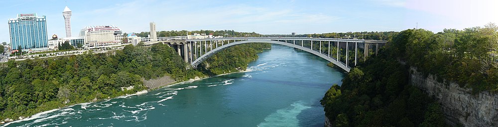
Rainbow Bridge, viewed from Niagara Falls Observation Tower
Coordinates 43°05′25″N79°04′04″W / 43.0902°N 79.0677°W / 43.0902; -79.0677
Carries4 lanes of NY 955A / RR 420 jct blue.svg  Regional Road 420, pedestrian traffic
Crosses Niagara River
Locale Niagara Falls, Ontario, Canada and Niagara Falls, New York, U.S.
Official nameNiagara Falls International Rainbow Bridge
Maintained by Niagara Falls Bridge Commission
Characteristics
Design Arch bridge of steel construction
Total length1,450 ft (440 m) [1]
Height202 ft (62 m) [1]
Longest span960 ft (290 m) [1]
History
Construction cost$4 million [1]
OpenedNovember 1, 1941;82 years ago (1941-11-01)
Statistics
TollCanada-bound only:
$5.00 USD or $6.50 CAD per auto.
$1.00 USD or $1.00 CAD per pedestrian/bicyclist. [2]
Location
Rainbow Bridge (Niagara Falls)

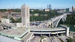
The Niagara Falls International Rainbow Bridge, commonly known as the Rainbow Bridge, is a steel arch bridge across the Niagara River, connecting the cities of Niagara Falls, New York, United States, and Niagara Falls, Ontario, Canada.

Contents

Construction

The Rainbow Bridge was built near the site of the earlier Honeymoon Bridge, which collapsed in 1938 due to an ice jam in the Niagara Gorge.

Architect Richard (Su Min) Lee designed the bridge; a design also used for the Lewiston-Queenston Bridge, approximately 10 kilometres (6 mi) downriver. The bridge's Rainbow Tower and Canadian side plaza are the work of another Canadian architect, William Lyon Somerville. [3] King George VI and Queen Elizabeth, during their visit to Niagara Falls as part of their 1939 royal tour of Canada, dedicated the future construction site of the Rainbow Bridge; a monument was later erected to commemorate the occasion. Construction began in May 1940. The bridge officially opened on November 1, 1941. [4]

The Niagara Falls Bridge Commission chose the name "Rainbow Bridge" in March 1939, because rainbows occur frequently near the falls due to water spray and mist in the air. [5]

Description and specifications

The New York State Department of Transportation designates the bridge as NY 955A, an unsigned reference route. Roads that adjoin the bridge include New York routes 104 and 384, and the Niagara Scenic Parkway. The Ontario Ministry of Transportation designates the bridge as part of Highway 420. The Rainbow Tower, part of the plaza complex on the Canadian side, houses a carillon, which plays several times daily.

The Rainbow Bridge does not permit commercial trucks; the nearest border crossing accessible to trucks is the Lewiston-Queenston Bridge. [6]

For each pedestrian or bicyclist, the toll to cross the bridge is $1.00 USD or CAD. For vehicles, the toll is only collected when leaving the United States and entering Canada. As of August 2022, the cash toll for personal vehicles is $5.00 USD or $6.50 CAD. [2]

2023 car crash

On November 22, 2023, a car traveling at a high rate of speed left the roadway, went airborne, crashed and exploded at the Rainbow Bridge border crossing on the American side. The vehicle's two occupants died, and a U.S. Customs and Border Protection officer was injured. [7] The crash and subsequent explosion was at first investigated as a potential terrorist attack, and was later determined to have been an unintentional crash. [8]

Rainbow Bridge.jpg
Rainbow Bridge (Canada on left)

See also

Related Research Articles

<span class="mw-page-title-main">Niagara River</span> River in New York, United States and Ontario, Canada

The Niagara River flows north from Lake Erie to Lake Ontario, forming part of the border between Ontario, Canada, to the west, and New York, United States, to the east. The origin of the river's name is debated. Iroquoian scholar Bruce Trigger suggests it is derived from a branch of the local Neutral Confederacy, referred to as the Niagagarega people on several late-17th-century French maps. George R. Stewart posits that it comes from an Iroquois town named Ongniaahra, meaning "point of land cut in two."

<span class="mw-page-title-main">Niagara Falls</span> Waterfalls between United States and Canada

Niagara Falls is a group of three waterfalls at the southern end of Niagara Gorge, spanning the border between the province of Ontario in Canada and the state of New York in the United States. The largest of the three is Horseshoe Falls, which straddles the international border of the two countries. It is also known as the Canadian Falls. The smaller American Falls and Bridal Veil Falls lie within the United States. Bridal Veil Falls is separated from Horseshoe Falls by Goat Island and from American Falls by Luna Island, with both islands situated in New York.

<span class="mw-page-title-main">Lewiston (village), New York</span> Village in New York, United States

Lewiston is a village in Niagara County, New York, United States. The population was 2,701 at the 2010 census. The village is named after Morgan Lewis, an early 19th-century governor of New York. It is part of the Buffalo–Niagara Falls Metropolitan Statistical Area.

<span class="mw-page-title-main">Queenston</span> Community in Ontario, Canada

Queenston is a compact rural community and unincorporated place 5 kilometres (3.1 mi) north of Niagara Falls in the Town of Niagara-on-the-Lake, Ontario, Canada. It is bordered by Highway 405 to the south and the Niagara River to the east; its location at the eponymous Queenston Heights on the Niagara Escarpment led to the establishment of the Queenston Quarry in the area. Across the river and the Canada–US border is the village of Lewiston, New York. The Lewiston-Queenston Bridge links the two communities. This village is at the point where the Niagara River began eroding the Niagara Escarpment. During the ensuing 12,000 years the Falls cut an 11 kilometres (6.8 mi) long gorge in the Escarpment southward to its present-day position.

<span class="mw-page-title-main">Lewiston–Queenston Bridge</span> Bridge in Ontario and Lewiston, New York

The Lewiston–Queenston Bridge, also known as the Queenston–Lewiston Bridge, is an arch bridge that crosses the Niagara River gorge just south of the Niagara Escarpment. The bridge was officially opened on November 1, 1962. It is an international bridge between the United States and Canada. It connects Interstate 190 in the town of Lewiston, New York to Highway 405 in the community of Queenston, Ontario. The Lewiston–Queenston Bridge is architecturally similar to the Rainbow Bridge at nearby Niagara Falls.

<span class="mw-page-title-main">Whirlpool Rapids Bridge</span> Bridge in Ontario and New York

The Whirlpool Rapids Bridge, commonly known as the Whirlpool Bridge or the Lower Steel Arch Bridge, is a spandrel braced, riveted, two-hinged arch bridge that crosses the Canada–United States border, connecting the commercial downtown districts of Niagara Falls, Ontario, and Niagara Falls, New York. This bridge is located approximately 1.5 kilometres (0.9 mi) north of the Rainbow Bridge and about 2 kilometres (1.2 mi) from the Falls. It was acquired by the Niagara Falls Bridge Commission in January 1959. Immediately upstream is the similar arch-style Michigan Central Railway Bridge, which has been out of service since 2001.

<span class="mw-page-title-main">Peace Bridge</span> Truss arch bridge connecting US to Canada

The Peace Bridge is an international bridge over the Niagara River between Canada and the United States, located just north of the river's source at the east end of Lake Erie about 20 kilometres (12.4 mi) upriver of Niagara Falls. It connects Buffalo, New York, in the United States to Fort Erie, Ontario, in Canada. It is operated and maintained by the bi-national Buffalo and Fort Erie Public Bridge Authority.

King's Highway 405, also known as Highway 405 and the General Brock Parkway, is a 400-Series Highway in the Canadian province of Ontario connecting the Queen Elizabeth Way (QEW) near St. Catharines with the Lewiston–Queenston Bridge in the village of Queenston. It then crosses the Niagara River, where it encounters the international border with the United States and continues into New York as Interstate 190 (I-190).

King's Highway 420, commonly referred to as Highway 420, is a 400-series highway in the Canadian province of Ontario that connects the Queen Elizabeth Way (QEW) with downtown Niagara Falls. It continues east as a limited-access expressway named Niagara Regional Road 420 to connect with the Rainbow Bridge international crossing between Canada and the United States over the Niagara River; this was part of Highway 420 until 1998. West of the QEW, the freeway ends at an at-grade intersection with Montrose Road. The highway has a speed limit of 80 kilometres per hour (50 mph), making it the only 400-series highway to have a speed limit less than 100 kilometres per hour (62 mph) for its entirety.

<span class="mw-page-title-main">Interstate 190 (New York)</span> Highway in New York

Interstate 190 is a north–south auxiliary Interstate Highway in the United States that connects I-90 in Buffalo, New York, with the Canada–United States border at Lewiston, New York, near Niagara Falls. Officially, I-190 from I-90 north to New York State Route 384 (NY 384) is named the Niagara Thruway and is part of the New York State Thruway system. The remainder, from NY 384 to Lewiston, is known as the Niagara Expressway and is maintained by the New York State Department of Transportation (NYSDOT).

<span class="mw-page-title-main">Niagara Gorge</span> Canyon on the border between New York, USA and Ontario, Canada

Niagara Gorge is an 11 km (6.8 mi) long canyon carved by the Niagara River along the Canada–United States border, between the U.S. state of New York and the Canadian province of Ontario. It begins at the base of Niagara Falls and ends downriver at the edge of the geological formation known as the Niagara Escarpment near Queenston, Ontario, where the falls originated about 12,500 years ago. The position of the falls has receded upstream toward Lake Erie because of the falling waters' slow erosion of the riverbed's hard Lockport dolomite, combined with rapid erosion of the relatively soft layers beneath it. This erosion has created the gorge.

The Buffalo and Fort Erie Public Bridge Authority is the agency established to regulate the Peace Bridge, which crosses the Canada–United States border. This bridge is designed to handle vehicle traffic between Buffalo in the American state of New York and Fort Erie in the Canadian province of Ontario.

The Niagara Falls Bridge Commission is an international public agency which administers three international bridges across the Niagara River connecting the province of Ontario, Canada, and the state of New York, United States: the Lewiston–Queenston Bridge, Whirlpool Rapids Bridge and Rainbow Bridge. The NFBC is incorporated as a class D New York State public benefit corporation and is licensed to operate in Ontario under the Extra-Provincial Corporations Act. The commission is based in Lewiston, New York, and maintains a post office box address in Niagara Falls, Ontario. It is mostly self-supporting from tolls, leases, and commercial concessions.

<span class="mw-page-title-main">Great Gorge Route</span> Trolley line through the Niagara Gorge, New York, United States

The Great Gorge Route or Niagara Belt Line was an interurban trolley belt line encompassing the Niagara Gorge, operated by the International Railway and Niagara Gorge Railroad. Many dignitaries rode this line and they used to use a flat car with search light to illuminate the Niagara Whirlpool at night.

<span class="mw-page-title-main">Michigan Central Railway Bridge</span> Bridge in Ontario and Niagara Falls, New York

The Michigan Central Railway Bridge is an out-of-service steel Deck arch bridge spanning the Niagara Gorge between Niagara Falls, Ontario and Niagara Falls, New York. The bridge is owned by Canadian Pacific Kansas City, which purchased the single track structure in 1990. The Canadian corridor and bridge are owned by the City of Niagara Falls, Ontario. The bridge is located just upstream from the older arch-style Whirlpool Rapids Bridge used by Maple Leaf Amtrak passenger trains.

The Niagara Parkway, formerly known as Niagara Boulevard and historically as the Niagara Road, is a scenic road in the province of Ontario that travels on the Canadian side of the Niagara River from the town of Fort Erie to Niagara-on-the-Lake. The portion north of Table Rock in the city of Niagara Falls is designated as an Ontario Scenic Highway. Niagara Boulevard originally referred only to the section from Fort Erie to Chippawa.

<span class="mw-page-title-main">Niagara Gorge Railroad</span> Railway line in New York state, 1895–1935

The Niagara Gorge Railroad was an interurban railway which ran at the bottom of the Niagara Gorge from Niagara Falls, New York to Lewiston, New York.

<span class="mw-page-title-main">Fort Frances–International Falls International Bridge</span> Bridge in Fort Frances, Ontario

The Fort Frances–International Falls International Bridge is a privately owned international toll bridge connecting the towns of Fort Frances, Ontario, and International Falls, Minnesota, across the Rainy River.

References

  1. 1 2 3 4 "Celebrating Eight Decades of Award-winning Bridges" (PDF). Modern Steel Construction. American Institute of Steel Construction. November 2011. p. 23 (page 2 in PDF). Retrieved April 30, 2019.
  2. 1 2 "Niagara Falls Bridge Commission: Toll Cost & Vehicle Definitions". August 1, 2022. Retrieved 2023-09-24.
  3. "Somerville, William Lyon". Biographical Dictionary of Architects in Canada 1800–1950. Retrieved August 23, 2017.
  4. Woyce, Kevin (2015). Niagara: The Falls and the River: An Illustrated History. Kevin Woyce. ISBN   978-0692522523.
  5. Stamp, Robert M. (1992). Bridging the Border: Structures of Canadian–American Relations. Toronto: Dundurn Press. p. 128. ISBN   1-55002-074-9.
  6. "Niagara Falls Bridge Commission: Which Bridge Do I Take?".
  7. Tabachnick, Cara (2023-11-24). "2 dead in vehicle explosion at Rainbow Bridge U.S.-Canada border crossing; officials say no sign of terrorism". CBS News . Retrieved 2023-11-25.
  8. Tebor, Celina; Miller, John; Perez, Evan; Sanchez, Ray (2023-11-23). "Sources: Deadly crash at US-Canadian border bridge involved husband and wife in a Bentley, investigators believe". CNN . Retrieved 2024-01-11. He called the crash a "tragic accident."

43°5′24.84″N79°4′3.88″W / 43.0902333°N 79.0677444°W / 43.0902333; -79.0677444