
The Niagara River is a river that flows north from Lake Erie to Lake Ontario. It forms part of the border between the province of Ontario in Canada and the state of New York in the United States. There are differing theories as to the origin of the river's name. According to Iroquoian scholar Bruce Trigger, Niagara is derived from the name given to a branch of the locally residing native Neutral Confederacy, who are described as being called the Niagagarega people on several late-17th-century French maps of the area. According to George R. Stewart, it comes from the name of an Iroquois town called Ongniaahra, meaning "point of land cut in two".
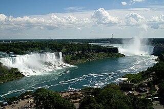
Niagara Falls is a group of three waterfalls at the southern end of Niagara Gorge, spanning the border between the province of Ontario in Canada and the state of New York in the United States. The largest of the three is Horseshoe Falls, which straddles the international border of the two countries. It is also known as the Canadian Falls. The smaller American Falls and Bridal Veil Falls lie within the United States. Bridal Veil Falls is separated from Horseshoe Falls by Goat Island and from American Falls by Luna Island, with both islands situated in New York.

The American Falls is the second largest of the three waterfalls that together are known as Niagara Falls on the Niagara River along the Canada–United States border. Unlike the much larger Horseshoe Falls, of which approximately 90% is in Ontario, Canada, and 10% in the U.S. state of New York, the American Falls is entirely within the United States.
Bridal Veil Falls, Bridalveil Falls or Bridalveil Fall is a frequently-used name for waterfalls that observers fancy resemble a bride's veil:

Horseshoe Falls is the largest of the three waterfalls that collectively form Niagara Falls on the Niagara River along the Canada–United States border. Approximately 90% of the Niagara River, after diversions for hydropower generation, flows over Horseshoe Falls. The remaining 10% flows over American Falls and Bridal Veil Falls. It is located between Terrapin Point on Goat Island in the US state of New York, and Table Rock in the Canadian province of Ontario. These falls are also referred to as the Canadian Falls.

Niagara Falls is a city in Niagara County, New York, United States. As of the 2020 census, the city had a total population of 48,671. It is adjacent to the Niagara River, across from the city of Niagara Falls, Ontario, and named after the famed Niagara Falls which they share. The city is within the Buffalo–Niagara Falls metropolitan area and the Western New York region.

Niagara Falls State Park is located in the City of Niagara Falls in Niagara County, New York, United States. The park, recognized as the oldest state park in the United States, contains the American Falls, the Bridal Veil Falls, and a portion of the Horseshoe Falls.

Bridal Veil Falls Provincial Park is a BC Park located on the Trans-Canada Highway just east of Rosedale, British Columbia, Canada, part of the City of Chilliwack. The community of Bridal Falls is located adjacent to the falls and park as well as the interchange between the Trans-Canada and BC Highway 9 and has a variety of highway-based tourism services. Access to the falls requires a short hike from the parking lot and well groomed trails, taking most groups 15-25 minutes.
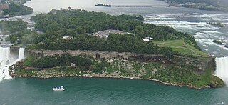
Goat Island is a small island in the Niagara River, in the middle of Niagara Falls between the Bridal Veil Falls and the Horseshoe Falls. The island is at the southwest corner of the City of Niagara Falls, New York, in the United States and is part of Niagara Falls State Park.
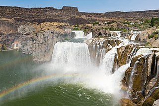
Shoshone Falls is a waterfall in the western United States, on the Snake River in south-central Idaho, approximately three miles (5 km) northeast of the city of Twin Falls. Sometimes called the "Niagara of the West," Shoshone Falls is 212 feet (65 m) in height, 45 feet (14 m) higher than Niagara Falls, and flows over a rim nearly one thousand feet (300 m) in width.


Niagara Gorge is an 11 km (6.8 mi) long canyon carved by the Niagara River along the Canada–United States border, between the U.S. state of New York and the Canadian province of Ontario. It begins at the base of Niagara Falls and ends downriver at the edge of the geological formation known as the Niagara Escarpment near Queenston, Ontario, where the falls originated about 12,500 years ago. The position of the falls has receded upstream toward Lake Erie because of the falling waters' slow erosion of the riverbed's hard Lockport dolomite, combined with rapid erosion of the relatively soft layers beneath it. This erosion has created the gorge.

The Bridal Veil Falls is a waterfall located on Bridal Veil Creek along the Columbia River Gorge in Multnomah County, Oregon, United States. The waterfall is accessible from the historic Columbia River Highway and Interstate 84. Spanning two tiers on basalt cliffs, it is the only waterfall which occurs below the historic Columbia Gorge Scenic Highway. The Bridal Veil Falls Bridge, built in 1914, crosses over the falls, and is listed on the National Register of Historic Places.

The International Railway Bridge is a two-span swing bridge carrying the Stamford Subdivision of the Canadian National Railway across the Niagara River between Fort Erie, Ontario, Canada, and Buffalo, New York, United States. It was originally built in 1873 for the International Bridge Company by Casimir Stanislaus Gzowski and D.L. MacPherson.

Bridal Veil Falls is a 365-foot waterfall at the end of the box canyon overlooking Telluride, Colorado. Hiking and off-road trails pass by the falls and it has a hydroelectric power plant at its top. In winter the frozen shape of the falls forms an imposing challenge to intrepid ice climbers.

The Pakoka River is a river of the Waikato Region of New Zealand's North Island. It flows southwest from its source southeast of Raglan to reach the northeastern end of the Aotea Harbour. The catchment is made up of just over 86 kilometres (53 mi) of waterways.

The Niagara Whirlpool is a natural whirlpool within the Niagara River located along the Canada–U.S. border between New York and Ontario. The whirlpool is in the Niagara Gorge, downstream from Niagara Falls. The whirlpool's greatest depth is 125 feet (38 m).

The geology of Ontario is the study of rock formations in the most populated province in Canada- it is home to some of the oldest rock on Earth. The geology in Ontario consists of ancient Precambrian igneous and metamorphic rock which sits under younger, sedimentary rocks and soils.


