Fort Erie is one of Niagara's fastest growing communities, and has experienced a high level of residential and commercial development in the past few years. Garrison Road (Niagara Regional Road 3) is the town's commercial corridor, stretching east to west through Fort Erie.
Fort Erie is also home to other commercial core areas (Bridgeburg, Ridgeway, Stevensville and Crystal Beach) as a result of the 1970 amalgamation of Bertie Township and the village of Crystal Beach with Fort Erie.
During the American Revolution Fort Erie was used as a supply depot for British troops. After the war the territory of what is now the Town of Fort Erie was settled by soldiers demobilised from Butler's Rangers, and the area was named Bertie Township in 1784.
The original fort, built in 1764, was located on the Niagara River's edge below the present fort. It served as a supply depot and a port for ships transporting merchandise, troops and passengers via Lake Erie to the Upper Great Lakes.[3] The fort was damaged by winter storms and in 1803, plans were made for a new fort on the higher ground behind the original. It was larger and made of flintstone but was not quite finished at the start of the War of 1812.[3]
During the war, the Americans attacked Fort Erie twice in 1812, captured and abandoned it in 1813, and then recaptured it in 1814. The Americans held it for a time, breaking a prolonged British siege. Later they destroyed Fort Erie and returned to Buffalo in the winter of 1814.
Map of various Underground Railroad routes
The Fort Erie area became a major terminus for slaves using the Underground Railroad (between 1840 and 1860); many had crossed into Canada from Buffalo, New York. Bertie Hall (which was used for a time in the 20th century as a Doll House Museum) may have been a stopping point on the Underground Railroad.[4][5] The area of Ridgemount was one of the three main areas in Fort Erie settled by African-Americans, earning it the name "Little Africa".[6] Along with Little Africa, the other two areas of settlement were Bertie Hill and Snake Hill (Erie Beach).
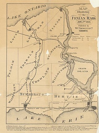
In 1866, during the Fenian raids, between 1,000 and 1,500 Fenians crossed the Niagara River, occupied the town and demanded food and horses. The only payment they were able to offer was Fenian bonds; these were not acceptable to the citizens. The Fenians then cut the telegraph wires and tore up some railway tracks. Afterwards, they marched to Chippewa and the next day to Ridgeway where they fought the Battle of Ridgeway, a series of skirmishes with the Canadian militia.[7] The Fenians then returned to Fort Erie and fought the Battle of Fort Erie, defeating the Canadian militia. Fearing British reinforcements, they then decided to retreat to the U.S.[8][9]
In 1869 the population was 1,000 and Fort Erie was served by the Grand Trunk and the Erie & Niagara railways. The Grand Trunk Railway built the International Railway Bridge in 1873, bringing about a new town, originally named Victoria and subsequently renamed to Bridgeburg, north of the original settlement of Fort Erie. By 1876, Ridgeway had an estimated population of 800, the village of Fort Erie has an estimated population of 1,200, and Victoria boasted three railway stations.[10] By 1887, Stevensville had an estimated population of "nearly 600", Victoria of "nearly 700", Ridgeway of "about 600", and Fort Erie of "about 4,000".[11]
In 1888, the amusement park at Crystal Beach opened. From 1910, the steamship Canadiana (and until 1929, the steamship SS Americana) brought patrons from Buffalo until 1956. The park continued to operate until it closed in 1989. A gated community was built in this area.[12][13]
Founders of the Niagara Movement in Fort Erie.
In 1904, a group of speculators bought land at Erie Beach, planning to build an amusement park and other amenities, and sell lots around the park to vacationers from Buffalo. Erie Beach featured a hotel, a casino, a race track, regular ferry service from Buffalo and train service from the ferry dock in Fort Erie, and what was billed as the world's largest outdoor swimming pool. Erie Beach and Crystal Beach were in competition to provide bigger thrills to patrons, until Erie Beach went bankrupt during the Depression and closed down on Labour Day weekend, 1930.[14]
The Niagara Movement meeting was held at the Erie Beach Hotel[15] in 1905. The movement later led to the founding of the NAACP.
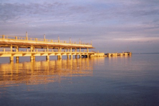
The Point Abino Light Tower was built by the Canadian government in 1918. The lighthouse has been automated in 1989. Since its decommissioning in 1995, the Point Abino Lighthouse was designated as a National Historic Site. The lighthouse is now owned by the Town of Fort Erie and is available for weekend tours in the summer.
On August 7, 1927, the Peace Bridge was opened between Fort Erie and Buffalo.
On January 1, 1932, Bridgeburg and Fort Erie amalgamated into a single town.
The ruins of Fort Erie remained until they were rebuilt through a depression era "work program" project, as a tourist attraction. Work started in 1937, and the fort was opened to the public in 1939.
In 1970, the provincial government consolidated the various villages in what had been Bertie Township, including the then town of Fort Erie, into the present Town of Fort Erie.
Geography
Fort Erie is generally flat, but there are low sand hills, varying in height from 2 to 15 metres (6.6 to 49.2ft), along the shore of Lake Erie, and a limestone ridge extends from Point Abino to near Miller's Creek, giving Ridgeway its name. The soil is shallow, with a clay subsoil.
The town's beaches on Lake Erie, most notably Erie Beach, Crystal Beach and Bay Beach are considered the best in the area and draw many weekend visitors from the Toronto and Buffalo, New York areas. While summers are enjoyable, winters can occasionally be fierce, with many snowstorms, whiteouts and winds coming off Lake Erie.
Communities
In addition to the primary urban core of Fort Erie, the town also contains the neighbourhoods of Black Creek, Bridgeburg/NorthEnd/Victoria, Crescent Park, Crystal Beach, Kraft, Point Abino, Ridgeway, Snyder, and Stevensville. Smaller and historical neighbourhoods include Amigari Downs, Bay Beach, Buffalo Heights, Douglastown, Edgewood Park, Erie Beach, Garrison Village, Mulgrave, Oakhill Forest, Ridgemount, Ridgewood, Rose Hill Estates, Thunder Bay, Walden, Wavecrest and Waverly Beach.
Fort Erie Secondary School and Ridgeway-Crystal Beach High School were two public high schools serving Fort Erie and area communities until September 2017. The two former schools were closed and merged into Greater Fort Erie Secondary School, located on Garrison Road.[16]
In the 2021 Census of Population conducted by Statistics Canada, Fort Erie had a population of 32,901 living in 14,081 of its 15,875 total private dwellings, a change of 7.1% from its 2016 population of 30,710. With a land area of 166.24km2 (64.19sqmi), it had a population density of 197.9/km2 (512.6/sqmi) in 2021.[18]
The median household income in 2015 for Fort Erie was $60,800, which was below the Ontario provincial average of $74,287.[19]
Mather Arch Park, located just to the south of the Peace Bridge, is on land donated by American citizen Alonzo C. Mather in tribute to the peace and friendship between Canada and the United States. The park contains Mather Arch, which was built largely due to donations by Mather, originally dedicated by the Niagara Parks Commission in 1939, and restored in 2000 as a millennium project. There is also a memorial statue to those from Fort Erie who died in World War I, World War II, and the Korean War.[23]
Fort Erie has been the Niagara terminus of the Queen Elizabeth Way since 1937. Road traffic continues to Buffalo, New York across the Peace Bridge, which was built in 1927.
Fort Erie was the eastern terminus of King's Highway 3A from 1927 to 1929, and Ontario Highway 3 from 1929 until 1998, when the portion of Highway 3 within Fort Erie was downloaded to the Regional Municipality of Niagara and redesignated as Niagara Regional Road 3. Within Fort Erie, Highway 3 is named Garrison Road, and is the major east–west connection through the town. Dominion Road was designated as King's Highway 3C from 1934 until 1970, when it was downloaded to the newly formed Regional Municipality of Niagara and redesignated as Niagara Regional Road 1.
Private intercity coach services are primarily operated by Coach Canada/Megabus, with service to St. Catharines and Toronto. The terminus is located at Robo Mart, 21 Princess Street at Waterloo Street.
Fort Erie is at the outlet of Lake Erie into the Niagara River. The lake and river serve as a playground for numerous personal yachts, sailboats, power boats and watercraft. There is a marina at the site of a former shipyard at Miller's Creek on the Niagara River, and a boat launch ramp in Crystal Beach.
Prior to the completion of the two bridges, passengers and freight were carried across the river by ferry.
From 1829, when the Welland Canal first opened, to 1833, when the cut was completed to Port Colborne, ship traffic between Lake Erie and Lake Ontario would transit the upper Niagara River.
Utilities
In order to reduce large-scale ice blockage in the Niagara River, with resultant flooding, ice damage to docks and other waterfront structures, and blockage of the water intakes for the hydro-electric power plants at Niagara Falls, the New York Power Authority and Ontario Power Generation have jointly operated the Lake Erie-Niagara River Ice Boom since 1964. The boom is installed on December 16, or when the water temperature reaches 4°C (39°F), whichever happens first. The boom is opened on April 1 unless there is more than 650 square kilometres (250sqmi) of ice remaining in Eastern Lake Erie. When in place, the boom stretches 2,680 metres (8,790ft) from the outer breakwall at Buffalo Harbor almost to the Canadian shore near the ruins of the pier at Erie Beach in Fort Erie. Originally, the boom was made of wooden timbers, but these have been replaced by steel pontoons.[26]
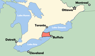
The Niagara River is a river that flows north from Lake Erie to Lake Ontario. It forms part of the border between the province of Ontario in Canada and the state of New York in the United States. There are differing theories as to the origin of the river's name. According to Iroquoian scholar Bruce Trigger, Niagara is derived from the name given to a branch of the locally residing native Neutral Confederacy, who are described as being called the Niagagarega people on several late-17th-century French maps of the area. According to George R. Stewart, it comes from the name of an Iroquois town called Ongniaahra, meaning "point of land cut in two".
Grand Island is an island town in Erie County, New York, United States. As of the 2020 census, the town's population was 21,389 representing an increase of 5.00% from the 2010 census figure. The town's name is derived from the French name La Grande Île; Grand Island is the largest island in the Niagara River and the third largest in New York state. The phrase La Grande Île appears on the town seal.
Youngstown is a village in Niagara County, New York, United States. The population was 1,935 at the 2010 census. It is part of the Buffalo–Niagara Falls Metropolitan Statistical Area.
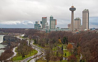
Niagara Falls is a city in Ontario, Canada. It is on the western bank of the Niagara River in the Golden Horseshoe region of Southern Ontario, with a population of 94,415 at the 2021 census. It is part of the St. Catharines - Niagara Census Metropolitan Area (CMA). Incorporated on 12 June 1903, the city is across the river from Niagara Falls, New York. The Niagara River flows over Niagara Falls at this location, creating a natural spectacle which attracts millions of tourists each year.
The Niagara Peninsula is an area of land lying between the southwestern shore of Lake Ontario and the northeastern shore of Lake Erie, in Ontario, Canada. Technically an isthmus rather than a peninsula, it stretches from the Niagara River in the east to Hamilton, Ontario, in the west. The peninsula is located in the Golden Horseshoe region of Southern Ontario, and has a population of roughly 1,000,000 residents. The region directly across the Niagara River and Lake Erie in New York State is known as the Niagara Frontier.
The Regional Municipality of Niagara, also colloquially known as the Niagara Region or Region of Niagara, is a regional municipality comprising twelve municipalities of Southern Ontario, Canada. The regional seat is in Thorold. It is the southern end of the Golden Horseshoe, the largest megalopolis in Canada.
Old Fort Erie, also known as Fort Erie, or the Fort Erie National Historic Site of Canada, was the first British fort to be constructed as part of a network developed after the Seven Years' War was concluded by the Treaty of Paris (1763), at which time France ceded its territories east of the Mississippi River to Great Britain. The installation is located on the southern edge of what is now the Town of Fort Erie, Ontario, directly across the Niagara River from Buffalo, New York, United States.
The Fenian raids were a series of incursions carried out by the Fenian Brotherhood, an Irish republican organization based in the United States, on military fortifications, customs posts and other targets in Canada in 1866, and again from 1870 to 1871. A number of separate incursions by the Fenian Brotherhood into Canada were undertaken to bring pressure on the British government to withdraw from Ireland, although none of these raids achieved their aims.
Ridgeway is a small, unincorporated village in Fort Erie, Ontario, Canada. The community is within the Niagara Regional Municipality. It used to be the seat of government for Bertie Township within Welland County. Ridgeway is now a part of the Town of Fort Erie. In recent years the rail line has been converted to a walking and cycling trail, part of a trail system circling the Niagara region.
The Battle of Ridgeway was fought in the vicinity of the town of Fort Erie across the Niagara River from Buffalo, New York, near the village of Ridgeway, Canada West, currently Ontario, Canada, on June 2, 1866, between Canadian troops and an irregular army of Irish-American invaders, the Fenians. It was the largest engagement of the Fenian Raids, the first modern industrial-era battle to be fought by Canadians and the first to be fought only by Canadian troops and led exclusively by Canadian officers. The battlefield was designated a National Historic Site of Canada in 1921 and is the last battle fought within the current boundaries of Ontario against a foreign invasion. The action at Ridgeway has the distinction of being the only armed victory for the cause of Irish independence between the Irish Rebellion of 1798 and the Easter Rising in 1916.
Welland County is a historic county in the Canadian province of Ontario.
Crystal Beach is a lakefront community in Fort Erie, Ontario, Canada. As of 2016, it had a population of 8,524. It was named for the "crystal clear" water conditions present when it was founded on the northeast shore of Lake Erie, across from Buffalo.
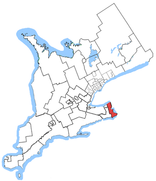
Niagara Falls is a federal electoral district in Ontario, Canada, that has been represented in the House of Commons of Canada since 1953.
The Battle of Fort Erie was a surrounding and forcing of the Fenian armies surrender following a skirmish near Fort Erie and the farther away Battle of Ridgeway on June 2, 1866. The Fenian force, withdrawing from Ridgeway, met a small force of Canadian militia at Fort Erie, then known as the village of Waterloo.
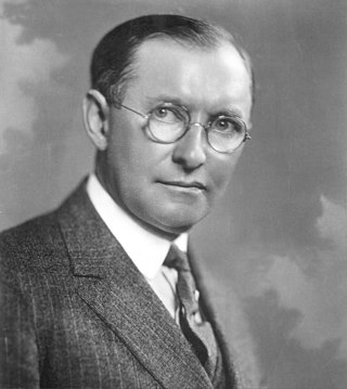
James Lewis Kraft was a Canadian-American entrepreneur and inventor and the founder of Kraft Foods Inc. Kraft immigrated to the United States from Canada in 1902. He developed a patented pasteurization process for cheese, allowing it to be shipped long distances, making him the first to patent processed cheese.
Stevensville is a small community in southern Ontario, Canada in the town of Fort Erie, most notable as the birthplace of Canadian entrepreneur James L. Kraft.
The Great Lakes Seaway Trail, formerly named and commonly known as the Seaway Trail, is a 518-mile (834 km) National Scenic Byway in the northeastern United States, mostly contained in New York but with a small segment in Pennsylvania. The trail consists of a series of designated roads and highways that travel along the Saint Lawrence Seaway—specifically, Lake Erie, the Niagara River, Lake Ontario, and the Saint Lawrence River. It begins at the Ohio state line in rural Erie County, Pennsylvania, and travels through several cities and villages before ending at the Seaway International Bridge northeast of the village of Massena in St. Lawrence County, New York. It is maintained by the non-profit Seaway Trail, Inc.
Fort Erie Transit used to provide local accessible bus service to the inhabitants of Fort Erie, Ontario, Canada, just across the Peace Bridge and the Niagara River from Buffalo, New York.
Transportation in Buffalo, New York is dominated by automobile use, but other modes of transportation exist in the city.
The Point Abino Light Tower is a lighthouse on the rocky north shore of Lake Erie at the southern tip of Point Abino peninsula west of Crystal Beach, Ontario, Canada. The Greek Revival white square tower with red accents is attached to the fog alarm building, and a lighthouse keeper's residence is located on the shore to the north.
↑ "The Fenian Raid 1866". The Queen's Own Rifles of Canada Regimental Museum and Archives. 23 February 2012. Retrieved 7 September 2017.
↑ For the figure of 850, see: H.W. Hemans to Lord Monck, telegram June 3, 1866, in [s.n.] Correspondence Relating to the Fenian Invasion and Rebellion of the Southern States, Ottawa: 1869. p. 142; also Colonel Lowry, Report, June 4, 1866, Miscellaneous Records Relating to the Fenian Raids, British Military and Naval Records "C" Series, RG8-1, Volume 1672; Microfilm reel C-4300, p. 282. (Public Archives of Canada)
This page is based on this Wikipedia article Text is available under the CC BY-SA 4.0 license; additional terms may apply. Images, videos and audio are available under their respective licenses.