Ridgeville, Ontario

Last updated
Ridgeville
Unincorporated community
Ridgeville, Ontario.jpg
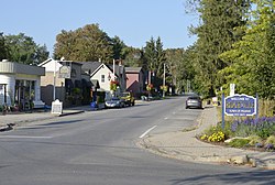
Looking west on Canboro Road in Ridgeville
Ridgeville, Ontario
Coordinates: 43°2′15″N79°18′40″W / 43.03750°N 79.31111°W / 43.03750; -79.31111
Country Canada
Province Ontario
Regional municipality Niagara
Town Pelham
Time zone UTC-5 (EST)
  Summer (DST) UTC-4 (EDT)
Forward sortation area
Area codes 905 and 289
NTS Map 30M3 Niagara
GNBC CodeFCLBD

Ridgeville is a community within the town of Pelham, Ontario, in Canada. It borders the western limit of Fonthill. It derives its name from its location on the south western ridge of the Fonthill Kame. It has a post office, a rural mail route named Ridgeville, a small number of shops found along Canboro Road, including a bakery, chocolate shop and specialty home and bath shops, the local high school, Gwennol Organic Blueberry Farm and the Ridge Berry Farm Tea Room.

Contents

It is located on what was formerly known as traditional Neutral, Haudenosaunee, and Anishnaabe territory.

Climate

The climate is warm-summer humid continental (Köppen: Dfb). [1] The community serves as the basis for Pelham's normals. [2]

Climate data for Ridgeville, elevation: 236.2 m or 775 ft, 1981-2010 normals, extremes 1950-2006
MonthJanFebMarAprMayJunJulAugSepOctNovDecYear
Record high °C (°F)17.0
(62.6)
19.5
(67.1)
26.0
(78.8)
32.0
(89.6)
33.0
(91.4)
33.0
(91.4)
35.5
(95.9)
35.0
(95.0)
33.9
(93.0)
29.4
(84.9)
25.0
(77.0)
20.0
(68.0)
35.5
(95.9)
Mean daily maximum °C (°F)−1.3
(29.7)
0.0
(32.0)
4.5
(40.1)
11.8
(53.2)
18.5
(65.3)
23.4
(74.1)
26.0
(78.8)
25.0
(77.0)
20.9
(69.6)
14.1
(57.4)
7.8
(46.0)
1.7
(35.1)
12.7
(54.9)
Daily mean °C (°F)−4.4
(24.1)
−3.3
(26.1)
0.7
(33.3)
7.3
(45.1)
13.6
(56.5)
18.9
(66.0)
21.7
(71.1)
20.9
(69.6)
16.9
(62.4)
10.5
(50.9)
4.7
(40.5)
−1.2
(29.8)
8.9
(47.9)
Mean daily minimum °C (°F)−7.5
(18.5)
−6.7
(19.9)
−3.1
(26.4)
2.7
(36.9)
8.6
(47.5)
14.3
(57.7)
17.4
(63.3)
16.7
(62.1)
12.9
(55.2)
6.9
(44.4)
1.6
(34.9)
−4.0
(24.8)
5.0
(41.0)
Record low °C (°F)−25.5
(−13.9)
−24.4
(−11.9)
−21.0
(−5.8)
−11.7
(10.9)
−3.5
(25.7)
2.8
(37.0)
5.0
(41.0)
5.0
(41.0)
1.1
(34.0)
−3.9
(25.0)
−12.2
(10.0)
−26.0
(−14.8)
−26.0
(−14.8)
Average precipitation mm (inches)67.1
(2.64)
53.6
(2.11)
64.2
(2.53)
77.7
(3.06)
89.2
(3.51)
84.7
(3.33)
83.6
(3.29)
77.6
(3.06)
92.6
(3.65)
86.3
(3.40)
90.7
(3.57)
78.9
(3.11)
946.2
(37.26)
Average rainfall mm (inches)32.7
(1.29)
30.9
(1.22)
45.2
(1.78)
72.3
(2.85)
88.7
(3.49)
84.7
(3.33)
83.6
(3.29)
77.6
(3.06)
92.6
(3.65)
86.1
(3.39)
80.7
(3.18)
53.6
(2.11)
828.7
(32.64)
Average snowfall cm (inches)34.3
(13.5)
24.0
(9.4)
19.0
(7.5)
5.4
(2.1)
0.5
(0.2)
0.0
(0.0)
0.0
(0.0)
0.0
(0.0)
0.0
(0.0)
0.2
(0.1)
6.6
(2.6)
25.3
(10.0)
115.3
(45.4)
Average precipitation days (≥ 0.2 mm)11.68.410.111.612.010.59.99.49.911.411.711.7128.2
Average rainy days (≥ 0.2 mm)5.24.17.410.912.010.59.99.49.911.410.47.4108.5
Average snowy days (≥ 0.2 cm)6.84.83.41.20.080.00.00.00.00.041.65.423.32
Source: Environment Canada [2]

References

  1. "Pelham climate: Average Temperature, weather by month, Pelham weather averages - Climate-Data.org". en.climate-data.org. Retrieved 2019-05-22.
  2. 1 2 "Ridgeville - Canadian Climate Normals 1981-2010 Station Data". 1981 to 2010 Canadian Climate Normals. Environment Canada. March 21, 209. Climate ID: 6137161. Retrieved May 22, 2019.